< VA 81 to 100 | Home | VA 121 to 140 >
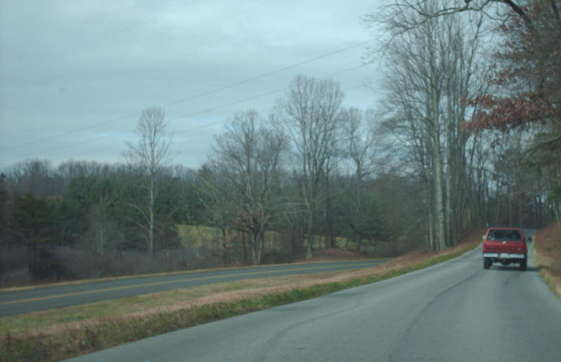
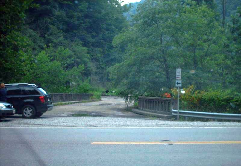
Photo: old VA 109 westbound along the Blue Ridge Pkwy (photo by Mapmikey 12/8/07)
| VA 101
to 120 < VA 81 to 100 | Home | VA 121 to 140 > |
Photo: old VA 109 westbound along the Blue Ridge Pkwy (photo by Mapmikey 12/8/07) |
| ||||||||
| ROUTE LOG VA 117: 0 - 0 VA 116: 1.34 - 1.34 I-581 (exit 3), US 220: 0.58 - 1.92 US 11: 1.25 - 3.17 |
|
|||||||
| Previous VA 101's:
1928 ROUTE LOG VA 10: 0 - 0 END VA 101: 13.5 - 13.5 1932 ROUTE LOG US 411, VA 10: 0 - 0 TN STATE LINE: 3.7 - 3.7 1960 ROUTE LOG US 11: 0 - 0 VA 100Y NB: 0.60 - 0.60 VA 100Y SB: 0.19 - 0.79 VA 100: 0.05 - 0.84 |
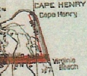
VA 101 #1: Appeared in June 1923 (CTB) as new primary routing,
running from VA 10 (either 24th St or 17th St) Virginia Beach north 3.5
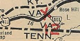
miles to Fort Story. In June 1926 (CTB), VA 101 was extended west 7.3 miles towards Lynnhaven Inlet as an upgrade to CR 1. In March 1927 (CTB), VA 101 was extended west 2.41 miles. In Aug 1928, VA 101 was renumbered as VA 500. Today it is US 60 except it used the old VA 305 around Cape Henry and along the oceanfront VA 101 used Atlantic Ave. 1927 and 1928 Officials erroneously show VA 101 curling southwest back to Norfolk. However, the current US 13 corridor was not put into the system until Aug 1928. VA 101's furthest reach was just to the west of the Lynnhaven Inlet. VA 101 #2: Appeared Aug 1928 as an upgrade to CR 4, running from US 411/VA 10 (now US 58 Bus) Ewing south to the Tennessee Line. The 1928-29 Officials erroneously show the road going to Rose Hill. In July 1933, VA 101 was renumbered as VA 62. Today it is SR 744.
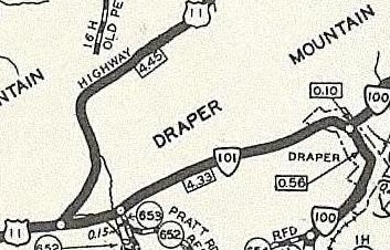
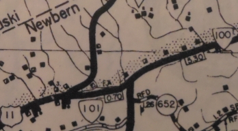
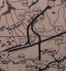
VA 101 #3: Appeared July 1933 as a renumbering of part of VA 10 from US 11 (now F-047 on southside of I-81) west of Draper mtn to VA 100 (now SR 658) Draper.
|
|||||||
| ||||||||
| ROUTE LOG SR 644: 0 - 0 WV STATE LINE: 0.85 - 0.85 WV STATE LINE: 0 - 0.85 WV STATE LINE: 0.20 - 1.05 WV STATE LINE: 0 - 1.05 US 19: 4.71 - 5.76 WV STATE LINE: 2.44 - 8.20 |
Creation: Appeared in March 1958 (CTB) as a renumbering of VA 85. Had the same endpoints as it does now. This is the 4th VA 102.
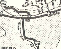
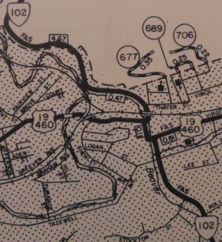
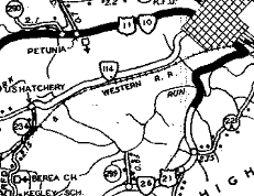
Adjustments: Between 1962-75, VA 102 was rerouted in Bluefield to a more direct route across the railroad. It left College Av and went west a block (with a rerouted US 19-460) on Virginia Ave then north on Walnut, then east on Graham back to College Av north under the railroad. Originally it had used Graham St east to Depot St to Thayer St. Sometime after 1975, VA 102 was removed from its US 19-460 duplex by remaining on College Av straight through. In March 2000 (CTB), VA 102 was put on newly constructed alignment north of Bluefield, leaving behind SRs 842 and 843. Improvements: Paved upon designation; no multilane segments Posted: Fully posted except the turn from College Dr onto Stadium Dr is not marked. Stadium Dr onto College Ave is marked with a cutout, however. Two other cutouts were still up as of 2009 Triangle shaped cutouts exist at US 19 Interstate-shaped cutouts are sprinkled througout Bluefield and go back to the early-2000s at least. The very brief Virginia dip between the Pocahontas segment and the Bluefield segment is not posted; the Pocahontas segment is poorly posted. Multiplexes: None Legislative names: Clyde Bowling Bridge at Falls Mill, since 3-22-99. Other names: College Ave/Stadium Dr (Bluefield) Scenic Byway: None Comment: VA 102 crosses the WV/VA state line 4 times between Bluefield and Pocahontas.
| |||||||
| Previous VA 102's:
1928 ROUTE LOG US 411, VA 10: 0 - 0 TN STATE LINE: 3 - 3 1932 ROUTE LOG US 411, VA 10: 0 - 0 TN STATE LINE: 7.36 - 7.36 1953 ROUTE LOG US 221: 0 - 0 VA 355: 28.5 - 28.5 US 11: 0.5 - 29 |
VA 102 #1: Appeared in June 1923 (CTB) as new primary routing from VA 10 (now US 58-421) near Weber City southeast to Tennessee at Wadlow Gap.
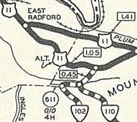
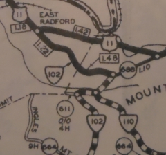
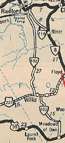
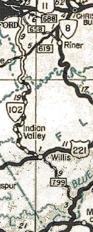
In March 1924, the General Assembly moved the route to run from VA 10 (now the VDOT Maint yard at SR 613) Weber City south to the Tennessee State Line. The old route is today's VA 224 corridor (e.g. several SR 95x loops in addition to some of VA 224). In Aug 1928, VA 102 was renumbered as VA 108. Today it is US 23 except it used the SR 727 loop near the state line. VA 102 #2: Appeared in Aug 1928 as an upgrade to CR 9, running from US 411/VA 10 (now US 58) Cony Hollow south 6.16 miles. In Dec 1930 (CTB), VA 102 south was extended to the Tennessee Line. In July 1933, VA 102 was renumbered as VA 63. Today it is SR 758. VA 102 #3: Appeared in July 1933 as a renumbering of VA 210, running from US 11 (now SR 688 Auburn Ave) Radford south to US 221 Willis, then after a duplex with US 221 to Shelors Mill, VA 102 continued south to end at US 58 Meadows of Dan. There was a break in routing around the Floyd-Patrick Line. In Aug 1933 (CTB), the 4.4 mile gap was closed in VA 102. In March 1934 (CTB), VA 102 was officially moved from SR 726 Shelors Mill to today's SR 799 Willis. The decision to do this occurred in 1932 while the route was still VA 210 TEMP (the '33 Official showed the move, too), but the official mileage transfer didn't occur until now. In Jan 1937 (CTB), VA 102 was extended north along Auburn Ave and Tyler Ave to end at US 11. This was a replacement for what had become US 11 ALT.
In May 1943 (CTB), VA 102 from Willis to Meadows of Dan was downgraded to SR 799. In Apr 1951 (CTB), the rest of VA 102 was designated to revert to secondary status when primary funds allocated were depleted. In Oct 1954 (CTB), VA 102 was downgraded to SR 787. In Radford, VA 102 used Rock Rd east to Auburn then northwest into Radford. The Tyler Ave portion of VA 102 is now part of VA 177. SR 787 is seriously twisty in its Willis to Radford portion. Near Meadows of Dan there is now a brief duplex with the Blue Ridge Pkwy.
|
|||||||
| |||||||
| ROUTE LOG VA 8: 0 - 0 NC STATE LINE: 13.43 - 13.43 |
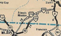
Multiplexes: None Legislative names: Dolley Madison Boulevard, from I-495 and VA 193 (since 6-21-62) Other names: Claudeville Hwy (e of SR 773); Dry Pond Hwy (w of SR 773) Scenic Byway: No segments Comment: VA 103 is an efficient route today compared to its winding eastern third of yesteryear. It provides good access to Mt Airy, NC from US 58 via VA 8. |
||||||
| Previous VA 103's:
1928 ROUTE LOG US 117, VA 10, VA 12: 0 - 0 NC STATE LINE: 14 - 14 1932 ROUTE LOG TN STATE LINE: 0 - 0 VA 103Y: 13.8 - 13.8 GAP IN ROUTE: 0 - 13.8 BEGIN VA 103: 0 - 13.8 US 411 EB, VA 10 EB: 8.1 - 21.9 VA 11: 2.5 - 24.4 US 411 WB, VA 10 WB: 2.5 - 26.9 END VA 103: 6.1 - 36.0 |
VA 103 #1: Appeared 1923 as a renumbering of VA 12W, running from VA 10 (curr VA 337) Suffolk south to the NC Line. VA 103 used White Marsh Rd down to VA 32 originally.
|
||||||
| VA 104 not currently assigned | ||||||||
| Previous VA 104's: 1928 ROUTE LOG END VA 104: 0 - 0 VA 20: 4 - 4 GAP IN ROUTE BEGIN VA 104: 0 - 4 US 60, VA 10: 4 - 8 VA 13 WB: 19 - 27 VA 13 EB: 4 - 31 1932 ROUTE LOG US 411, VA 10: 0 - 0 KY STATE LINE: 7.11 - 7.11 1948 ROUTE LOG VA 103: 0 - 0 NC STATE LINE: 8.9 - 8.9 2001 ROUTE LOG US 17: 0 - 0 VA 165: 3.86 - 3.86 VA 166: 0.94 - 4.80 BEGIN I-464, VA 190: 1.60 - 6.40 I-64: 0.74 - 7.14 I-464 NB, US 13: 0.64 - 7.78 |
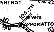
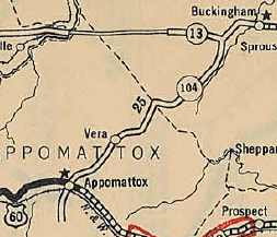
VA 104 #1: Appeared in 1923 as new primary routing, running from VA 10 (now US 460 Bus) Appomattox northeast to Vera.
In March 1924 (CTB), VA 104 was extended northeast 5 miles. In June 1926 (CTB), VA 104 was extended northeast 9.2 miles to VA 13 (now US 60) Mt Rush, then duplexed with VA 13 to Buckingham C.H. In March 1927 (CTB), VA 104 was extended south 4 miles from Appomattox. There is evidence in the Aug 1928 CTB that VA 104 replaced VA 202 from Charlotte C.H. to Drakes Branch in 1928. In Aug 1928, VA 104 was renumbered as part of VA 304 from Darkes Branch to Charlotte C.H. (now VA 47); VA 306 from south of Appomattox to Mt. Rush (now SR 604, SR 727, VA 131, VA 24); VA 13 from Mt. Rush to Buckingham (now US 60). The 1926 Official erroneously shows VA 104 running directly to Buckingham C.H. without passing through Mt Rush.
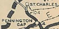
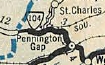
VA 104 #2: Appeared in Aug 1928 as new primary routing running from US 411/VA 10 (now US 58 ALT) Pennington Gap northwest 3 miles. In Dec 1930 (CTB), VA 104 was extended west 2.25 miles. In July 1932 (CTB), VA 104 was extended west 2.25 more miles to the Kentucky State line. In July 1933, VA 104 was renumbered as VA 65. Today it is part of US 421.
VA 104 #3: Appeared in July 1933 as a renumbering of VA 200, running from VA 103 near Claudeville to Ararat. See scan under current VA 103 entry. In Sept 1934 (CTB), VA 104 was extended west to the North Carolina line near Mt. Airy, NC. In June 1941 (CTB), VA 104's east end was moved to Claudeville. The old route to VA 103 became SR 738. In Apr 1949, the CTB designated VA 104 to be downgraded to secondary status. Patrick County objected and was given an audience with the CTB, which in Oct 1949 reaffirmed their decision and VA 104 became SR 773. VA 104 #4: Designated in Nov 1962 (CTB) to cover the construction of a road from I-64/464 southwest to US 17 south of Deep Creek. This included a duplex with existing VA 166. In Dec 1962, the CTB deferred action on renumbering VA 104 as VA 464. In Aug 1965 (CTB), VA 104 was put into the primary system from US 17 to VA 190. The 1968 Official shows VA 104 completed from VA 190 to US 13 Military Hwy. In Dec 2001 (CTB), VA 104 was dropped from I-464 between US 13 and I-64 and was renumbered as US 17 south of there. VA 104 was also signed on its northern beginning from US 17 NB as "Ocean Hiway" in a US route shield in the 1980s. VA 104 was one of the earliest non-interstate routes to have mile markers on it.
|
|||||||
| |||||
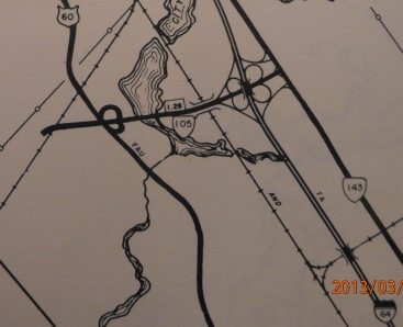
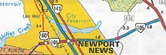
| ROUTE LOG BEGIN VA 105: 0 - 0 US 60: 0.04 - 0.04 I-64 (exit 250): 1.01 - 1.05 VA 143: 0.23 - 1.28 York-Newport News Line: 1.26 - 2.54 US 17: 2.36 - 4.90 |
Creation: Designated by Aug 1958 (CTB) and actually put
into the primary system Aug 1960 (CTB) as new construction from VA 168
(now VA 143) west to Fort Eustis. This is the 4th VA 105.
Adjustments: In Aug 1975 (CTB), VA 105 was extended east to US 17 as new construction. Improvements: Fully paved and multilaned upon inception. The 1975 extension to US 17 was initally 2 lanes, but recently widened to 4 lanes. Posted: Fully posted; Multiplexes: None Legislative names: None Other names: Fort Eustis Blvd Scenic Byway: None Comment: VA 105 provides direct access to Fort Eustis from I-64 and US 17 Yorktown area. VA 105 is considered a "limited access route". Some of the early '80s Hampton Roads insets on the VDOT map showed it as a blue line (limited access), though recent map insets don't. An extension east to VA 173/Goodwin Neck Rd is proposed as SR 1050, which has been built over to SR 634. VA 105 didn't appear on officials until 1975.
| ||||
| Previous VA 105's:
1928 ROUTE LOG US 11, VA 10: 0 - 0 END VA 105: 14.1 - 14.1 GAP IN ROUTE BEGIN VA 105: 0 - 14.1 US 19 SB, VA 11 WB: 17.5 - 31.6 US 19 NB, VA 11 EB: 2 - 33.6 WV STATE LINE: 10 - 43.6 1931 ROUTE LOG US 411, VA 10: 0 - 0 END VA 105: 8.85 - 8.85 1941 ROUTE LOG US 58: 0 - 0 SR 626: 5.66 - 5.66 |
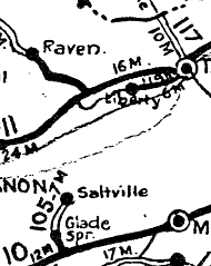
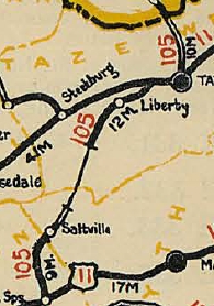
VA 105 #1: Appeared in May 1923 (CTB), running from VA 10 (now US 11) Old Glade Spring north to Saltville.
In 1926, VA 105 replaced VA 119 from VA 11 (now US 19-460 Bus) Frog Level to Liberty, then duplexed with VA 11 to Tazewell, then replaced VA 117 north to the West Virginia line at Bishop. In June 1926 (CTB), VA 105 was extended northeast 6.6 miles. Also, the Tazewell County piece was extended south 5.5 miles. In March 1927 (CTB), the original VA 105 segment was extended north 0.5 miles and the northern piece was extended south 6 miles. In Aug 1928, both pieces of VA 105 were renumbered as VA 112. Today it is VA 91 below Tazewell except it used VA 91 Bus and SR 1309 through Glade Spring. ABove Tazewell it is part of VA 16. VA 105 #2: Appeared Aug 1928 as new primary routing, running from US 411/VA 10 (now US 421) Dot southwest 3.25 miles. See scan under VA 103 #2 entry. In June 1930 (CTB), VA 105 was extended west 0.75 miles. In Dec 1930 (CTB), VA 105 was extended west 4.85 miles to near Jonesville. In 1932, VA 105 was renumbered as an extended VA 103. Today, it is part of US 58. VA 105 #3: Appeared in July 1933 as a renumbering of a VA 2xx route created in 1932 whose number I haven't been able to ascertain. It ran from US 58 northeast 5.66 miles through Critz ending in the vicinity of the Grays Creek Bridge. In Sep 1942 (CTB), VA 105 was downgraded to SR 626. For some reason the 1933 official shows VA 105 ending in Critz but that was definitely never true.
|
||||
| |||||
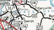
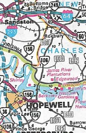
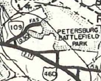
| ROUTE LOG US 460, US 460 Bus: 0 - 0 Prince George-Petersburg Line: 0.10 - 0.10 VA 156 SB, VA 156 Bus: 4.75 - 4.85 VA 10 WB, VA 156 Bus: 4.56 - 9.41 VA 10 EB: 0.73 - 10.14 Charles City-Prince George Line: 2.69 - 12.83 VA 5, VA 156 NB: 1.31 - 14.14 New Kent-Charles City Line: 9.80 - 23.94 US 60: 0.91 - 24.85 I-64 (exit 211), VA 33: 3.04 - 27.89 VA 249: 1.68 - 29.57 |
Creation: VA 106 was created Oct 1940 (CTB) as a renumbering of VA 37 #3, running from US 460 to VA 10 Garysburg. This is the 4th VA 106.
Adjustments: In May 1953 (CTB), VA 106 east was truncated to VA 154 (now VA 156) south of Hopewell, leaving behind SR 609. In Jan 1987 (CTB), VA 106 was extended with VA 156 into Charles City COunty, then replaced SRs 609 and SR 605 to end at VA 249. Around the Roxbury area this had once been part of VA 163. Improvements: paved upon inception; multilane on its VA 10 duplex when assigned there in 1987. In the early 2010s, VA 106 was widened to 4 lanes from just north of I-64 to VA 249 as part of a real estate development. Posted: Fully posted; In the 90s there was a circle 106 shield north of VA 5. Multiplexes: VA 156 (8.56 mi) VA 10, VA 156 (0.73 mi) Legislative names: Colonial Trail, US 460 to SR 609 (3/24/30 designation predates VA 106); Benjamin Harrison Memorial Bridge over James River (10-13-66 designation predates VA 106); Other names: Courthouse Rd (w of VA 156); James River Dr (Va 10 duplex); Roxbury Rd (Charles City Co) Scenic Byway: No segments Comment: The above-mentioned real estate development included three roundabouts along VA 106, including one at the VA 106/VA 249/SR 609 junction. The CTB extended VA 106 to provide a continuous number to connect New Kent/Charles City to Prince George/Petersburg. How many people make this movement anyway...?
| ||||
| Previous VA 106's:
1928 ROUTE LOG END VA 106: 0 - 0 US 11 NB, VA 10 EB: 5 - 5 US 11 NB, US 19 SB, VA 10 EB: 1 - 6 US 19 NB, VA 112: 14 - 20 VA 11: 7 - 27 1932 ROUTE LOG US 23 SB, US 411, VA 10: 0 - 0 VA 142: 5 - 5 VA 11 WB: 17 - 22 VA 119: 2 - 24 US 23 NB, VA 11 EB: 1 - 25 KY STATE LINE: 8 - 33 1940 ROUTE LOG US 220: 0 - 0 NC STATE LINE: 6 - 6 |
VA 106 #1: Appeared in 1923 as a renumbering of VA 10Y, running from VA 10 (now US 11) Abingdon to VA 11 (now VA 71) Dickensonville.
|
||||
| ||||||||
| ROUTE LOG I-81 (exit 35): 0 - 0 US 11: 0.32 - 0.32 VA 91: 8.07 - 8.39 |
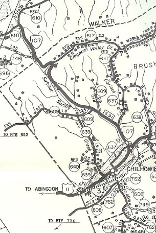
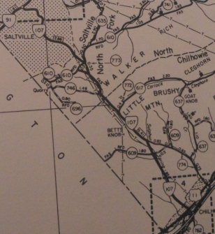
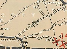
Creation: Appeared in Jan 1961 (CTB) as an upgrade to SR 636, running from US 11 Chilhowie to SR 610 near Quarry. This is the 4th VA 107.
Adjustments: In Jan 1966 (CTB), VA 107 was extended to VA 91 Saltville as new construction. In Oct 1966 (CTB), VA 107 was straightened out in the Quarry area, leaving behind SR 773 and also SR 617 Horseshoe Bend Dr/Sparks Ln. In Aug 1968 (CTB), the south end of VA 107 was moved from the east edge of Chilhowie (leaving behind SR 774 Lyons Gap Rd) to its current route opposite SR 762. This was partially new construction and partially an upgrade to SR 639. In Nov 1968 (CTB), VA 107 was extended south to I-81 replacing SR 762 (was once VA 79). In June 1970 (CTB), the Cumberland Plateau Planning District requested VA 107 be expanded to "tie together the reecreation areas of Mt. Rogers, Clinch Mtn Wildlife Management Area and Breaks Interstate Park." My speculation is that it would've used some of SR 613 through Allison Gap plus new construction to tie into US 19 near VA 80 Rosedale. Southward, it would've used SR 762 and SR 600 down to US 58. The June 1972 CTB mentions Smyth County Board of Supervisors passing a resolution to extend VA 107 over SR 762 to SR 600. Improvements: Fully paved upon inception; no multilane segments Posted: Fully posted; cutouts in each direction on SR 610; EB set was gone in 2009. Multiplexes: None Legislative names: None Other names: White Top Ave (Chilhowie); Worthy Blvd (Saltville) Scenic Byway: None Comment: VA 107 provides direct access to Saltville from I-81. Not that VA 91 is a bad route in this area. Official maps suggest all the extensions, etc all took place by 1962.
| |||||||
| Previous VA 107's:
1928 ROUTE LOG US 25E NB, US 411, VA 10: 0 - 0 TN STATE LINE: 0.15 - 0.15 1932 ROUTE LOG TN STATE LINE: 0 - 0 US 411 EB, VA 10 EB: 3 - 3 US 23 NB, US 411 WB, VA 10 WB: 2 - 5 VA 122: 19 - 24 VA 11: 11 - 35 1952 ROUTE LOG US 58: 0 - 0 NC STATE LINE: 9.90 - 9.90 |
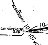
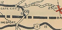
VA 107 #2: Appeared in Aug 1928 as new primary routing, running from VA 11 (now US 58 ALT) Parsonage southwest into Scott County, then replaced what had just been assigned as VA 122 to the Snowflake area, then extended 4.8 more miles as new routing. In Aug 1929 (CTB), VA 107 was extended west as new routing to US 23-411/VA 10 Gate City. In 1932, VA 107 was extended south with US 23 to the Tennessee Line. South of Weber City was a replacement for VA 108. In 1932, US 23/VA 107 was removed from SR 727 near the TN line. In July 1933, VA 107 was renumbered as VA 71 from Gate City to Parsonage and remained US 23 from Gate City to Tennessee (now US 23 BUs; SR 613; VDOT Maint yard; US 23 to TN)
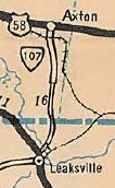
VA 107 #3: Appeared in July 1933 as a renumbering of a VA 2xx route created in 1932 whose number I haven't been able to ascertain. It ran from US 58 Axton south towards the Aiken Summit area. In Sept 1934 (CTB), VA 107 was extended south 4.77 miles. In Oct 1935 (CTB), VA 107 was extended south to the North Carolina line near Eden, NC. In May 1953 (CTB), VA 107 was downgraded to SR 610.
|
|||||||
| |||||||
| ROUTE LOG VA 174: 0 - 0 SR 657, SR 890: 4.24 - 4.24 |
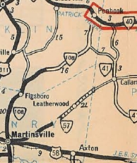
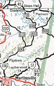
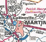
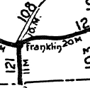
Creation: Appeared July 1933 as a renumbering of VA 202, running from US 311/VA 57 (now Church St) Martinsville northeast via Walnut St and Franklin St to VA 40 Penhook. This is the 3rd VA 108.
Adjustments: In Dec 1938 (CTB), VA 108 was removed from SR 714 College Dr. In Nov 1940 (CTB), VA 108 was rebuilt in Franklin County in several places leaving a bunch of aandoned alignments plus an extended SR 630. In Aug 1949 (CTB), VA 108 was rerouted in Martinsville to begin at Church St, using Moss Street from Church Street to Fayette Street; thence along Fayette, Jones and Liberty Streets to Franklin Street. In May 1952 (CTB), VA 108 north was truncated to its current end in Figgsboro, replaced by SR 890. In Sept 1972, Henry County unsuccessfully lobbied the CTB to re-extend VA 108 back to VA 40. In Feb 1974 (CTB), VA 108 was removed from SR 988 Appletree Cir. In July 1974, Franklin County also unsuccessfully lobbied the CTB to re-extend VA 108 back to VA 40. In Nov 1990 (CTB), VA 108 south was truncated to and replaced by VA 174. Improvements: Paved upon inception out to Snow Creek In 1940, VA 108 was paved out to VA 41 (now SR 969). In 1948, VA 108 was paved from VA 41 to VA 40. No multilane segments Posted: Fully posted Multiplexes: None Legislative names: None Other names: Figsboro Rd Scenic Byway: No segments Comment: Figsboro is not exactly a huge place so I don't know why VA 108 was retained all these years. The SR 890 continuation to VA 40 is a pretty good road and wouldn't need any work to put back in the system if traffic ever warranted it.
| ||||||
| Previous VA 108's:
1928 ROUTE LOG NC LINE: 0 - 0 VA 12 WB: 11 - 11 US 117 EB, VA 12 EB: 2 - 13 VA 10: 19 - 32 1931 ROUTE LOG TN LINE: 0 - 0 US 23 NB, US 411, VA 10: 3 - 3 |
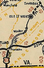
VA 108 #1: Appeared in May 1923 (CTB) as an upgrade to CR 1. It ran from VA 10 Smithfield to Isle of Wight C.H.
In March 1924 (CTB), a separate piece of VA 108 was created from VA 12 (now US 58-258 Bus) near Franklin northeast 4 miles. In Jan 1925 (CTB), the southern piece of VA 108 was extended north 5 miles. In Jun 1926 (CTB), the southern piece was extended north 4.6 miles. In Oct 1926, VA 108 replaced VA 121 from Franklin south to the NC Line. This In late 1926, US 117 was added from Franklin to North Carolina. In March 1927 (CTB), the southern piece was extended north 3.1 miles. In Aug 1928, Both piece of VA 108 (the gap was 4 miles) was renumbered as VA 507. Today it is US 258 and US 258 Business, except in Franklin it used High St to 4th St.
|
||||||
| ||||||||
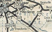
| ROUTE LOG US 460 Bus: 0 - 0 Prince George-Petersburg Line: 0.88 - 0.88 END VA 109: 0.03 - 0.91 |
| |||||||
| Previous VA 109's:
1928 ROUTE LOG US 11, VA 10: 0 - 0 VA 23: 22 - 22 1932 ROUTE LOG US 11, US 19, VA 10: 0 - 0 US 11, US 19, VA 10: 5 - 5 1945 ROUTE LOG US 221: 0 - 0 Blue Ridge Pkwy: 7 - 7 VA 40: 2.8 - 9.8 |
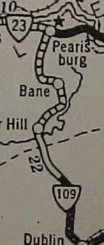
VA 109 #1: Appeared in June 1923 as new primary routing. It ran from VA 10 (now SR 767) Dublin north to Poplar Hill.
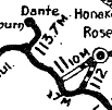
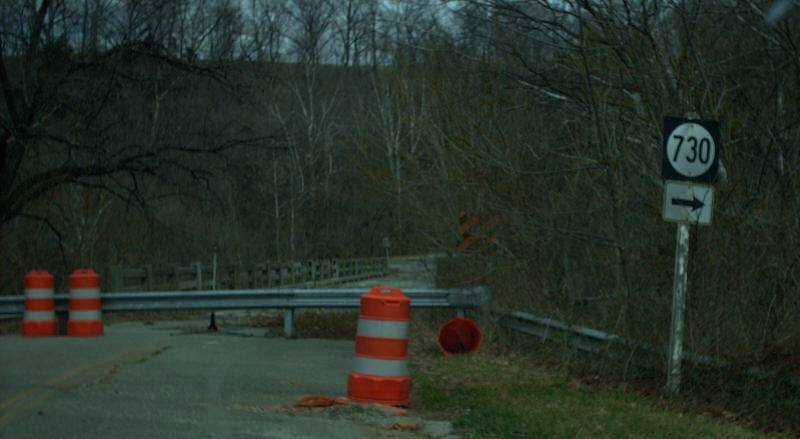
In Jan 1925 (CTB), VA 109 was extended north 5 miles. In June 1926 (CTB), VA 109 was extended to VA 23 (now US 460 Bus) Pearisburg. In Aug 1928, VA 109 was renumbered as VA 213. Today it is SR 746 Giles Ave in Dublin; VA 100 to poplar Hill except VA 109 used the twisty alignment west of VA 100 up the mountain; SR 660 Cedar Crest Loop; abandoned bridge over Walkers Creek; SR 730; VA 100 to Pearisburg except SR 811 Bane Rd
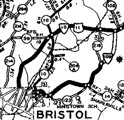
VA 109 #2: Appeared in Aug 1928 as new primary routing, running from US 11-19/VA 10 (now just Texas St) Bristol east via Massachusetts Ave and King Mill Pike 3.24 miles. In Feb 1930 (CTB), VA 109 was extended west using Fairview St, Danville Ave, Goodson St and Mary St to end at the rerouted US 11-19/VA 10 on Piedmont Ave In Dec 1930 (CTB), VA 109 was extended east back to US 11-19/VA 10. In July 1932 (CTB), VA 109 was rerouted in Bristol to follow Goodson south to State St then west to end at Piedmont. This placed EB VA 109 in Tennessee. Mary St west to Front St became VA 109Y while the rest became unnumbered. In July 1933, VA 109 was renumbered as VA 76. Today east of Bristol VA 109 used Old Airport Rd to reach US 11-19. VA 109 #3: Appeared on the 1933 draft route list running from Woolwine to near Endicott. This would've been a renumbering of a piece of VA 20. When the 1933 map came out, this was part of VA 40 instead.

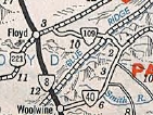
VA 109 proposed to run out of Woolwine 1933 draft route list VA 109 #4: Appeared July 1933 as a renumbering of VA 222, running from US 221 east of Floyd over the mountain to end at VA 40. On the 1933 draft route list this had been slated to be the last part of VA 10. Endicott. There was a gap on the Floyd County side of the mountain. In Aug 1933 (CTB), the gap was closed in VA 109. In May 1946 (CTB), VA 109 was downgraded to SR 860. The Franklin County side of old VA 109 is narrow and winding, with absolutely nothing there. The Floyd County side is a pretty decent road. The 1933 Official erroneously shows VA 109 running directly to Floyd along today's SR 615 but that has never been the case.
VA 109Y: Looks to have been created in July 1932 running from State St north on Front St to Mary St then east to Goodson. This was new routing except the Mary St portion was a renumbering of VA 109. In July 1933, VA 109Y became VA 76Y. Today these are all unnumbered streets. |
|||||||
| |||||
| ROUTE LOG I-395 (exit 8), US 1: 0 - 0 VA 27: 1.00 - 1.00 I-66 (exit 75): 1.27 - 2.27 |
| ||||
| Previous VA 110's:
1932 ROUTE LOG END VA 106: 0 - 0 US 11 NB, VA 10 EB: 14 - 14 US 11 NB, US 19 SB, VA 10 EB: 1 - 15 US 19 NB, VA 131: 14 - 29 VA 134: 3 - 32 VA 11: 4 - 36 1945 ROUTE LOG VA 8: 0 - 0 VA 102: 6.20 - 6.20 |
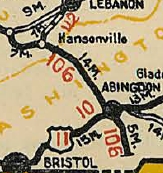
VA 110 #1: Appeared Aug 1928 as a renumbering of VA 106, running
from VA 11 (now VA 71) Dickensonville through Hansonville and Abingdon
before ending 5 miles south. Hansonville to Abingdon was also US 19.
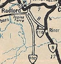
In Aug 1929 (CTB), VA 110 was extended south 3.12 miles. In Dec 1930 (CTB), VA 110 was extended south 3.24 more miles, to be 0.14 miles short of the Tennessee State lIne. In July 1933, VA 110 was renumbered as VA 71 from Dickensonville to Hansonville (now US 58 ALT); US 19 remained from Hansonville to Abingdon (except SR 766 near Abingdon; SR 633 loop at Butts; SR 775 at Greendale; SR 876/802 at Holton.) ; Main St in Abingdon remained US 11; south to nearly Tennessee became VA 77 (now VA 75 except used Green Spring Rd in Abingdon and the SR 902/677 loop). VA 110 was not labeled on official maps north of Abingdon but is shown on the 1932 Russell County Map. VA 110 #2: Created July 1933 as a renumbering of VA 211, running from VA 102 (now an old alignment of Rock Rd) Radford to VA 8 Riner. In May 1946 (CTB), VA 110 was downgraded to SR 658. Today, I-81 cuts off old VA 110. North of I-81 the road is now a piece of 7 Mile Tree Rd; SR 666; SR 600; VA 177; abandoned routing near Rock Rd (off the SW corner of VA 177-Rock Rd jct). VA 110 #3: Created June 1947 (CTB) - "Beginning at a point on Henry Street just south of the intersection of First Street, thence over a proposed new location and new route to the intersection of Washington and Second Streets; thence over Second Street to the dead end at the Potomac River" (0.29 miles total) Thus, VA 110 was unbuilt from US 1 to the George Washington Memorial Parkway, and existed on 2nd St from GW Pkwy east to the Potomac River. VA 110 was cancelled in March 1956 (CTB). The CTB indicates 0.16 miles (presumably 2nd St) was to stop receiving primary mileage payments. The March 1956 CTB also indicated the cancellation was because a proposed Potomac River Bridge would be built elsewhere. VA 110 appeared on 1950-53 Officials.
|
||||
| |||||
| ROUTE LOG US 460 Bus: 0 - 0 US 11, US 460 Bus: 2.26 - 2.26 |
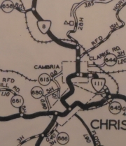
Creation: Appeared in July 1933 as a renumbering of VA 218, running from VA 8 (now just Depot St) Cambria east to US 11 Christiansburg. This is the 3rd VA 111.
Adjustments: About 1936, VA 111 was extended west replacing VA 8 out to the new routing of VA 8 (curr US 460 Bus). In 1936, VA 111 was placed on new alignment east of Depot St, leaving behind a wavy routing very close to the railroad tracks. At some point (my guess is when US 460 Bypass of christiansburg was built in late 1960s) after 1958, VA 111's west end was reconfigured to today's endpoint, leaving behind Palmer St. Improvements: Paved in 1936; no multilane segments Posted: Fully posted; One cutout EB leaving Depot St in Cambria was still there as of late 2009. Multiplexes: None Legislative names: None Other names: Cambria Rd, Depot St Scenic Byway: No segments Comment: VA 111 can be used as a bypass of downtown Christiansburg, but the speed limits are 25-35 mph on most of it. I'm a little surprised US 460 wasn't put on this route in some manner decades ago.
| ||||
| Previous VA 111's:
1928 ROUTE LOG US 19, VA 11: 0 - 0 END VA 111: 39 - 39 1932 ROUTE LOG VA 112: 0 - 0 US 11, VA 10: 6 - 6 END VA 111: 5 - 11 GAP IN ROUTE BEGIN VA 111: 0 - 11 US 19 SB, VA 11 WB: 14 - 25 US 19 NB, VA 11 EB: 3 - 28 VA 138: 6 - 34 CR 7: 14 - 48 GAP IN ROUTE BEGIN VA 111: 0 - 48 VA 121 WB: 7 - 55 VA 121 EB: 1 - 56 CR 6: 8 - 64 |
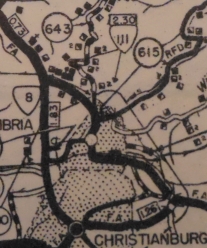
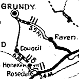
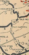
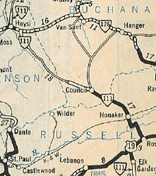
VA 111 #1: Appeared in 1923 as a renumbering of VA 11X, running from VA 11 (now US 19) Claypool Hill to Grundy. In August 1928, VA 111 was renumbered as VA 126. Today it is US 460 and US 460 Bus through Cedar Bluff; Edgewater Dr; US 460 Bus through Richlands; VA 67/SR 751/SR 806 through Raven; SRs 804/805 Red Ash; SR 727 Grimleysville; SR 721 in Keen Mountain/Marvin; SRs 759 and 1013 in Janney; SR 725 in Tookland. There are innumerable abandoned alignments of US 460 on the big curves following various mountain streams. VA 111 #2: Appeared Aug 1928 as a two piece route: US 11/VA 10 Cedarville to Meadowview (renumbering of VA 125), then continued replacing CR 2 for a total of 5 miles; new primary routing from US 19/VA 11 Elk Garden south 3 miles. In Dec 1930 (CTB), the northern piece was extended south 2.61 miles to the Washington County line, then south 7 more miles. In 1932, VA 111 north was extended east with US 19 to Rosedale, then replaced VA 125 northwest through Honaker and after a gap through Haysi. In July 1932, VA 111 was extended south from US 11 to VA 112 (now old VA 91 loop) Rock Spring Church. This had been VA 125 until 1928. Also in July 1932, VA 111 was extended north 6.06 miles from its Haysi north end towards Kentucky and the south end of the Haysi piece was extended southeast to the Dickenson County line. In July 1933, all parts of VA 111 were renumbered as VA 80. Today it is SR 803 southeast of US 11; VA 80 over to US 19; abandoned alignment to the north of 19 to Rosedale; the route from Honaker south to the Holston River ran to the west of today's VA 80 using a bit of SR 672 and Clover Rd but is mostly not a road today; VA 80 to near Breaks; SR 609/768 loop at Breaks.
|
||||
| |||||
| ROUTE LOG US 11, US 460: 0 - 0 Roanoke County-Salem Line: 0.44 - 0.44 I-81 (exit 137): 0.17 - 0.61 F-070: 0.04 - 0.65 |
| ||||
| Previous VA 112's:
1928 ROUTE LOG US 19 SB, VA 106: 0 - 0 US 19 NB, VA 11: 7 - 7 1932 ROUTE LOG VA 12: 0 - 0 US 11, VA 10: 6 - 6 US 19 SB, VA 11 WB: 39 - 45 VA 113: 1 - 46 US 19 NB, VA 11 EB: 2 - 48 VA 127: 2 - 50 WV STATE LINE: 8 - 58 1942 ROUTE LOG VA 8: 0 - 0 SR 613: 7 - 7 |
VA 112 #1: Appeared in 1923 as new routing running from VA 106
(now old US 58 ALT, slightly SE of modern US 58 ALT) Hansonville to VA
11 (now SR 1030 which is Old VA 71) Lebanon. About 1927, US 19 was added to the entirety of VA 112. In Aug 1928, VA 112 was renumbered as VA 131. Today it is US 19 up to SR 674, then abandoned alignment on the north side to Sunset Dr; US 19; SR 841 (except used SR 758 loop) to US 19 Bus; tiny bit of 19 Bus; Gilbert St VA 112 #2: Appeared Aug 1928 as a renumbering of VA 105 running from US 11/VA 10 Old Glade Spring north through Saltville and Tazewell to West Virginia at Bishop, with a gap above the Tazewell-Smyth County line being added as new primary routing. Also in Aug 1928 (per Feb 1930 CTB), VA 125 from Cedarville southeast to Rock Spring Church was removed from the state highway system by act of legislature, in exchange for VA 112 being established from Old Glade Spring to VA 12 (now SR 762) Lodi. In July 1933, VA 112 was renumbered as VA 81. Today it is VA 91 below Tazewell except it used VA 91 Bus and SR 1309 through Glade Spring. Through and above Tazewell it is VA 16. VA 112 #3: Appeared in July 1933 as a renumbering of VA 224, running from VA 8 (now SR 783) Maybrook north to Mountain Lake. In May 1943 (CTB), VA 112 was downgraded to SR 700.
|
||||
| |||||
| ROUTE LOG US 11E, US 19, US 421, VA 381: 0 - 0 US 421: 0.28 - 0.28 US 11, US 19: 1.05 - 1.33 |
| ||||
| Previous VA 113's:
1928 ROUTE LOG VA 11: 0 - 0 END VA 113: 7 - 7 1932 ROUTE LOG VA 12: 0 - 0 US 11 SB, VA 10 WB: 17 - 17 US 11 NB, VA 10 EB: 0.5 - 17.5 CR 1: 12.5 - 30 GAP IN ROUTE CR 4-101: 0 - 30 US 19, VA 11, VA 112: 4.7 - 34.7 1941 ROUTE LOG VA 311: 0 - 0 SR 658: 6.90 - 6.90 |
VA 113 #1: Appeared March 1923 (CTB) as new primary routing, running from VA 11 (now US 58 ALT) St. Paul north to Dante
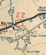
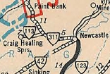
In Aug 1928, VA 113 was renumbered as VA 123. Today it is all of VA 270, then VA 63 and SR 769 to Dante. VA 113 #2: Appeared Aug 1928 as an upgrade to CR 1, running from US 11/VA 10 Marion south 6.8 miles and an upgrade to CR 17, running 6.8 miles north of US 11/VA 10 Marion. In June 1930 (CTB), VA 113 was extended south 4 miles to about Sugar Grove. In Dec 1930 (CTB), VA 113 was extended south to VA 12 (now SR 650). In June 1931 (CTB), VA 113 was extended north 1.9 miles. In July 1932 (CTB), VA 113 was extended north 3.8 miles to today's SR 610. Also, a separate piece of VA 113 was created as an upgrade to CR 4, running from US 19/VA 11-112 Frog Level south 4.7 miles to today's SR 604 east junction. In July 1933, both parts of VA 113 were renumbered as VA 88. Today it is VA 16; SR 695 through Sugar Grove area; VA 16 to Marion except SR 711, 712 and 740 loops; Prater Ln north from Marion; VA 16 to Tazewell. VA 113 #3: Appeared in July 1933 as a renumbering of VA 214, running from VA 311 west to Craig Healing Springs. In Sept 1942 (CTB), VA 113 was downgraded to SR 658.
|
||||
| |||||||
| ROUTE LOG US 11: 0 - 0 Montgomery-Pulaski Line: 2.27 - 2.27 US 460 Bus: 7.42 - 9.69 US 460: 0.63 - 10.32 |
Creation: Appeared July 1933 as a renumbering of VA 209, running in two pieces:
1. US 460 (now SR 603) Bonsack north 0.70 mile 2. US 11 near Cloverdale, north though Daleville wrapping northwest over to Catawba and Blacksburg, before ending a mile short of Prices Fork. This is the 3rd VA 114.
Improvements: Paved upon inception from Prices Fork to Blacksburg; VA 311 duplex to current VA 320; Daleville to US 11; the Bonsack piece In 1936, VA 114 was paved a few miles west of VA 311; 5 miles northwest of Daleville In 1939, VA 114 was paved from Blacksburg to Ellett; VA 320 to Botetourt Line In 1940, VA 114 was paved in Pulaski County; Catawba west to Montgomery Line Between 1942-44, VA 114 was paved from New River to Prices Fork In 1949, VA 114 was paved from Ellett to the Roanoke Line. VA 114 is first shown as multilane on the 1976 Official, from US 11 to the Army Dump entrance. VA 114 was multilaned from just west of US 460 Bus to US 460 Bypass about 2002. Posting: Fully posted; As of late 2009 there is still a VA 114 shield painted in the left lane of US 460 Bus WB Multiplexes: None Legislative names: None Other names: Peppers Ferry Blvd Scenic Byway: no segments Comment: VA 114 is technically posted east from the 460 Bypass to the unnumbered frontage road nearby. Perhaps it will be extended to I-73 someday? VA 114's WB lanes over the New River, using the original 1930s bridge, was closed to traffic in the early 2000s when a truck hit the overhead structure causing big expensive damage. This returned VA 114 to two-way traffic over the newer EB bridge. The old VA 114 alignment west of Blacksburg is mostly multilaned now. SR 785 is narrow and twisty and fun to drive; SR 779 is also narrow and twisty in Roanoke County. The Botetourt County segment is much more like a state route as a major quarry is served west of Daleville. | ||||||
| Previous VA 114's:
1928 ROUTE LOG VA 11: 0 - 0 VA 1141: 19 - 19 END VA 114: 22 - 41 1932 ROUTE LOG US 11, VA 10: 0 - 0 CR 106-254: 3.60 - 3.60 |
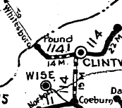
VA 114 #1: Appeared 1923 as a renumbering of VA 11Z, running from VA 11 (now va 158) Coeburn north to Georges Fork, then east through Fremont to end at Haysi. In Aug 1928, VA 114 was renumbered as VA 122 from Coeburn to Georges Fork and VA 121 from Georges Fork to Haysi. Today this is VA 72 north, SR 765 Longs Fork Rd in the Georges Fork-Clintwood area; VA 83 from Clintwood to Fremont; abandoned but standing bridge over the Clinch River in Fremont; VA 63 from Fremont to Haysi VA 114 #2: Appeared Aug 1928 as new primary routing, running from US 11/VA 10 Wytheville southwest to the Hatchery. In July 1933, VA 114 was renumbered as VA 89. Today it is US 21 Main St and SR 658 west of Wytheville.
|
||||||
| ||||||
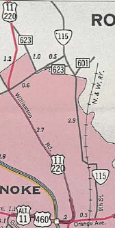
| ROUTE LOG US 221, US 460, VA 220 ALT: 0 - 0 Roanoke-Roanoke City Line: 2.86 - 2.86 US 11: 2.19 - 5.05 I-81 (exit 146), US 220: 0.95 - 6.00 |
Creation: Appeared July 1933 as a renumbering of VA 225,
running from US 460 Orange Ave to US 11 Hollins at the Botetourt County
Line. VA 115 followed Hollins Rd directly to Plantation Rd, then
northeast on SR 601 to US 11. This is the 3rd VA 115.
Adjustments: In Aug 1960 (CTB), VA 115 was rerouted to use Liberty Rd west to Plantation Rd to SR 601, etc., leaving behind a section of Hollins Rd. In Jan 1968 (CTB), VA 115 swapped routings with SR 601 to instead head northwest to I-81. In Nov 1986 (CTB), VA 115 was removed from a brief duplex it had with US 11, leaving behind McConnell Rd. Improvements: Fully paved upon designation VA 115 was multilaned from US 11 to I-81 about 1986. Posting: Fully posted; At last field visit in 2008, there was still a cutout NB near Liberty St. Multiplexes: None Legislative names: None Other names: 9th Ave, Liberty Rd, Plantation Rd. Scenic Byway: No segments Comment: VA 115 provides access to the Hollins College area (on US 11) from I-81. Otherwise it is pretty residential in Roanoke proper.
| |||||
| Previous VA 115's:
1928 ROUTE LOG VA 11: 0 - 0 KY STATE LINE: 9 - 9 1932 ROUTE LOG US 121, VA 15: 0 - 0 CR 10-112: 4 - 4 GAP IN ROUTE CR 7-261: 0 - 4 US 21 NB, VA 26 NB: 7 - 11 US 21 SB, VA 26 SB: 5 - 16 US 11, VA 10: 14 - 30 GAP IN ROUTE CR 12: 0 - 30 US 21, VA 26: 4 - 34 |
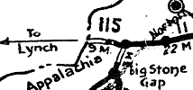
VA 115 #1: Appeared in 1923 as new primary routing, running from VA 11 (now US 23 Bus) Appalachia west to Kentucky.
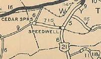
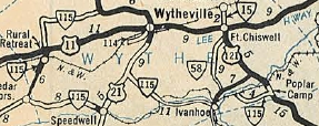
In Aug 1928, VA 115 was renumbered as part of VA 106. Today it is VA 160 and the last bit of VA 68. VA 115 #2: Appeared Aug 1928 as new primary routing, running from Cedar Springs east to US 21/VA 26 (now SR 684) Speedwell, then duplexed with US 21/VA 26 northeast 5 miles (all SR 684 now), then east as new routing 6.94 miles to about Huddle. In June 1930 (CTB), a second piece of VA 115 appeared from US 11/VA 10 south through Rural Retreat to today's SR 677. In 1932, VA 115 replaced VA 116 from Austinville to US 121/VA 15 (now SR 719) Poplar Camp. In July 1932 (CTB), the two pieces of VA 115 were connected as an upgrade to CR 11. Also in July 1932, a new piece of VA 115 was born, running from US 21/VA 26 near Favonia, southwest 3.84 miles towards Rural Retreat. In July 1933, Cedar Springs north through Rural Retreat plus the separate piece to Favonia became VA 90 and Cedar Springs through Speedwell and east towards Austinville plus the Austinville-Poplar camp piece became VA 91. Today, this is SR 680; VA 90; SR 749; SR 684; SR 690; a bit of SR 619; VA 69. VA 115 was shown erroneously as continuous from US 11 northeast to US 21 near Rural Retreat on the 1932 official.
|
|||||
| |||||||||
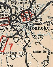
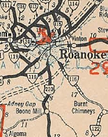
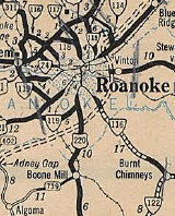
| ROUTE LOG VA 122: 0 - 0 Roanoke-Franklin Line: 9.50 - 9.50 Roanoke City-Roanoke Line: 3.28 - 12.78 VA 24: 2.80 - 15.58 US 220 Bus SB, US 221 SB: 0.14 - 14.72 US 11 SB: 0.14 - 14.86 I-581 (exit 5), US 220, END US 220 Bus: 0.30 - 15.16 US 11 NB, BEGIN US 11 ALT, US 221 NB, US 460 EB, VA 220 ALT NB: 0.50 - 15.66 I-581 (exit 4), US 220, VA 220 ALT END: 0.24 - 15.90 US 11 ALT SB, US 460 WB: 2.31 - 18.21 VA 101: 1.45 - 19.66 |
Creation: Appeared in July 1933 as a renumbering of VA 206. It ran from VA 311 (now SR 863) Hanging Rock southeast through Roanoke to the Franklin County Line. This is the 4th VA 116.
Adjustments: In Aug 1936 (CTB), VA 116 was extended 4.08 miles into Franklin County. In Sept 1937 (CTB), VA 116 was extended to VA 122 Burnt Chimney as an upgrade to SR 670.
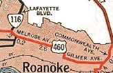
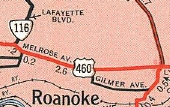
In 1950, VA 116 was rerouted in Roanoke to its current Orange Ave routing - originally it used Melrose Ave, 11th St and Gilmer Ave east to US 11-220 Commonwealth Ave.
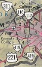
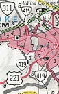
In 1953, VA 116 north was extended over what had been VA 311 across Mason Creek to the new VA 311 alignment. In March 1961 (CTB), VA 116 was placed on modern JAE Valley Rd in the Blue Ridge Pkwy area, leaving behind Mt Pleasant Blvd (now cutoff by BRP) plus abandoned routing SE of Sterling Rd. In May 1966 (CTB), VA 116 was rerouted to cross I-81 at the VA 419 interchange, leaving behind some of Loch Haven Dr In Dec 1968 (CTB), VA 116 was truncated to and replaced by VA 419 from the I-81 interchange to VA 311.
In Jan 1967 (CTB), VA 116 was rebuilt in several places in Franklin County, leaving behind SRs 972, 973, 974, 975. In June 1969 (CTB), VA 116 north was truncated to VA 101, leaving behind SR 780. This was a mileage exchange to create current VA 101. See scan under VA 101 entry. Also in June 1969, Franklin County requested VA 116 be extended south over SR 670 to VA 40 near Union Hall. Improvements: Paved upon designation from Hanging Rock trhough Roanoke VA 116 was paved to the BRP location in 1934. VA 116 was paved from VA 122 north a couple miles in 1938. The rest of VA 116 was paed in 1939. The first portion of VA 116 to be multiloaned was from 11th Ave east to US 11, in 1963. The Jefferson Ave/Williamson Rd is shown as multilane starting in 1988 but I'm pretty sure it was multilaned before that. Posting: Fully posted; a cutout still existed NB between US 11A-460 and VA 101 as late as 2008. Multiplexes: US 220 Bus, US 221 (0.14 mi) US 11, US 220 Bus, US 221 (0.80 mi) US 11 ALT, US 460, VA 220 ALT (0.24 mi) US 11 ALT, US 460 (2.31 mi) Legislative names: Jubal Anderson Early Highway, entire route (since 10/15/53); William Pearce Hunter Memorial Bridge over railroad tracks in downtown Roanoke (since 8/9/56) Other names: Jae Valley Rd/Mt Pleasant Blvd (Roanoke County); Riverland Rd/Piedmont St/Walnut Ave/Jefferson St/Williamson Rd/Orange Ave/Melrose Ave/Lafayette Blvd/Cove Rd (City of Roanoke) Scenic Byway: No segments Comment: VA 116 is blown off by the Blue Ridge Pkwy and also I-581 in southern downtown. The mountain crossing into Franklin County is short but gnarly. VA 116 has a lot of turns in Roanoke and its duplexing nature seems excessive just to keep the bit on Lafayette and Cove in the primary system. The 1939 VDOT report on primary system development had recommended that VA 116 be decommissioned from Burnt Chimney to Roanoke. | ||||||||
| Previous VA 116's:
1928 ROUTE LOG US 411, VA 10: 0 - 0 VA 11: 23 - 23 1930 ROUTE LOG VA 12: 0 - 0 VA 118: 3 - 3 END VA 116: 4.4 - 7.7 1932 ROUTE LOG US 121, VA 15: 0 - 0 CR 10-112: 3.5 - 3.5 |
VA 116 #1: Appeared in May 1923 (CTB) in two pieces: new primary
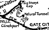
routing from VA 11 (now US 23 Bus) Big Stone Gap southeast 6 miles via
East Stone Gap. Also, replacing VA 10 SPUR from VA 10 (current SR 600) Clinchport north 2 miles towards Natural Tunnel.
In Jan 1925 (CTB), VA 116 was extended 4.5 miles into Lee County. The 1926 Official shows and describes on its route log that VA 116 is fully complete between Clinchport and Big Stone Gap. I cannot find CTB references for 10 of the miles. I have a feeling the State Legislature assigned some of this routing in 1922 or 1923. In Aug 1928, VA 116 was renumbered as VA 106. Today it is US 23-58-421; SR 872, SR 871, SR 864, SR 856; mainly US 23 up to Ironton (used SR 867 and 868 loops; SR 846 loop; SR 844); SR 609 to East Stone Gap; SR 613 over to Big Stone Gap VA 116 #2: Appeared Aug 1928 as a renumbering of VA 121 from VA 12 (now VA 94-274 jct) to Providence Church, then new routing north to Fries. In Aug 1929 (CTB), VA 116 was extended 0.75 miles. In Dec 1930 (CTB), VA 116 was renumbered as VA 58. Today it is the VA 94 corridor which has been largely rebuilt south of Fries. VA 116 used SRs 815 and 816 among alignments still open. VA 116 #3: Appeared Dec 1930 (CTB) as new routing, running from US 121/VA 15 (now SR 719) Poplar Camp west to Austinville. In 1932, VA 116 was renumbered as part of VA 115. Today it is VA 69.
|
||||||||
| |||||
| ROUTE LOG US 11: 0.00 - 0.00 US 11 ALT, US 460: 2.34 - 2.34 VA 101: 0.46 - 2.80 I-581 (exit 2), US 220: 2.24 - 5.04 Roanoke County-Roanoke Line: 0.82 - 5.86 VA 118: 0.20 - 6.06 US 11: 1.15 - 7.21 |
Creation: Appeared in July 1933 as a renumbering of VA 208 from either US 11 College Ave or VA 311 (now Craig St) Salem to US 11 northeast of Roanoke. This is the 4th VA 117.
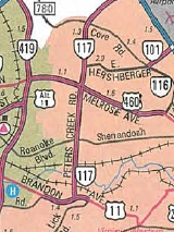
Adjustments: On 1/1/1947 (per Virginia Hwy Bulletin), VA 117 was truncated to Melrose Ave, replaced by US 460. In May 1966 (CTB), VA 117 was placed on new alignment northeast of Roanoke Airport, leaving behind Barns Ave and an extended VA 118. This may have actually happened as early as 1962 as officials show multilaning on the entirety of VA 117. See scan under VA 118 entry. In Sept 1998 (CTB), VA 117 was extended south to US 11 as new construction.
Improvements: VA 117 was paved upon designation Starting with the 1962 mainside of the Official, VA 117 is shown as multilane Posting: fully posted; note that VA 117 was still posted at the US 11-460 split in downtown Salem through at least 1965 Multiplexes: None Legislative names: None Other names: Peters Creek Rd Scenic Byway: No segments Comment: VA 117 provides a bypass of sorts of Roanoke and it is surprising this wasn't a part of US 11 in some way. | ||||
| Previous VA 117's:
1926 ROUTE LOG VA 11: 0 - 0 WV STATE LINE: 2 - 2 1928 ROUTE LOG VA 11: 0 - 0 WV STATE LINE: 4.9 - 4.9 GAP IN ROUTE WV STATE LINE: 0 - 4.9 END VA 117: 0.4 - 5.3 1932 ROUTE LOG VA 12: 0 - 0 VA 47: 1.5 - 1.5 NC STATE LINE: 6.2 - 7.7 |
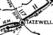
VA 117 #1: Appeared in May 1923 (CTB) as new primary routing,
running from VA 11 (now US 19-460 Bus) Tazewell north to the West
Virginia line at Bishop.
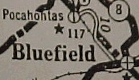
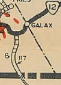
In 1926, VA 117 renumbered as VA 105. Today it is part of VA 16. VA 117 #2: Appeared in May 1926 (CTB) as new routing, running from VA 11 (now US 19) Bluefield north 4.5 miles. In March 1927 (CTB), VA 117 was extended to Pocahontas via today's SR 658. In aug 1928, VA 117 was renumbered as VA 128. Today it is Fairview St in Bluefield north across the RR to SR 802, then SRs 842 and 843; a bit of VA 102; SR 717/643; VA 102 to Pocahontas (except SR 658). VA 117 is misidentified as VA 11 on the 1926 official. VA 117 #3: Appeared in Aug 1928 as new primary routing, running from VA 12 (now US 58-221) Galax south to the NOrth Carolina line near Low Gap. In July 1933, VA 117 was renumbered as VA 96. Today it is a little VA 89 plus SRs 829 and 821 and the lengthy Chesnut Dr in southern Galax.
VA 117Y: Created by Act of General Assembly in March 1940; mentioned in CTB Minutes from 1941-47 as Texas St in Salem. This was not in the 1943 VDOT County atlas but is in the 1946 one. In 1947, VA 117-Y became US 460 ALT and is still that today except it used Lynchburg Turnpike east to Schrader St north in the Mason Creek area.
 VA 117-Y 1946 Roanoke County |
||||
| |||||
| ROUTE LOG US 11: 0 - 0 Roanoke-Roanoke City Line: 1.64 - 1.64 VA 117: 0.20 - 1.84 |
| ||||
| Previous VA 118's:
1928 ROUTE LOG US 19, VA 11: 0 - 0 END VA 118: 16 - 16 CR 6: 5.0 - 11.5 1932 ROUTE LOG US 21, VA 26: 0 - 0 VA 116: 11 - 11 |
VA 118 #1: Appeared in March 1924 (CTB) as new primary routing,
running from Council 6 miles towards Honaker. This was not connected to
any other part of the system.
|
||||
| ||||||
| ROUTE LOG US 58, US 360: 0 - 0 NC STATE LINE: 3.08 - 3.08 |
| |||||
| Previous VA 119's:
1926 ROUTE LOG VA 11: 0 - 0 END VA 119: 3.80 - 3.80 1928 ROUTE LOG VA 1141: 0 - 0 END VA 119: 13 - 13 1932 ROUTE LOG US 23, VA 11: 0 - 0 Lee-Wise Line: 5.35 - 5.35 1964 ROUTE LOG US 220: 0 - 0 US 221 SB: 4.70 - 4.70 US 221 NB: 1.35 - 6.05 US 11 SB: 3.80 - 9.85 US 11 NB: 0.20 - 10.05 US 11 ALT, US 460 ALT: 1.50 - 11.55 |
VA 119 #1: Appeared in April 1924 (CTB) as new primary routing,
running from VA 11 (now US 19-460 Bus) Frog Level southwest to Liberty.
See scan under VA 117 #1 entry.
The Apr 1926 CTB preliminarily extended VA 119 south 5.5 miles but was renumbered as VA 105 when this action was confirmed in May 1926 CTB. Today it is VA 91. VA 119 #2: Appeared in May 1926 (CTB) as new routing, running from VA 1141 (now VA 83) Pound 4 miles towards Wise C.H. In March 1927 (CTB), VA 119 was extended south 8.7 more miles. In Jan 1928 (CTB), VA 119 was extended south to Wise C.H. In Aug 1928, VA 119 was renumbered as VA 120. Today it is US 23 Bus and SR 693 in Pound; US 23; SR 823; US 23 Bus into Wise. VA 119 #3: Appeared Aug 1928 as new primary routing, running from VA 11 (now Us 23 BUs) near Appalachia west via Exeter to the Lee County Line. In July 1933, VA 119 was renumbered as VA 68. VA 119's eastern end was a good bit south of where US 23 BUs meets VA 68 today. VA 119 went by the convenience station near the VA 68 rarilroad bridge and no longer connects to US 23 Bus.
VA 119 #4: Appeared in July 1933 as a renumbering of part of VA 22. Initially it began at US 311 (now US 220-220 bus jct) south of Roanoke, then followed today's VA 419, then SR 904 to Starkey. VA 119 then used SR 897 over to US 221. VA 119 duplexed with US 221 north to Old Cave Spring Rd, then northwest on today's McVitty Rd which dances with VA 419 a ways. VA 119 followed McVitty to US 11 (just west of current VA 419) then used East Riverside Dr to curl northwest back around to end at US 11 Colorado Ave. See scan under VA 116 entry. In Aug 1960 (CTB), VA 119 was rerouted in Salem. At US 11, VA 119 now duploexed east across the Roanoke River, then was sent north on the new Electric Ave and also replaced a bit of SR 1404 to end at US 11 ALT-460 ALT. Official maps continued to show VA 119 on Riverside Dr through its renumbering in 1964. In Sept 1964 (CTB), VA 119 was renumbered as VA 419.
| |||||
| ||||||
| ROUTE LOG US 1: 0 - 0 I-395 (exit 7): 1.65 - 1.65 VA 244: 1.24 - 2.89 US 50: 0.86 - 3.75 VA 237: 1.38 - 5.13 I-66 (exit 71): 0.10 - 5.13 US 29: 0.83 - 6.06 VA 309: 0.55 - 6.61 VA 123: 2.49 - 9.10 |
Creation: Appeared Oct 1940 (CTB) as a renumbering of VA 9, running generally as it does today. This is the 3rd VA 120.
Adjustments: In May 1953 (CTB), VA 120 was rerouted just north of VA 350 (now I-395) to the current alignment. Up to then it used today's 24th St west to Shirlington Rd north.
In 1964, VA 120 was removed from Old Glebe Rd near Military Rd in northern Arlington County. Old Glebe Rd wasn't removed from the state highway system officially until Apr 1972 (CTB). Improvements: Paved upon designation; VA 120 was multilaned from 21st St to VA 244 in 1951 In 1953, VA 120 was multilaned from S. Glebe Rd to 21st St; also from US 50 to Washington Blvd. In 1954, VA 120 was multilaned from VA 244 to US 50. In 1957, VA 120 was multilaned from Washington Blvd to US 29-211. In 1960 or 1961, VA 120 was multilaned from S. Glebe Rd to Mt Vernon Rd In 1963, VA 120 was multilaned from Mt Vernon Rd to US 1. In 1965, VA 120 was multilaned from US 29-211 to VA 309. In 1968, VA 120 was widened from VA 309 to Williamsburg Blvd In 1974, VA 120 was widened from Williamsburg Blvd to Military Rd The only 2-lane segment left is the northernmost half mile or so. Posting: Fully posted; Multiplexes: VA 237 (0.25 mi) Legislative names: None Other names: Glebe Rd Scenic Byway: No segments Comment: VA 120 essentially splits Arlington County in half. The 2-lane portion is narrow and winding, giving a mountain drive feel in the midst of suburbia. VA 120 is blown off by George Washington Mem Parkway, though in fairness an interchange there would've been a challenge to build as the parkway is way above VA 120. Not sure why VA 120 isn't numbered VA 238 as part of a 9-238 swap. Even weirder is that VA 120 ends at VA 123 which makes a turn to access the chain Bridge to Washington. |
|||||
| Previous VA 120's:
1932 ROUTE LOG US 23 SB, VA 11, VA 10: 0 - 0 VA 121 EB: 17 - 17 VA 121 WB: 0.5 - 17.5 KY STATE LINE: 4.5 - 22 1943 ROUTE LOG VA 40: 0 - 0 SR 602-640: 13 - 13 |
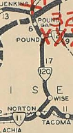
VA 120 #1: Appeared Aug 1928 as a renumbering of VA 1141 from the Kentucky Line to Pound; VA 119 from Pound to Wise C.H.; new routing from Wise C.H. to VA 11 (now VA 74) Norton.
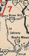
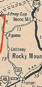
In 1931, US 23 was assigned to the entirety of VA 120. In July 1933, VA 120 was dropped from the route. Today it is US 23; SR 867; US 23; US 23 Bus; SR 693; US 23; SR 823; US 23 Bus through Wise CH; SR 757; US 23 Bus to Norton. VA 120 #2: Appeared in July 1933 as a renumbering of VA 219 as a two-piece route: VA 40 Ferrum north to SR 640 and from US 311 (now US 220) Boones Mill west 5 miles. The Boones Mill piece disappeared from official maps in 1937 and is not on the 1936 Franklin County Map. This is now SR 739. In Oct 1940 (CTB), the Ferrum piece was renumbered as VA 245. Today it is SR 602.
| |||||
Previous: VA 81 - 100 |
Next: VA 121 - 140
Top | Virginia Hwy Index
Home
Page last modified 27 March 2022


