Previous VA 11's:
1932 ROUTE LOG
US 411, VA 10: 0 - 0
US 23 SB, VA 106 SB: 18 - 18
VA 119: 2.5 - 20.5
VA 106 NB: 0.5 - 21
VA 133: 5 - 26
US 23 NB, VA 120: 7 - 33
VA 122 NB: 9.5 - 42.5
VA 122 SB: 0.5 - 43
VA 123 NB: 14 - 57
VA 123 SB: 3 - 60
VA 107: 7 - 67
VA 110: 1 - 68
US 19 SB, VA 131: 9 - 77
VA 111 SB: 8 - 85
VA 111 NB: 3 - 88
VA 126: 14 - 102
VA 112 SB: 13 - 115
VA 112 NB: 3 - 118
VA 127 EB: 1 - 119
VA 127 WB: 1 - 120
VA 128 NB: 18.5 - 138.5
VA 128 SB: 0.5 - 139
WV STATE LINE: 1 - 140
|
|
VA 11: Created by the General Assembly in January 1918:
West Virginia Line, Graham, Tazewell, Rosedale, Lebanon, Old Court House, St. Paul, Coeburn, Norton, Big Stone Gap, Pennington Gap, Cumberland Gap; SECONDARY LINE: Coeburn to Clintwood, Kentucky Line; Clintwood to Grundy
Here is a look at the original VA 11 from a geographical standpoint using current route numbers as a guide.
Cumberland Gap to Woodway
VA 11 originally began at the Tennessee State Line within the Cumberland Gap Historical Park, where US 25E's south exit from Virginia was originally located. VA 11 was 100% duplexed with VA 10 from there to Woodway.
VA 10-VA 11 followed what is now a restored trail through the Cumberland Gap Historic Area. It used SR 872, then an unnumbered road that parallels the modern US 58 to the north eastward. The route used the SR 912 loop, then maybe modern US 58 but there is what looks like an old alignment on satellite photo that is not a road today.
VA 10-VA 11 used SR 732 through the old Gibson Station area, then the piece of SR 692 that is north of US 58. THe route may have followed modern US 58 over to Wheeler, then SR 729. The route then seems to have followed modern US 58 to Kesterson Mill.
VA 10-VA 11 followed SR 684 routing south of US 58, but not north of it unless it was before 1927. The route followed US 58 BUsiness through Ewing. The route likely used SR 697 and SR 672 to go to Rose Hill.
VA 10-VA 11 followed modern US 58 until SR 670, then used the SR 813 loop to Henegartown. The route used a small bit of SR 621 and all of SR 814 in the Russels Store area. Continuing east the route used SR 946 (except used the SR 815 loop), then SR SR 899 and SR 880 down to Cony Hollow.
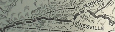
VA 10-VA 11 followed modern US 58 from here to Jonesville except used the SR 836 and SR 745 loops. Then the route followed US 58 ALT north of Jonesville to Ben Hur except it likely used SR 715, 716, and 760, plus it looks like some alignments have been destroyed.
In Ben Hur the route likely used some SR 645 and SR 644 then modern 58 ALT to Sulphur Springs, where the route probably used Combs Rd to Pennington Gap. The route in Pennington Gap seems to have been modern 58 ALT, then US 421 south of town. The route then seems to have used a bit of SR 630 plus a dead end alignment back to US 421. The route used SR 785 into Woodway.
In early 1922, VA 11's legislative definition added "Kentucky Line" after Cumberland Gap. What this apparently meant was that VA 11 was extended west by itself (VA 10's definition did NOT change) to the Kentucky State line heading for Middleboro. This road already existed and was well constructed as a project by the Federal Government, opening in Oct 1908 as Government Pike. Evidently this road was transferred to state controls around 1922.
In 1923, the Government Pike part of VA 11 became a rerouted VA 10 while the rest of the VA 11 segment to Woodway dropped the VA 11 designation and remained part of VA 10.
VA 11 duplexed with VA 10 Cumberland Gap to Woodway
Woodway to Bluefield, WV.
VA 11 followed today's SR 642 northeast to US 58 ALT, then followed US 58 ALT east to Big Stone Gap except it used Dacota Ave in the Cadet area.
In Big Stone Gap VA 11 turned north on US 23 Business. VA 11 used US 23 Business through Appalachia except it used Callahan Ave around where VA 78 ends today. VA 11 continued east on 23 Business to Dorchester, then followed SR 790 through Dorchester Junction which turns into Main Ave SW in Norton.
|
|
VA 11's old westbound look in Norton |
VA 11 followed Main Ave to 12th St SW (not current SR 619 which was rerouted for the interchange with 23 Bypass nearby). Then north on SW 12th to Park Ave NW. VA 11 headed east on Park, then followed today's VA 74 out of Norton. At the Laurel Grove Cemetery VA 11 switched to Ramsey Rd to get over to US 58 ALT.
|
VA 11 followed Main Ave to 12th St SW (not current SR 619 which was rerouted for the interchange with 23 Bypass nearby). Then north on SW 12th to Park Ave NW. VA 11 headed east on Park, then followed today's VA 74 out of Norton. At the Laurel Grove Cemetery VA 11 switched to Ramsey Rd to get over to US 58 ALT.
VA 11 used 58 ALT, then SR 762 Matthews Rd, then 58 ALT, then likely SRs 688-798 through Tacoma, a smidge of 58 ALT, then SR 813 Old Norton-Coeburn Rd. VA 11 followed VA 158 through Coeburn.
East of Coeburn, VA 11 used SR 893 Bull Run Rd, then back onto US 58 ALT. VA 11 followed 58 ALT for the most part to St. Paul except it used the Bull Hill Rd loop near Burtons Ford.
East of St. Paul, VA 11 seems to have followed pretty much 58 ALT down to just short of VA 65, where it cut east on Memorial Drive, SR 683. VA 11 used SR 683 back down to 58 ALT. VA 11 stuck with US 58 ALT except for SRs 836 and 715, then used VA 71 east to Lebanon.
In Lebanon, VA 11 turned onto Old Fincastle Rd (just short of US 19 Bus) and followed that to the US 19 Bus-VA 82 jct. Then VA 11 followed US 19 Bus to its north end before picking up on SR 656 paralleling US 19. Once SR 656 crosses US 19, VA 11 followed US 19 more or less past Elk Garden.
In the Rosedale area, some of the original VA 11 still exists parallel and just north of US 19, especially where VA 80 crosses. VA 11 followed US 19's corridor (it appears the actual VA 11 path remains north and parallel on abandoned alignments) until SR 609, then VA 11 used SR 609 through Belfast Mills to Maiden Spring, then VA 91 northeast through Liberty to US 19-460 Business. The routing from Belfast Mills to Tazewell is confirmed in the Oct 1921 (CTB).
VA 11 followed US 19-460 Business through central Tazewell, but at VA 16 ALT used Old Fincastle Tpke. It is uncertain the exact routing of VA 11 through central Tazewell as there are some options.
Past central Tazewell, VA 11 veered southeast onto Ben Bolt Ave to cut over to VA 61. Then VA 11 followed VA 61 north to Riverside Dr. VA 61 turns left and VA 11 turned right, following Market St SR 678 north to SR 645, then east to connect back up (may not be possible today) with US 19-460.
VA 11 followed the US 19-460 corridor eastward, though there are a number of SR loops now that have been created by the 4-laning of the modern route. VA 11 picked up US 19 heading into Bluefield. It looks like VA 11 followed today's US 19 through Bluefield to the West Virginia line, though it is possible VA 11 initially cut underneath the tracks via the 1890 underpass and crossed into WV on the north side of the tracks.
In Dec 1921 (CTB), VA 11 was rerouted from Rosedale to North Tazewell via Claypool Hill, by using US 19's corridor, then VA 11 followed SR 770 Ascue Rd over to SR 609 Wardell. VA 11 cut north on SR 609 back to US 19.
VA 11 followed US 19 to Claypool Hill except used SR 705 through Steelburg. VA 11 followed US 19-460 to Pounding Mill, then veered onto SR 637 Limestone Rd running north of 19-460 through Cliffield. VA 11 picked back up US 19-460 and followed to SR 632 and VA 16 ALT to VA 16 southbound to pick back up original VA 11 northeast of Tazewell.
By 1923, VA 11 was rerouted to go through Tazewell again, using US 19-460 Business and Fincastle Tpk as described earlier.
In 1927, US 19 was co-signed with VA 11 from Lebanon to Bluefield.
In July 1933, VA 11 was renumbered to VA 64 from Woodway to Lebanon and remained US 19 from Lebanon to Bluefield.
|
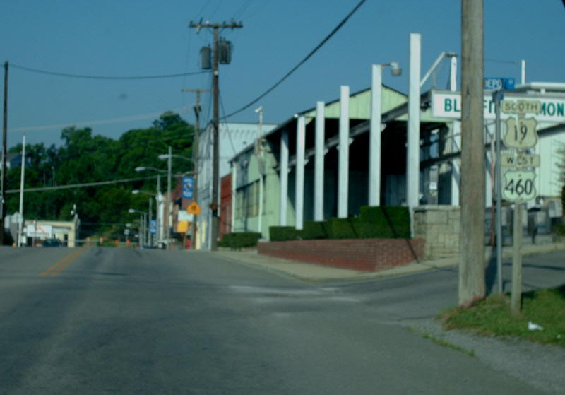
VA 11's old westbound approach into Bluefield
|
VA 11 SPUR #1: Defined in 1918 to run from VA 11 (now VA 158) Coeburn north to near Clintwood, then north via SR 611 towards the Kentucky State line. It is uncertain if/how it actually reached the state line from Isom.
In Feb 1922 (CTB), VA 11 SPUR #1 was rerouted at Georges Fork to instead head west to Kentucky via Pound. Georges Fork to Clintwood became part of VA 11 SPUR #2.
In 1923 this became part of VA 114 and VA 1141. Today it is the VA 72, VA 83 and US 23 corridors.
VA 11 SPUR #2: Defined in 1918 to run from Clintwood to Grundy, using the current VA 83 and VA 63 corridors.
In Dec 1921 (CTB), VA 11 SPUR #2 east was truncated to Fremont.
In Feb 1922 (CTB), VA 11 SPUR #2 west was extended over VA 11 SPUR #1 from Clintwood to Georges Fork. VA 11 SPUR #2 east was re-extended to Haysi.
In Oct 1922 (CTB), VA 11 SPUR #2 became VA 11Z.
VA 11 SPUR #3: Appeared in Dec 1921 (CTB) as a connection from VA 11 (now US 19) Claypool Hill to Grundy via Raven.
By March 1923 (CTB), VA 11 SPUR #3 was being called VA 11X. Today it is the US 460 corridor.
VA 11 SPUR #4: Appeared in Dec 1921 (CTB) as a short connection between VA 11 (now VA 61) North Tazewell south to Tazewell.
In 1923, VA 11 SPUR #4 became part of VA 112. Today it is part of VA 16.
VA 11X: Appears in the March 1923 CTB Minutes as the route from Grundy to Hangar (now Oakwood), which was VA 11 SPUR #3 previously. This shortly became part of the original VA 111. and today is the US 460 corridor in this area.
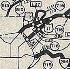
VA 11Y: Appears July 1933 as a replacement for US 11-VA 33 in Downtown Staunton, running on N. Augusta Ave from VA 5 (now US 250) northeast to US 11 (just Coalter St). VA 11Y was renumbered as mainline US 11 in July 1936 and today is part of US 11 Business.
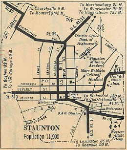
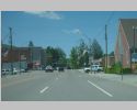
US 11 on Augusta St.
|
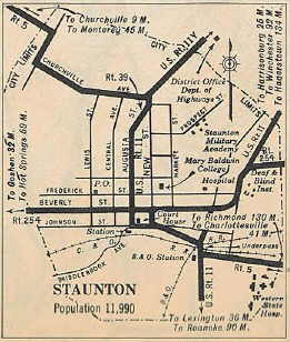
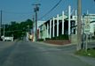
VA 11Y on Augusta St.
|
US 11 returns to Augusta St.
|
VA 11Z: Appears in October 1922 CTB minutes as the designation for the route between Clintwood and Fremont, which had been VA 11 SPUR #2. In 1923 this was renumbered as part of VA 114. Today this is part of the VA 83 corridor.
|