< US 219 | Home | US 220 ALT | US 221 >
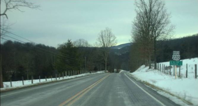
Photo: A quiet and snowy US 220 nearing West Virginia (photo by Mapmikey 1/11/10)
|
|
|
| ROUTE LOG |
NC STATE LINE: 0 - 0 US 220 Bus: 3.05 - 3.05 VA 87: 0.70 - 3.75 US 220 Bus: 0.61 - 4.36 US 58 EB, US 220 Bus: 2.35 - 6.71 US 58 WB, US 58 Bus: 3.49 - 10.20 VA 57 ALT: 6.42 - 16.62 VA 57 EB: 0.80 - 17.42 US 220 Bus, VA 57 WB: 0.77 - 18.19 Franklin-Henry Line: 5.82 - 24.01 US 220 Bus: 12.26 - 36.27 VA 40: 3.18 - 39.47 US 220 Bus: 1.35 - 40.82 Roanoke-Franklin Line: 10.56 - 51.38 Blue Ridge Pkwy: 6.07 - 57.45 Roanoke City-Roanoke Line: 0.39 - 57.84 US 220 Bus, VA 419: 1.64 - 59.48 I-581 BEGIN, VA 24: 3.37 - 62.85 US 11, US 220 Bus, US 221, VA 116: 0.66 - 63.51 US 11 ALT, US 460, VA 116, VA 220 ALT: 0.31 - 63.82 VA 101: 2.79 - 66.61 VA 117: 1.75 - 68.36 Roanoke-Roanoke City Line: 0 - 68.36 I-81 SB (exit 143), END I-581: 0.84 - 69.20 VA 115: 2.34 - 71.54 Botetourt-Roanoke Line: 0.84 - 72.38 I-81 NB (exit 150), VA 220 ALT: 3.27 - 75.65 VA 43: 22.21 - 97.86 Alleghany-Botetourt Line: 10.83 - 108.69 US 220 Bus: 1.54 - 110.23 US 60 Bus WB: 0.61 - 110.84 I-64 EB (exit 27), US 60 EB, US 60 Bus END: 0.66 - 111.50 US 60 Bus, US 220 Bus, VA 384: 3.47 - 114.97 I-64 WB (exit 17): 7.32 - 122.29 Covington-Alleghany Liine: 0.62 - 122.91 VA 18: 0.46 - 123.37 US 60 WB: 0.38 - 123.75 Alleghany-Covington Line: 2.21 - 125.96 Bath-Alleghany Line: 9.89 - 135.85 VA 39 WB: 12.92 - 148.77 VA 39 EB: 0.19 - 148.96 Highland-Bath Line: 13.84 - 162.80 VA 84: 12.09 - 174.89 US 250: 3.89 - 178.78 WV STATE LINE: 7.61 - 186.39
|
Creation: US 220 appeared in Virginia in September 1934 (AASHO), running generally as it does now as a replacement for US 311 from North Carolina to Roanoke; added to US 11 from Roanoke to Troutville; replaced VA 12 from Troutville to Clifton Forge; added to US 60 from Covington to Clifton Forge; replaced VA 18 from Covington to West Virginia.
|
Adjustments:In Oct 1935 (CTB), US 220 was rerouted at Hollins to follow a bit of VA 114 to Daleville, then upgraded routing of SR 671 and new construction for a more direct route to Fincastle. The old route to Troutville remained part of US 11 and Troutville northwest to the new US 220 became VA 294 (now SR 670).
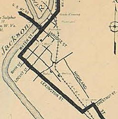
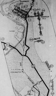
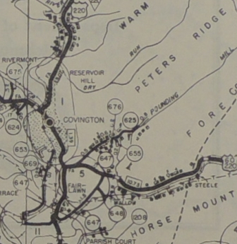
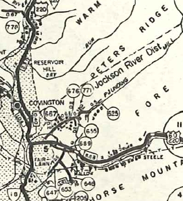
About 1936 (RR bridge date), US 220 was removed from Chestnut/Lexington/Water Sts in Covington and instead used Highland/McDonald/Locust/Magazine to Riverside In 1937, US 220 was rerouted in Clifton Forge to use the A Street bridge utilized by today's US 220 Business and US 60 into downtown. Previously, US 220 left US 60 via River Rd south then east along what is now not a public road then across the railroad tracks before using a covered bridge that was immediately adjacent to the current bridge. In May 1938 (CTB), US 220 was straightened out on 31 segments from Monterey to Mustoe in Highland County. In Sept 1940 (CTB), US 220 was rerouted out of the north of Martinsville to use today's US 220 Business through Collinsville. The old routing remained VA 57. Between 1939-44, US 220 was removed from McDonald/Locust/Magazine in Covington to use Highland/Bridge/Riverside Between 1945-49, US 60-220 was placed on new alignment east of VA 18, leaving behind SR 689 (now cut off by I-64...today it is a little stub E. Echols Rd; SR 689/647 Interstate Dr; destroyed by 64 on the eastern end). In April 1947 (CTB), US 220 was removed from Riverside St in Covington as well as US 60 on Mornoe Ave and instead placed on Allegany Ave and SR 1502 just outside Covington's NCL.
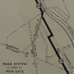
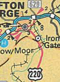
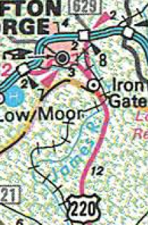
In June 1947 (CTB), US 220 was rebuilt in the area now bisected by the Blue Ridge Pkwy, leaving behind a lengthy SR 789 (today this is SR 674 Clearbrook Ln; SR 766 Stable Rd; a small bit of the US 220 access road to the BRP; SR 789 Old Rocky Mt Rd). Between 1945-49, US 220 was given its current routing through Iron Gate. Previously it used SR 1707 Commerce St and SR 1703 5th St to cut over to Market St.
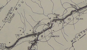
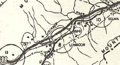
About 1953, US 60-220 was put on what is now I-64's footprint bypassing Low Moor and Selma, leaving behind SR 696.
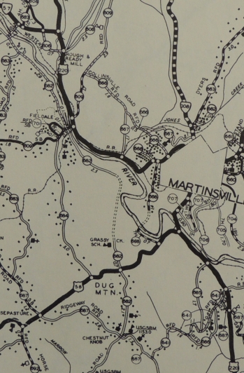
In March 1955 (CTB), US 220 was placed on Memorial Drive in Martinsville. The old routing remained parts of US 58 (now 58 Bus) and VA 57 (now VA 457).
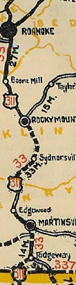
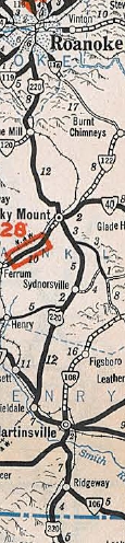
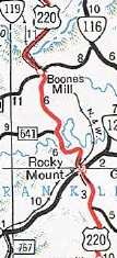
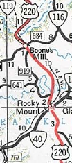
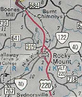
In Nov 1955 (CTB), US 220 was rebuilt between Rocky Mount and Boones Mill mostly as new construction but did use some existing SR 710 near Rocky Mount and some SR 697 near Wirtz. The old route became SR 919, which actually has climbing lanes near its south end. In Sept 1961 (CTB), US 220 was placed on a new freeway bypass of Rocky Mount, leaving behind US 220 Business. The bypass had been called US 220 ALT throughout the construction period and official maps label it that way through much of the 1960s.
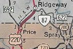
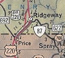
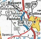
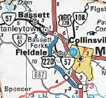
In April 1963 (CTB), US 220 was placed on a new western bypass of Ridgeway, leaving behind US 220 Business.
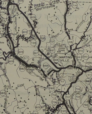
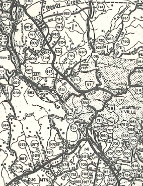
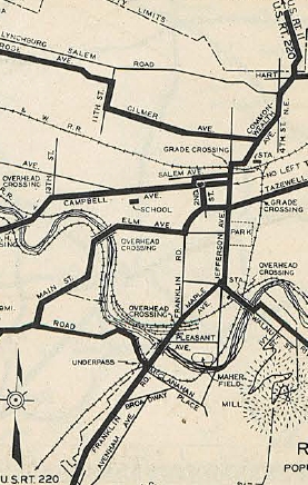
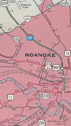
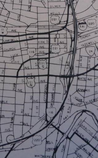
In 1965, US 60-220 was removed from SR 1104 Valley Ridge Rd east of Covington and placed onto the new I-64. Note that US 60-220 always crossed the Jackson River essentially where I-64 does now, and not where SR 1101 Winterberry Ave does by Alleghany High School. I-64 was built directly on top of US 60-220 from the Jackson River bridge east to the US 60-220 Bus/VA 384 exit west of Clifton Forge. Also in 1965, US 220 was removed from US 11 between US 11 ALT/460 Roanoke and Daleville and instead placed onto I-81 and I-581. Or was it? The 1966 Official shows this. The '67 shows neither routing as US 220. '68 and '69 show US 220 following US 11. 1970 and later show US 220 on I-581. US 220 may have been added to I-581 from Orange Ave to Williamson St in 1967. At any rate, US 220 used to meet US 11 directly opposite of today's SR 811 and not today's VA 220 ALT. The 0.07 miles between I-81 Exit 150 and US 11 became F049 once US 220 was placed onto I-81. About 1975, US 220 was added to I-581 from Williamson Ave to VA 24, then southward on newly constructed freeway to Franklin Rd just south of Downtown. Per the 1975 VDOT City map of Roanoke the old routing south of VA 116 was removed from the primary system, but I have a 1975 picture that shows US 220 Business was signed through Downtown Roanoke. In Aug 1975 (CTB), US 220 was removed from SR 958 Dunahoo Dr at the Roanoke/Franklin line. In July 1976 (CTB), US 220 was placed on a small bit of VA 57, then newly constructed freeway around the west side of Martinsville, then placed onto US 58 east back to the previous routing. The old route through Collinsville and central Martinsville became US 220 Business. In Nov 1977 (CTB), US 220 was extended along more new freeway to the southwest of Martinsville to its current routing. The old route east to US 220 Business remained part of US 58 (now US 58 Business).
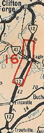
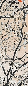
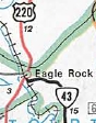
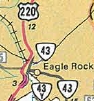
In 1979, US 220 was put on a new bypass of Eagle Rock, leaving behind VA 43Y (now SR 870) and an extended VA 43.
In Dec 1980 (CTB), US 220 was placed on newly constructed freeway from Franklin Rd Roanoke south to VA 419. The old route became US 220 Business. See scan under the US 220 Business entry for Roanoke.
Around 1986, US 220 was put on new construction north of Iron Gate, then added to US 60 Bus east to I-64/US 60 west to bypass Clifton Forge. The old route became US 220 Business.
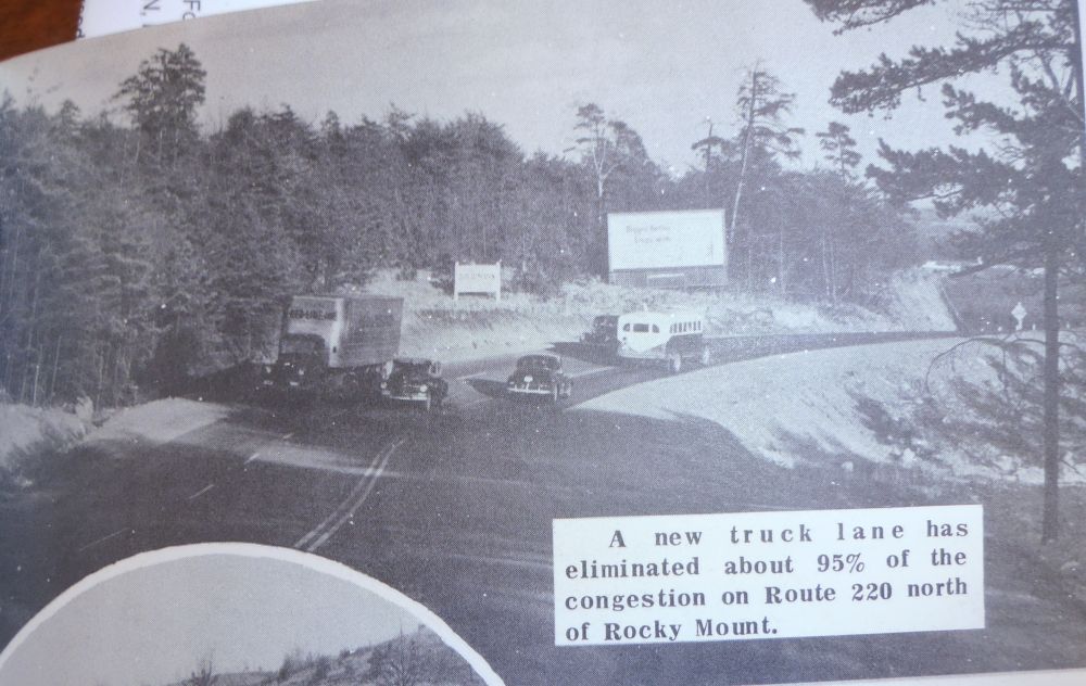
Improvements: Upon designation, US 220 was fully paved except for today's VA 84 south to Bath County Line. By 1938, US 220 was paved everywhere. The earliest multilaning of US 220 was by 1941, on the northernmost mile of its US 11 duplex. In 1951, US 220 was multilaned from Covington to halfway to Clifton Forge. In 1953, US 220 was multilaned from Boones Mill to Roanoke (except SR 958) and also right in Rocky Mount. In 1954, US 220 was multilaned on the new Selma-Low moor Bypass. In 1958, US 220 was widened from the NC line to just short of Ridgeway. In 1959, US 220 was widened from Bassett Forks to Collinsville. In 1960 or 1961, US 220 was multilaned on its US 58 Duplex and up to Collinsville; also from US 60 to the NCL of Covington. In 1962, US 220 was multilaned from VA 117 to SR 605. In 1964, US 220 was multilaned on a short segment south of Sydnorsville. In 1965, US 220 was multilaned when added to I-81 and I-581. In 1966, US 220 was multilaned from US 58 south to the north end of the Ridgeway bypass. In 1967, US 220 was multilaned from Bassett Forks to the Franklin County Line. In 1969, US 220 was multilaned from Franklin/Henry line to the Sydnorsville segment; south end of Rocky Mount bypass a couple miles. In 1970, US 220 was multilaned between the two segments described in 1969; also from the north end of the Rocky Mount bypass to Boones Mill. In 1971, US 220 was multilaned on the Ridgeway and Rocky Mount Bypasses; also from I-81 north 3 miles. About 1972, US 220 was placed on one-way splits through downtown Clifton Forge. In 1974, US 220 was multilaned up to Fincastle from the 1971 segment. In 1976, US 220 was multilaned from Fincastle to the southern SR 655 junction. In 1979, US 220 was multilaned on a segment south of Eagle Rock In 1981, US 220 was multilaned from SR 655 to SR 635. In 1985 or 1986, US 220 was multilaned from SR 635 northward. In 1986, US 220 was multilaned when added to I-64 around Clifton Forge. In 1990, US 220 was multilaned on the gap between the 1979 and 1985-86 segments. Posted: Fully posted; Cutouts and a vintage white border sign were removed from Covington between 2018-21; Bath County cutouts removed between 2009-15; Highland County cutouts remain as of 2015 Multiplexes: US 58 (3.49 mi) VA 57 (0.77 mi) I-581 (6.35 mi) I-81 (6.45 mi) US 60 Bus (0.66 mi) I-64, US 60 (10.79 mi) US 60 (1.46 mi) VA 39 (0.19 mi) Legislative names: William F Stone Highway, Martinsville Bypass (10-25-73); Roy L Webber Highway, VA 419 to Elm Ave (2-16-78) Charles Carter Lee Memorial Bridge over VA 40 (10-3-60) Other names: Greensboro Rd (s of US 58); Virginia Ave (Va 57 to Franklin Co line); Virgil H Goode Hwy (Franklin Co); Franklin Rd (Roanoke Co s of VA 419); Roanoke Rd (I-81 to Fincastle); Botetourt Rd (Fincastle to Iron Gate); Market Ave (Iron Gate to US 60 Bus); Madison St/Alleghany Ave (Covington); Hot Springs Rd (Alleghany Co n of Covington); Ingalls Blvd (Bath Co s of Warm Springs); Stuart Hwy (Bath Co n of Warm Springs); Jackson River Rd (Highland Co s of Monterey); Potomac River Rd (n of Monterey) Scenic Byway: no segments Comments:US 220 south of Covington is mostly very modern, 4-lane used for through traffic. Below Roanoke US 220 is in the general corridor of I-73 if it comes to pass. Tony Payne reports in August 2005: If you drive on US 220 south from Roanoke to Rocky Mount, there's a "To I-40" sign right before you reach VA 40. It's there apparently to prevent motorists from thinking that VA 40 is I-40. There's a sign assembly with a "To", then an I-40 shield (no state name), and a blue sign saying "73 Miles" right underneath the shield (obviously guiding motorists to Greensboro, NC). |
|||||||||||||||||||||||||||||||||||||
Previous: US 219 |
Next: US 220 ALT |US 220 Bus | US 220-Y | US 221
Top | Virginia Hwy Index
Home
Page last modified 5 March 2022