Previous VA 12's:
1932 ROUTE LOG
US 11, US 58 WB, VA 10: 0 - 0
VA 130: 12 - 12
VA 112: 9 - 21
VA 135: 9 - 30
VA 113: 18 - 48
VA 139: 15 - 63
VA 129: 1 - 64
US 21, US 221 SB, VA 26: 12 - 76
VA 58: 11 - 87
VA 117: 6 - 93
BEGIN US 58, US 121, VA 15: 13 - 106
US 221 NB, VA 205: 1 - 107
VA 210: 23 - 130
VA 23 NB: 11 - 141
VA 23 SB: 4 - 145
US 311 SB, VA 33 SB: 29 - 174
US 311 NB, VA 33 NB: 2 - 176
VA 300: 26 - 202
US 29 SB, VA 14 SB, VA 301 SB: 4 - 206
US 58 EB, BEGIN US 360, VA 44: 0.5 - 206.5
US 29 NB, VA 14 NB, VA 301 NB: 0.5 - 207
VA 57: 32 - 239
US 501 SB, VA 18 SB: 3.5 - 242.5
VA 18 NB: 0.5 - 243
US 15, VA 32: 23 - 266
VA 44: 8 - 274
US 58 WB, VA 400: 10 - 284
US 1 SB, VA 31 SB: 12 - 296
VA 434: 5.5 - 301.5
US 1 NB, VA 31 NB: 0.5 - 302
VA 416: 3 - 305
VA 401: 16 - 321
VA 438: 2 - 323
VA 402: 2 - 325
VA 509 NB: 14.5 - 339.5
US 17-1, VA 24, VA 509 SB: 0.5 - 340
VA 35 SB: 26 - 366
VA 35 NB: 2 - 368
US 117, VA 507 SB: 10 - 378
VA 507 NB: 2 - 380
VA 10 EB, VA 505: 19.5 - 399.5
VA 10 WB: 0.5 - 400
VA 10: 3 - 403
VA 539: 7 - 410
VA 10 WB: 8 - 418
US 17 NB, VA 503: 1 - 419
US 17 SB, VA 40: 1 - 420
VA 27: 1 - 421
US 58 EB, VA 10 EB: 2 - 423
VA 502: 5 - 428
US 60 WB, VA 500: 5 - 433
VA 501: 12 - 445
US 58, END US 60, VA 10: 1 - 446
END VA 12: 2 - 448
1935 ROUTE LOG
US 11, BEGIN VA 114: 0 - 0
VA 114 WB: 3 - 3
VA 294: 3 - 6
VA 43: 15 - 21
US 60: 16 - 37
1953 ROUTE LOG
US 11: 0 - 0
US 250 WB: 14 - 14
VA 254: 0.5 - 14.5
US 250 EB: 1.5 - 16
VA 256: 12 - 28
US 33: 16 - 44
US 211: 28 - 72
VA 48: 22 - 94
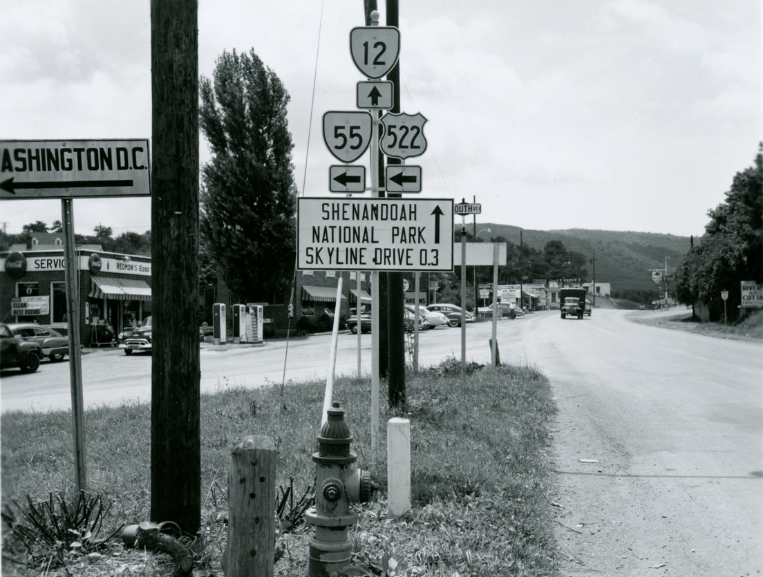
US 522 SB, VA 55 EB: 2 - 96
VA 55 WB: 3 - 99
US 522 NB, VA 277: 9 - 108
US 50, VA 17: 6 - 114
VA 255: 3 - 117
US 340, VA 7: 4 - 121
|
|
The lowest number in Virginia not currently being used is 12. There have been 3 previous VA 12's:
VA 12 #1: Created by the General Assembly in January 1918:
Virginia Beach, Norfolk, Suffolk, Franklin, Courtland, Emporia, Lawrenceville, South Hill, Chase City, Houston, Danville, Martinsville, Stuart, Hillsville, Galax, Independence, to a point near Damascus, to connect with Route 10 at/near Cedarville; Connection: North Carolina Line, Hillsville, Wytheville
Here is a look at the original VA 12 from a geographical standpoint using current route numbers as a guide.
Cedarville to Independence
VA 12 originally began at VA 10 (now US 11) Cedarville, then headed southeast over today's SR 803 to south of Lodi, then down SR 803 SPUR (an old VA 91 alignment), then south down VA 91 to Damascus.
The 1923 Official shows VA 12 following today's US 58 east a short distance, then following Orchard Hill Rd across Laurel Creek, which connects with VA 91 east of town. The 1923 Official shows VA 12 running along today's SR 725 to Taylor's Valley, then SR 726 to US 58 to Green Cove. This requires a dip into Tennessee to accomplish between Damascus and Taylors Valley.
In Grayson County VA 12 appears to have followed US 58 to near Rugby, then SR 725 southeast to SR 856 (old VA 16), requiring a brief dip into North Carolina. Then it followed VA 16 back to US 58. There is a small chance it used SRs 725-743-723-722-721 to US 58. In any case, the '23 Official clearly shows VA 12 not following Wilson Creek to Volney.
VA 12 pretty much follwed US 58 from Mouth of Wilson to Independence.
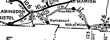
In 1924, VA 12's west end was moved to VA 10 (still US 11) Scotts Addition near Abingdon, then followed US 58 to Damascus except used Celebrity Ln/(no longer connects to) Pewter Ln; Lacy Dr; Minton Ln near Osceola; Old Jeb Stuart Hwy at Osceola; Old Jeb Stuart Hwy at S. Holston River; Drowning Ford Rd near Delmar (but not Alvarado Rd); Blossom/Hollyfield Rds. through Roetown and Valis Mill.
VA 12 then followed VA 91 north to Lodi (used Librty Hall Dr loop), then east on SR 762 to St. Clair Bottom (replaced parts of CRs 4 and 2), then SR 660 to SR 650 which VA 12 followed south to Holston Mill and continued on SR 650 all the way to VA 16 (replaced CR 4). VA 12 then followed VA 16 through Troutdale and probably used SRs 836-739 and SR 737 through the Grants area, then followed VA 16 down to Mouth of Wilson.
The former route of VA 12 became VA 125 and CR 39 from Cedarville to Lodi; unknown CR south of Damascus; CR 25 to Taylors Valley; CR 71 to Green Cove; CR 26 to Grayson County; CR 11 to Grassy Creek; unknown to Mouth of Wilson
VA 12 original routing
1923 Official
|
VA 12 rerouted to the north
1924 Official
|
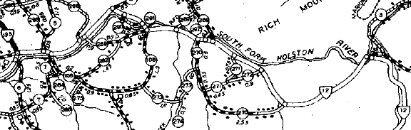
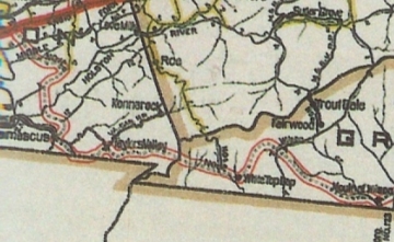
Mystery solved regarding how VA 12 and later US 58 traversed Smyth County
1932 Smyth County
By 1932, VA 12 was removed from SR 715 Blossom Rd near Vails Mills.
In July 1933, VA 12 was renumbered as US 58 from Abingdon to Independence.
Independence to Martinsville:
VA 12 followed US 58-221 east to VA 274, then east on 274 to SR 691 which it followed north partway to SR 692, then east back to VA 274 over what is no longer a road. VA 12 then followed VA 274 to VA 94 south to SR 640 which used to ferry the New River. VA 12 continued on 640 through Old Town to Galax as Greenville Rd, then W. Stuart Dr (makes a 90 degree turn at MacArthur) back to US 58-221 to Glendale Rd out of Galax and on SR 887 out to near Woodlawn before using SR 872 Woodlawn Rd. If VA 12 ever used SR 722 Gladeville Rd it was before 1923.
VA 12 initially followed abandoned routing northeast from Woodlawn Rd's east end to SR 958 Training Center Rd to (route split by I-77) SR 957 Shotgun Rd to SR 714 Old Galax Pike to go from west of Browns Store to go through Hillsville via W. Grayson St, and crossed today's US 52 onto E. Grayson St which used to seamlessly become today's US 58 again at the US 221 split.
VA 12 east of Hillsville followed US 58 for the most part except Retrievers Run/Shatner Rd near Crooked Oak. After crossing Reed Island Creek it appears VA 12 followed Nursery Rd/Calvary Way; Joppa Rd ad SR 646 Cardinal Cir west of Laurel Fork; Old Danville Pike through Laurel Fork and used
SR 632 Maple Shade Rd to get to Floyd County. VA 12 headed southeast back to today's US 58 using SR 620 Tory Creek Rd which used to connect to SR 780 Turnip Patch Rd. VA 12 followed US 58 into Patrick County, where it then used US 58 Business into Meadows of Dan. VA 12 may have used SR 795 Concorde Rd. VA 12 appears to have followed the US 58 descent off the Blue Ridge until near the bottom where it used Greasy Bend Ln.
VA 12 followed today's US 58 and 58 Business into Stuart. East of Stuart, VA 12 followed SR 765 Rhody Creek Loop; US 58; Campbell Farm Loop; US 58; SR 777; US 58; SR 625 Mt. View Loop; US 58; SR 657/827 S. Fork Loop; US 58; SR 700 through Netteridge; SR 832 Golf Course Rd through Trent Store; SR 701/854 Stella Loop to Penns Store;
|
|

US 311/VA 12 crossing of Smith River below Martinsville (circa 1930 post card)
Click for larger version showing two US 311 shields and a VA 12 shield |
In Henry County, VA 12 may have used SR 969 Turnpike Rd/abandoned routing/SR 669 Mayo Landing Rd (but by 1926 it was using SR 630 Log Manor Rd/Maple Leaf Rd); SR 695 Spencer Penn Rd; SR 759 Evergreen Dr; SR 692 Arrowhead Cir; SR 824 Rocky Knoll Rd; SR 875 Grassy Creek Rd/abandoned/SR 877 Piney Forest Rd; cutoff by the US 58-220 freeway then used SR 876 Dug Mountain Rd; and US 58 Business to US 220 Business (which back then as VA 33 ran just east of the overpasses). VA 12 followed US 58 Business into eastern Martinsville.
|
In 1925 or 1926, VA 12 was given a paved, straighter alignment from Browns Store to Hillsville along today's US 58-221 (except used SR 759 Acorn Ln/Carrollwood Dr). This left behind CR 104.
In 1927, VA 12 was rerouted to cross the New River via today's VA 94 bridge and then following SR 882 east to W. Stuart Dr. The old routing was downgraded to CR 291A west of the ferry and CR 12 east of it.
|

VA 12 crossing of New River |
Also in 1927, VA 12 stopped using Turnpike Rd in western Henry County and began using today's SR 630. Turnpike Rd became CR 250.
In 1928 or 1929, VA 12 was taken off Starling Ave in Martinsville and placed on Broad St north, then Church St east.
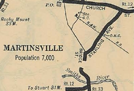
VA 12 using Starling
1927 Official
|
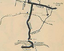
VA 12 using Broad
1929 Official
|
By 1930, VA 12 was removed from SR 691 and SR 692 east of Independence and moved to today's VA 274 closer to the river.
In June 1931 (AASHO), US 221 was attached to VA 12 from Independence to Hillsville.
In July 1931 (AASHO), US 58 was attached to VA 12 from Hillsville to Martinsville.
By 1932, VA 12 was removed from Nursery Rd/Calvary Way east of Reed Island Creek; Joppa Rd ad SR 646 Cardinal Cir west of Laurel Fork; SR 620 Tory Creek Rd/SR 780 Turnip Patch Rd at the Carroll/Floyd line area.
In 1932 (bridge date), VA 12 bypassed Woodlawn in Carroll County.
In July 1933, the entirety of the Hillsville to Martinsville dropped the VA 12 designation in favor of US 58.
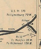
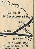
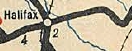
Martinsville to Halifax: VA 12 headed out Church St east to Brookdale St then southeast on that to Spruce St which becomes SR 650. VA 12 followed this to SR 620 Old Liberty Dr, then east on SR 620 through Chatmoss to Burnt Chimneys and Axton before entering Pittsylvania County.
VA 12 used US 58 east of SR 620, then followed SR 855-854-622 to West Fork; US 58; SR 708; then US 58 through Brosville. VA 12 followed VA 51 in its entirety into Danville, then along US 58 Business to Union St, then across the Dan River to VA 413 Memorial Dr which VA 12 followed to N. Union St which led to Main St. VA 12 crossed the Dan River again onto N. Main St and followed Bradley St east to Justin Ln. which now ends at the RR. On the other side it picks up as "Old Hwy 360" whose connection back to VA 360 is broken by US 29 Bypass.
Once past the bypass VA 12 rejoins VA 360 which it follows through Keeling and Vernon Hill before reaching Halifax.
In late 1931 or so, VA 12 was rerouted to modern US 58 Business and US 58 from Martinsville to VA 51. This left behind Henry CR 1 and Pittsylvania CRs 264A, 283A, 267A and 268A.
VA 12 (1919-31)
1929 Official
|
VA 12 (1932-33)
1932 Official
|
Also in late 1931, in Danville VA 12 was removed from Bradley Rd and instead placed on VA 360 to Justin Ln.
VA 12 using Bradley Rd
1930 Official
|
VA 12 removed from Bradley Rd
1932 Official
|
In 1932, US 58 was assigned to all of the Martinsville to Danville section.
In July 1933, VA 12 was dropped from the US 58 segment, while Danville to Halifax was renumbered as US 360.
Halifax to South Hill:
Initially, VA 12 followed VA 360 to Ferry Trail; Archer Trail; Marion's Trail; Bagwell Dr-Wagstaff Rd-Wagstaff Ln (the trails no longer connect to one another), then pick VA 360 back up. VA 12 follwed VA 360 to US 360, then US 360 to VA 92 which VA 12 followed to Clover. VA 12 then followed SR 716 and SR 715 east out of Clover to use Mosley's Ferry across the Roanoke River into Charlotte County.
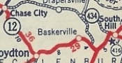
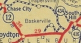
It appears VA 12 resumed on SR 705 in Charlotte County over to VA 92, then east on VA 92 to Kings Crossroads, then south on SR 631 which after a short jog on US 15 continues east back to VA 92. VA 12 followed VA 92 briefly but used the intertwined SR 600 into Chase City as 5th St. VA 12 followed VA 47-49 to VA 92 then followed VA 92 to Boydton.
In Boydton, VA 12 picked up US 58 Business east to about the mainline US 58. VA 12 initially followed a road now abandoned save a small piece of SR 608 Ridge Rd that follwed the RR tracks closely (north side) until about the current US 58-VA 4 jct. VA 12 followed "Old Plank Rd" from here which is now SR 674 to Baskerville; SR 669 to SR 668 to SR 663 to SR 645 to SR 644 to SR 661 Lombardy Grove; SR 661 to South Hill.
In late 1926, US 501 was assigned to VA 12 from Halifax to the Red Oak area and US 15 was assigned from Boydton to South Hill.
In early 1927, VA 12 was moved off SR 661 Old Plank Road onto today's US 1 into South Hill, leaving behind CR 212.
|
|
VA 12 crossing of Roanoke River |
In March 1927 (AASHO), US 15 from Boydton to South Hill was redesignated as US 401.
In 1930, VA 12 was put on today's VA 92 from Clover to Chase City (using 2nd St, as is the case still). This left behind Charlotte CR 114 and 110; Mecklenburg CR 280.
Also, about 1930, VA 12 was placed on brand new alignment (today's US 58) from Boydton to US 1 Normandy Grove. This left behind several CRs: 223A, 262, 205A, 8, 130, 5, 105, and 12.
|
VA 12 using "Plank Rd"
1932 Tydol
|
VA 12 on modern US 58's alignment
1933 Texaco
|
In 1931, VA 12 (with US 501) was straightened out east of Halifax onto the current VA 360 alignment, leaving behind all those "trails" as CR 15 and 120.
VA 12 using "trails"
1929 Official
|
VA 12 on modern VA 360's alignment
1932 Official
|
In May 1931 (AASHO), the US 401 designation along VA 12 was renumbered as US 58.
In July 1933, VA 12 was renumbered as US 360 (VDOH actually requested US 33) from Halifax to the Red Oak area; VA 46 to Boydton; remained US 58 to South Hill.
The 1933 draft route log had VA 12 from Danville to the Red Oak area becoming part of VA 40.
South Hill to Suffolk:
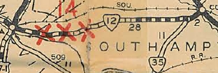
VA 12 followed US 58 east past I-85 then followed High St to La Crosse. VA 12 cut north on SR 618 Main St, then east on PIne St out of La Crosse. VA 12 followed US 58 a little, then Watkins Rd/Lambert Ln to the Broadnax area.
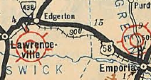
VA 12 continued along US 58 to SR 623 except it used Jones Circle Rd. VA 12 followed SR 623 to Diamond Grove, then SR 644 back to US 58 which VA 12 followed into Lawrenceville via US 58 Business (best as I can tell).
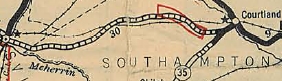
East of Lawrenceville, VA 12 followed SR 606 to Edgerton, Totaro and into Greensville County. VA 12 then followed SR 607 through Radium and Kingsbury before meeting back up with US 58 near I-95. VA 12 used Westend Dr right at I-95's crossing, then current US 58 Business through Emporia until Halifax St (just past US 301). VA 12 cut south on Halifax St then east on Valley St/Southampton St back to 58 Business.
VA 12 followed US 58 into Southampton County but veered south on SR 615 which loops back to US 58 after a while. After a brief turn on today's US 58, VA 12 followed SR 654 through Dreweryville, Worrell, and Pope before coming back to today's US 58. VA 12 did NOT use the piece of 654 that runs from Pope directly to Courtland unless it was in 1918-19. Instead it followed US 58 and 58 Business through Courtland.
VA 12 followed US 58 and 58 Business into Franklin, then used Clay St, 4th Ave, Main St and 2nd Ave (not 58 Bus' route now) to head east. VA 12 followed US 58 Business to Carrsville and Holland, then US 58 a few miles, then US 58 Business and then VA 337 to downtown Suffolk.
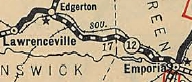
In 1926, VA 12 was moved to today's SR 750 and US 58 from east of Lawrenceville to Edgerton, leaving behind CR 12.
In late 1926, US 117 was assigned to VA 12 from Franklin to Suffolk.
About 1929, VA 12 was given US 58's current routing between ECL Emporia and Pope, leaving behind CRs 137 and 136.
VA 12 on modern SR 615/654's alignment
1927 Official
|
VA 12 on modern US 58's alignment
1929 Official
|
In May 1931 (AASHO), US 58 was assigned to VA 12 from South Hill to Franklin and replaced US 117 from Franklin to Suffolk.
In late 1931, VA 12 was put on today's US 58 alignment from Edgerton to Emporia, leaving behind more CR 12 and Greensville CR 123.
VA 12 on original alignment east of Edgerton
1927 Official
|
VA 12 on modern US 58's alignment
1932 Official
|
In July 1933, this entire segment of VA 12 became just US 58.
Suffolk to Virginia Beach:
This segment's early alignment is obtained from the 1919 Topo Maps of the area. VA 12 was 100% duplexed with VA 10 from Suffolk to Virginia Beach as follows:
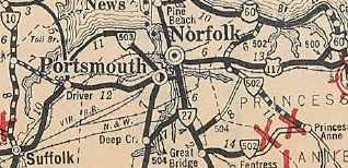
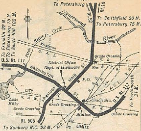
VA 10-VA 12 followed VA 337 from Suffolk to Driver, then to Portsmouth along what was then called Suffolk Rd (current VA 337 ALT) to 6th St to High St. The route followed High St towards the ferry to Norfolk. Then the route did a zig-zag using 1st St, London St, then Water St south to Queen St east to the ferry. Once in Norfolk, the route picked up Bank St over to Princess Anne Rd over to Battery Rd (this is just east of Park Ave and may not exist now) and then to Broad Creek Rd (this is Virginia Beach Blvd).
The route followed Virginia Beach Blvd to Witchduck Rd. Then two possibilities existed - current Va Beach Blvd east to Happy Rd to Bonney to Rosemont OR it used Euclid, Alicia, Baxter and Bonney Rds (broken up by I-264 today) to get to Rosemont.
The route ran northeast of today's US 58 on destroyed routing to use either Alcott or Edinburgh Dr to get over to Lynnhaven Rd. The route used Lynnhaven Rd southeast to Lynnhaven, then ran through today's I-264/Lynnhaven Pkwy interchange to connect with today's Potters Rd at Wesley Dr.
The route followed Potters Rd east to First Colonial Rd, then north on that across US 58 Bus to I-264. At that time, a road went due east and connected with today's "Old Virginia Beach Rd." VA 10-VA 12 followed this until it became 23rd Ave on over tothe waterfront. Today this is broken up by I-264 right by the Great Neck Creek bridge near Birdneck Rd and now requires passing through the parking lot of the Contemporary Art Center of Virginia.
In 1923, VA 12 was removed from the entirety of the VA 10 duplex east of Suffolk. About that time VA 10 was placed on Virginia Beach Blvd all the way out to the oceanfront, so VA 10-VA 12 was downgraded to Princess Anne CRs 114, 202, 205, 115, 213, 2, 109 and 210
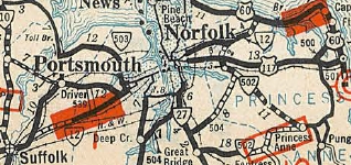
In late 1930, VA 12 was extended along VA 10 again (still current VA 337) over to Magnolia, then replaced VA 527 and may have been some new routing to Bowers Hill (used current US 58) and along new Airline Blvd to Alexander Corner where it met back up with VA 10. VA 12 followed VA 10 until the routes reached Battery Ave.
VA 12 continued along Princess Anne Rd (today's VA 166) until it reached Kempsville Rd. VA 12 cut south on this (current VA 165) a brief period then turned northeast through the Norfolk Waterworks on today's VA 165Y. VA 12 continued along today's US 13 (this connection is now cutoff by the I-64/US 13 interchange). Until it reached Shell Rd (at Diamond Springs jct). VA 12 followed Shell Rd to Independence Blvd except the Lake Smith crossing which appears to be US 13's location. VA 12 then followed Pleasure House Rd until it ended at US 60/VA 500 Shore Dr. The part from VA 10 to today's 165Y was new routing; 165Y to US 60 was a replacement for some of VA 502.
no VA 12 in sight
1930 Official
|
VA 12 extended through Norfolk
1931 Official
|
In Oct 1931 (CTB), VA 12 was placed on Airline Blvd from Alexanders Corner to High St. when it was added to the state highway system.
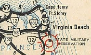
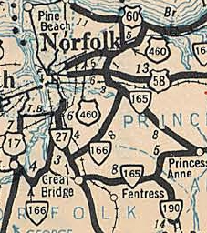
In 1932, VA 12 was extended east along US 60 (replacing the hidden VA 500 duplex) around Cape Henry and Fort Story (used the old VA 305 stubs, not the modern US 60) and down Atlantic Avenue. US 60 ended at US 117/VA 10 17th St, but VA 12 continued down Atlantic Avenue across Rudee Inlet to end at the Rifle Range which is now part of Camp Pendleton. South of 31st St was a renumbering of VA 501. VA 12 did not use any of General Booth Blvd as the bridge was straight and along the shore. It is unclear exactly where VA 12 ended but the initial road to the Rifle Range was assigned as 1.5 miles from VA 10. So the endpoint was perhaps Atlantic Ave S at Croatan Rd. or it may have ended at a gate or continued to Rifle Range Rd (not possible now).
VA 12 extended along the Oceanfront
1932 Official
|
VA 12 replaced by US 460 in Norfolk
1933 Official
|
Also in 1932, VA 12 was sent through Suffolk using Main St north to today's US 58 Business which was mostly new routing.
everything through downtown
1931 Official
|
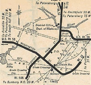
the first "bypass" in Suffolk
1932 Official
|
In July 1933, VA 12 was replaced by US 58 from Suffolk to Norfolk; US 460 from Norfolk out to Chesapeake Beach (draft 1933 route log had this becoming part of VA 10; US 60 remained around to the Oceanfront and was extended to replace VA 12 to the Rifle Range.
Today it is US 58 Bus from Suffolk to Magnolia; US 58 to Portsmouth; High St towards the Elizabeth River; 1st St, London St, then Water St south to Queen St east to the ferry to Norfolk; in Norfolk, it used Bank St over to Princess Anne Rd (no longer possible today) and followed VA 166 east; south on VA 165; northeast through the Norfolk Waterworks on today's VA 165Y to US 13 Northampton Blvd (this connection is now cutoff by the I-64/US 13 interchange); US 13; Shell Rd (at Diamond Springs jct) to Independence Blvd except the Lake Smith crossing which appears to be US 13's location; Pleasure House Rd; US 60 east to Seashore State Park; old VA 305 through Fort Story back to US 60 along the waterfront; Atlantic Ave to the end at Rudee Inlet; S. Atlantic Ave below Rudee Inlet.
The 1926 Official Map has a route log that showed VA 12 to be 413 miles at that time.
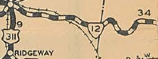
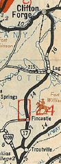
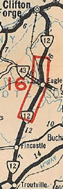
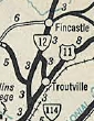
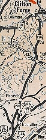
VA 12 #2: VDOT quickly recycled the number 12 in July 1933. It ran from US 11 Troutville to US 60 Clifton Forge, replacing what had been a part of the original VA 17. It is unclear if VA 12 used the lengthy Botetourt SR 655 very briefly or if VA 17 was moved onto the modern alignment first.
In Clifton Forge, VA 12 met US 60 at the jct of E. Ridgeway and River Rd, crossed the Jackson River via covered bridge immediately and used Verge St over to current US 220 Business.
In Iron Gate, VA 12 used Commerce and 5th St to cut over to Market Ave.
In Eagle Rock, VA 12 used today's VA 43 from US 220 down to the SR 870 area where it crossed the James River over to Riverside Dr.
In 1934, VA 12 was placed on upgraded secondary route to connect between Trinity and Daleville, then paired with VA 114 down to US 11 at Cloverdale. The old route from Trinity to Troutville became VA 294 (now SR 670).
In Sept 1934 (AASHO), VA 12 became part of US 220. Note that the Oct 1934 state official still showed VA 12.
VA 17 Troutville to Clifton Forge
1932 Official
|
VA 12 Troutville to Clifton Forge
1933 Official
|
VA 12 rerouted to Cloverdale
Oct 1934 Official
|
VA 12 renumbered to US 220
1936 Official
|
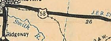
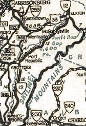
VA 12 #3: VDOT again ran this number back out in the field in a hurry by 1935 to replace VA 340. It began at US 11 near Greenville and went to Waynesboro, Mt. Meridian, Grottoes, Port Republic, Montevideo, Elkto, Stanley, Luray, Front Roya, White Post and Boyce before ending at VA 7 (now VA 7 Business) Berryville.
It is unclear if VA 12 used SR 718 Hinton Rd north out of Luray. VA 815 in 1932 was still using it and VA 12 is shown bypassing it on the 1935 Page County map.
|

VA 12 zig-zag in Berryville
1946 Clarke County
|
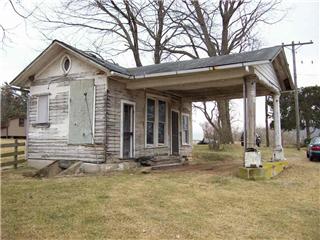
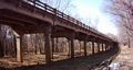
An abandoned gas station on old VA 12 near VA 256 (courtesy Geoff Laidman)
Not long after VA 12 replaced VA 340, it was given today's modern US 340 routing from Front Royal south to Luray, avoiding Browntown Rd entirely (the 1936 Warren County Map shows both alignments). The old route became SR 625 but is now SR 605 Poor House Rd and SR 649 Browntown Rd. Between 1937-40, VA 12 was rebuilt in southern Warren County primarily to eliminate several RR crossings, leaving behind

VA 12 original Clarke County route
1936 Page County
VA 12 modern Clarke County route
1939 Clarke County
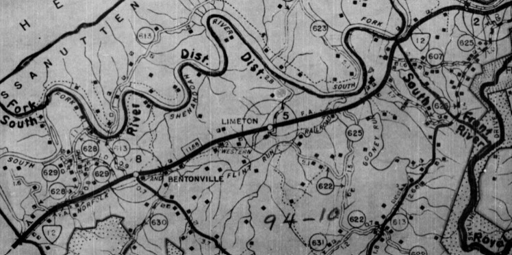
Between 1937-40, VA 12 was rebuilt in northern Page County primarily to eliminate several RR crossings, leaving behind abandoned road between SR 684 Good Mill Rd and SR 611 Van Summit Rd north to Rileyville; SR 662 back to US 340 to cross Jeremy's run; abandoned routing/SR 700 Runyon Rd/abandoned route north of Rileyville; SR 686 and SR 663 (now SR 662) in Compton; a bit of SR 664 Carvel Rd across the RR

VA 12 original Page County route
1936 Page County
|
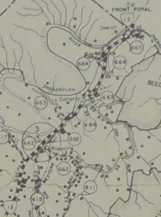
VA 12 modern Page County route
1936 Page County
|
In Sept 1942 (CTB), VA 12 between Front Royal and White Post was rerouted using modern US 340 north to Double Tollgate and US 340 east over to SR 628 to White Post (replacing some of VA 277). In Front Royal, the route changed from Royal/Main/Water/Manassas to using Royal/14th/Shenandoah (US 340's current path).
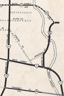
VA 12 original Front Royal route
1936 Warren County
|
VA 12 modern Page County route
1945 Warren County
|
The entire old route to White Post via Happy Creek became SR 658. Today this is SR 624 Happy Valley Rd/Morgan Ford Rd/Milldale Rd; SR 636 Ashby Station Rd; SR 658 Rockland Rd/Sugar Hill Rd/White Post Rd.
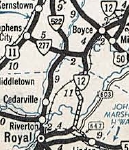
VA 12 parallels US 522
1941-42 Official
|
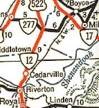
VA 12 joins US 522
1947 Official
|
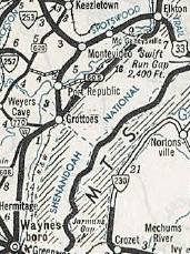
About January 1944, VA 12 began using the current US 340 alignment from Waynesboro to Elkton. In Waynesboro VA 12 had been using Wayne St north to Ohio St west to Florence Ave north to either Bridge Ave or Ash St east to Sherwood Ave which turns into Rockfish Rd. The entirety of VA 12 north of Wayesboro to Montevideo (several roads) was downgraded to SR 865. Beyond VA 256 the SRs have since been renumbered - SR 902 Circle Ln to cross the South River; SR 825 Dogwood Ave to Port Republic; abandoned routing/SR 955/bridge a South R gone/SR 1601; VA 253 to SR 672 Pineville Rd to US 33 (now SR 996) near Montevideo; US 33/33 Business to Elkton; Spotswood Ave in Elkton back to current US 340.
VA 12 initial Waynesboro to Elkton
1941-42 Official
|
VA 12 on old and new alignments
1943 Rockbridge County
|
VA 12 modern routing
1944 Official
|
In March 1953 (CTB), VA 12 was removed from SR 616 Church St in Berryville and also SR 617 Old Chapel Rd/bit of VA 255 and put on current US 340.
VA 12 #3 was replaced in its entirety by a very extended US 340 about 1954. Today it is still US 340 except: US 340 Business through Stanley and Luray; F1112 north of Rileyville; SR 665 Overall Rd in Overall; SR 658 north of White Post; SRs 667/668 Old Waterloo Rd below Boyce;
|