< US 441 | Home | US 501 >
US 460 Business | US 460 ALT | US 460-Y
US 60 | US 360
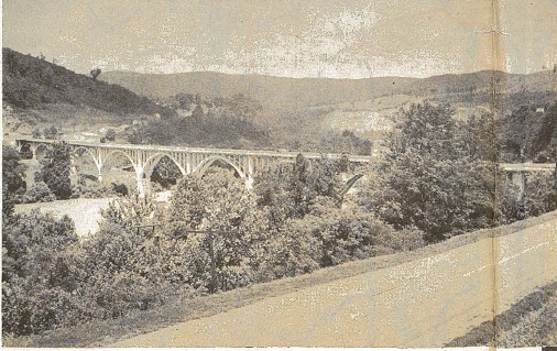
Photo: US 460's original ornate bridge over the New River in Ripplemead (photo from 1947 Official)
| US 460 < US 441 | Home | US 501 > US 460 Business | US 460 ALT | US 460-Y US 60 | US 360 |
Photo: US 460's original ornate bridge over the New River in Ripplemead (photo from 1947 Official) |
| |||||||||||||||||||||||||||||||||||||||||||||||
| ROUTE LOG US 60, US 60 ALT Begin: 0 - 0 US 60 ALT WB, VA 168: 0.71 - 0.71 I-64 (exit 276), I-564: 2.08 - 2.79 VA 165: 0.24 - 3.03 VA 247: 3.42 - 6.45 US 58: 0.66 - 7.11 US 460 ALT, VA 337 EB: 0.31 - 7.42 VA 168 NB, VA 337 WB: 0.41 - 7.83 VA 166 NB: 0.40 - 8.23 I-264 (exit 11): 0.30 - 8.53 VA 168 SB: 0.73 - 9.26 Chesapeake-Norfolk Line: 0.65 - 9.91 VA 246: 0.39 - 10.30 VA 337: 0.56 - 10.86 US 13 NB, VA 166 SB: 2.80 - 13.66 VA 196: 2.20 - 15.86 US 17: 1.01 - 16.87 I-64 (exit 297): 1.37 - 18.24 VA 191 BEGIN: 2.45 - 20.69 US 58 EB, US 460 ALT, VA 191 NB: 0.18 - 20.87 I-664 (exit 13): 0.64 - 21.51 Suffolk-Chesapeake Line: 2.41 - 23.92 US 13 Bus, US 58 Bus, US 460 Bus: 3.46 - 27.38 VA 10, VA 32 NB, VA 32 Bus: 4.17 - 31.55 US 13 SB, US 58 WB, US 460 Bus, VA 32 SB: 0.93 - 32.48 Isle of Wight-Suffolk Line: 5.09 - 37.57 US 258: 3.78 - 41.35 Southampton-Isle of Wight Line: 6.17 - 47.52 Surry-Southampton Line: 8.60 - 56.12 Sussex-Surry Line: 0.06 - 58.42 VA 31: 2.30 - 58.48 VA 40: 7.53 - 66.01 Prince George-Sussex Line: 6.90 - 72.91 VA 156: 6.20 - 79.11 I-295 (exit 3): 3.81 - 82.92 Petersburg-Prince George Line: 0.40 - 83.32 US 460 Bus, VA 106: 0.34 - 83.66 I-95 SB (exit 47): 1.60 - 85.26 US 301, US 460 Bus: 2.79 - 88.05 I-85 BEGIN (Exit 68), I-95 NB (exit 51): 0.50 - 88.55 Dinwiddie-Petersburg Line: 3.58 - 91.13 US 1, US 460 Bus: 1.18 - 92.31 I-85 SB (exit 61), US 460 Bus: 1.48 - 93.79 VA 226: 1.21 - 95.00 Nottoway-Dinwiddie Line: 22.92 - 117.92 VA 153: 0.71 - 118.63 US 460 Bus: 3.00 - 121.63 US 460 Bus: 7.38 - 129.01 VA 49 SB: 3.55 - 132.56 VA 49 NB: 1.80 - 134.36 VA 323: 1.65 - 136.01 VA 323: 0.20 - 136.21 US 360 EB: 0.39 - 136.60 US 360 Bus, US 460 Bus: 0.43 - 137.03 US 360 WB, US 360 Bus, US 460 Bus: 1.25 - 138.28 Prince Edward-Nottoway Line: 3.05 - 141.33 VA 307: 4.44 - 145.77 US 460 Bus: 4.28 - 150.05 US 15 SB, US 15 Bus: 2.75 - 152.80 US 15 NB, US 460 Bus: 4.56 - 157.36 US 460 Bus: 11.41 - 168.77 Appomattox-Prince Edward Line: 1.07 - 169.84 US 460 Bus: 0.99 - 170.83 US 460 Bus: 8.68 - 179.51 VA 24 EB, VA 131: 1.87 - 181.28 US 460 Bus, VA 26: 0.72 - 182.00 Campbell-Appomattox Line: 7.79 - 189.79 VA 24 WB: 0.11 - 189.90 Lynchburg-Campbell Line: 7.29 - 197.19 US 29 NB: 0.11 - 197.30 US 460 Bus, US 501 SB, US 501 Bus: 2.00 - 199.30 US 501 NB: 2.36 - 201.66 Campmbell-Lynchburg Line: 1.57 - 203.23 US 29 SB, US 29 Bus: 0.14 - 203.37 US 460 Bus: 5.16 - 208.53 Bedford-Campbell Line: 1.37 - 209.90 Bedford City-Bedford Line: 12.28 - 222.18 US 221 NB, US 460 Bus, VA 122 NB: 0.28 - 222.46 Bedford-Bedford City Line: 0.94 - 223.40 VA 122 SB, VA 122 Bus: 0.50 - 223.90 Bedford City-Bedford Line: 0.06 - 223.96 Bedford-Bedford City Line: 0.90 - 224.86 Bedford City-Bedford Line: 0.24 - 225.10 US 221 Bus, US 460 Bus: 0.18 - 225.28 Bedford-Bedford City Line: 0.67 - 225.95 Botetourt-Bedford Line: 14.62 - 240.57 BLUE RIDGE PKWY-VA 48: 2.94 - 243.51 Roanoke-Botetourt Line: 2.55 - 246.06 US 220 ALT NB: 0.34 - 246.40 Roanoke City-Roanoke Line: 1.63 - 248.03 VA 115: 2.69 - 250.72 US 11, BEGIN US 11 ALT, US 221 SB, VA 116 SB: 0.49 - 251.21 I-581 (exit 6), US 220, US 220 ALT END: 0.24 - 251.45 VA 116 NB: 2.31 - 253.76 VA 117: 1.75 - 255.51 Salem-Roanoke City Line: 0.65 - 256.16 US 11 ALT SB, US 460 ALT, VA 419: 0.44 - 256.60 VA 311: 1.46 - 258.06 US 11 SB: 0.11 - 258.17 US 11 ALT, US 460 ALT: 0.95 - 259.12 VA 112: 1.31 - 260.43 Roanoke-Salem Line: 1.12 - 261.55 Montgomery-Roanoke Line: 4.56 - 266.21 I-81 NB (exit 118), US 11 SB, US 460 Bus: 14.11 - 280.32 I-81 SB (exit 118C): 1.15 - 281.47 US 11, US 460 Bus: 0.25 - 281.72 US 460 Bus: 2.53 - 284.25 VA 114: 0.95 - 285.20 US 460 Bus: 0.72 - 285.92 VA 314: 1.50 - 287.42 VA 412: 1.47 - 288.89 US 460 Bus: 3.30 - 292.19 Giles-Montgomery Line: 3.86 - 296.05 VA 42: 1.16 - 297.21 US 460 Bus: 14.70 - 311.91 US 460 Bus: 1.45 - 313.36 VA 100: 0.60 - 313.96 VA 61: 3.00 - 316.96 US 219: 3.68 - 320.54 WV STATE LINE: 3.29 - 323.83 WV STATE LINE: 0 - 323.83 US 19 NB: 5.16 - 328.99 US 19 Bus, US 460 Bus: 10.71 - 339.70 VA 16: 2.75 - 342.45 VA 16 ALT: 1.43 - 343.88 US 19 Bus, US 460 Bus: 1.72 - 345.60 US 19 SB: 10.86 - 356.46 US 460 Bus: 1.25 - 357.71 US 460 Bus: 1.62 - 359.33 VA 67: 1.25 - 360.58 US 460 Bus, VA 67 NB: 1.32 - 361.90 VA 67 SB: 1.38 - 363.28 Buchanan-Tazewell Line: 6.04 - 369.32 VA 83 WB: 17.35 - 386.67 VA 83 EB: 3.95 - 390.62 KY STATE LINE: 12.83 - 403.45 |
Creation: Appeared in May 1933 (AASHO), the same year it first appeared
nationally, running from Roanoke to Chesapeake Beach via Bedford,
Lynchburg, Appomattox, Farmville, Burkeville, Petersburg, Suffolk,
Portsmouth and Norfolk. In this routing, US 460 replaced:
VA 10 from Roanoke to Lynchburg US 60 and VA 10 from Lynchburg to Burkeville VA 10 from Burkeville to Petersburg VA 52 from Petersburg to Suffolk US 117 and VA 10 from Suffolk to Norfolk VA 12 from Norfolk to Chesapeake Beach Note that Virginia actually requested this corridor be US 86, after first contemplating that Roanoke to Burkeville would become part of an extended US 221. On 1/1/47 (per Virginia Hwy Bulletin), US 460 was extended west to Kentucky, replacing:
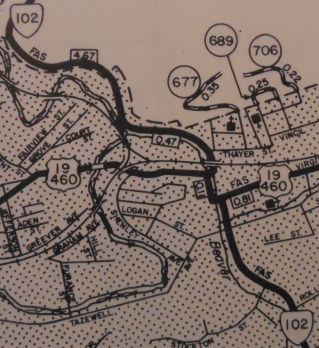
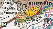
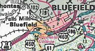
Between 1962-75, US 460 was rerouted in Bluefield to a less direct route across Bluefield. It left Graham Ave at Walnut, then south to what is now Virginia Ave then east back out of town. Originally it had used Graham Ave all the way through. In 1975, US 19-460 was placed on a freeway bypass north of Tazewell, leaving behind US 19-460 Business. This was approved by AASHO in May 1970. In June 1979 (AASHTO), US 460 was removed from US 19 through Bluefield. At that time, a new expressway was constructed from the eastern SR 720 jct east to the West Virginia line. SR 720 west to US 19-460 was signed as TEMP US 460. In 1987, US 460 TEMP was removed from SR 720 as the rest of the expressway was opened.
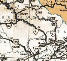
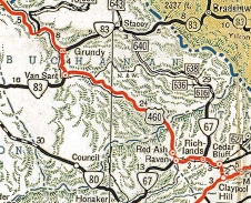
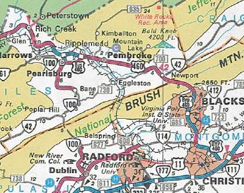
In 2009, the split routing through Grundy was removed as the EB roadway was widened to 4 lanes. The old WB routing through what used to be downtown Grundy remains Main St and a bit of VA 83. In late 2013, US 460 was placed on a new bypass of the business district along Riverside Dr in the SR 615 Levisa Rd area between Van Sant and Grundy. The old route became US 460 Business. In the future it is planned for US 460 to be put on new alignment west of the Grundy area to reach Kentucky in the vicinity of Breaks Interstate Park. As of 2022, Kentucky is mostly finished with their portion, while Virginia's portion is only complete for a short distance near Breaks Interstate Park. Estimated completion is 2027. West Virginia to Christiansburg US 460 used the SR 648 Ball Ave loop to enter Virginia, then followed SR 1306 out of Glen Lyn, which no longer connects to SR 806 leading into Rich Creek. US 460 followed Main St through town, then used US 460 towards Pearisburg. After crossing the New River, US 460 followed VA 100 south to US 460 Business which it followed through Pearisburg. On the east side of town US 460 likely used SR 807. US 460 continued on SR 636 to Ripplemead and crossed the New River just north of the current crossing. US 460 picked back up mainline 460, then used SR 1404 through Pembroke. US 460 used pieces of modern 460 but used SR 771 in Hoges Chapel; SRs 777 and 778 at Sinking Creek and SR 783 in Maybrook. US 460 used SR 796, then a bit of VA 42, then SR 797 through Newport. Crossing Walker Mountain, US 460 used several abandoned alignments, plus SR 777. US 460 then used US 460 Business through Blacksburg, Merrimac and into Christiansburg. There, it picked up US 11 north leaving Christiansburg. It
followed US 11 to Salem except it initially used SR 753 through
Shawville; SR 745 and SR 603 (no longer continuous) through Elliston;
SRs 813/821 at the Roanoke/Mongomery Line; SR 796 at Dixie Caverns.
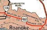
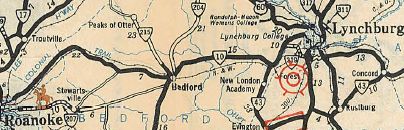
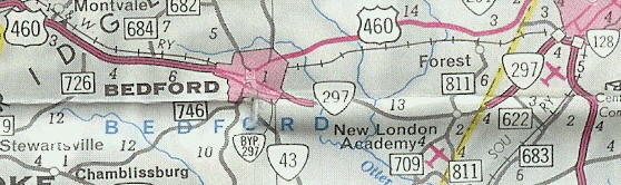
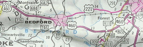
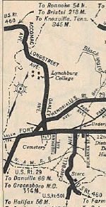
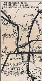
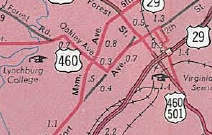
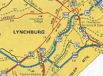
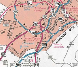
Roanoke to Lynchburg: US 460 in 1933 followed its current route east out of Roanoke (I have yet to see any evidence at all that US 460 followed US 11 into downtown Roanoke), then at Bonsack it veered onto Bonsack Rd, then back to 221-460. At Webster, US 460 used SR 738 on its way to Blue Ridge. US 460 picked back up US 221-460 through Villamont and Montvale. After more US 221-460, US 460 used SR 831 through Thaxton. US 460 then used US 221-460 and US 221 Bus to Bedford. US 460 used US 221 Business and US 221 out of Bedford over to Forest, except it used SR 646 in the Norwood area. US 460 then headed briefly north on US 501 to Old Forest Rd (old VA 291) which US 460 used to approach Lynchburg. Adjustments: In 1940, US 460 was placed on its current routing at Webster, leaving behind SR 738. In 1956, US 460 was placed on its current Thaxton Bypass leaving behind SR 831. US 460 (or US 221) was removed from SR 646 in Norwood sometime after 1958. In 1965, US 460 was removed from Bonsack Rd onto its current alignment. In November 1970, AASHO denied Virginia's request to move US 460 onto VA 297 between Bedford and Lynchburg, with the old routing becoming US 460 ALT. In December 1970 (CTB), US 460 was rerouted at Bedford onto its current Bedford Bypass and its route over to the Lynchburg Bypass. This was a replacement of VA 297. The old route became an extended US 221.
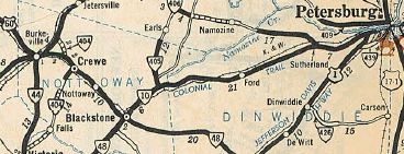
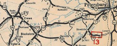
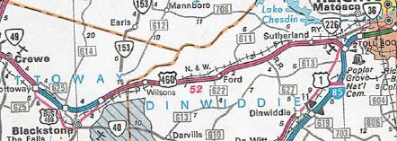
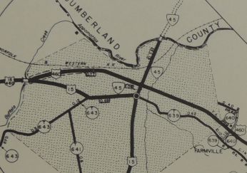
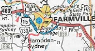
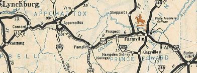
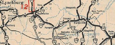
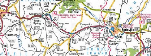
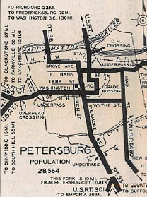
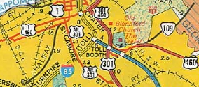
Lynchburg to Petersburg: US 460 followed its current route (save the recently altered route at the US 29 interchange) over to Appomattox, except it used SR 800 through Concord and SR 689 through Spout Spring. US 460 used 460 Business through Appomattox (possibly used SR 1004 at first), then US 460 over to Pamplin City, whre it used today's US 460 Business as well. US 460 followed its current routing east, then used SR 695 approaching Farmville instead of modern US 460. US 460 followed High St to VA 45 then north to 3rd St east out of Farmville, then current US 460 east then dipped south on today's SR 735 through Rice to modern US 460. US 460 followed today's 460 to Burkeville except it used the SR 736 loop. At Burkeville, US 460 used SR 716 Namozine St (partly cutoff from US 360-460 now), then US 360 Business 2nd St. US 460 used current 460 through Crewe, then at Nottoway CH, it followed US 460 Business through Blackstone. US 460 picked back up current 460 into Dinwiddie County. At Walkers, US 460 followed SR 751 through Poole Siding and Church Road, then back to US 460 before Sutherland. US 460 veered off using VA 226 over to US 1. Adjustments: In July 1940 (CTB), US 460 was rerouted in Farmville to the current US 460 Business routing on 3rd St all the way through. High St remained part of US 15. In 1950, US 15-460 was removed from the lengthy SR 695 west of Farmville. US 460 was removed from SR 1004 in Appomattox by 1958. By 1958, US 460 was given its current Concord routing, leaving behind SR 800. In March 1965 (CTB), US 460 was rerouted east of Sutherland to the new I-85 and US 1, which it followed north towards Petersburg. This left behind VA 226. In June 1969 (AASHO), US 460 was given its expressway bypass of Pamplin City, leaving behind US 460 Business. In Nov 1969 (CTB), US 460 was placed on its Burkeville bypass, leaving behind some SR 714 and US 360-460 Business. In 1973, US 460 was rerouted in the Rice area to its current routing, leaving behind SRs 735 and 736. The new alignment eclipsed a piece of VA 307. In 1974, US 460 was put on new alignment in central Dinwiddie County, leaving behind SR 751. In 1976, US 460 was placed on its freeway bypass of Blackstone leaving behind US 460 Business. AASHO approved this in May 1970.
In July 1977 (AASHTO), US 460 was placed on its southern bypass of Farmville, some of which was already open as US 15 Bypass. The old route became US 460 Business.
In October 1993 (AASHTO), US 460 was placed on its freeway bypass of Appomattox, leaving behind US 460 Business.
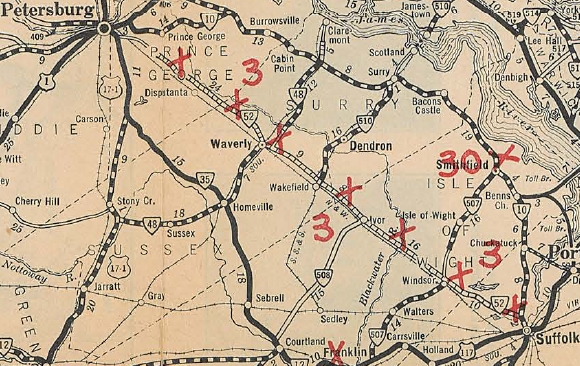
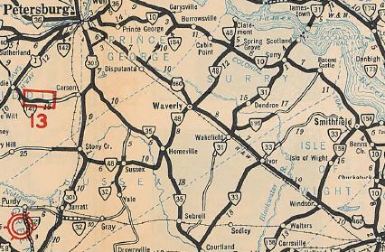
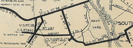
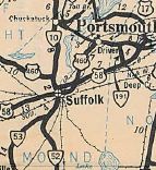
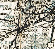
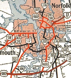
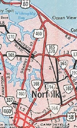
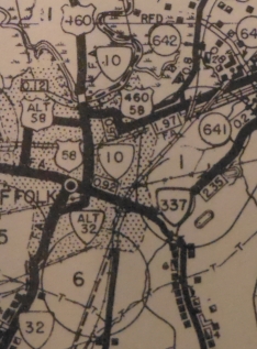
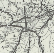
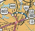
Petersburg to Hampton Roads: Initially, US 460 entered Petersburg with US 1 on Washington St. Then after a brief jog south on Sycamore (was US 301 then) used Wythe St east to Main St south out of town via today's US 460 Business. US 460 followed today's 460 through Waverly and Windsor, and picked up US 460 Business into central Suffolk. US 460 originally followed Main St to Constance, then east on removed Orchard St, then south on Katherine St and East on Pinner St to VA 337 Magnolia and then followed VA 337 through Driver to Alexanders Corner, then Airline Dr to High St to Portsmouth, crossed the ferry with US 58 to Norfolk. US 460 followed Bank St north to Princess Anne Rd east, then followed today's VA 166 northeast to today's VA 165 which it followed south, then VA 165Y (no longer connects), then US 13 to Diamond Springs Rd. US 460 then followed today's Shell Rd and Pleasure House Rd to end at US 60 in Chesapekae Beach.
Adjustments: In Oct 1934, US 460 was rerouted at Alexanders Corner to follow today's VA 337 to the Jordan Bridge (replacing VA 287) and east to VA 27 to pick up current US 460's route in South Norfolk. US 460 then left Brambleton on Park Ave north to pick up Princess Anne Road as before. US 460's old route through Portsmouth became US 58.
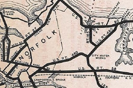
In May 1943 (AASHO), US 460 was rerouted from Suffolk to Portsmouth - it left Main St Suffolk on today's US 13-58-460 Bus east to mainline 13-58-460. US 460 then followed its current routing to Bowers Hill, Military Hwy and Bainbridge Blvd. US 460 then continued west on Brambleton Ave to end at no route at Granby St. The old route from Suffolk to South Norfolk became VA 337; Princess Anne Rd out to Military Hwy leaving Norfolk became VA 13Y; VA 165 to Diamond Springs Rd became part of US 13; Diamond Springs Rd to US 60 became the other VA 13Y (note Virginia tried to have the 2 VA 13Y segments numbered as US 13Y first).
By 1954, US 460 was rerouted in Petersburg to used Washington St directly to Crater Rd south. In Oct 1957 (CTB), US 460 in Suffolk was moved onto Constance St east of Main, leaving behind Katherine and Pinner Sts (now also E Old Pinner). In 1958, US 460 was rerouted in Norfolk to its current routing to US 60 Ocean View, replacing VA 170 on Granby St.
In Feb 1961 (CTB), US 460 was split in Petersburg - EB US 460 had to follow US 301 south to I-95 and use what had been US 460 ALT to get back to Winfield Rd which US 460 WB continued to use. In Aug 1973 (CTB), US 460 was given its freeway bypass of Suffolk, leaving behind US 460 Business. AT first it was just US 460 as the freeway wasn't open west of there back to US 58.
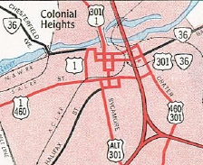
About 1976, US 1-460 was placed on one-way splits using Washington and Wythe Sts. In December 1988 (AASHTO), US 460 was placed on I-85 at Exit 61 up to I-95 then it got off I-95 at the next exit. Here it replaced unsigned US 460 ALT back to US 460 near Ft. Lee. The old route became US 460 Business.
Around 2007, US 460 was rerouted to stay on I-95 south to Wagner Rd, then put on Wagner Rd east to US 460/VA 106. This left behind an extended US 460 Business. In fall 2020, US 460 was removed from a dogleg in South Norfolk at VA 246 using a bit of Liberty St and 22nd St to reach the bridge over the railroad. Now Poindexter connects directly to a new bridge which ties into the original rotuing halfway across the bridge. A new US 460 tollway was expected to begin construction in 2014 between I-295 and US 58. The tollway would be built south of existing US 460. However, despite spending a substantial amount of money, VDOT was not able to get environmental approvals for this endeavor. In 2015 the proposed project was pared down to a new alignment from east of Zuni to the Suffolk Bypass. Improvements: The entirety of US 460 was paved upon its designation in July 1933. The first multilaning of US 460 occurred by 1941, where US 460 was multilaned from Petersburg to Suffolk except for Sussex County. US 460 was multilaned when moved to Military Hwy around 1942, plus from Magnolia to Bowers HIll. Sussex County's US 460 was widened by 1947. In 1949, US 11-460 was multilaned from roughly Elliston to near the current WCL of Salem. In 1952, US 460 was multilaned on its Campbell Ave run in Lynchburg and also from Christiansburg east a couple miles. In 1953, US 11-460 was widened from the bottom of Christiansburg Mtn to Elliston. In 1954, US 460 was multilaned west a couple miles from Bedford. In 1955, US 460 was widened from US 501 east a couple miles and also the Bedford segment was widened to about Thaxton. In 1956, US 460 was widened for a mile east out of Pearisburg; the segment east of US 501 was extended halfway to Concord; the Bedford segment was extended around Thaxton and a few more miles west. In 1957, US 460 was widened from Salem to VA 117. In 1958, US 460 was multilaned when it was added to Granby St in Norfolk. In 1959, the US 460 Bedford segment was widened west to just short of Botetourt County. In 1960 or 1961, US 460 was widened from Suffolk to Magnolia and also on its Brambleton Ave stretch. In 1963, US 460 was widened from VA 117 to VA 116 and also from 11th Ave to US 11-220 in Roanoke. In 1964, US 460 was multilaned from Deel to about Jamey. In 1965, US 460 was multilaned from VA 114 to VA 111; the Bedford segment was widened to Botetourt County; also from a little east of Concord to Appomattox. In 1966, US 460 was widened from VA 114 north to the SCL Blacksburg ; also from the Blue Ridge Pkwy to Bedford County; also the missing Concord segment was widened; also from US 360 west a couple miles. In 1967, US 460 was widened from a little east of VA 115 to the Blue Ridge Pkwy. In 1968, US 460 was multilaned from Jamey to Raven; a segment west of Bluefield was widened; also Appomattox east past Evergreen was widened. In 1969, US 460 was widened from Cedar Bluff to Claypool Hill; also from the current east end of the Tazewell Bypass to the Bluefield segment; west of Newport to the north end of the Blacksburg Bypass; US 460 was widened from Burkeville to Crewe. In 1970, US 460 was widened from Raven to Richlands; the Blacksburg Bypass; the Christiansburg Bypass; VA 115 east to previous widening; Evergreen to the east end of Pamplin City Bypass; Sutherland to US 1 In 1971, US 460 was widened from Glen Lyn partway to Rich Creek; VA 61 to the New River; The relocated segment of US 460 from Bedford to Lynchburg; US 301 duplex In 1972, US 460 was multilaned on the Richlands-Cedar Bluff Bypass; Pamplin City to Prospect; Farmville to Rice; Crewe to Nottoway In 1973, US 460 was widened from Claypool Hill to Pounding Mill; US 11 to VA 115; Rice to Burkeville; Suffolk Bypass In 1974, US 460 is shown multilaned from Glen Lyn to VA 61; Prospect partway to Farmville; Ford to Sutherland. The Rice to Burkeville segment was shown as 2-lane on 1974 official. In 1975, US 460 was widened on the Tazewell Bypass; Pearisburg to near Pembroke; Rice to Burkeville In 1976, US 460 was widened from Pounding Mill to Tazewell; Pembroke eastward a couple miles; Nottoway-Blackstone Bypass; one-way splits with US 1 in Petersburg In 1978, The gap on US 460 between Pearisburg and Newport was widened; the west half of the Farmville Bypass; east end of Blackstone Bypass to Wilson In 1979, the eastern end of the Bluefield Bypass and half the gap between Wilson and Ford were widened. In 1980, US 460 was widened in the Grundy area; gap west of Pearisburg; Wilson to Ford gap In 1981, US 460 was multilaned on the Pearisburg Bypass. In 1988, US 460 was widened across the Elizabeth River down to the VA 168 split. In 1991, US 460 was multilaned through Petersburg by being added to I-85 and I-95. In 1994, US 460 was multilaned on the Appomattox Bypass In 1997 or 1998, US 460 was widened on the eastern half of the Farmville Bypass In 1999 or 2000, US 460 was multilaned on the western half of the Bluefield Bypass. In 2002, US 460 was widened from Grundy halfway to Van Sant. In late 2013, US 460 was multilaned on the new bypass built between Van Sant and Grundy. In Jan 2015, US 460 was 4-laned between Glenvar and VA 112. Much of US 460 between Military Hwy and South Norfolk is undivided 4-lane, but VDOT Maps do not show this. The remaining 2-lane segments of US 460 in Virginia are: Kentucky to Grundy; I-81 to bottom of Christiansburg Mtn (3 lanes); through central Salem; VA 116 to 10th St in Roanoke (3 lanes); inside the corporate limits of Crewe (3 lanes); bits and pieces in the South Norfolk area Posted: Fully posted; Erroneously still fully posted with US 19 through Bluefield; the last known cutouts associated with mainline US 460 are on this piece of US 19 - 3 cutouts in Bluefield were still up in 2008 but only 1 remains as of 2021 Error VA 460 shields at I-64, Exit 297 since at least 2006. Multiplexes: US 58 Bus (1.76 mi) VA 337 (0.41 mi) VA 168 (0.40 mi) VA 166, VA 168 (1.03 mi) VA 166 (4.40 mi) US 13 (7.03 mi) US 13, VA 191 (0.18 mi) US 13, US 58 (10.68 mi) US 13, US 58, VA 32 (0.93 mi) I-95 (3.29 mi) I-85 (5.24 mi) VA 49 (1.80 mi) US 360 (1.68 mi) US 15 (4.56 mi) VA 24 (8.62 mi) US 29 (3.71 mi) US 29, US 501 (2.36 mi) US 221, VA 122 (1.44 mi) US 221 (22.50 mi) US 220 ALT, US 221 (4.81 mi) US 11 ALT, US 220 ALT, VA 116 (0.24 mi) US 11 ALT, VA 116 (2.31 mi) US 11 ALT (2.84 mi) US 11 (22.15 mi) I-81 (1.15 mi) US 19 (27.47 mi) VA 67 (1.38 mi) VA 83 (3.95 mi) Legislative names: Governor George C. Peery Highway, Tazewell County (since 3/4/90); Freya Dalton Bridges over VA 67 (since 4/14/98); C. Jefferson Stafford Highway, Bluefield Bypass (since 4/6/96); Andrew S. Rowan Bridge (3/5/40 designation predates US 460); Mary Porter Bridge over East River (3/5/40 designation predates US 460);Anderson E. Shumate Memorial Bridge over New River (3/2/42 designation predates US 460); Madison E. Marye Highway, between Blacksburg and Christiansburg US 460 Business routes (since 3/16/03); Terry L. Griffith Memorial Highway, in Town of Christiansburg (since 3/13/01); 116th Infantry Regiment Memorial Highway, from Roanoke to Bedford (since 3/2/97); Colonial Trail, from Roanoke to Bedford and from Lynchburg to Petersburg, not including bypasses (3/24/30 designation predates US 460); Charles T Moses Memorial Highway, from Appomattox to Lynchburg (since 2/23/66) Other names: Virginia Ave (Glen Lyn, Rich Creek, Narrows); Roanoke St (Montgomery County east of I-81); W. Main St (Roanoke County west of Salem); Main St/E. Main St (Salem); Melrose Ave/Orange Ave (Roanoke); Challenger Ave (Roanoke County east of Roanoke); Lynchburg-Salem Tpk (Bedford County except Bedford Bypass); Lynchburg Hwy (Campbell County and Lynchburg); Richmond Hwy (Appomattox County); Virginia Ave (Crewe); Cox Rd (SR 627 to VA 226); Airport St (VA 226 to I-85); County Dr (VA 106 to Sussex County); Pruden Blvd (Suffolk west of Bypass); Suffolk Bypass (guess); Military Hwy (Suffolk Bypass to VA 166 except in Bowers Hill); Bainbridge Blvd/Poindexter St/22nd St (Chesapeake); Wilson Rd/Campostella Rd/Brambleton Ave/St Pauls Blvd/Monticello Ave/Granby St (Norfolk) Scenic Byway: US 19 duplex except Tazewell Bypass (9/15/99) Comments: US 460 is a major artery throughout Virginia. As such, US 460 would probably make more sense to be routed with I-81 around Salem and Roanoke and using 220 ALT to get back down to present US 460. Norfolk has now fully signed US 460 along Church St between Monticello Ave and Brambleton Ave, a process that began ca. 2004. However, official VDOT documents still have US 460 as following Monticello Ave. | ||||||||||||||||||||||||||||||||||||||||||||||
Previous: US 421 |
Next: US 501
US 460 Business | US 60 | US 360
Top | Virginia Hwy Index
Home
Page last modified 30 January 2022