ROUTE LOG
US 360: 0 - 0
VA 161 NB: 0.81 - 0.81
VA 161 SB: 0.43 - 1.24
Chesterfield-Richmond LINE: 2.66 - 3.90
VA 150: 0.60 - 4.50
VA 288: 4.40 - 8.90
VA 145: 1.80 - 10.70
VA 144 SB: 4.37 - 15.07
VA 144 NB: 0.25 - 15.32
US 1, US 301: 1.68 - 17.00
I-95 (exit 61): 0.44 - 17.44
I-295 (exit 15): 3.93 - 21.37
Prince George-Chesterfield LINE: 2.97 - 24.34
Hopewell-Chesterfield LINE: 0.42 - 24.76
VA 36: 0.12 - 24.88
VA 156 Bus SB: 1.14 - 26.02
Prince George-Hopewell LINE: 1.26 - 27.28
VA 106 SB, VA 156 SB, END VA 156 Bus: 1.17 - 28.45
VA 106 NB, VA 156 NB: 0.73 - 29.18
Surry-Prince George LINE: 12.71 - 41.89
VA 40: 5.45 - 47.34
VA 31 SB: 7.90 - 55.24
VA 31 NB: 1.04 - 56.28
Isle of Wight-Surry LINE: 9.88 - 66.16
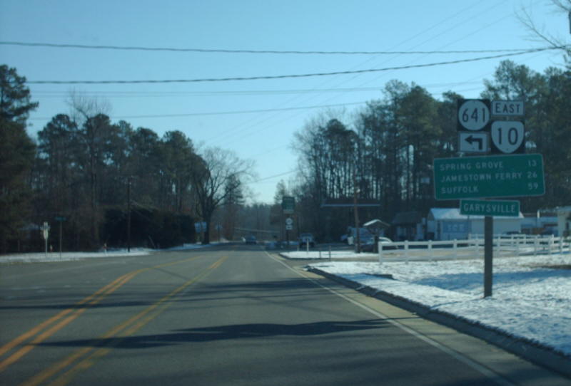
VA 10 Bus: 4.12 - 70.28
US 258 SB, US 258 Bus: 3.74 - 74.02
US 258 Bus, VA 10 Bus: 2.30 - 76.32
US 258 NB: 1.96 - 78.28
VA 32 NB: 0.18 - 78.46
Suffolk-Isle of Wight LINE: 3.97 - 82.43
VA 125: 1.31 - 83.74
US 13, US 58, US 460, VA 32 SB, Begin VA 32 Bus: 7.04 - 90.78
US 460 Bus WB: 0.54 - 91.32
US 13 Bus NB, US 58 Bus, US 460 Bus: 1.49 - 92.81
US 13 Bus SB, VA 32 Bus SB, VA 337: 0.74 - 93.55
|
|
Creation: Began in January 1918 as an original state route defined by the general assembly:
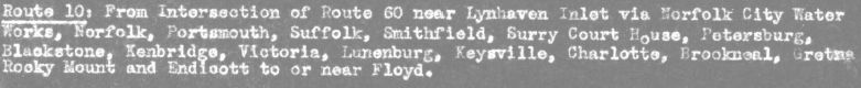
Route 10: Virginia Beach, Norfolk, Suffolk, Smithfield, Surry CH, Petersburg, Blackstone, Nottoway, Farmville, Appomattox, Lynchburg, Bedford, Roanoke, Salem, Christiansburg, Dublin, Pulaski, Wytheville, Marion, Abingdon, Bristol, Gate City, Stickleyville, Pennington Gap, Ben Hur, Jonesville, Cumberland Gap; with connection Abingdon, Greendale, Bolton, to a point on Route 11 in Russell County
Adjustments: From a geographic point of view, here is how VA 10 originally ran and adjusted:
Cumberland Gap to Woodway
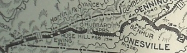
VA 10 appears to have originally begun at the Tennessee State Line within the Cumberland Gap Historical Park, where US 25E's south exit from Virginia was located. VA 10 was 100% duplexed with VA 11 from were to Woodway.
VA 10-VA 11 followed what is now a restored trail through the Cumberland Gap Historic Area. It used SR 872, then an unnumbered road that parallels the modern US 58 to the north eastward. The route used the SR 912 loop, then maybe modern US 58 but there is what looks like an old alignment on satellite photo that is not a road today.
VA 10-VA 11 used SR 732 through the old Gibson Station area, then the piece of SR 692 that is north of US 58. THe route may have followed modern US 58 over to Wheeler, then SR 729. The route then seems to have followed modern US 58 to Kesterson Mill.
VA 10-VA 11 followed SR 684 routing south of US 58, but not north of it unless it was before 1927. The route followed US 58 BUsiness through Ewing. The route likely used SR 697 and SR 672 to go to Rose Hill.
VA 10-VA 11 followed modern US 58 until SR 670, then used the SR 813 loop to Henegartown. The route used a small bit of SR 621 and all of SR 814 in the Russels Store area. Continuing east the route used SR 946 (except used the SR 815 loop), then SR SR 899 and SR 880 down to Cony Hollow.
VA 10-VA 11 followed modern US 58 from here to Jonesville except used the SR 836 and SR 745 loops. Then the route followed US 58 ALT north of Jonesville to Ben Hur except it likely used SR 715, 716, and 760, plus it looks like some alignments have been destroyed.
In Ben Hur the route likely used some SR 645 and SR 644 then modern 58 ALT to Sulphur Springs, where the route probably used Combs Rd to Pennington Gap. The route in Pennington Gap seems to have been modern 58 ALT, then US 421 south of town. The route then seems to have used a bit of SR 630 plus a dead end alignment back to US 421. The route used SR 785 into Woodway.
Adjustments:
In 1923, VA 10 was rerouted at Cumberland Gap, replacing VA 11 over to the Kentucky Line. The original VA 10 descent to Tennessee became VA 107 (most of this is now abandoned and physically removed except about 150 ft of SR 872's southwest entry to Tennessee). The VA 11 overlay to Woodway was also dropped at this time.
In 1927, US 411 was assigned to all of this stretch of VA 10.
In July 1933, VA 10 was removed from Cumberland Gap to Jonesville in favor of US 58; Jonesville to Woodway became VA 64.
VA 10 duplexed with VA 11 Cumberland Gap to Woodway
Woodway to Wytheville:
VA 10 used SR 785 back to US 421, then followed that to US 58, VA 10 used SR 915 up Wallen Ridge and US 58-421 off Wallen Ridge, then SR 702 to Stickleyville. Then VA 10 used US 58-421 over Powell Mountain, then headed south on SR 638 through Pattonsville and down to SR 600. VA 10 picked up SR 600 east to Clinchport, using SR 882, abandoned routing, SR 883 and VA 65 west.
VA 10 then followed US 23-58-421 past Speers Ferry, then used SR 870 to Gate City. VA 10 followed Bus 23-58-421 through Gate City, then picked up mainline US 23-58-421. Before Weber City, VA 10 veered off at today's SR 619. This road used to be continuous over to today's US 58-421 east of VA 224 but it is now a VDOT maintenance yard.
VA 10 likely used SR 701 and SR 614 over to Hiltons, then SR 709, 689 and 692 instead of US 58-421 southeast of Hiltons. The 1932 county atlas shows 58-421 routing, but it is not paved, so I have no date to say for sure it stopped using 614 if it ever used it. It appears VA 10 followed US 58-421 east of Hiltons to Bristol.
VA 10 used State St into central Bristol, then Front St north to Spencer St northeast to Mary St east to Goodson St north to Danville Ave east to Fairview St north to Massachussetts Av east to Texas Av north which becomes Old Abingdon Hwy. which runs back into US 11-19 near the I-81 interchange.
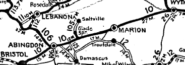
If VA 10 ever used SR 645 through Wallace to get to Abingdon it stopped doing so by 1923. VA 10 followed US 11-19 approaching Abingdon, then used Colonial Ave and crossed the railroad to modern US 11 at roughly the Bytt St location. It appears VA 10 used SR 609 through Meadowview, Emory and Glade Spring, then used SR 751 south to US 11 in eastern Washington County.
VA 10 followed US 11 to Chillhowie where it followed Main St (no longer connects back to Lee Hwy), except I-81 has broken up the actual US 11 alignment (for example, the stranded 4-lane alignment south of I-81 in this area). VA 10 followed US 11's current path to Marion (except used SR 642 through Seven Mile Ford) and appears to follow today's US 11 all the way to Wytheville.
VA 10 Bristol to Roanoke
Adjustments:
In 1923, VA 10 was removed from SR 609/751 and placed on modern US 11 (except it used SR 754 in the Blacksburg area).
In 1927, US 411 was assigned from Woodway to Bristol; US 11 from Bristol to Wytheville.
In Feb 1930 (CTB), VA 10 was rerouted to remain on Piedmont Ave north to Euclid, then northeast out of town. Mary St/Goodson St/Danville Ave/Fairview St/Massachusetts Ave became part of an extended VA 109. but Texas Ave and Old Abingdon Hwy became SR 645 (now all within the City of Bristol and unnumbered now).
In 1930 (bridge dates), VA 10 was rebuilt between Weber City and ristol to use today's US 58-421 leaving behind a few loops described above plus plenty of abandoned alignments/driveways.
In July 1933, VA 10 was removed from this segment, becoming VA 65 from Woodway to Dot; US 58 from Dot to Bristol; US 11 from Bristol to Wytheville.
VA 10 original Bristol route
|
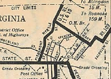
VA 10 rerouted in Bristol
|
Wytheville to Roanoke:
VA 10 entered Wytheville with US 11 on Grove Ave, then on Main St. East of Downtown, VA 10 used S. 11th St and E. Withers Rd, then S. Chapman Rd. It is difficult to determine if any of the frontage roads along I-77/81 were the actual alignment of VA 10. By the US 52-VA 121 interchange, the north frontage road is the correct location. VA 10 followed this. VA 10 used an abandoned alignment wedged between the frontage road and I-81, then the SR 697 loop around Carters Grove Wayside.
VA 10 used the E. Lee Hwy frontage road until just before the Pulaski County Line where it dipped to the south frontage road across I-81. VA 10 continued along that F-047 alignment (except the US 11-VA 100 interchange which eliminated some of the route) east to Draper, then used "Old VA 100" northeast to just past VA 99.
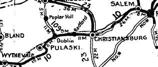
VA 10 headed west on SR 672 Lilly Rd which now ends shortly at I-81. On the other side, VA 10 used McAdam Crossing Dr and Craig Loop along today's VA 99 west. VA 10 then used Dora Hwy west to Pulaski. VA 10 turned north on today's US 11, which it essentially followed to Dublin. VA 10 probably used Peppers Ferry Rd to Main St originally, but by 1932 was using Broad St to Giles Ave south to Main St.
VA 10 used Main St east from Dublin out to US 11 near Radford. VA 10 used US 11 to the New River Bridge (except it used Warden Ct.). Once in Radford, VA 10 followed US 11 to VA 177 south, then used Auburn Ave which loops back over VA 177. VA 10 followed Auburn to Rock Rd east to US 11. VA 10 used US 11 then SR 604 Plum Creek Rd. VA 10 used pieces of Barringer Mtn Rd, Lynnwood Ln and Harmon Rd to get to Christiansburg.
|
|
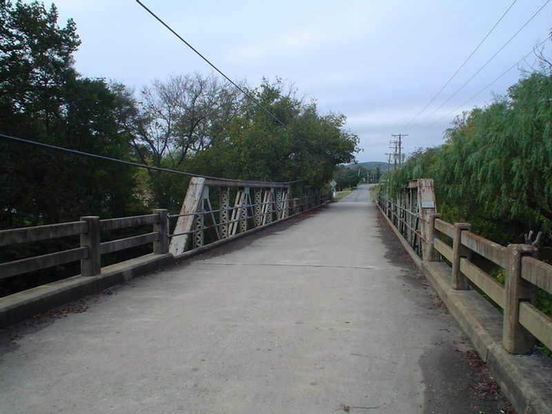
VA 10's old westbound look across S. Roanoke River |
It appears VA 10 used current US 11 through Christiansburg. At the Christianburg Wayside, VA 10 used SR 641 to descend the mountain then picked back up US 11-460.
At Shawsville, VA 10 used SR 753, Old Town Rd. After more US 11-460, VA 10 used SR 603 Old Roanoke Rd (discontinuous) through Elliston. After more US 11-460, VA 10 used SR 813 Stones Keep Ln to cross the Roanoke River. The road no longer crosses the RR and picks back up as SR 821 Joyce Ln and Peaceful Dr which runs back to US 11-460 at Wabun. At Dixie Caverns, VA 10 used SR 796 Pleasant Run Dr.
|
VA 10 followed US 11 to Salem, turning south on College St like US 11 does now. Immediately after crossiong the river, VA 10 cut east on Riverside Dr which runs back into US 11 near the VA 419 jct. VA 10 then followed US 11's routing to downtown Roanoke.
VA 10 Wytheville to Roanoke
Adjustments: In 1927, US 11 was added to this segment of VA 10.
No later than 1928, US 11 was rerouted in Roanoke to use 13th to Patterson to Campbell and also given one-way splits in Roanoke - NB used Campbell Ave while SB used Salem Ave to 3rd St back to Campbell.
Around 1929, US 11 was put on its current Pulaski approach from the south, but VA 10 remained on the 'S' routing it used.
In July 1933, VA 10 was dropped for US 11. The Pulaski 'S' became part VA 100 and VA 99
|
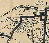
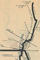
VA 10 using Patterson
1927 Official
|
Roanoke to Farmville:
VA 10 left Roanoke via US 221-460. At Bonsack it veered onto Bonsack Rd, then back to 221-460. At Webster, VA 10 used SR 738 then SR 661 to Blue Ridge. VA 10 picked back up US 221-460 through Villamont and Montvale. VA 10 likely crossed the RR and used SR 689 in the Irving area. After more US 221-460, VA 10 used SR 831 through Thaxton. VA 10 then used US 221-460 and US 221 Bus to Bedford.
VA 10 followed US 221 out of Bedford. Near Goode, VA 10 may have initially used SR 762 and SR 666 (used to be connected) over to Forest. VA 10 picked back up US 221, then briefly north on US 501 to Old Forest Rd (old VA 291) which VA 10 used to enter Lynchburg.
VA 10 picked back up US 221 over to VA 163, then used VA 163 to Main St. VA 10 headed east down Main to Pine St where it cut east (not possible now), then southeast via Lynch St and Garnet St to Concord Turnpike. VA 10 followed Concord Turnpike east out of town to today's Old Richmond Hwy.
VA 10 used a bit of US 460, then SR 609 and SR 658 towards Thomas Terrace. VA 10 picked back up US 460 until nearly Concord, then used SR 800 through that community. VA 10 picked back up US 460 over to Appomattox, except it used SR 689 through Spout Spring.
VA 10 appears to have followed US 460 Business through Appomattox although it used SR 1004 in the SR 727 junction area.
East of Appomattox, VA 10 cut south on SR 635 then east on SR 695. Where 695 gets back to US 460 the road used to be continuous and looped back over to Evergreen, paralleling the railroad closely all the way to Flood. Bits and pieces of this Appomatox to Flood route still exist, as parts of SRs 630, 633 and 627.
VA 10 picked back up US 460 then 460 Business through Pamplin City. VA 10 then used SR 655-628-608 in the Prospect area and SR 695 approaching Farmville.
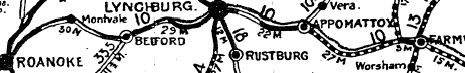
VA 10 Roanoke to Farmville
By 1923 it appears VA 10 was straightened out east of Appomattox to Evergreen to use modern US 460.
It appears that VA 10 was removed from SR 661 in the Blue Ridge area in favor of US 221-460 in 1925 or 1926. Also in that timeframe, VA 10 was placed on modern US 460 east of Lynchburg instead of SR 609/658. Additionally, VA 10 was rerouted in the Goode-Forest corridor to use US 221 and SR 646 through Norwood.
In 1927, VA 10 from Lynchburg to Farmville became partnered with US 60. Also by 1927, VA 10 was placed on modern US 460 between Evergreen and Flood.
In 1928, VA 10 was placed on current US 221-460 in the Irving area leaving behind CR
About 1929, VA 10 was rerouted to cut south from Main St onto 12th St then southeast on Campbell Ave to today's US 460 Business. VA 10 then headed out of Lynchburg on today's US 460.
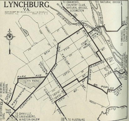
VA 10 original Lynchburg routing.
|
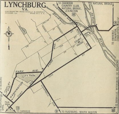
VA 10 (US 60) rerouted in Lynchburg
|
Also by 1929, VA 10 was placed on modern 460 in the Prospect area.
In July 1933, VA 10 from Roanoke to Farmville was renumbered as part of US 460. The draft 1933 route log had this becoming US 221 and VDOH actually requested US 86.
Farmville to Petersburg:
VA 10 in Farmville itself followed today's US 460 Business.
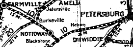
VA 10 followed US 460 east of Farmville, then dipped south on today's SR 600 through Rice, then southeast on SR 735 to modern US 460. VA 10 followed US 460 to Burkeville except it used the SR 736 loop. At Burkeville, VA 10 used SR 716 Namozine St (partly cutoff from US 360-460 now), then US 360 Business 2nd St.
VA 10 followed US 460 through Crewe, then used SR 1006. At Nottoway CH, VA 10 followed US 460 Business, then SR 7xx which is now cutoff by the 460 bypass just past the RR underpass. VA 10 followed SR 625 east and may have initially used this out to SR 611 then back across the Bypass to SR 729, then SR 625 into Blackstone. VA 10 then used US 460 Business east from Blackstone.
VA 10 used SR 641 (no longer a full loop) east of Blackstone. VA 10 picked back up US 460 into Dinwiddie County. At Walkers, VA 10 followed SR 751 through Poole Siding and Church Road, then back to US 460 before Sutherland. VA 10 veered off US 460, using VA 226, then US 460 Business into Petersburg.
In Petersburg, VA 10 used Washington St east to Sycamore St north to Bank St east out of town.
Adjustments:
By 1923, VA 10 cut down to US 460 Business from the SR 611-625 intersection.
In 1927, US 60 joined VA 10 from Farmville to Burkeville.
In 1931, VA 10 was placed on modern US 460 east of Crewe; US 460 Business throughout the Nottoway CH area; US 460 Business east of Blackstone.
The 1933 draft route list had VA 10 west rerouted at Blackstone to head to Victoria, then Keysville (replacing VA 48) and heading west through Rocky Mount and Ferrum (replacing VA 20, before heading northwest to US 221 near Floyd (replacing VA 222). What happened instead is that Burkeville to Keysville became US 360 (though VDOH requested US 33), Keysville past Ferrum became part of VA 40, and the road to Floyd became VA 109
VA 10 Floyd to Petersburg
1933 draft route log
In July 1933, this segment of VA 10 became part of US 460 after VDOH first considering a US 221 extension and actually requesting US 86.
VA 10 Farmville to Petersburg
1924 Official
Petersburg/Richmond to Suffolk:
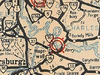
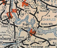
VA 10 followed today's VA 36 to Lee Ave, then went inside Ft Lee. VA 10 followed 'A' Ave as it arc around the Army Post, coming out at the SR 630-634 junction near Prince George CH. VA 10 used SR 634, then VA 106 through Prince George CH, then SR 609 Old Stage Rd. VA 10 followed SR 609 over to current VA 10 Garysville.
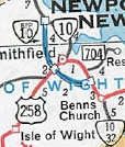
VA 10 followed its current path through Spring Grove and Surry, then used VA 10 Business through Smithfield. VA 10 then picked up VA 10-32 into central Suffolk.
Adjustments:
In Aug 1934 (CTB), VA 10 swapped places with VA 37. VA 37 now ran from Petersburg to Garysville, while VA 10 ran from Richmond to Garysville. VA 10 used today's VA 10 except at Chesterfield used SR 655 to cut the corner and in Chester it used SR 681 approaching Chester. VA 10 followed its current path to Hopewell.
In Hopewell, VA 10 cut east at City Point Rd to Hopewell St. VA 10 then followed the twisted Hopewell St southeast to Teminal St south back to Randolph Rd, current VA 10. VA 10 then followed its current path to Garysville.
In March 1948 (CTB), VA 10 was placed entirely on Randolph Rd in Hopewell.
In 1974, VA 10 was placed on a new Super-2 bypass west around Smithfield.
VA 10 Petersburg to Garysville
|
VA 10 Richmond to Garysville
|
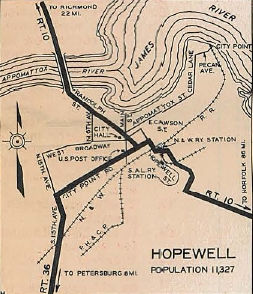
VA 10 zig-zagged through Hopewell
|
Suffolk to Virginia Beach:
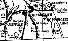
This segment's early alignment is obtained from the 1919 Topo Maps of the area. VA 10 was 100% duplexed with VA 12 from Suffolk to Virginia Beach as follows:
VA 10-VA 12 followed VA 337 from Suffolk to Driver, then to Portsmouth along what was then called Suffolk Rd (current VA 337 ALT) to 6th St to High St. The route followed High St towards the ferry to Norfolk. Then the route did a zig-zag using 1st St, London St, then Water St south to Queen St east to the ferry. Once in Norfolk, the route picked up Bank St over to Princess Anne Rd over to Battery Rd (this is just east of Park Ave and may not exist now) and then to Broad Creek Rd (this is Virginia Beach Blvd).
The route followed Virginia Beach Blvd to Witchduck Rd. Then two possibilities existed - current Va Beach Blvd east to Happy Rd to Bonney to Rosemont OR it used Euclid, Alicia, Baxter and Bonney Rds (broken up by I-264 today) to get to Rosemont.
|
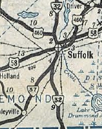
VA 10 Suffolk to Virginia Beach
|
The route ran northeast of today's US 58 on destroyed routing to use either Alcott or Edinburgh Dr to get over to Lynnhaven Rd. The route used Lynnhaven Rd southeast to Lynnhaven, then ran through today's I-264/Lynnhaven Pkwy interchange to connect with today's Potters Rd at Wesley Dr.
The route followed Potters Rd east to First Colonial Rd, then north on that across US 58 Bus to I-264. At that time, a road went due east and connected with today's "Old Virginia Beach Rd." VA 10-VA 12 followed this until it became 23rd Ave on over to the waterfront. Today this is broken up by I-264 right by the Great Neck Creek bridge near Birdneck Rd and now requires passing through the parking lot of the Contemporary Art Center of Virginia.
Adjustments:
In 1923, VA 12 was removed from the entirety of the VA 10 duplex east of Suffolk. About that time VA 10 was placed on Virginia Beach Blvd all the way out to the oceanfront, so VA 10-VA 12 was downgraded to Princess Anne CRs 114, 202, 205, 115, 213, 2, 109 and 210
In 1927, US 117 was added to all of VA 10 east of Suffolk.
The draft 1933 route log showed VA 10 rerouted at Norfolk to instead head to Lynnhaven, replacing VA 12. Instead this became US 460 after VDOH requested US 86.
In July 1933, VA 10 east from Suffolk to Portsmouth became US 460 while Portsmouth to Virginia Beach became part of US 58.
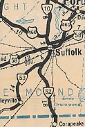
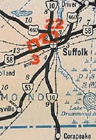
In 1935, VA 10 was extended south from Suffolk to the North Carolina line near Corapeake, NC, replacing VA 52.
In Sept 1940, VA 10 was truncated back to its current ending, replaced by VA 32.
VA 10 truncated to Suffolk
|
VA 10 extended to N.C.
|
VA 10 truncated to Suffolk
|
Improvements: By 1923, VA 10 was paved: Cumberland Gap to Rose Hill; Beech Spring to the Scott County Line; Clinchport to Gate City; Bristol to Radford; Roanoke/Montgomery Line to Webster; A few miles east Bedford; Forest to Lynchburg; a few miles at Appomattox; Dowdys Corner to Farmville; Petersburg area; Suffolk to Virginia Beach
In 1924, VA 10 was paved Rose Hill to Beech Spring; Radford to Christiansburg; Concord to Appomattox;
BY 1926, VA 10 was paved from Christiansburg to Roanoke County; Webster to Bedford County; Bedford to Forest; Lynchburg to Concord;
In 1927, VA 10 was paved a few miles east of Farmville;
In 1928, VA 10 was paved from Roanoke/Bedford line to Thaxton
In 1930, VA 10 was paved Thaxton to Bedford
In 1932, VA 10 was paved from Farmville to Suffolk
When VA 10 was truncated in 1933 it became fully paved (Gate City to Bristol and Clinchport west to Lee County were still unpaved in 1933).
VA 10 was first multilaned in 1941 on its US 460 duplex in Suffolk.
In 1962, VA 10 was 4-laned from I-95 to Hopewell.
VA 10 was multilaned on its VA 161 duplex in 1964.
In 1974, VA 10 was multilaned from US 1-301 to I-95.
In 1975, VA 10 was widened from Chesterfield to SR 681 west of Chester; Hopewell to VA 106-156
In 1977, VA 10 was widened from Benns Church to VA 10 Bus
In 1980, VA 10 was widened from Benns Church to the Suffolk line
In 1983-84, VA 10 was widened from VA 161 south to Walmseley Blvd; around the VA 150 jct
In 1986, VA 10 was widened from Walmseley Blvd to VA 150.
In 1991, VA 10 was widened from VA 288 to Chesterfield; SR 681 Chester to US 1-301
In 1992, VA 10 was widened from VA 288 to VA 150.
In 1993-94, VA 10 was widened from US 460 Bus to Western Branch
In 1998, VA 10 was widened across the Appomattox River
Posted: Fully posted north of US 460 Bus; Cutouts in Richmond and Hopewell replaced around 2000; cutout in Surry replaced mid-90s ; 3-digit shield in Hopewell; VA 10 Bypass of Smithfield is mostly posted as VA 10 TRUCK;
Multiplexes: VA 161 (0.43 mi)
VA 144 (0.25 mi)
VA 156 Bus (2.40 mi)
VA 106-156 (0.73 mi)
VA 31 (1.04 mi)
US 258 (4.26 mi)
VA 32 (13.04 mi)
US 460 Bus, VA 32 (1.49 mi)
US 13 Bus, US 460 Bus, VA 32 (0.74 mi)
Legislative names: Colonial Trail (SR 609 Garysville to US 258/VA 32 Benns Church) - designated 3/24/30.
Charles Hardaway Marks Bridges (Appomattox River - 4/8/98); Reids Ferry Bridge (W. Br. Nansemond River - 5/16/85); Robert B. Withers Memorial Bridge (Nansemond River - 2/10/36)
Other names: Broad Rock Blvd (Richmond); Iron Bridge Rd (Richmond, Chesterfield Co); Hundred Rd (Chester); West Hundred Rd (Chesterfield Co); Randolph Rd (Hopewell); James River Dr (Prince George Co); Main St (Surry); Old Stage Hwy (Isle of Wight Co); Benns Church Blvd (Isle of Wight Co); Godwin Blvd (Suffolk); Main St (Suffolk)
Scenic Byway: No segments
Comment: VA 10 is quite suburban pretty much everywhere from Richmond to Hopewell. However, it is extremely quiet and rural from Hopewell to Smithfield - it is a viable alternative to use VA 10 as a back door route to either Newport News (via US 258) or Suffolk from I-295.
From 1918-28, VA 10 was the most important route in the state although it didn't go to Richmond or Washington DC (supposedly US route duplex routes were de-posted in 1928 even though they show up on the 1932 County maps and in CTB Minutes). The 1926 Official map listed the distance of VA 10 as 569 miles.
|