ROUTE LOG
US 60: 0 - 0
I-264 (exit 20), US 58 Bus: 3.97 - 3.97
VA 279: 0.14 - 4.11
VA 225: 5.02 - 9.13
VA 190: 1.11 - 10.24
VA 403: 1.33 - 11.57
Norfolk-Virginia Beach Line: 0 - 11.57
VA 165: 0.93 - 12.50
US 13: 0.79 - 13.29
VA 405: 2.23 - 15.52
VA 166: 0.96 - 16.48
VA 168: 0.53 - 17.01
US 460: 0.70 - 17.71
VA 337 WB, VA 337 ALT: 0.48 - 18.19
VA 337 EB, VA 337 ALT BEGIN: 1.09 - 19.28
Portsmouth-Norfolk Line: 0.47 - 19.75
VA 164 WB: 1.16 - 20.91
VA 141, VA 164 EB: 0.77 - 21.68
US 17: 0.91 - 22.59
US 460 ALT EB, VA 337: 1.40 - 23.99
VA 239: 0.28 - 24.27
Chesapeake-Portsmouth Line: 1.79 - 26.06
US 13 NB, US 460 EB, US 460 ALT END, VA 191: 1.72 - 27.78
I-664 (exit 13): 0.64 - 28.42
Suffolk-Chesapeake Line: 2.41 - 30.83
US 13 Bus, US 58 Bus, US 460 Bus: 3.46 - 34.29
VA 10, VA 32 NB, VA 32 Bus: 4.17 - 38.46
US 460 WB, US 460 Bus: 0.93 - 39.39
US 13 SB, US 58 Bus, VA 32 SB: 3.29 - 42.68
VA 390: 8.04 - 50.72
US 58 Bus: 0.30 - 51.02
VA 189 NB: 1.11 - 52.13
VA 272: 4.17 - 56.30
US 258 NB, VA 189 SB: 1.26 - 57.56
Southampton-Suffolk Line: 1.20 - 58.76
US 258 SB, US 258 Bus: 3.02 - 61.78
US 58 Bus: 3.74 - 65.52
US 58 Bus: 2.50 - 68.02
US 58 Bus, VA 35: 3.46 - 71.48
VA 308: 8.51 - 79.99
Greensville-Southampton Line: 13.05 - 93.04
Emporia-Greensville Line: 1.50 - 94.54
US 58 Bus: 0.40 - 94.94
US 301: 1.78 - 96.72
US 58 Bus: 0.50 - 97.22
I-95 (exit 11): 0.34 - 97.56
Greensville-Emporia Line: 0.62 - 98.18
Brunswick-Greensville Line: 6.34 - 104.52
US 58 Bus: 9.96 - 114.48
US 58 Bus, VA 46: 2.97 - 117.45
Mecklenburg-Brunswick Line: 10.32 - 127.77
I-85 (exit 12): 4.84 - 132.61
US 58 Bus: 0.24 - 132.85
US 1 NB, US 58 Bus: 3.66 - 136.51
US 1 SB: 3.15 - 139.66
VA 4: 4.23 - 143.89
VA 386: 4.87 - 148.76
US 58 Bus: 0.46 - 149.22
VA 92: 0.46 - 149.68
US 58 Bus: 0.80 - 150.48
VA 364: 7.75 - 158.23
US 15, US 58 Bus, VA 49 NB: 0.65 - 158.88
US 15: 2.42 - 161.30
US 58 Bus: 1.72 - 163.02
VA 49 SB: 1.00 - 164.02
Halifax-Mecklenburg Line: 5.95 - 169.97
US 360 EB: 10.57 - 180.54
US 501: 0.70 - 181.24
VA 119: 15.83 - 197.07
Pittsylvania-Halifax Line: 3.48 - 200.55
VA 62: 3.32 - 203.85
Danville-Pittsylvania Line: 2.37 - 206.22
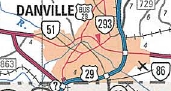
US 29 NB, US 58 Bus, US 360 WB, VA 785 BEGIN: 2.88 - 209.10
VA 86: 3.21 - 212.31
US 29 SB, US 29 Bus, VA 785 END: 3.75 - 216.06
Pittsylvania-Danville Line: 0.44 - 216.50
US 311: 4.62 - 221.12
US 58 Bus: 2.20 - 223.32
Henry-Pittsylvania Line: 9.05 - 232.37
US 58 Bus: 5.38 - 238.75
US 220 SB, US 220 Bus: 6.57 - 245.33
US 58 Bus, US 220 NB: 3.49 - 248.82
Patrick-Henry Line: 8.44 - 257.26
US 58 Bus: 14.00 - 271.26
US 58 Bus, VA 8 SB: 1.55 - 272.81
VA 8 NB: 2.01 - 274.82
US 58 Bus: 10.53 - 285.35
US 58 Bus: 3.14 - 288.49
Floyd-Patrick Line: 0.68 - 289.17
Carroll-Floyd Line: 1.57 - 290.74
US 221 NB: 16.34 - 307.08
US 52: 0.60 - 307.68
I-77 (exit 14): 2.12 - 309.80
Galax-Carroll Line: 7.02 - 316.82
VA 89: 3.15 - 319.97
Grayson-Galax Line: 1.77 - 321.74
VA 94: 1.36 - 323.10
VA 274: 8.68 - 331.78
US 21, US 221 SB: 2.75 - 334.53
VA 93: 11.65 - 346.18
VA 16 SB: 1.04 - 347.22
VA 16 NB: 3.99 - 351.21
VA 362: 7.75 - 358.96
Washington-Grayson Line: 9.57 - 368.53
VA 91 SB: 15.43 - 383.94
VA 91 NB: 0.99 - 384.93
US 11 NB: 10.48 - 395.41
I-81 NB (exit 19), US 11 SB: 0.30 - 395.71
US 58 ALT, VA 75: 2.49 - 398.20
VA 140: 2.07 - 400.27
Bristol-Washington Line: 6.83 - 407.10
US 11, US 19: 3.06 - 410.16
I-381 (exit 1): 1.39 - 411.55
I-81 SB (exit 1), US 421 SB: 2.44 - 413.99
Washington-Bristol Line: 0.50 - 414.49
Scott-Washington Line: 6.24 - 420.73
VA 224: 17.42 - 438.15
US 23 SB: 0.38 - 438.53
US 23 Bus, US 58 Bus, US 421 Bus: 0.96 - 439.49
US 23 Bus, US 58 Bus, US 421 Bus: 2.73 - 442.22
VA 65: 9.49 - 451.71
US 23 NB: 4.67 - 456.38
Lee-Scott Line: 4.75 - 461.13
US 421 NB: 6.00 - 467.13
VA 70: 8.71 - 475.84
US 58 ALT: 0.44 - 476.28
US 58 Bus: 14.21 - 490.49
US 58 Bus: 6.84 - 497.33
TN STATE LINE: 12.31 - 509.64
|
|
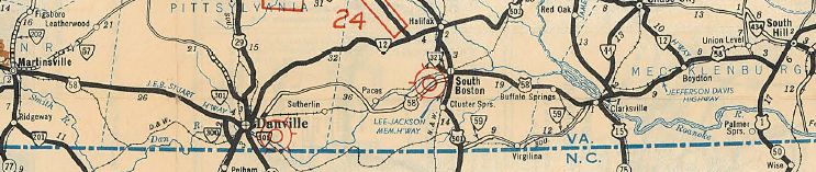
Creation: The corridor from Hillsville to Virginia Beach was requested as a US Route by Virginia on May 14, 1931 (AASHO). This was approved and the number US 58 was formally assigned July 1, 1931 (AASHO), running from US 121-221 Hillsville to
Virginia Beach via Martinsville, Danville, South Hill, Emporia,
Suffolk, Portsmouth and Norfolk. In this routing, US 58 was added to:
VA 12 from Hillsville to Danville.
VA 44 from Danville to Clarksville.
VA 400 from Clarksville to Boydton.
VA 12 from Boydton to Norfolk.
VA 10 from Norfolk to Virginia Beach.
Note that Clarksville to South Hill was a replacement for US 401.
In May 1933 (AASHO), US 58 was extended west to Cumberland Gap, replacing:
A duplex with US 221 from Hillsville to Independence
VA 12 from Independence to Abingdon
A duplex with US 11 from Abingdon to Bristol
US 421 and VA 10 from Bristol to Clinchport (really! See US 411 page for details.)
A duplex with US 23 from Clinchport to Duffield
VA 142 from Duffield to Pattonsville
US 421 and VA 10 from Pattonsville to Dot
VA 103 from Dot to just short of Jonesville (gap in route)
VA 103Y through Jonesville.
US 421 and VA 10 from Jonesville to end at US 25E Cumberland Gap.
Here is a more detailed look at the history of US 58 from a geographic standpoint.
Cumberland Gap to Bristol
US 58 initially followed what is now a restored trail through the
Cumberland Gap Historic Area. It used SR 872, then an unnumbered road
that parallels the modern US 58 to the north eastward. The route used
the SR 912 loop, then maybe modern US 58 but there is what looks like
an old alignment on satellite photo that is not a road today.
US 58 used SR 732 through the old Gibson Station area, then the
piece of SR 692 that is north of US 58. The route may have followed
modern US 58 over to Wheeler, then SR 729. The route then seems to have
followed modern US 58 to Kesterson Mill.
US 58 followed SR 684 routing south of US 58, but not north of it
unless it was before 1927. The route followed US 58 Business through
Ewing. The route likely used SR 697 and SR 672 to go to Rose Hill.
US 58 followed modern US 58 until SR 670, then used the SR 813
loop to Henegartown. The route used a small bit of SR 621 and all of SR
814 in the Russels Store area. Continuing east the route used SR 946
(except used the SR 815 loop), then SR SR 899 and SR 880 down to Cony
Hollow.
US 58 followed modern US 58 from here to Jonesville except used
the SR 836 and SR 745 loops. East of Jonesville, US 58 followed its
current route, then SR 915 off Wallen Ridge, then SR 702 to
Stickleyville. Then it used US 58-421 over Powell Mountain, then headed
south on SR 638 through Pattonsville and east on SR 604 then modern
58-421 to Duffield. US 58 then followed SR 871 through Natural Tunnel
back to modern US 58 via SR 872. US 58 used SR 882, abandoned routing,
SR 883 and VA 65 west.
Note that the June 1933 CTB approved requesting AASHTO to have US
58 routed via Pennington Gap. Apparently that request didn't actually
happen or was denied.
US 58 then followed US 23-58-421 past Speers Ferry, then used SR
870 to Gate City. US 58 followed Bus 23-58-421 through Gate City, then
picked up mainline US 23-58-421. Before Weber City, US 58 veered off at
today's SR 619. This road used to be continuous over to today's US
58-421 east of VA 224 but it is now a VDOT maintenance yard. From
there, US 58 followed its current route to I-81.
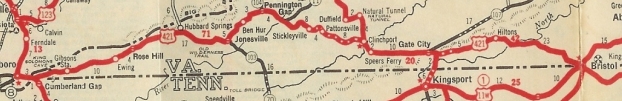
US 421 Bristol to Cumberland Gap.
1932 Texaco
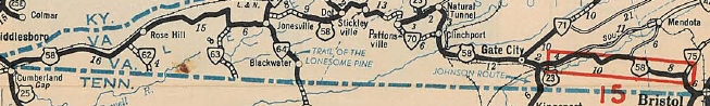
US 58 out to Cumberland Gap in 1933.
1933 Official
Adjustments:In Aug 1933 (CTB), the 0.5 mile gap in US 58 at the east edge of Jonesville was put into the primary highway system.
In May 1942 AASHO denied a June 1941 request by Tennessee to extend US 58 south to Chattanooga.
In June 1956 AASHO denied a Nov 1955 request by Kentucky and Illinois to extend US 58 west to the Misouri State Line at St Louis via Mammoth Cave NP and the Shawneetown bridge over the Ohio River.
In June 1957 AASHO deferred an identical May 1957 extension request from the year before.
In June 1961 AASHO rejected a third attempt to extend US 58 to the St Louis area. The proposal scored 65 and 70 was needed to approve. The main deficiency was too much of the routing was still substandard.
In Oct 1966 (CTB), US 23-58-421 was placed on a newly constructed bypass of Gate City, leaving behind US 23-58-421 Business.
In Jan 1970 (CTB), US 23-58-421 was placed on newly constructed road west of Gate City, leaving behind SR 870.
In Feb 1970 (CTB), US 23-58-421 was placed on a new alignment
(partially over SR 646) between Clinchport and Duffield, leaving behind
SR 871.
In Aug 1972 (CTB), US 58-421 was placed on newly constructed road
to avoid Pattonsville and run directly to US 23 Duffield. This left
behind a bit of SR 638 and some SR 604.
US 58 initial route
1969 Official
|
US 58 avoids Sunbright
1971 Official
|

US 58 avoids Pattonsville
1974 Official
|
In March 1994 (CTB), US 58 was put on its current routing over Wallen Ridge west of Stickleyville, leaving behind SR 915.
In Nov 1998 (CTB), US 58 was rerouted to dip into Tennessee. This
followed what had been the US 25E corridor south from Cumberland Gap.
The old road became SR 972 and partly restored wilderness area (Sept
2000 CTB).
In July 2000 (CTB), US 58 was put on a new bypass of Rose Hill-Ewing, leaving behind US 58 Business.
Bristol
US 58 initially entered Bristol along today's US 421 south to State
St east, then north on Piedmont St and Myrtle St (now Oakview Ave) to
current US 11-19 north out of town. In this alignment, US 58 EB was
technically in Tennessee on State St.
In May 1952 (CTB), US 58 was rerouted in Bristol to be one one-way
splits. Westbound was not changed. Eastbound used State St east to 9th
St (now Volunteer Pkwy), then south into Tennessee to Shelby St east to
7th St north which turns into Piedmont at State St.
It appears in Oct 1966 (CTB), US 58 was moved onto I-81, leaving behind US 421 into Bristol and US 11-19 exiting Bristol.
US 58 initial route
1933 Official
|
US 58 splits in Bristol
1961 Official
|
US 58 moved to I-81
1969 Official
|
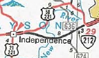
Bristol to Independence
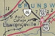
US 58 initially used today's US 11 approaching Abingdon, then used
Colonial Ave and crossed the railroad to modern US 11 at roughly the
Bytt St location, then current US 11 to Scotts Addition (just past
Abingdon), then today's US 58 to Damascus except used Minton Ln near
Osceola; Drowning Ford Rd near Delmar; Blossom/Hollyfield Rds. through
Roetown and Valis Mill.
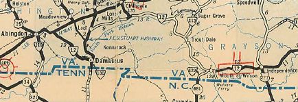
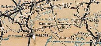
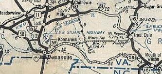
At Damascus, US 58 followed current VA 91 north to Lodi (used
Librty Hall Dr loop), then east on SR 762 to St. Clair Bottom, then SR
660 to SR 650 which US 58 followed south to Holston Mill and continued
on SR 650 all the way to current VA 16. US 58 then followed VA 16
through Troutdale and probably used SRs 836-739 and SR 737 through the
Grants area, then followed VA 16 down to Mouth of Wilson.
US 58 essentially used its current routing from Mouth of Wilson to Independence.
Adjustments: In July 1937 (CTB), US 58 was removed from Colonial Ave in western Abingdon and given US 11's current Abingdon routing.
In Oct 1940 (CTB), US 58 was rerouted from Damascus to Mouth of Wilson to the current US 58 route, replacing VA 305. Damascus to Lodi became VA 91; Lodi to near Troutdale became VA 81; Troutdale to Mouth of Wilson became VA 16
In Oct 1966 (CTB), US 58 was placed on I-81 from Bristol to Scotts Addition, leaving behind US 11.
VA 12 Abingdon to Independence
1932 Official
|
US 58 initial route
1938-39 Official
|
US 58 rerouted
1941-42 Official
|
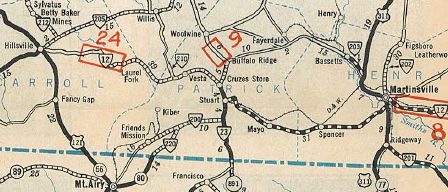
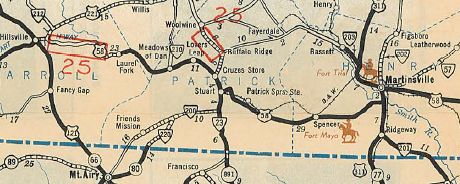
Independence to Martinsville
US 58 followed today's US 58-221 to VA 274 over to VA 94 east to SR
882. It used SR 882, then W. Stuart Dr (makes a 90 degree turn at
MacArthur) back to US 58-221 to Glendale Rd out of Galax and on SR 887
out to near Woodlawn before using US 58-221 into Hillsville.
US 58 used its current route plus US 58 Business through Meadows
of Dan. Towards the east end of Lover's Leap, US 58 used SR 870 Greasy
Bend Ln, but used US 58 and 58 Business into Stuart. East of Stuart, US
58 followed SR 765 Rhody Creek Loop; US 58; Campbell Farm Loop; US 58;
SR 777; US 58; SR 625 Mt. View Loop; US 58; SR 657/827 S. Fork Loop; US
58; SR 700 through Netteridge; SR 832 Golf Course Rd through Trent
Store; SR 701/854 Stella Loop to Penns Store.
In Henry County, US 58 used SR 630; Maple Leaf Rd; SR 695 Spencer
Penn Rd to Spencer; US 58; SR 759 Evergreen Dr; US 58; Arrowhead
Circle; US 58; several SR 87x loops; 58 Business essentially from
Horsepasture to US 220 Business (which back then as VA 33 ran just east
of the overpasses). US 58 followed US 58 Business into eastern
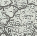
Martinsville.
In Martinsville, US 58 used Broad St north to Church St east.
VA 12 Independence to Martinsville
1931 Official
|
US 58 Hillsville to Martinsville
1932 Official
|
Adjustments: Between 1937-58, US 58 was removed from Broad St and put on Starling St in Martinsville.
In Aug 1958 (CTB), US 58 was removed from SR 887 Glendale Rd east of Galax; also US 58 was removed from Henry SR 630 and SR 759.
In Jan 1959 (CTB), US 58 was placed on its modern routing from Stuart to east of Patrick Springs.
In Jan 1962 (CTB), US 58 was placed on its modern routing in eastern Patrick County leaving behind SR 832 and nearby loops.
In Jan 1970 (CTB), US 58 was removed from W. Stuart Drive in Galax
In Nov 1979 (CTB), US 58 was placed on its current route between Independence and VA 94 (replacing VA 212), leaving behind VA 274 and an extended VA 94.
US 58-221 original route
1978 Official
|
VA 212 replaced by US 58-221.
1980 Official
|
In Aug 1982 (CTB), US 58 was placed on its current Lovers Leap eastern side leaving behind SR 870.
In April 1993 (AASHTO), US 58 was placed on US 220 around the south of
Martinsville, then along new freeway to the east side of town. This
left behind US 58 Business.
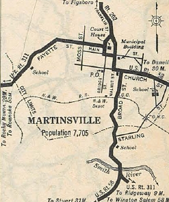
US 58 original Martinsville routing.
1932 Official
|
US 58 moved to Starling
1958 Henry County
|
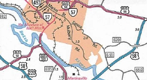
US 58 bypasses Martinsville
1994-95 Official
|
In 2004 (AASHTO), US 58 was placed on new expressway construction around the north side of Stuart, leaving behind US 58 Business.
In 2006, US 58 was placed on new routing to the north of Meadows of Dan, leaving behind US 58 Business.
In August 2011, US 58 was placed on new freeway around the south side of Hillsville, leaving behind US 58 Business.

US 58 bypasses Stuart
2006 Official
|

US 58 bypasses Meadows of Dan
2006 Official
|
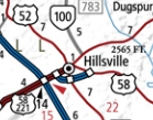
US 58 bypasses Hillsville
2012 Official
|
Martinsville to South Hill
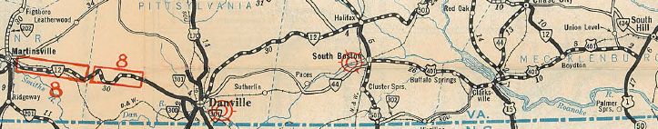
US 58 followed its current routing east of the Martinsville bypass,
then picked up VA 51. At the east end of VA 51, US 58 crossed the Dan
River and used what is now VA 413 to central Danville. US 58 then
crossed back over the river on today's VA 293 to pick back up US 58
Business east out of Danville.
US 58 followed its current routing through South Boston.
Approaching Clarksville, US 58 used SR 750 east to 8th St then south to
US 58 Business which it followed through town.
Multiple route numbers from Martinsville to South Hill
1931 Official
US 58 from Martinsville to South Hill
1932 Official
Adjustments:In April 1940 (CTB), US 58 was placed on its
current US 58/58 Bus routing west of Clarksville (upgrade to SR 723)
leaving behind SR 750.
US 58 original Boydton routing.
1936 Mecklenburg County
|
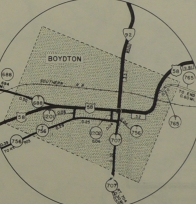
US 58 modern Boydton routing.
1946 Mecklenburg County
|
In June 1942 (CTB), US 58 was placed on its modern US 58 Bus
routing on the west side of Boydton, leaving behind SR 756 and SR 707.
US 58 original Clarksville routing.
1936 Mecklenburg County
|
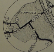
US 58 modern Clarksville routing.
1946 Mecklenburg County
|
In Aug 1947 (CTB), US 58 was placed on Riverside Dr instead of
crossing the Dan River to today's VA 413 and crossing back over on the
Union St Bridge. This was a replacement for US 58 ALT.
In Oct 1954 (CTB), US 58 was placed on its current US 58 Business
routing in western Danville, replacing US 58 ALT. The old routing
became VA 51.
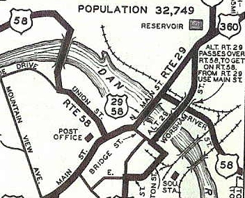
US 58 original Danville routing.
1941-42 Official
|
US 58 later on.
1958 Pittsylvania County
|
In July 1978 (CTB), US 58 was placed on new construction around the north of Boydton, leaving behind US 58 Business.
In 2002, US 58 was placed on new construction to the south and east of South Hill, leaving behind US 58 Business.
In 2005, US 58 was placed on its southern bypass of Danville. This
utilized the existing US 29 freeway plus new construction. The old
route became US 58 Business.
In 2006, US 58 was placed on new freeway to the south of Clarksville, leaving behind US 58 Business.

US 58 bypasses Boydton
1980 Official
|

US 58 bypasses South Hill
2002 Official
|
US 58 bypasses Danville
2006 Official
|

US 58 bypasses Clarksville
2006 Official
|
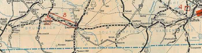
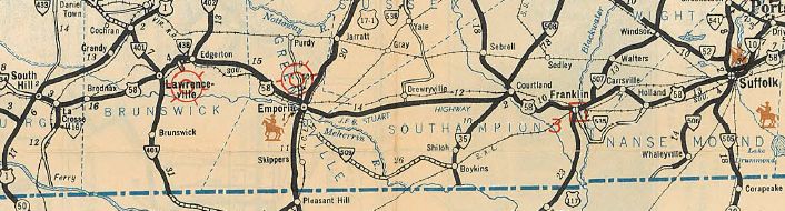
South Hill to Suffolk
US 58 used High St/Main St/Pine St through La Crosse, then current
US 58 and US 58 Business into Lawrenceville. US 58 then used its
current route until just before I-95, where it ran on West End Dr (now
cutoff by I-95). In Emporia it used Atlantic St to Halifax St south,
then Southampton St east back out to today's 58 Business.
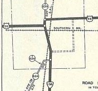
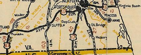
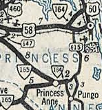
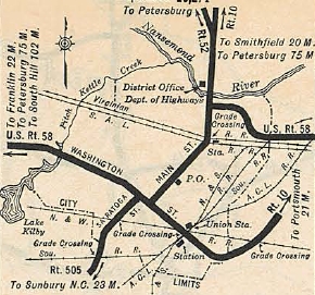
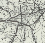
US 58 followed today's 58 to Suffolk, except it used 58 Business
through Courtland, Franklin and Holland. Approaching Suffolk, US 58
used 58 business, then VA 337 to downtown Suffolk, then VA 10 north
back to current 58 Business.
VA 12 and US 117 from South Hill to Suffolk
1931 Official
US 58 from South Hill to Suffolk
1932 Official
Adjustments: I could not find a reference but per county maps, US 58 was rerouted in downtown Emporia to the current US
58 Business east of Halifax St. between 1941-46.
US 58 original Emporia routing.
1936 Greensville County
|
US 58 modern Emporia routing.
1946 Greensville County
|
In Oct 1945 (CTB), US 58 was rerouted in Franklin to use Clay St to 4th to Mechanic St to 2nd.
In May 1953 (CTB), US 58 was removed from Washington St in Suffolk
and placed on new construction, Constance St. Washington St became VA 337.
In Oct 1957 (CTB), US 58 was given its current routing through La Crosse.
US 58 original LaCrosse routing.
1936 Mecklenburg County
|
US 58 modern LaCrosse routing.
1958 Mecklenburg County
|
In June 1963 (CTB), US 58 was given a freeway bypass south of Lawrenceville, leaving behind US 58 Business.
In Feb 1970 (CTB), US 58 was rerouted in Franklin to use Clay St to
Lee St to High St to 4th to Mechanic to 2nd. This CTB reference clearly
takes Clay St out of the primary system but today's traffic logs show
US 58 Bus as on one-way splits in this area. I cannot find a reference
when that occurred.
In 1982, US 58 was placed on the partially completed Franklin bypass, replacing VA 280,
which ended at a temporary access to SR 714. US 58 then followed SR 714
south to VA 189 then east over what is now VA 272 to pick up modern US
58. The old route through Franklin, Carrsville and Holland became US 58
Business. This was approved by AASHO in June 1970!
In 1983 or so, US 58 was placed on the rest of the
Franklin-Holland Bypass. The access to SR 714 was closed until an
interchange was built in 1996.
About May 1985 (AASHTO correspondence), US 58 was given its bypass south of Courtland, leaving behind US 58 Business. This was approved by AASHO in May 1970!
In Dec 1987 (CTB), US 58 was given its northern bypass of Emporia, leaving behind US 58 Business and a little W. Atlantic St.
US 58 bypasses Lawrenceville
1965 Official
|
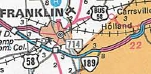
US 58 bypasses Franklin/Holland
1984-85 Official
|

US 58 bypasses Courtland
1986 Official
|
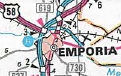
US 58 bypasses Emporia
1989 Official
|
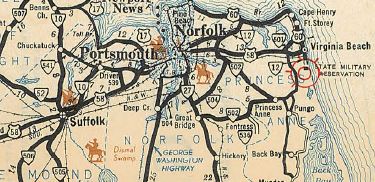
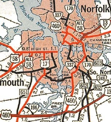
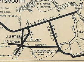
Suffolk to Virginia Beach
Originally, US 58 followed (removed) Orchard St, then south on Katherine St and East on Pinner St east from Suffolk
through Bowers Hill to Alexander's Corner in Portsmouth. It then
followed today's VA 337 ALT Turnpike Rd to 6th St (now Constitution
St.) to High St. US 58 followed High St east to the ferry across the
Elizabeth River.
On the Norfolk side of the river, US 58 picked up Bank St north to
Princess Anne Rd (not possible now), then east to Park Ave then
southeast over a road that is not there anymore. US 58 then used
today's US 58 and US 58 Business along Virginia Beach Blvd to end at
17th and Atlantic, US 60.
US 117 from Suffolk to Virginia Beach
1926 Official
|
US 58 from Suffolk to Virginia Beach
1932 Official
|
Adjustments: In Aug 1933 (CTB), US 58 was removed from today's VA 337
ALT and instead used today's US 58 and Airline Blvd to High St. The old
route became VA 287. Airline Blvd had briefly been part of US 460.
In Nov 1943 (CTB), US 58 was removed from Holt/Church St/Princess
Anne Rd in Norfolk to instead use Lovitt Ave/Park Ave to reach Virginia
Beach Blvd. Maps suggest the old US 58 became US 58 ALT.
US 58 initial route
1936 Official
|
US 58 rerouted in Norfolk
1947 Official
|
In May 1953 (CTB), US 58 was removed from Washington St in Suffolk (became part of VA 337) and Main St (remained VA 10) and placed on the new Constance St bypass around downtown.
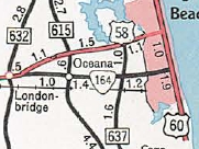
In July 1955 (AASHO), US 58 was moved to Laskin Rd in a swap with VA 164.
US 58 now ended at 31st St at Atlantic Ave. Virginia Beach Blvd east of
Laskin is now US 58 Business and 17th St between Pacific and Atlantic
Aves is technically US 60.
US 58 on Va Beach Blvd
1941-42 Official
|
US 58 moved to Laskin Rd
1956 Official
|
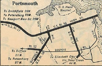
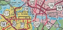
In Oct 1957 (CTB), US 58 in Suffolk was moved onto Constance St east of Main, leaving behind Katherine and Pinner Sts (now also E Old Pinner).
In Nov 1957 (CTB), US 58 was rerouted in Portsmouth to leave High
St using Washington St south to the entrance to the Downtown Tunnel,
then through the tunnel, then City Hall Ave to Tidewater Dr to Virginia
Beach Blvd.
In May 1958 (CTB), US 58 east was officially truncated to Pacific
Ave and the relocated US 60. However, US 58 continued to be posted as
if it ended at Atlantic well into the 1990s.
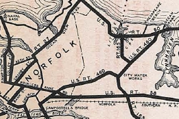
In Aug 1962 (CTB), US 58 was rerouted off High St/Washington St to
use Hamilton/Glasgow Sts (now London Blvd), then north to the new
Midtown Tunnel, then Brambleton Ave east in Norfolk to Bank St north to
Virginia Beach Blvd, all this replacing the briefly designated VA 150.
US 58 initial Portsmouth route
1932 Official
|
US 58 moved to Airline Blvd
1935 Official
|
US 58 moved to
Midtown Tunnel/Brambleton Ave
1963 Official
|
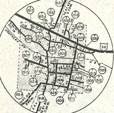
In Oct 1974 (CTB), US 58 was placed on the freeway bypass north
around downtown Suffolk, much of which had already opened as US 460
Bypass earlier. The old route in Suffolk became US 58 Business. AASHO approved this in June 1970.
US 58 initial Suffolk routing
1932 Official
|
US 58 rerouted
1958 Nanesmond County
|
US 58 bypasses Suffolk
1975 Official
|
Improvements: The following segments of US 58 were paved upon designation in 1932:
Laurel Fork to east of Danville; South Boston to Virginia Beach
In 1933, The entirety of the original US 58 route from Hillsville
to Virginia Beach was paved. The extension to Cumberland Gap had the
following paved segments: Cumberland Gap to Jonesville; about Powell
River Bridge to Scott County Line; Pattonsville to Lodi; Mouth of
Wilson to Hillsville
In 1936, US 58 was paved Jonesville to Powell River and Scott Line to Powellsville.
About 1937, US 58 was paved from Troutdale to Mouth of Wilson
When US 58 was moved in 1940 to Damascus-Konnarock-Mouth of Wilson, it was not paved on that segment anywhere.
In 1947, US 58 was paved from VA 16 west about 7 miles.
In 1950, US 58 was paved further west to the Washington County line
In 1953, US 58 was paved from Damascus to Grayson County, finally making all Virginia US Routes fully paved.
The earliest multilaning of US 58 occurred between 1942-47, from Magnolia to Bowers Hill.
In 1949, US 58 was multilaned from Danville east to SR 729.
In 1950, US 58 was multilaned from then-ECL Norfolk to Witch Duck Rd.
In 1951, US 58 was multilaned: Gate City to Weber City; High St in Portsmouth; Park Ave to ECL Norfolk
In 1952, US 58 was multilaned from Witch Duck Rd east to Laskin Rd
In 1954, US 58 was multilaned from SR 729 to VA 62.
In 1955, US 58 was multilaned from VA 62 east to Halifax Co
In 1956, US 58 was widened from Pittsylvania-Halifax Line east across the Dan River; all of Laskin Rd
In 1957, US 58 was widened from Dan River to about Turbeville.
In 1958, US 58 was widened from Danville west to SR 863; Turbeville east 4 miles; Franklin west a mile
In 1960 or 1961, US 58 was multilaned through Martinsville; Turbeville +4 to South Boston; Suffolk to Magnolia
In 1962, US 58 was widened from SR 863 west to SR 622 in Pittsylvania County
In 1963, US 58 was multilaned from SR 622 west to Henry County; new
Portsmouth through Norfolk via MLK Fwy and Brambleton, except for the
Midtown Tunnel.
In 1964, US 58 was widended from Martinsville to Pitsylvania County except not around Axton.
In 1966, US 58 was multilaned when added to I-81; through Axton; VA 46 west 3 miles
In 1967, US 58 was 4-laned from Broadnax to VA 46 -4; near Courtland to Franklin; near Holland to near Suffolk.
In 1968, US 58 was widened 1 mile west from Broadnax
In 1969, US 58 was widened on the new Gate City Bypass plus several miles west; Alexanders Corner to VA 141
In 1970, US 58 was widened on the Sunbright bypass; South Hill to Broadnax
In 1971, US 58 was multilaned on the gap between Sunbright to Gate City; VA 49 west to Halifax County; Edgerton to I-95
In 1972, US 58 was widened from Edgerton west to US 58 Bus.
In 1974, US 58 was 4-laned from South Boston east about 7 miles; Lawrenceville Bypass
In 1975, US 58 was multilaned from current VA 94 to Galax; South
Boston +7 to Mecklenburg County; VA 49 to Clarksville; Suffolk Bypass
In 1978, US 58 was 4-laned from I-77 to Hillsville
In 1982, US 58 was multilaned on its new VA 189 duplex in the Holland area
In 1983 or 1984, US 58 was multilaned from I-77 west 2 miles
In 1985 or 1986, US 58 was multilaned from Galax to I-77 -2
In 1988, US 58 was widened from Capron to VA 35
In 1990, US 58 was multilaned from Capron west to about VA 308.
In 1991, US 58 was multilaned from VA 308 to SR 652.
In 1992, US 58 was widened on most of its US 1 duplex; SR 652 west to US 58 Bus Emporia
About 1993, US 58 was multilaned on Martinsville Bypass; Boydton Bypass; Emporia Bypass; Courtland Bypass; Franklin Bypass
In 1995 or 1996, US 58 was multilaned several miles in the Ewing area and a few miles in the Rose Hill area; Spencer to US 220
In 1997 or 1998, the gap from Ewing to Rose Hill on US 58 was mutlilaned; VA 274 to VA 94
In 1999 or 2000, US 58 was widened from Tennessee to the Ewing
section; Lee SR 659 to near Jonesville; Scott SR 638 to US 23; Patrick
SR 653 to SR 626; a couple miles east from Boydton Bypass
In 2001 or 2002, US 58 was widened from US 15 to Boydton; Boydton +2 to US 1
In 2003, US 58 was widened from Stuart to Spencer
In 2004, US 58 was multilaned from Rose Hill to Lee SR 659.
In 2005, US 58 was multilaned on the Danville Bypass.
In 2006, US 58 was multilaned from Abingdon east 3 miles; Meadows of Dan Bypass; Stuart Bypass; Clarksville Bypass
About 2010, US 58 was multilaned from Abingdon +3 east past the Middle Holston River.
About 2014, US 58 was multilaned from the Middle Holston River section east to Louse Creek.
In 2016, US 58 was multilaned from Meadows of Dan west roughly halfway to Hillsville.
There are significant segments of 6+ lanes on US 58 Suffolk to Bowers Hill; Brambleton Ave
US 58 is 8 lanes from VA 403 east to US 58 Business Virginia Beach
Posted: Fully posted except at its eastern end on the Virginia Beach Oceanfront.
It is unknown if any US 58 cutouts remain on the mainline routing - Konnarock set from 2009 has that era GMSV still up as of 2022.
An error VA 58 shield existed on VA 457 EB in Martinsville at the minor league ballfield. Gone by 2010.
Multiplexes:
VA 337 (1.09 mi)
VA 337 ALT (2.40 mi)
US 460 ALT (3.79 mi)
US 13, US 460 (6.51 mi)
US 13, US 460, VA 32 (0.93 mi)
US 13, VA 32 (3.29 mi)
VA 189 (5.43 mi)
US 258 (4.22 mi)
US 1 (3.15 mi)
VA 49 (5.14 mi)
US 360 (25.70 mi)
US 29 (6.96 mi)
US 220 (3.49 mi)
VA 8 (2.01 mi)
US 221 (27.45 mi)
VA 16 (3.99 mi)
VA 91 (0.99 mi)
US 11 (0.30 mi)
I-81 (18.28 mi)
US 421 [I] (24.54 mi)
US 23, US 421 (18.15 mi)
US 421 [II] (10.75 mi)
Legislative names: A.L. Philpott Memorial Highway,
entire route except 58 Business in Rose Hill and South Hill (since
3/3/92); Edgar Bacon Highway, Tenn. line to US 23 except 58 Bus Rose
Hill (since 3/3/92); Daniel Boone Heritage Trail, from Tenn. line to
Weber City except 58 Bus Rose Hill (since 4/9/88); Trail of the
Lonesome Pine, from US 58 ALT to VA 70 in Jonesville (designation
3/24/30 predates US 58); J.E.B. Stuart Highway, Abingdon to Courtland
except between VA 274 and VA 94; not Danville to Boydton; not 58
Business Lawrenceville, South Hill, Boydton (designation 3/14/28
predates US 58); T. George Vaughan, Jr Memorial Highway, from Galax to
Hillsville (since 3/13/98); Jefferson Davis Highway, Clarksville to
Edgerton (designation 3/17/22 predates US 58); Emory P. Barrow Bypass,
on Lawrenceville Bypass (since 6/27/63);
J.R. Ely Memorial Bridge over Hardy Creek in Lee Co (since
11/15/01); Hugh C. Chance Memorial Bridge over Cave Fork Creek in Lee
Co (since 1/17/02); Poteet Ferry Bridge over Powell River (since
6/19/03); Sgt. Ross S. Carter Memorial Bridge over N. Fork River (since
3/15/01); Veterans Memorial Bridge over New River (since 5/16/02);
Taylor G Vaughan Memorial Bridge over Chestnut Creek in Galax (since
3/9/42); Thos. L Felts Memorial Bridge over Crooked Creek in Carroll Co
(since 2/15/40); PFC Winfred B Branch Memorial Bridge over Rhody Creek
in Patrick Co (since 9/20/01); Frankie Lynn Betterton Memorial Bridge
over US 58 Bus west of Danville (since 8/15/02); Colgate Whitehead
Darden, Jr Bridge over Nottoway River (since 1/21/82); Sol W Rawls
Memorial Bridge over Blackwater River (since 3/19/98)
Other names: Jones St (Jonesville); Duff Pat Hwy
(Scott Co west of US 23); Hilton Rd (Weber City); Bristol Hwy (Scott Co
east of VA 224); Gate City Hwy (Washington Co west of I-81); Douglas Dr
(Damascus); Highlands Pkwy (Grayson Co west of VA 16); Wilson Hwy (VA
16 to Independence); Main St (Independence); Grayson Pkwy (Independence
to Galax); Reserve Blvd/Stuart Dr (Galax); Carrolton Pike (Galax to
Hillsville); Stuart Dr (Hillsville); Danville Pike (Hillsville to
Meadows of Dan); William F Stone Hwy (Martinsville Byp); Danville
Expwy; South Boston Rd (Danville); Bill Tuck Hwy (Halifax Co east of US
501); Atlantic St (South Hill); Piney Pond Rd (Broadnax); Governor
Harrison Pkwy (Brunswick Co); Pleasant Shade Dr (Greensville Co w of
Emporia); Atlantic St (Emporia); Courtland Rd (Greensville Co east of
Emporia); Southampton Pkwy (Southampton Co); Franklin Bypass; Holland
Bypass; Holland Rd (Holland to Suffolk Byp); Suffolk Bypass; Military
Hwy (Suffolk Byp to Bowers Hill); Airline Blvd/London Blvd/Martin
Luther King Fwy (Portsmouth); Brambleton Ave/Duke St/Va Beach Blvd
(Norfolk); Va Beach Blvd/Laskin Rd/31st St (Virginia Beach)
Scenic Byway: Tenn line to Duffield (since 3/8/93); Damascus to SR 604 Konnarock (since 9/21/00)
Comment: For a few years after the shortening of US 290 in
Texas, US 58 had the distinction of being the longest intrastate US
highway in the country - a distinction it lost by being rerouted into
Tennesee at its western end in conjunction with the new Cumberland Gap
tunnel.
US 58 is the longest road within Virginia. It flirts with the
state border for most of its length, but never makes it over until the
very end.
Some maps show US 58 and US 460 multiplexed for a few blocks
between Virginia Beach Blvd. and Brambleton Ave along Granby Street,
though VDOT's traffic log does not show this nor is it signed that way
in the field. US 58 continues west to Duke St. then south to Brambleton
with no US 460 multiplex, while US 460 actually follows Monticello Ave
in that vicinity.
There have been preliminary studies to widen US 58 in its mountanous areas, which will be quite the road-building challenge. The Lovers Leap area started work in Sept 2021.
Before the widenings of US 58 in the 1990s, it was still original
concrete from Clarksville to US 1 and from Emporia to Courtland.
|