< US 9 | Home | US 11E >
US 11 Business | US 11 ALT | US 11Y |
US 211 | US 311 | US 411 | US 511
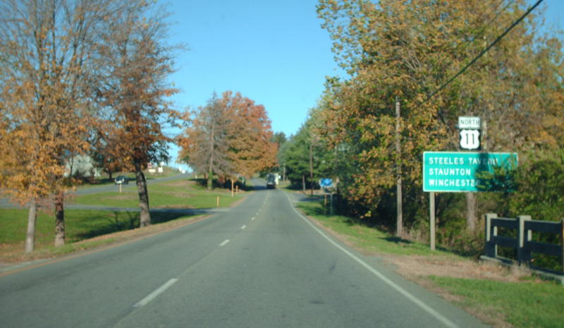
Photo: US 11 north of Fairfield (photo by Mapmikey 10/21/08)
|
|
|
| ROUTE LOG |
US 11E, US 11W, US 19 SB, US 421, VA 381: 0 - 0 VA 113: 1.04 - 1.04 I-81 (exit 5): 1.74 - 2.78 Washington-Bristol Line: 2.55 - 5.33 VA 140: 7.18 - 12.51 US 19 NB: 0.90 - 13.41 US 58 ALT WB: 0.82 - 14.23 US 58 ALT EB, VA 75: 0.24 - 14.47 I-81 (exit 19), US 58 WB: 2.66 - 17.13 US 58 EB: 0.30 - 17.43 VA 80: 4.67 - 22.10 VA 91: 4.46 - 26.56 I-81 (exit 32): 2.81 - 29.37 Smyth-Washington Line: 2.21 - 31.58 VA 107: 1.17 - 32.75 I-81 (exit 39): 4.31 - 37.06 I-81 (exit 44): 4.32 - 41.38 VA 16 SB: 1.99 - 43.37 VA 16 NB: 1.19 - 45.56 I-81 (exit 50): 1.08 - 46.64 Wythe-Smyth Line: 9.57 - 56.21 VA 90: 3.07 - 59.28 I-81 (exit 67): 6.73 - 66.01 US 21 SB: 4.00 - 70.01 US 21 NB: 0.31 - 70.31 VA 365: 0.90 - 71.21 I-77 NB, I-81 SB (exit 73), US 52 NB: 0.99 - 72.20 US 52 SB, VA 121: 5.75 - 77.95 I-77 SB (exit 32): 2.28 - 80.28 Pulaski-Wythe Line: 5.74 - 86.02 I-81 NB (exit 89), VA 100: 2.68 - 88.70 VA 99: 4.90 - 93.60 VA 373: 6.88 - 100.48 VA 100: 0.16 - 100.70 VA 114: 6.83 - 107.53 Montgomery-Pulaski Line: 0.75 - 108.28 Radford-Montgomery Line: 0.15 - 108.43 VA 232: 0.21 - 108.64 VA 177: 1.03 - 109.67 Montgomery-Radford Line: 2.39 - 112.06 VA 8: 4.84 - 116.90 US 460 Bus WB: 0.30 - 117.20 VA 111: 1.21 - 118.41 US 460: 0.86 - 119.27 I-81 (exit 118), US 460 WB, US 460 Bus END: 1.15 - 120.42 Roanoke-Montgomery Line: 12.85 - 133.27 Salem-Roanoke Co Line: 5.82 - 139.09 VA 112: 1.12 - 140.21 US 11 ALT, US 460 ALT: 1.31 - 141.51 US 460 EB: 0.95 - 142.46 VA 311: 0.09 - 142.55 US 11 ALT, US 460 ALT: 0.72 - 143.27 VA 419: 1.56 - 144.83 Roanoke City-Salem Line: 1.04 - 145.87 VA 117: 1.35 - 147.22 US 220 Bus SB, US 221 SB, VA 116 SB: 4.01 - 151.23 I-581 (exit 7), US 220, US 220 Bus END: 0.30 - 151.53 US 11 ALT, US 221 NB, US 460, VA 116 NB, VA 220 ALT: 0.50 - 152.03 VA 101: 2.70 - 154.73 VA 118: 0.11 - 154.84 Roanoke Co-Roanoke City Line: 0.39 - 155.23 VA 117: 1.50 - 156.73 VA 115: 0.30 - 157.03 Botetourt-Roanoke Line: 1.39 - 158.42 VA 220 ALT: 2.83 - 161.25 I-81 (exit 162): 12.03 - 173.28 VA 43 SB: 4.75 - 178.03 VA 43 NB: 0.18 - 178.21 I-81 SB (exit 168): 1.13 - 179.34 Rockbridge-Botetourt Line: 6.10 - 185.44 I-81 NB (exit 175): 1.95 - 187.39 VA 130: 1.73 - 189.12 I-81 (exit 180): 3.47 - 192.59 US 11 Bus, VA 251: 8.45 - 201.04 US 60: 1.02 - 202.06 Lexington-Rockbridge Line: 0.32 - 202.38 US 11 Bus: 0.63 - 203.01 Rockbridge-Lexington Line: 0.08 - 203.09 I-64 (exit 55): 0.88 - 203.97 VA 39: 0.05 - 204.02 I-64, I-81 (exit 195): 4.02 - 208.04 Augusta-Rockbridge Line: 10.93 - 218.97 VA 56: 0.04 - 219.01 US 340: 7.73 - 226.74 I-81 (exit 213): 0.10 - 226.84 VA 262: 7.89 - 234.73 Staunton-Augusta Line: 0.68 - 235.41 VA 261: 0.68 - 236.09 US 250 EB: 0.82 - 236.91 US 11 Bus, US 250 WB, VA 254 WB: 0.07 - 236.98 VA 254 EB: 0.68 - 237.66 VA 261: 0.15 - 237.81 US 11 Bus: 1.92 - 239.73 VA 262: 0.49 - 240.22 Augusta-Staunton Line: 0.88 - 241.10 VA 363: 8.18 - 249.28 VA 256: 0.20 - 249.48 Rockingham-Augusta Line: 1.90 - 251.38 VA 257: 3.61 - 254.99 Harrisonburg-Rockingham Line: 2.30 - 257.29 I-81 (exit 243): 0.91 - 258.20 VA 253: 2.64 - 260.84 US 33: 1.12 - 261.95 Rockingham-Harrisonburg Line: 1.51 - 263.46 I-81 (exit 251): 2.96 - 266.42 I-81 (exit 257), VA 259: 6.22 - 272.64 Shenandoah-Rockingham Line: 6.04 - 278.68 US 211 WB: 1.16 - 279.84 US 211 EB: 0.27 - 280.11 VA 263: 6.60 - 286.71 VA 292: 1.95 - 288.66 VA 185: 5.35 - 294.01 VA 42: 4.28 - 298.29 VA 55 EB: 13.62 - 311.91 VA 55 WB: 0.23 - 312.14 I-81 (exit 298): 1.61 - 313.75 Warren-Shenandoah Line: 1.11 - 314.86 Frederick-Warren Line: 0.19 - 315.05 VA 377: 2.87 - 317.92 VA 277: 4.51 - 322.43 VA 37: 2.93 - 325.36 Winchester-Frederick Line: 1.41 - 326.77 US 17, US 50 EB, US 522 SB: 2.84 - 329.61 US 50 WB: 0.53 - 330.14 VA 7: 0.17 - 330.31 US 522 NB: 0.83 - 331.14 Frederick-Winchester Line: 0.31 - 331.45 VA 37: 1.04 - 332.49 I-81 (exit 317): 0.48 - 332.97 WV STATE LINE: 6.40 - 339.37
|
Creation: Appeared in late 1926 as an original US Highway, running essentially as it does now, as an addition to | VA 10 from Bristol to Roanoke and VA 33 from Roanoke to West Virginia above Winchester. Note that immediately after approval the Southwest Virginia Inc (a regional chamber of commerce) attempted to have all of US 11 south of New Market renumbered as part of US 9. This went nowhere. Here is a detailed look at US 11's original routing: Bristol:
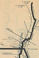
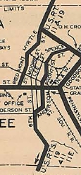
US 11 used State St east into central Bristol, then Front St north to Spencer St northeast to Mary St east to Goodson St north to Danville Ave east to Fairview St north to Massachussetts Av east to Texas Av north which becomes Old Abingdon Hwy. which runs back into US 11-19 near the I-81 interchange.
Bristol through Wytheville:
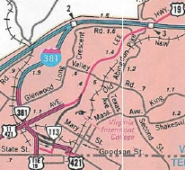
US 11 followed its modern routing approaching Abingdon, then used Colonial Ave and crossed the railroad to modern US 11 at roughly the Bytt St location. In eastern Washington County US 11 followed its modern route except for the SR 754 loop. US 11 used its current alignment to Chillhowie where it followed Main St (no longer connects back to Lee Hwy), except I-81 has broken up the actual US 11 alignment (for example, the stranded 4-lane alignment south of I-81 in this area). US 11 followed its current path to Marion (except used SR 642 through Seven Mile Ford) and appears to follow today's US 11 all the way to Wytheville. US 11 entered Wytheville on Grove Ave, then on Main St. East of Downtown, US 11 used S. 11th St and E. Withers Rd.
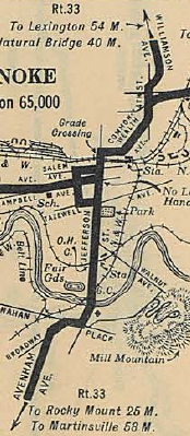
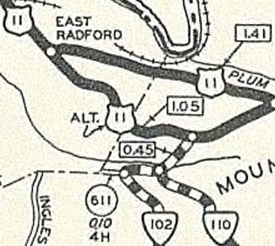
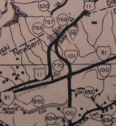
Wytheville through Roanoke:
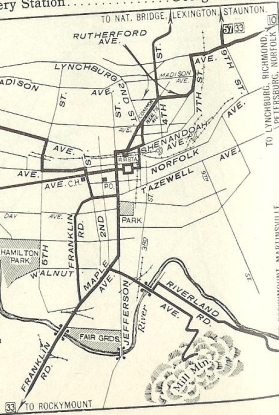
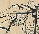
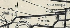
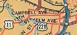
The 1975 Official is the first to show the one-way split get bigger - SB using 13th St to get from Salem Ave to Campbell instead of 2nd St.
About 1997, US 11 was removed from the SR 603 stubs in Elliston that had been the one-way northbound alignment that veered away from the southbound alignment. Roanoke to West Virginia:
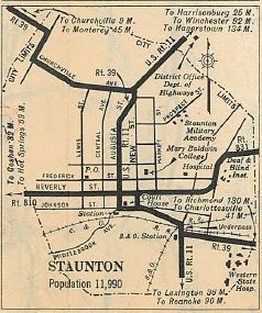
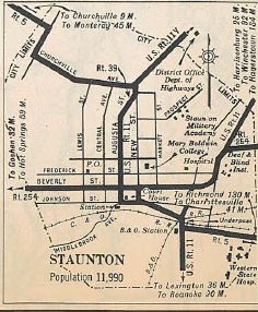
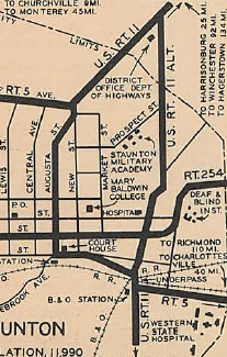
In March 1934 (CTB), US 11 was rerouted in Staunton to use Coalter St straight through. The old route through Downtown Staunton remained part of VA 5 and a newly designated US 11Y (now all part of US 11 Business). See scan under US 11Y entry. Note that the portion of this route within the City Limits of Staunton was placed into the state route system in July 1932 (CTB) with no apparent number. The 1932 Augusta County map showed Coalter St outside Staunton as not connecting directly to US 11. Also in March 1934 (CTB), US 11 was removed from Tollhouse Rd in Mauertown. In Sept 1934 (CTB), US 11 was rebuilt over some SR 717 and on new alignment north of Lexington, leaving behind VA 501, SR 750, and US 11 ALT (today these are SRs 631/681/750/645).
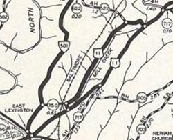
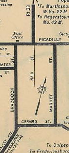
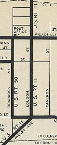
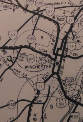
In Dec 1934 (CTB), US 11 was removed from SR 816 Burketown. About 1934, US 11 was removed from SR 1205 Main St in Greenville. Also in 1934, US 11 was rerouted in Winchester to use Valley and Loudoun. Braddock continued to be part of US 50 after that. In Oct 1935 (CTB), US 11 was returned to Downtown Staunton, replacing US 11Y, Coalter St became US 11 ALT (now a little VA 254 plus unnumbered routing). In Feb 1937 (CTB), US 11 was assigned to a bypass around the east of Buchanan for the purpose of building a new James River Bridge. It was to begin 0.2 miles north of the then-NCL of town and meet up with US 11 south of Buchanan. In Sept 1937 (CTB), US 11's bypass for Buchanan was rescinded and the new James River Bridge was placed where it is now. About 1938, US 11 was built on new alignment south of Lexington, leaving behind SR 764 and an extended VA 251 (now also unnumbered Thornhill Rd). In Feb 1939 (CTB), US 11 was removed from the SR 721 loop in Troutville. In April 1944 (CTB), US 11 was rerouted in Winchester off Valley-Loudoun and placed instead onto Braddock and North to Loudoun. The Valley-Loudoun route became US 11 ALT. See scan under US 11 ALT entries. In Aug 1950 (CTB), US 11 was given its current one-way splits through Winchester. NB US 11 on Cameron St had not been primary routing up to this point. The short diagonal piece on Valley Ave was a replacement of part of US 11 ALT.
On 6/2/50 (per July 1950 Virginia Hwy Bulletin), the US 11 Bypass of Staunton opened (early 50s maps imply it ran more around VA 261 but this is a drawing error). Official maps up through 1979 also show Coalter St as US Route and also US 11 Business route. However, the 1958 Augusta County map shows Coalter St as decommissioned. So I believe in 1950, US 11 was moved to its current bypass of Staunton. The old route through downtown Staunton became US 11 ALT (now US 11 Bus). March 1956 CTB also refers to Coalter St as SR 900.
I can't find a CTB reference to designate US 11 splitting into one-way splits in Harrisonburg, there is a reference to US 11 on Liberty St in the July 1956 CTB. In Jul 1961 (CTB), US 11 was placed onto I-81 between Exit 167 and just south of the SR 610 overpass leaving behind F-054 south of SR 608 and F-055 north of SR 608. In May 1966 (CTB), US 11 was placed onto I-81 between just south of the SR 610 overpass to Exit 175. South of today's Peaks View Ln was abandoned and not covered by I-81 pavement (SR 610 overpass required Lee Hwy to be rebuilt a little south in order to connect), but the rest became F-055. About 1976, US 11 was assigned to the bypass of Lexington, which had been US 11 ALT for many years. The old route through Lexington became US 11 Business. In 2021, US 11 southbound was rerouted at buchanan to leave I-81 at Exit 167 SR 614 Arcadia then follows F-054 back to where the now-removed Exit 168 ramp was. This had been part of US 11 before I-81 existed. Northbound US 11's routing is unchanged as the on-ramp to I-81 north at Exit 168 remains. Improvements: Upon designation in 1926, US 11 was fully paved The First segment of US 11 to be multilaned was from Botetourt SR 604 north to just short of Buchanan, by 1941. By 1947, US 11 was multilaned from US 460 Roanoke to today's VA 101. In 1949, US 11 was multilaned from Elliston to Glenvar; Fairfield to Steeles Tavern In 1950, US 11 was multilaned through downtown Winchester. In 1952, US 11 was multilaned from Christiansburg east a couple miles; Steeles Tavern to SR 620. In 1953, US 11 was multilaned from VA 91 north a couple miles; Pulaski north a couple miles; VA 114 through Radford; bottom of Christiansburg Mtn to Elliston; Fairfield south a couple miles; through Stephens City. In 1954, US 11 was multilaned from north of Pulaski to VA 100; SR 787 to VA 114; current VA 39 location to Fairfield In 1955, US 11 was multilaned from Wytheville south a couple miles; Maury River to current VA 39. In 1956, a 4 mile segment halfway between Chilhowie and Marion was multilaned. In 1958, US 11 was multilaned from Wytheville north a couple miles; erroneously shown as widened from Dublin to SR 787; Mt Crawford north a couple miles In 1960 or 1961, US 11 was multilaned from Wytheville to Carters Wayside; Strasburg area In 1962, US 11 was multilaned from VA 117 to SR 605 In 1964, some multilaning was removed between Chilhowie and Marion as I-81 was built here; US 11 was multialned when added to I-81 from Ft. Chiswell to VA 100. In 1965, US 11 was multilaned when added to I-81 from Buchanan to near Natural Bridge By 1969, US 11 was multilaned from VA 112 to US 11-460 ALT In 1975, US 11 was multilaned from VA 101 to SR 623. In 1976, US 11 was widened from VA 140 north to US 19 split. In Jan 2015, US 11 was 4-laned between Glenvar and VA 112. VDOT official maps are pretty inconsistent about some parts of US 11 and its multilaning. A fair amount of US 11 that is not 4-laned is/was 3-laned (a lot is now left center turn lane configuration today). Posted: Fully posted; A VA 11 shield exists in Marion Cutouts were prevalent in Christiansburg, Staunton, and Winchester up until about 2010 but as of 2022 none remain in these cities. A couple may remain in Harrisonburg and there are still some widely sprinkled from I-81 Exit 175 north to West Virginia. Outside of Christiansburg and a couple in Marion I am not aware of any south of Exit 175. Currently, the US 11 SB turn off Williamson onto Campbell in downtown Roanoke has not been signed for a number of years. Same goes for the US 11 NB turn off Main to College St in downtown Salem A vintage white border shield existed in Christiansburg SB at VA 8 until between 2012-15. White border shields in Roanoke are 1990 or newer. Multiplexes: US 19 (13.41 mi) US 58 ALT (0.24 mi) US 58 (0.30 mi) VA 16 (1.19 mi) US 21 (0.31 mi) I-77, I-81, US 52 (5.75 mi) I-77, I-81 (2.28 mi) I-81 I (8.42 mi) US 460 Bus (3.22 mi) US 460 (23.05 mi) US 220 Bus, US 221, VA 116 (0.30 mi) US 221, VA 116 (0.50 mi) VA 43 (0.18 mi) I-81 II (8.05 mi) US 250 (0.07 mi) VA 254 (0.68 mi) US 211 (0.27 mi) VA 55 (0.23 mi) US 50, US 522 (0.53 mi) US 522 (1.00 mi) Legislative names: Lee Highway, Bristol to New Market except Staunton/Lexington Bypasses (3-20-22 designation predates US 11); Lee-Jackson Highway, Natural Bridge to Lexington (10-25-23 designation predates US 11); Lee-Jackson Memorial Highway, New Market to Winchester (3-20-22 designation predates US 11); Maury Highway, Lexington to VA 39 (5-24-23 designation predates US 11); 116th infantry Regiment Highway, Roanoke to Winchester (since 3-2-97); Woodrow Wilson Pkwy, from US 11 Bus north to VA 262 (since 2-28-66) Gen. John H. Morgan Memorial Bridge over RR in Abingdon (2-7-40); Pioneer Memorial Bridge over Middle Fork Holston River (8-14-51); Shugart Memorial Bridge over Holston River (2-13-42); Southwest Virginia Memorial Bridge over New River (8-23-49); J. Sinclair Brown Memorial Bridge over RR in Salem (3-6-48); William Peace Hunter Bridge over RR in Roanoke (8-9-56); Veterans Memorial Bridge over Maury River (2-15-2001) Other names: Euclid Ave (Bristol); Main St (Abingdon); Main St (Marion); 12th St/Main St (Wytheville); Washington Ave/5th St (Pulaski); Broad St (Dublin); Norwood St/Main St (Radford); Radford Rd (Radford to Christiansburg); Radford St/Main St/Roanoke St (Christiansburg); Roanoke Rd (Christiansburg to Roanoke Co); Main St/College Ave/Colorado St/Apperson Dr (Salem); Brandon Ave/Grandin Rd/Memorial Ave/Campbell Ave/Williamson Rd (Roanoke); Main St (Buchanan); Greenville Ave/Commerce Rd (Staunton); Main St (Harrisonburg); VAlley Pike (Harrisonburg to New Market); Congress St (New Market); Old Valley Pike (Shenandoah/Warren Counties); Main St (Mt. Jackson); Main St (Edinburg); Main St (Woodstock); Main St (Toms Brook); Stover Ave/King St/Massanutten St (Strasburg); Valley Pike (Frederick Co s of Winchester); Main St (Middletown); Main St (Stephens City); Valley Ave/Gerrard St/Cameron St/Braddock St (Winchester); Martinsburg Pike (Frederick Co n of Winchester) Scenic Byway: VA 130 to SCL Lexington (12-18-97) Comments: US 11 is never far from I-81 anywhere it runs in Virginia. However, it often runs out of sight of the interstate and is in many places a lovely mountain valley drive. US 11 is pretty busy in the multiple cities it traverses, however. | |||||||||||||||||||||||||||||||