< VA 39 | Home | VA 41 >
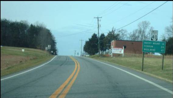
Photo: WB VA 40 in eastern Franklin County (photo by Mapmikey 1/16/10)
|
|
|
| ROUTE LOG |
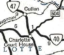
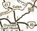
VA 8: 0 - 0 Franklin-Patrick Line: 9.85 - 9.85 US 220 Bus NB: 22.53 - 32.38 US 220 Bus SB: 0.03 - 32.41 US 220: 1.22 - 33.63 VA 122: 0.85 - 34.48 Pittsylvania-Franklin Line: 15.73 - 50.21 US 29: 13.53 - 63.74 US 29 Bus: 1.12 - 64.86 Halifax-Pittsylvania Line: 15.12 - 79.98 US 501 SB: 10.12 - 90.10 Campbell-Halifax Line: 0.97 - 91.07 US 501 NB: 0.85 - 91.92 Charlotte-Campbell Line: 4.99 - 96.91 VA 47 SB: 14.47 - 101.38 VA 47 NB: 0.10 - 101.48 VA 59: 8.72 - 110.20 US 15 Bus NB, US 360 Bus EB: 0.34 - 110.54 US 15 Bus SB, US 360 Bus WB: 0.56 - 111.10 US 15, US 360: 0.40 - 111.50 VA 385: 0.60 - 112.10 Lunenburg-Charlotte Line: 0.25 - 112.35 VA 49 SB: 12.70 - 125.05 VA 49 NB: 3.39 - 128.44 VA 137, VA 138: 6.79 - 135.23 Nottoway-Lunenburg Line: 4.66 - 139.89 VA 46: 4.98 - 144.87 US 460 Bus WB: 1.25 - 146.12 US 460 Bus EB: 0.59 - 146.71 Dinwiddie-Nottoway Line: 6.29 - 153.00 US 1: 14.42 - 167.42 I-85 (exit 42): 0.57 - 167.99 Sussex-Dinwiddie Line: 12.94 - 180.93 VA 40 Bus: 4.37 - 185.30 US 301, VA 40 Bus: 1.04 - 186.34 I-95 (exit 31): 0.08 - 186.42 VA 35: 13.25 - 199.67 US 460: 7.90 - 207.57 Surry-Sussex Line: 3.11 - 210.68 VA 10: 9.01 - 219.69
|
Creation: Appeared July 1933 as a renumbering of VA 20 from VA 8 Woolwine to US 15-360 Keysville. This is the 3rd VA 40.
|
Current VA 40 appears, from Woolwine to Keysville 1933 Official Adjustments: In Oct 1934, VA 40 was extended east with US 15-360 through Keysville, then replaced VA 48 east to Claremont.
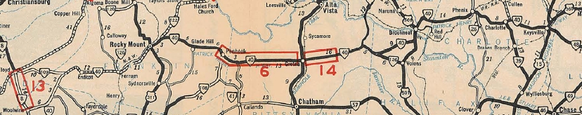
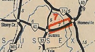
VA 40 extended from Keysville to Claremont Oct 1934 Official The 1936 Dinwiddie County map shows VA 40 following SR 609/616/617/619 through Cherry Hill and Bolsters Store to Sussex Co, but the 1936 Sussex County map shows VA 40 following current 40 west of Stony Creek. In Aug 1936 (CTB), VA 40 was placed on new routing east of Stony Creek, leaving behind a duplex with US 301 and SR 636 (now SR 659 and abandoned routing across the Nottoway River). Then another newly constructed segment bypassed Sussex CH to VA 35, leaving behind SR 634.
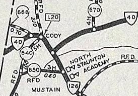
Sometime after 1936, VA 40 was removed from Main St in Brookneal. In Feb 1937 (CTB), VA 40 was rebuilt in the Cody area, leaving behind SR 668 and abandoned routing.
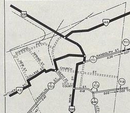
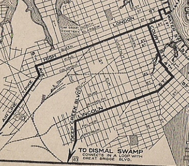
In Sept 1938 (CTB), VA 40 swapped routes with SR 753 in Rocky Mount. The old route used Hatcher St/Dent St/College St/Franklin St/High St. Now VA 40 used Franklin St all the way to today's US 220 Business as it does now.
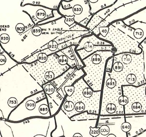
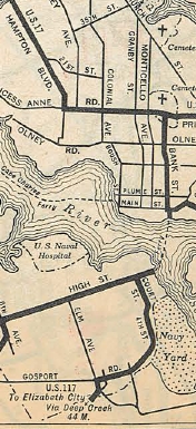
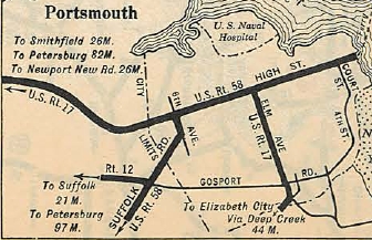
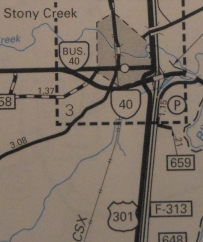
In April 1951 (CTB), VA 40 east was truncated to VA 10 Spring Grove, leaving behind SR 646. In Sept 1957 (CTB), VA 40 was removed from T1012 in Phenix. Also about 1957, VA 40 was removed from Old Court St in Victoria. In April 1958 (CTB), VA 40 was removed from SR 775 Neblett Field Rd south of Victoria. In March 1966 (CTB), VA 40 was rebuilt from Keysville west 5 miles, leaving behind some abandoned segments. In July 1966 (CTB), VA 40 was given its nominal bypass of Ferrum leaving behind SR 915, a bit of SR 623, and SR 805 Fieldcrest Rd. In Feb 1973 (CTB), VA 40 was removed from SR 614 Sunnyside Rd west out of McKenney. In April 1974 (CTB), VA 40 was removed from SR 606 Beaver Dam Rd east of Waverly. In May 1981 (CTB), VA 40 was removed from a bit of SR 736 west of Kenbridge. Also around 1981, VA 40 was given a bypass of Stony Creek as part of its intersection with the newly arriving I-95, leaving behind VA 40 Business and F317. Improvements: Upon designation VA 40 was paved from Rocky Mount to Keysville In 1934, VA 40 was paved on its eastern extension from Keysville to McKenney and from Stony Creek to Claremont. In 1936, VA 40 was paved from Ferrum to Rocky Mount; Stony Creek west to the Dinwiddie Line. In 1938, VA 40 was paved from McKenney to the Sussex Line. Between 1942-44, VA 40 was paved from Ferrum west to SR 605. VA 40 became fully paved in 1949 when the unpaved portion from Woolwine to SR 605 was paved. VA 40 is multilane only from US 220 to VA 122. Official maps say this happened in 2002 but it might be older than that. Posted: Fully posted; last cutout I was aware of was in Blackstone, removed sometime after 1992. Multiplexes: US 220 Bus (0.03 mi) US 501 (1.82 mi) VA 47 (0.10 mi) US 15 Bus, US 360 Bus (0.56 mi) VA 49 (3.39 mi) US 460 Bus (0.59 mi) Truck Route: There is a signed VA 40 TRUCK in Victoria using Railroad Ave and Tidewater Ave. The point is to avoid a tight turn onto VA 40-49 Court St. Legislative names: W. Hank Norton Highway, Patrick/Franklin line to Rocky Mount (since 3-28-94); Patrick Henry Highway, Brookneal to Keysville (2-18-28 designation predates VA 40) Sheriff W. Shively Memorial Bridge over RR in Ferrum (4-25-68); Stanhope Hurt Bridge over Pigg River (3-27-40); Millard B. Rice Jr Memorial Bridge over Cub Creek in Phenix (12-17-98) Other names: Charity Hwy (Patrick Co); Franklin St (Franklin Co); Main St/Pell Ave (Rocky Mount); Gretna Rd (Pittsylvania Co); Valden Dr (Gretna); Stage Coach Rd (Halifax Co); Lusardi Dr (Brookneal); Wickliffe Ave (Campbell Co); Main St (Phenix); David Bruce Ave (Charlotte CH); George Washingtn Hwy (Charlotte Co e of VA 47); Church St/McDonald Rd (Keysville); Lunenburg Hwy Charlotte Co e of US 15-360 Bus); Lunenburg County Rd (Lunenburg Co w of VA 49); Courthouse Rd (VA 49 dup); Court St/Main St (Victoria); K-V Rd (Victoria to Kenbridge); Main St/Broad St (Kenbridge); Kenbridge Rd (Nottoway Co e of Kenbridge); Main St/Dinwiddie Ave (Blackstone); Darvills Rd Blackstone to SR 644); Old Cryors Rd (SR 644 to SR 610); McKenney Hwy (Dinwiddie Co e of SR 610); Doyle Blvd (McKenney); Sussex Dr (Sussex Co); Main St (Waverly); Martin Luther King Hwy (Surry Co) Scenic Byway: Campbell SR 600 to Charlotte CH (sometime after 2003). Comment: VA 40 is currently the longest state route in Virginia. VA 40 west of Ferrum is not recommended for trucks. Although there is not much elevation change on its way over to Woolwine, there are numerous sharp curves and few straight stretches. There are a few wooden bridges used by VA 40 out this way though they do have a layer of pavement over them. The 1939 VDOT report on primary system development had recommended that VA 40 be decommissioned from VA 8 to then-VA 109 and also from Waverly to Spring Grove. | Previous VA 40's:
1932 ROUTE LOG US 17 NB, US 58, VA 10: 0 - 0 VA 504: 7 - 7 VA 543: 9 - 16 NC STATE LINE: 4 - 20 |
VA 40 #2: The 1933 draft route log had VA 40 running from US 221 Burkeville (really) southwest to Danville via Keysville and Halifax, then southeast into NC. This would've replaced US 501 Burkeville to Halifax; VA 12 Halifax to Danville; VA 301 Danville to NC. This was part of Virginia's wish to eliminate US 501 in Virginia. Instead, what happened in July 1933 was Burkeville to Danville became US 360 (though VDOH actually requested US 33) and Danville to NC became VA 86.
 VA 40 running Burkeville to Danville and NC 1933 draft route log | |||||||||||||||||||||

Page last modified 26 March 2022