< US 441 | Home | US 501 >
US 460 | US 460 Business | US 460-Y
US 60 | US 360
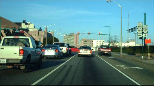
Photo: A rare US 460 ALT shield in Norfolk (photo by Mapmikey 3/6/10)
| |||||||
| ROUTE LOG US 11, US 11 ALT BEGIN, US 460: 0 - 0 US 11: 1.11 - 1.11 VA 419 SB: 1.39 - 2.50 US 11 ALT NB, US 460, VA 419 NB: 0.53 - 3.03 |
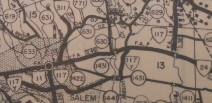
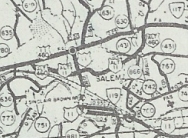
Creation: Designated in 1947, running generally as it does today as a renumbering of VA 117-Y. This is the 1st of 5 US 460 ALTs
Adjustments: By 1958, US 460 ALT was removed from Lynchburg Turnpike and Schrader St in the MAson Creek area. Improvements: Paved upon inception; brief multilaning near its western end. Posted: Fully posted Multiplexes: US 11 ALT (2.50 mi) US 11 ALT, VA 419 (0.53 mi) Legislative names: None Other names: 4th St/Texas St/Electric Rd (Salem) Scenic Byway: no segments Comment: US 460 ALT exists to give trucks a routing away from central Salem. It has speed limits no different than mainline US 460. Doesn't show up on VDOT Officials until 1961 but is shown in the '58 County Atlas.
| ||||||
| ||||||
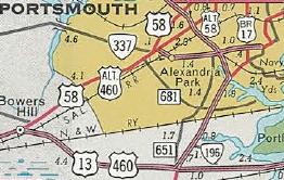
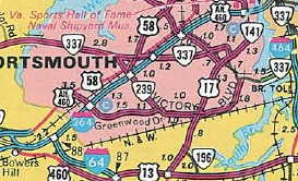
| ROUTE LOG I-664 (exit 13), US 13, US 58 WB, US 460, VA 191: 0 - 0 Portsmouth-Chesapeake Line: 1.72 - 1.72 VA 239: 1.79 - 3.51 US 58 EB, VA 337 WB: 0.28 - 3.79 VA 337 ALT: 0.10 - 3.89 I-264 WB (exit 4), VA 337 EB: 0.15 - 4.04 US 17: 0.94 - 4.98 VA 141: 1.66 - 6.64 Norfolk-Portsmouth Line: 0.87 - 7.51 I-464 (exit 6), VA 337 WB: 0.55 - 8.06 I-264 EB (exit 9), VA 337 EB, VA 337 ALT: 0.41 - 8.47 US 460, VA 337: 0.83 - 9.30 |
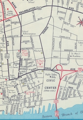
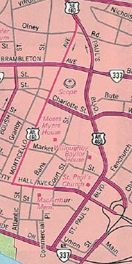
Creation: US 460 ALT appeared November 1952 (CTB Minutes). It
ran from US 13-58-460 Bowers Hill along US 58 to Portsmouth, then east
along Portsmouth Blvd to Norfolk Naval Shipyard, then north along 7th
St/Washington Ave. It turned east at today's I-264 to use the Downtown
Tunnel and the Berkley Bridge. In Norfolk, there was a simple trumpet
interchange at City Hall Ave. US 460 ALT cut west on City Hall, then
used one-way splits of Bank St (EB) and Monticello Ave (WB), ending at
US 460 Brambleton Ave. This is the 2nd of 5 US 460 ALTs
Adjustments: Sometime after 1963, US 460 ALT EB in downtown Norfolk was removed from Bank St and put on St. Paul's Blvd. My guess is that it was moved as part of building the Norfolk Scope which opened in 1971.
US 460 ALT was moved onto I-264 from Portsmouth Blvd. through Portsmouth in March 1968 (CTB). Portsmouth Blvd remained part of VA 337 while the remainder is city streets.
US 460 ALT was not explicitly labeled on Officials until 1955. Improvements: Paved upon inception; Multilane on its VA 337 and I-264 multiplexes, plus Downtown Norfolk. Posted: Fully posted from Bowers Hill to I-264. The last shield EB directs you onto I-264. In 1993 there was 1 shield on Monticello Ave at City Hall Ave but appears to be gone now. By February 2013, a new shield was installed on Brambleton Ave at St. Paul's Blvd. Multiplexes: US 58 (3.79 mi) VA 337 (0.25 mi) I-264 (4.02 mi) I-264, VA 337 (0.41 mi) Legislative names: A.L. Philpott Memorial Highway, US 58 duplex (since 3/3/92) Other names: Airline Blvd (US 58 duplex); Portsmouth Blvd (VA 337 duplex); St. Pauls Blvd/Monticello Ave/City Hall Ave (Norfolk) Scenic Byway: no segments Comment: US 460 ALT is much more direct (4.15 miles shorter) from Bowers Hill to Norfolk than mainline US 460. | |||||
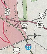
| Previous US 460 ALT's:
1989 ROUTE LOG I-95: 0 - 0 US 460: 0.30 - 0.30 1964 ROUTE LOG US 460, VA 83: 0 - 0 US 460, VA 83: 0.55 - 0.55 |
|
|||||
Previous: US 441 |
Next: US 501
US 460 | US 460 Bus | US 460-Y
US 60 | US 360
Top | Virginia Hwy Index
Home
Page last modified 17 March 2022