< VA 180 | Home | VA 201 to 220 >
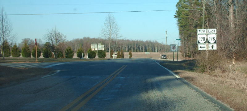
Photo: Old VA 198 (SR 601) arrives at current VA 198 (photo by Mapmikey 2/16/07)
| VA 181
to 200 < VA 180 | Home | VA 201 to 220 > |
Photo: Old VA 198 (SR 601) arrives at current VA 198 (photo by Mapmikey 2/16/07) |
| |||||
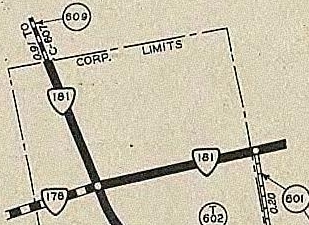
| ROUTE LOG SR 609: 0 - 0 VA 178: 0.20 - 0.20 US 13: 0.70 - 0.90 |
Creation: Appeared in July 1933 as a renumbering of VA 526 running as it does today. This is the 2nd VA 181.
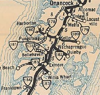
Adjustments: None Improvements: Paved upon inception; no multilane segments Posted: Fully posted Multiplexes: NONE Legislative names: NONE Other names: King St Scenic Byway: NONE Comment: VA 181 connects US 13 to Belle Haven. The E-W portion of VA 181 was once part of US 13. | ||||
| Previous VA 181's:
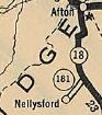
1928 ROUTE LOG VA 18: 0 - 0 END VA 181 EB: 2 - 2 |
VA 181 #1: Appeared in March 1924 as new routing, running from VA 18 (now VA 6) southwest 2 miles to Nellysford.
In August 1928, VA 181 was renumbered as VA 315. Today it is VA 151 which has since been rebuilt. Parts of SR 612 and SR 613 use the original VA 181 alignment.
|
||||
| |||||
| ROUTE LOG US 13: 0 - 0 SR 605: 3.71 - 3.71 |
Creation: Appeared in July 1933 as a renumbering of VA 530. Ran as it does today. This is the 2nd VA 182.
Adjustments: It is possible VA 182 used SR 1203 in Painter instead of the its current route but stopped doing so by 1936 if it ever did. Improvements: Paved upon inception; no multilane segments Posted: Fully posted; a cutout at SR 600 SB Mappsburg was still there in 2008 but was gone by 2012. Multiplexes: None Legislative names: None Other names: Mappsburg Rd (Painter); Quinby Bridge Rd (outside Painter) Scenic Byway: None Comment: VA 182 is just another unassuming route on the Eastern Shore. |
1933 Official |
|||
| Previous VA 182's:
1928 ROUTE LOG VA 18: 0 - 0 END VA 182: 1.75 - 1.75 |
VA 182 #1: Appeared in March 1927 (CTB) as new primary routing,
running from VA 18 (now VA 151) near Piney River west 1.75 miles
towards Lowesville.
In August 1928, VA 182 was renumbered as VA 313. Today it is SR 778. VA 182 #1 does not appear on any maps I have found. |
||||
| |||||
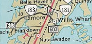
| ROUTE LOG SR 613: 0 - 0 US 13: 6.94 - 6.94 US 13 Bus: 0.51 - 7.45 |
Creation: Appeared in July 1933 as a renumbering of VA 537.
This is the only VA 183. Ran from Willis Wharf (just east of today's SR
694) west through Exmore toward Silver Beach for a distance of about 5
miles. See scan in VA 182 entry. Adjustments: In Aug 1933 (CTB), VA 183 was extended west 1.5 miles. In Sept 1934 (CTB), VA 183 was extended west 2.14 more miles towards Silver Beach. In May 1963 (CTB), VA 183 east was truncated to US 13 Bus Exmore, leaving behind SR 603. Improvements: Paved at time of inception except a short stretch just west of Exmore, which was paved in 1935. No multilane segments. Posted: Fully posted Multiplexes: None Legislative names: None Other names: Occohannock Neck Rd. Scenic Byway: No segments Comment: VA 183 continues as SR 613 to Silver Beach. |
1965 Official |
|||
| |||||
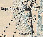
| ROUTE LOG US 13, US 13 Bus: 0 - 0 SR T1101, SR T1106: 3.20 - 3.20 |
Creation: Appeared in May 1957 (CTB) as a renumbering of US 13 ALT, running the way it does now. This is the 2nd VA 184.
Adjustments: None Improvements: Paved upon inception; no multilane segments. Posting: Fully posted east of Cape Charles; poorly posted in Cape Charles last time I was there in 2008. Multiplexes: None Legislative names: None Other names: Bay Av/Mason Av/Stone Rd Scenic Byway: No segments Comment: This was the original route of US 13 approaching the ferry across Chesapeake Bay. |

1959 Official |
|||
| Previous VA 184's:
1940 ROUTE LOG US 13: 0 - 0 SR 609/618: 1.6 - 1.6 |
VA 184 #1: Appeared in July 1933 as a renumbering of VA 527. Ran from US 13 Nassawaddox to Franktown in an 'L' shape.
In March 1953 (CTB), VA 184 downgraded to SRs 606 and 618. |
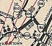
1936 Northampton County |
|||
| |||||
| ROUTE LOG SR 675/686: 0 - 0 I-81 (Exit 279): 0.08 - 0.08 US 11: 0.92 - 1.00 |
Creation: Appeared in March 1964 (CTB) as an upgrade to SR 675, running as it does now. This is the 2nd VA 185.
Adjustments: None Improvements: Fully paved upon inception; no multilane segments Posted: Fully posted; last known cutout removed from US 11 NB in mid-2000s. Fully posted as a duplex with SR 675. Multiplexes: None Legislative names: None Other names: Stoney Creek Blvd. Scenic Byway: None Comment: Another short primary connector from I-81 to US 11. Both the 2003 route log and the 2007 traffic logs explicitly put VA 185's west end beyond I-81. |
1965 Official |
|||
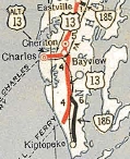
| Previous VA 185's:
1951 ROUTE LOG US 13: 0 - 0 SR 631: 0.88 - 0.88 |
VA 185 #1: Appeared July 1933 as a renumbering of VA 524 running from US 13 (now Bus 13) Eastville east to the railroad tracks at Eastville Station.
In March 1952 (CTB), VA 185 was downgraded to SR 631. |

1933 Official |
|||
| |||||
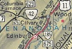
| ROUTE LOG VA 35: 0 - 0 NC STATE LINE: 6.21 - 6.21 |
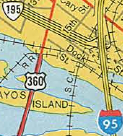
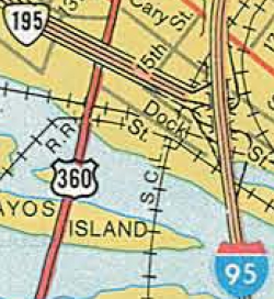
Creation: VA 186 was created Aug 1973 (CTB) as a renumbering of VA 195, running the way it does now. This is the 2nd VA 186.
Adjustments: None
Improvements: Paved upon inception; no multilane segments Posted: Fully posted Multiplexes: None Legislative names: NONE Other names: Pittman Rd (Branchville to Boykins) Scenic Byway: No segments Comment: VA 186 can be used as an effective short-cut from I-95 to US 58, via VA 35 and SR 671 to Franklin. In fact, SR 671 is a good candidate to receive an extension of VA 186... |
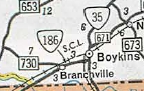
1974 Official |
|||
| Previous VA 186's:
1951 ROUTE LOG US 13: 0 - 0 END VA 186: 5 - 5 |
VA 186 #1: Appeared in July 1933 as a renumbering of VA 525.
It began at US 13 (now 13 Bus) Cheriton and headed south to Kiptopeke.
Its southern endpoint was where current SR 600 met the now-removed
railroad, which is literally just to the east of the US 13/SR 600 jct.
Sometime in 1950 (per April 1951 CTB), US 13 was rerouted from Cape Charles to the Kiptopeke Ferry location. Some of this rerouting was directly on VA 186. So VA 186 was truncated to the US 13/SR 683 location near Capeville, leaving behind SR 641, SR 684 and US 13. The next year, it looks like the rest of VA 186 was downgraded to SR 600 and SR 683.
|
||||
| |||||
| ROUTE LOG SR 658: 0 - 0 VA 316: 1.51 - 1.51 US 13: 2.19 - 3.70 SR 679 NB: 1.73 - 5.43 |
Creation: VA 187 was created in July 1933 as a renumbering of VA 531, running the way it does today. This is the only VA 187.
Adjustments: None Improvements: Paved upon inception; no multilane segments Posted: Fully posted at US 13 and VA 316; Only posted with a white rectangle at SR 658 and not at all at its eastern endpoint, though it is posted well along its SR 679 duplex. Multiplexes: None Legislative names: NONE Other names: Shoremain Dr (Bloxom); Nelsonia Rd (east of US 13) Scenic Byway: No segments Comment: VA 187 is easily the least improved primary route on the Eastern Shore, with secondary characteristics in most locations. The 1939 VDOT report on primary system development had recommended that VA 187 be decommissioned east of US 13. |
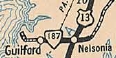
1933 Official |
|||
| |||||
| ROUTE LOG US 60 Bus, US 220 Bus: 0 - 0 SR 606: 1 - 1 |
Creation: Number assigned between 1944-49 running essentially as it does
today. I cannot find a CTB reference for this but it appears in the
1949 VDOT Route Log. Note that this corridor was assigned as a primary route with no number in July 1932 CTB. This is the 2nd VA 188.
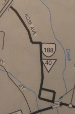
Adjustments: Sometime after 1975, VA 188 was placed on one-way alignments at its southern end. This was likely to accomodate US 60-220 being placed on one-way alignments of their own. The original VA 188 alignment used the current NB routing. Improvements: Paved upon inception; no multilane segments Posted: Extremely well-posted on 188 itself; not posted at all from US 60 Bus WB or at its northern endpoint. All postings were cutouts at last check in 2008; Multiplexes: None Legislative names: None Other names: Main St, 1 block McCormick Blvd (NB VA 188); Church St/Commercial Ave (SB VA 188); McCormick Blvd/Lafayette St/Rose Ave/Tremont St/Sioux Ave (two-way VA 188) Scenic Byway: No segments Comment: VA 188's NB segments are west of the SB segments. VA 188 connects US 60-220 to SR 606 which is a prominent way to reach the Homestead, or so signs along VA 188 would have one believe. VA 188 didn't appear on VDOT Officials until 1994.
| ||||
| Previous VA 188's:
1942 ROUTE LOG US 60: 0 - 0 VA 168: 1.52 - 1.52 SR 606-607: 0.78 - 2.30 |
VA 188 #1: Appeared in July 1933 as a renumbering of VA 534, running from US 60 Norge east to SR 606/607 Croaker.
In April 1944 (CTB), VA 188 was downgraded to SR 607. Today, it is also Norge Ln and Maxton Ln at the railroad crossing. Oddly, VA 188 is shown as VA 100 on the 1936 James City County map. |

1933 Official |
|||
| ||||||
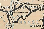
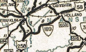
| ROUTE LOG US 258: 0 - 0 Suffolk-Southampton Line Line: 2.42 - 2.42 VA 272: 2.18 - 4.60 US 58 WB, US 258: 0.78 - 5.38 VA 272: 1.26 - 6.64 US 58 EB: 4.17 - 10.81 US 58 Bus: 0.49 - 11.30 |
Creation: Appeared July 1933 as a renumbering of VA 535.
Originally ran from US 158 (now US 258 Bus) Franklin south and then
east to loop around to end at US 58 Holland. This is the only VA 189.
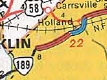
Adjustments: In March 1934 (CTB), the route was removed from today's SR 686 in Nanesmond County (at the eastern end of VA 272), as well part of today's SR 666/615 east of the Blackwater River. In Sept 1940 (CTB), VA 189 was extended north 0.04 miles to US 258. It appears when primary maintenance was dropped from all incorporated towns in 1929, they never reassigned the small portion of this route into the primary system until now. In May 1943 (CTB), VA 189 was rerouted at the Blackwater River to instead go to US 258 like it does today, replacing VA 315. The old route to Franklin became SR 714. In Nov 1975 (CTB), VA 189 was placed on a new bypass of Holland, leaving behind VA 189 Business. In 1983 or 1984, VA 189 was removed from the Holland bypass and re-sent back into Holland as it does today, replacing VA 189 Business. The Holland Bypass remained part of US 58. Around 1989, VA 189 was rerouted onto new construction to meet the US 58-VA 260 interchange east of Franklin. The old route became VA 272. Improvements: Paved in Nanesmond County upon inception The rest was paved in 1936. VA 189 was multilaned on what is now its US 58 duplex since Nov 1975. Posted: Fully posted; However, VA 189 is extremely poorly posted on its US 58 duplex. No mention at VA 272 or where the route splits to head to Holland. GMSV shows a shield at both old SR 612 and old SR 616. Multiplexes: US 58 (5.43 mi) Legislative names: A.L. Philpott Hwy (US 58 duplex) since 3-3-92 Other names: S. Quay Rd (west of VA 272); Franklin Bypass Scenic Byway: No segments Comment: VA 189 between SR 714 and VA 272 was still original concrete in late 2012, per field visit by Froggie. The VA 189 routing really makes no sense to me. VA 189 south of US 58 should be part of US 258. VA 189 could then just be reduced to the short stretch in Holland.
| |||||
| Previous VA 189's:
1980 ROUTE LOG VA 189: 0 - 0 US 58 WB: 0.49 - 0.49 US 58 EB, VA 189: 0.72 - 1.21 |
VA 189 Business: Appeared in November 1975 (CTB) as a
renumbering of VA 189 into Holland. It was also specifically defined to
continue east on US 58 back to the new VA 189 Bypass (now US 58
Bypass). This stretch had never been part of VA 189.
In 1983 or 1984, VA 189 Business reverted back to mainline VA 189. However, it appears in the 1985 VDOT Traffic Log (but not 1990). When I lived in Tidewater in 1991, this was still partially posted as Business 189. A field visit in Oct 2009 showed it still posted as 189 Business leaving 58 Business. | |||||
| |||||
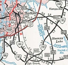
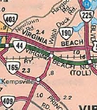
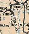
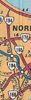
| ROUTE LOG VA 166: 0 - 0 I-64 (exit 292): 1.13 - 1.13 US 17: 0.26 - 1.39 VA 168 Bus: 2.34 - 3.73 Virginia Beach-Chesapeake Line: 3.59 - 7.32 VA 165: 4.79 - 12.11 I-264 (exit 16): 0.72 - 12.83 US 58: 0.60 - 13.43 VA 225: 2.00 - 15.43 |
Creation: Appeared in March 1956 (CTB) as a renumbering of part of VA 166. It initially ran from VA 166 to VA 165 Kempsville. This is the 2nd VA 190.
Adjustments: In July 1962 (CTB), Princess Anne County requested VA 190 be extended north to VA 166 (now Shell Rd) Robbins Corner. This request was denied. The June 1964 CTB had VA 190 east truncated to the Chesapeake-Virginia Beach line as part of the creation of VA 225. However, it didn't appear to have actually been truncated. In Aug 1980 (CTB), VA 190 was extended north to VA 225 as upgraded routing over what had once been SR 647.
Improvements: VA 190 was paved upon inception. VA 190 was multilaned from roughly Indian River Rd to VA 165 in 1972. When extended north it was multilaned to US 58. In 1983 or 1984, VA 190 was multilaned most of the way north of US 58 to VA 225. In 1988, VA 190 was multilaned from Indian River Rd south to Centerville Tpk. In 1990, the gap near VA 225 was multilaned. In 2002, VA 190 was multilaned from Centerville Tpk to Great Bridge Posted: Fully posted, although not well north of US 58; SR 190 shields in Virginia Beach were nearly universal. At least one, at VA 225 SB was still up in 2007 but was gone by February 2013. Unposted from US 58 for many years, but finally posted at US 58 by February 2013. Not posted from I-264. Multiplexes: none Legislative names: None Other names: Colony Rd Scenic Byway: No segments Comment: VA 190 is not one of those routes you'd probably drive from end-to-end on to get anywhere. The interchange with I-64 is a single off-ramp from the Norfolk-bound direction of I-64. The 1939 VDOT report on primary system development had recommended that VA 190 (then VA 166) be decommissioned from Great Bridge to VA 165 Kempsville. | ||||
| Previous VA 190's:
1952 ROUTE LOG VA 165: 0 - 0 Princess Anne-Norfolk Line: 2.70 - 2.70 SR 615: 7.02 - 9.72 |
|
||||
| |||||
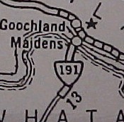
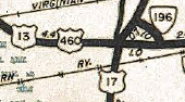
| ROUTE LOG US 13, US 460: 0 - 0 US 58, US 460 ALT: 0.18 - 0.18 VA 337: 3.13 - 3.13 |
Creation: Appeared in July 1933 as a renumbering of VA 539, running about the way it does now.
This is the 2nd VA 191.
Adjustments: About 1983, VA 191 was extended south underneath what is now the I-664 bridge. This had been a piece of US 58-460 ALT which was moved to its current location. About 1992, VA 191 was rerouted on its north end to accomodate the I-664/VA 337 interchange leaving behind Old Joliff Rd. Improvements: paved upon desgination; no multilane segments Posted: Fully posted except not south of US 58-460 ALT. This section is posted as US 13 NB and US 460 WB. Multiplexes: None Legislative names: None Other names: Joliff Rd Scenic Byway: No segments Comment: VA 191 is essentially a glorified frontage road to I-664 and serves no real primary purpose. Although there are VA 191 shields on BGSs on I-664 at its interchange with US 13-58-460, there are no direct ramps to VA 191 which crosses I-664 a little north of that interchange. The 1939 VDOT report on primary system development had recommended that VA 191 be decommissioned in its entirety. |

1933 Official |
|||
| Previous VA 191's:
1928 ROUTE LOG VA 19: 0 - 0 END VA 191: 4.4 - 4.4 |
VA 191 #1: Appeared March 1927 (CTB) as new primary routing, running from VA 19 (now VA 6) near Goochland CH south to Jefferson.
In August 1928, VA 191 was renumbered as VA 417. Today it is US 522 and also SR 669 south of the James River. In Maidens VA 191 used parts of SR 716 and 717. |
1928 Official |
|||
| |||||
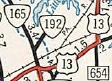
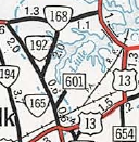
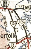
| ROUTE LOG VA 165: 0 - 0 VA 170: 2.02 - 2.02 |
Creation: Appeared in May 1952 (CTB) as an upgrade to SR 600, running as it does now. This is the 3rd VA 192.
Adjustments: None Improvements: Paved since inception VA 192 was multilaned from VA 165 to Norview Ave in 1980. Posted: Not posted. Shields previously existed at VA 165, but they were gone by early 2013. Shields had also existed at VA 170 in the early 1990s. Multiplexes: None Legislative names: None Other names: Azalea Garden Rd Scenic Byway: No segments Comment: Skirts the Norfolk International Airport and serves the Norfolk Botanical Gardens. | ||||
| Previous VA 192's:
1947 ROUTE LOG VA 10: 0 - 0 SR 628: 4.43 - 4.43 1952 ROUTE LOG VA 165: 0 - 0 Princess Anne-Norfolk Line: 0.39 - 0.39 END VA 192: 0.32 - 0.71 |
VA 192 #1: Appeared in July 1933 as a renumbering of VA 541. It ran from VA 10 Chuckatuck northeast toward Crittenden.
In Aug 1933 (CTB), VA 192 was extended east 0.83 miles (2.2 miles short of US 17). In June 1947 (CTB), VA 192 was downgraded to SR 628 (now Crittenden Rd in Suffolk) except the westernmost bit is part of VA 125. It currently comprises about half of the posted detour for VA 125 around the Nanesmond River. VA 192 #2: Appeared April 1951 (CTB) as an upgrade to SR 601, running 0.71 miles from VA 165 to Norfolk Municipal Airport. In May 1952 (CTB), VA 192 was downgraded back to SR 601. Today it is Robin Hood Rd. Part of the original concrete roadway still exists on this route.
|
||||
| |||||
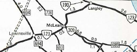
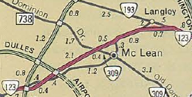
| ROUTE LOG VA 7: 0 - 0 I-495 (exit 44): 9.28 - 9.28 VA 123: 2.51 - 11.79 |
Creation: Created May 1948 (CTB Minutes) as an upgrade to
SR 604, running from VA 7 to VA 123 (now SR 3563 Old Chain Bridge Rd).
This is the 2nd VA 193.
Adjustments: In Nov 1963 (CTB), VA 193 was extended east to its current end, replacing a bit of VA 123.
Improvements: Paved upon inception; Multilane only right at its eastern end. Posting: Fully posted Multiplexes: None Legislative names: Betty Cooke Memorial Bridge over Scotts Run (6-17-99) Other names: Georgetown Pike Scenic Byway: Entire route, since 6-20-74; Comments: VA 193 is not recommended for trucks west of I-495 as there are several 20 mph curves. However, there is no posted VA 193 TRUCK...use VA 7 if you would. VA 193 follows the much older Georgetown Turnpike toll road. | ||||
| Previous VA 193's:
1944 ROUTE LOG US 17: 0 - 0 VA 170: 11.64 - 11.64 |
VA 193 #1: Appeared July 1933 as a renumbering of VA 543, running from US 17 Wallaceton east to VA 27 (now old VA 168) near the NC/VA line.
In May 1945 (CTB), VA 193 was downgraded to SR 740 and today is just Ballahack Rd. |
 Original VA 193. 1933 Official |
|||
| |||||
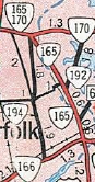
| ROUTE LOG VA 166: 0 - 0 VA 247: 1.63 - 1.63 I-64 (exit 278): 0.87 - 2.50 VA 165: 0.85 - 3.35 US 60: 2.40 - 5.75 |
Creation: Appeared in June 1947 (CTB) as an upgrade to SR
673, running on Sewells Point Rd from VA 13Y (now VA 166) to VA 165-168
Little Creek Rd.
This is the 2nd VA 194. Adjustments: In March 1953 (CTB), VA 194 was rerouted at Norview Ave to use Chesapeake Blvd (replaced SR 678). In Dec 1980 (CTB), VA 194 was extended north to US 60. However, as late as 1993 there was still an END 194 shield at VA 165 and no 194 postings north of there. VA 194 became posted to US 60 around 1999. Improvements: Paved upon inception The extension north of VA 165 was already multilaned at that time. Posting: Fully posted; error I-194 shield at VA 247 exists in 2009. Multiplexes: None Legislative names: None Other names: Sewells Point Rd and Chesapeake Blvd Scenic Byway: no segments Comment: A totally urbanized primary route.
| ||||
| Previous VA 194's:
1940 ROUTE LOG VA 35: 0 - 0 SR 673: 3.30 - 3.30 |
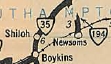
VA 194 #1: Appeared in July 1933 as a renumbering of VA 544, running from VA 35 to the railroad crossing in Newsoms.
In May 1946 (CTB), VA 194 was downgraded to SR 673. |
1933 Official |
|||
| I-195 |
| ||||||
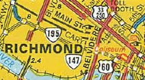
| ROUTE LOG I-195: 0 - 0 VA 146: 0.24 - 0.24 US 1, US 301: 1.5 - 1.74 US 60: 1 - 2.74 I-95 (exit 74): 0.65 - 3.39 |
Creation: Appeared as new designation for the Downtown Expressway in Jan 1976 (CTB) as a renumbering of what was VA 88
in the planning stages of the road. Initially was only open west of US
60 to its present transition to I-195 which is at the McCloy Street
overpass. This is the 2nd VA 195.
Adjustments: In 1977, VA 195 was extended east to connect with I-95 North.
In 1978, ramps to and from I-95 South were opened.
Improvements: Fully multilane expressway upon opening. Posting: Fully posted; An error US 195 shield existed about 2005-2008 along I-95 NB ramp to VA 195 Multiplexes: None Legislative names: None Other names: Downtown Expressway Scenic Byway: No segments Comment: VA 195 has been a toll road for its entire existence which connects I-195 and the Powhite Pkwy to I-95 through downtown Richmond. | |||||
| Previous VA 195's:
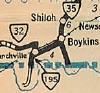
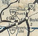
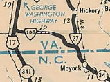
1974 ROUTE LOG VA 35: 0 - 0 NC STATE LINE: 6.21 - 6.21 |
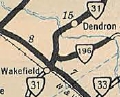
VA 195 #1: Appeared in July 1933 as a renumbering of VA 545, running from VA 32 (now SR 730) Branchville due south to the North Carolina Line.
In Sept 1934 (CTB), VA 195 was rerouted to run from Branchville southwest along the railroad tracks to reach North Carolina as new construction. This left behind SR 701. IN Sept 1940 (CTB), VA 195 was extended east to VA 35 Boykins, replacing a little bit of VA 32. In Aug 1973 (CTB), VA 195 was renumbered as VA 186.
|
|||||
| |||||
| ROUTE LOG US 17: 0 - 0 US 13, US 460: 0.96 - 0.96 |
Creation: Appeared in Sept 1942 as an upgrade to SR 649, running as it does today. This is the 2nd VA 196.
Adjustments: None Improvements: Paved upon designation; entire route is 4-lane undivided but I don't remember if it was this way in 1991 and Official maps still show it as 2-lane. Posting: Fully posted Multiplexes: NONE Legislative names: NONE Other names: Canal Dr. Scenic Byway: No segments Comment: VA 196 is strictly a residential route these days. |
1944 Official |
|||
| Previous VA 196's:
1941 ROUTE LOG VA 31: 0 - 0 Surry-Sussex Line: 0.81 - 0.81 SR 630: 5.18 - 5.99 |
VA 196 #1: Appeared in July 1933 as a renumbering of VA 546. Ran from VA 31 Wakefield east to just short of Walls Bridge over the Blackwater River.
In Sept 1942 (CTB), VA 196 was downgraded to SR 617. |
1933 Official |
|||
| |||||
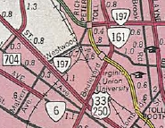
| ROUTE LOG VA 147: 0 - 0 VA 6: 0.60 - 0.60 US 33, US 250: 0.60 - 1.20 Henrico-Richmond Line: 0.02 - 1.22 Richmond-Henrico Line: 0.52 - 1.74 VA 161: 1.02 - 2.76 US 1, US 301: 0.84 - 3.60 |
Creation: Appeared in the January 1962 CTB defining the
route it uses today. However, per the July 1966 CTB, VA 197 was not
actually in place until July 1966. Ran as it does today. This is the 2nd VA 197.
Adjustments: None Improvements: Paved upon designation; 100% multilaned. Posting: fully posted; a couple cutouts remain; white border shields WB where it transitions from Laburnum to Malvern; erroneous VA 197 east shield leaving past US 1-301. Multiplexes: None Legislative names: NONE Other names: Malvern Ave, Westwood Ave, Saunders Ave, Laburnum Ave Scenic Byway: No segments Comment: VA 197 has a very brief one-way split leaving Laburnum. | ||||
| Previous VA 197's:
1960 ROUTE LOG VA 147: 0 - 0 VA 6: 1.70 - 1.70 |
VA 197 #1: Appeared in July 1933 as a renumbering of what I believe was part of a VA 19 and VA 418 duplex. Ran from VA 6 to VA 147 along Three Chopt Road.
In July 1966, VA 197 was downgraded to plain old Three Chopt Rd.
| ||||
| |||||
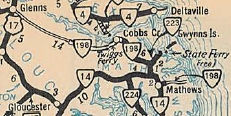
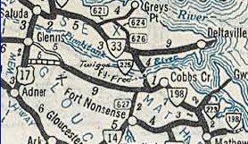
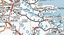
| ROUTE LOG US 17, VA 33: 0 - 0 Mathews-Gloucester Line: 11.47 - 11.47 VA 3 EB: 0.44 - 11.71 VA 3 WB: 1.55 - 13.26 VA 223: 6.24 - 19.50 VA 14 WB: 0.93 - 20.43 VA 14 EB: 1.69 - 22.12 SR 642, SR 653: 1.01 - 23.13 |
Creation: Appeared in July 1933 as a renumbering of all of VA 601 (west of Cobbs Creek), a piece of VA 38 (Cobbs Creek to Mathews) and a small piece of VA 600
(Mathews to Moon). Initially ran from Moon west through Mathews and
Cobbs Creek into Gloucester County. This is the only VA 198.
Adjustments: In Oct 1935 (CTB), VA 198 was extended west 6.51 miles to Cash. In Sept 1937 (CTB), VA 198 was extended west 1 mile. In May 1938 (CTB), VA 198 was extended to US 17 at Dutton. In Oct 1969 (CTB), VA 198 and SR 601 swapped routings, giving VA 198 its run to Glenns.
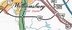
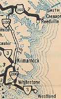
Improvements: paved from Cobbs Creek to Moon upon inception. In 1935, the rest of Mathews County VA 198 was paved In 1938, VA 198 was paved west to Cash The rest of VA 198 was paved in 1947. VA 198 has no multilane segments. Posting: Fully posted; Multiplexes: VA 3 (1.55 mi) VA 14 (1.69 mi) Legislative names: None Other names: Glenns Rd (Glenns to Cash); Dutton Rd (Cash to VA 3); Buckley Hall Rd (east of Mathews) Scenic Byway: Mathews to Moon (since 4/20/00) Comment: VA 198's old alignment on SR 601 contains what may be the last white border SR shield in Eastern Virginia. The 1939 VDOT report on primary system development had recommended that VA 198 be decommissioned east of Mathews. | ||||
| ||||||
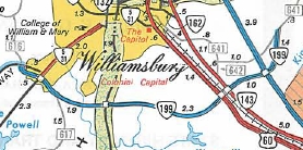
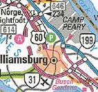
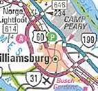
| ROUTE LOG I-64 (exit 234): 0 - 0 US 60: 1.79 - 1.79 VA 321: 4.31 - 6.10 VA 5 WB: 1.45 - 7.55 Williamsburg-James City Line: 0.22 - 7.77 VA 5 EB, VA 31: 0.24 - 8.01 James City-Williamsburg Line: 0.07 - 8.08 Williamsburg-James City Line: 0.07 - 8.15 James City-Williamsburg Line: 0.09 - 8.24 VA 132: 1.55 - 9.79 York-James City Line: 2.30 - 12.09 US 60: 0 - 12.09 VA 143: 0.09 - 12.18 I-64 (exit 242): 0.94 - 13.12 SR 641: 1.01 - 14.13 |
Creation: Appeared about 1975 as a Super 2. It initially ran from VA 5 to VA 143 Busch Gardens. This is the 2nd VA 199.
Adjustments: Around 1976, VA 199 east was extended to SR 641, including an interchange with I-64/VA 168.
Around 1993, a second piece of VA 199 opened between US 60 and I-64 in the Lightfoot area as new freeway. The two segments were connected west of Williamsburg about 1999.
Improvements: Paved upon designation; VA 199 was initially multilaned only at the VA 5-31 area. In 1976, VA 199 was multilaned at VA 132 and from US 60 to near SR 641. About 1989, VA 199 was fully multilaned except one small gap at Quarter Path Rd and another between VA 31 and VA 132. All segments of the western half of VA 199 were multilaned when they were opened. About 2004, VA 199 was multilaned at Quarter Path Rd. Per Kenny Bumbaco, VA 199 was multilaned from VA 31 to VA 132 between 2004-07, making VA 199 100% multilaned. Posting: Fully posted; Multiplexes: VA 5 (0.46 mi) Legislative names: Junius H. Moody Bridge, over US 60 Lightfoot (since 3/8/96); Robert S. Hornsby Memorial Bridge, over Longhill Rd (since 3/27/99) Other names: None Scenic Byway: No segments Comment: VA 199 is a limited-access road with both interchanges and at-grade intersections. Combined with I-64, it effectively forms a limited-access loop around Williamsburg. The segment from just north of VA 5 WEST to just south of I-64 is technically a full freeway. Is there any logical reason why VA 199 is not signed to the Colonial Pkwy? Froggie has 2 theories: First, this segment is SR 641 and has not been appreciably upgraded (unlike the rest of VA 199). Second, at the time VA 199 in that area was built and lasting as late as the early '90s, there were proposals for an additional York River crossing in the area, extending from where VA 199 ends. Proposals for a new crossing were eventually dropped in favor of the US 17 Coleman Bridge widening in the mid-90s. | |||||
| Previous VA 199's:
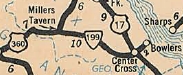
1960 ROUTE LOG US 360: 0 - 0 US 17: SR 667: 2.09 - 2.09 |
VA 199 #1: Appeared in July 1933 as a renumbering of VA 604. Ran from US 360 Millers Tavern to Bowlers Wharf (2 miles east of US 17).
About 1957, VA 199 was downgraded to SR 684. VA 199's old east end is literally in the river as a recent field visit discovered. |
1933 Official |
||||
| ||||||
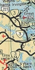
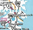
| ROUTE LOG VA 3: 0 - 0 VA 222: 4.08 - 4.08 VA 3 EB: 2.35 - 6.43 VA 3 WB: 0.09 - 6.52 Northumberland-Lancaster Line: 2.53 - 9.05 US 360: 10.18 - 19.23 |
Creation: Appeared in Appeared July 1933 as a renumbering of VA 605. It initially ran from White Stone directly to Kilmarnock then to US 360 Burgess. This is the 2nd VA 200.
Adjustments: About 1934, VA 200 was straightened out between Kilmarnock and Burgess to its current route. It had been using Tipers Ferry over the Great Wicomico River; private road through subdivision; SR 678; SR 609; all the SR 679 loops. In Jan 1941 (CTB), VA 200 was removed from SR 699 above the Wicomico River. In Aug 1941 (CTB), VA 200 was extended south over SRs 638/637 from White Stone to a ferry over the Rappahannock River, then replaced SRs 621/640 to VA 33. In Oct 1956 (CTB), VA 200 from VA 33 to White Stone was renumbered as part of VA 3. In Feb 1985 (CTB), VA 200 and VA 3 swapped alignments from White Stone to Kilmarnock.
Improvements: Paved upon designation only from White Stone to Kilmarnock The remainder was paved in late 1934. No multilane segments. Posting: Fully posted; Multiplexes: VA 3 (0.09 mi) Legislative names: Jessie Ball duPont Memorial Highway (entire route), since 12/15/88. Other names: Irvington Rd (White Stone to Kilmarnock); S. Main St (VA 3 duplex); E. Church St (Kilmarnock to Nortumberland County) Scenic Byway: Lancaster County portion of VA 200 (since 7/16/98) Comment: VA 200 is a very direct way to get to Northumberland County from the south. | |||||
| Previous VA 200's:
1960 ROUTE LOG VA 23: 0 - 0 VA 220: 10 - 10 CR 11: 8.06 - 18.06 |
VA 200 #1: Appeared in August 1928 as new primary routing. Ran
from VA 23 (now VA 8) south of Stuart 18.06 miles to past Ararat, about
3.6 miles short of the North Carolina line.
In July 1933, VA 200 was renumbered as part of VA 103 and all of VA 104. Today, it is SR 800 leaving VA 8; modern VA 103 and a couple SR loops (but not SR 747); it used SR 738 over to SR 773; SR 773 |
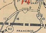 VA 200 #1 1929 Official |
||||
Previous: VA 180 |
Next: VA 201 - 220
Top | Virginia Hwy Index
Home
Page last modified 28 February 2015