< US 17W | Home | US 21 >
US 19 Business | US 19 ALT
US 219 | US 319
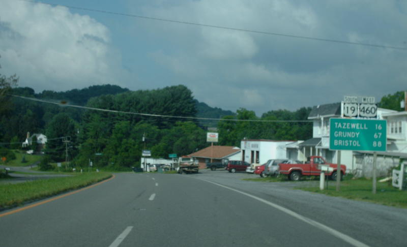
Photo: US 19 northbound west of Bluefield (photo by Mapmikey 8/1/08)
|
|
|
| ROUTE LOG |
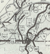
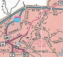
TN STATE LINE, VA 381 BEGIN: 0 - 0 VA 113: 0.23 - 0.23 US 11 BEGIN, US 11E END, US 11W, US 421 NB, VA 381 NB: 0.35 - 0.58 VA 113: 1.04 - 1.62 I-81 (exit 5), US 58: 1.74 - 3.36 Washington-Bristol Line: 2.65 - 6.01 VA 140: 7.18 - 13.19 US 11 NB: 0.90 - 14.09 US 58 ALT EB: 0.45 - 14.54 Russell-Washington Line: 10.28 - 24.82 US 58 ALT WB: 1.98 - 26.80 US 19 Bus: 5.63 - 32.43 US 19 Bus: 3.71 - 36.14 VA 80 EB: 4.76 - 40.90 VA 80 WB: 2.57 - 43.47 VA 369: 7.91 - 51.38 Tazewell-Russell Line: 0.20 - 51.58 VA 369: 0.20 - 51.78 US 460 WB: 5.22 - 57.00 US 19 Bus, US 460 Bus: 10.86 - 67.86 VA 16 ALT: 1.72 - 69.58 VA 16: 0.70 - 70.28 VA 61: 0.73 - 71.01 US 19 Bus, US 460 Bus: 1.75 - 72.76 US 460 EB: 10.71 - 83.47 VA 102: 3.71 - 87.18 WV STATE LINE: 0.80 - 87.98
|
Creation: Although an original US Highway, US 19 had a gap between Bluff City TN and Gauley Bridge WV. However, on May 28, 1927 AASHO approved US 19 to close the gap which included Virginia routing. Originally in late 1926 they were going to assign it to follow US 21 south to Wytheville then US 11 southwest to Abingdon but logical arguments that it was much longer and had a 50 mile unpaved segment changed their minds. So when finally resolved and designated several months later, it ran generally as it does today. In this routing, US 19 was added to:
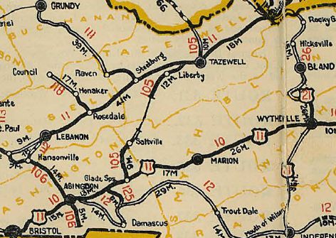
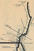
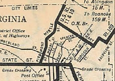
| US 11 and VA 10 from the Tennessee line to Abingdon. VA 106 from Abingdon to Hansonville VA 112 from Hansonville to Lebanon VA 11 from Lebanon to the West Virginia Line Here is a more detailed look at the history of US 19 from south to north Initially, US 19 entered Virginia via Pennsylvania Ave int Bristol, TN, then used State St west to Front St north to Spencer St northeast to Mary St east to Goodson St north to Danville Ave east to Fairview St north to Massachussetts Av east to Texas Av north which becomes Old Abingdon Hwy. which runs back into US 11-19 near the I-81 interchange. US 19 followed today's US 11 approaching Abingdon, then used Colonial Ave and crossed the railroad to modern US 11 at roughly the Bytt St location, then US 58 ALT northwest. US 19 followed today's US 19-58A to Hansonville except: SR 766 near Abingdon; SR 633 loop at Butts; SR 775 at Greendale; SR 876/802 at Holton
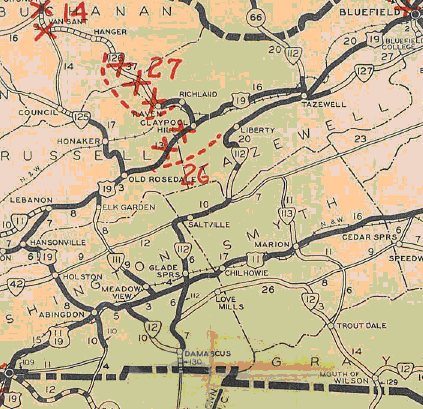
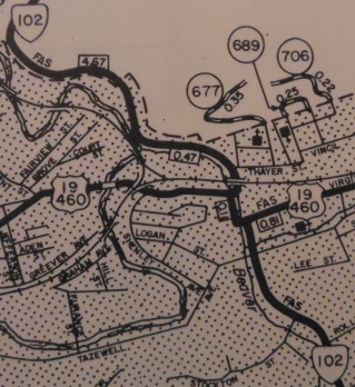
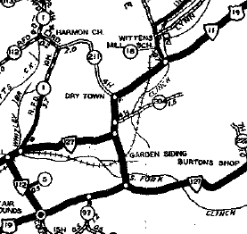
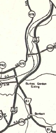
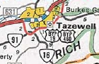
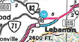
Leaving Hansonville, US 19 used today's 19 up to SR 674, then abandoned alignment on the north side to Sunset Dr; US 19; SR 841 (except initially used SR 758 loop) to US 19 Bus; tiny bit of 19 Bus; Gilbert St/Old Fincastle Rd; VA 82; US 19 Bus through Lebanon. East of Lebanon, US 19 used SR 656 loop back to 19. After a brief stretch of today's US 19, US 19 followed the SR 872 loop near VA 80 EB. US 19 followed more of today's 19 but near VA 80 WB stayed north of the creek on Old Rosedale Hwy and some abandoned alignments until around SR 644. East of here, US 19 more closely followed it current path although in the field it appears old alignment pieces are visibe to the north side. Before VA 369, US 19 originally used SR 770 to cross into Tazewell County, then SR 609 north back to US 19. US 19 followed its current path to Claypool Hill except it used the SR 705 loop. At Pounding Mill, US 19 used SR 637 but otherwise followed US 19-460 and then Bus US 19-460 to VA 16 ALT. Initially, US 19 followed Old Fincastle Tpk in western Tazewell, then current US 19 Bus through Tazewell, tehn Ben Bolt Rd east to VA 61. US 19 then followed VA 61 north to SR 678 Market St. US 19 followed SR 678 north to SR 645 east which used to connect back to modern 19-460. US 19 followed today's 19 to Bluefield except: SR 781; SR 680 loops in Springville; SRs 665 and 744/1520 Shannandale. There are other visible unnumbered loops that are visible to the north side of US 19-460. In Bluefield US 19 used Greever and East Sts Adjustments: In Feb 1930 (CTB), US 19 was rerouted to remain on Piedmont Ave north to Euclid, then northeast out of town. Mary St/Goodson St/Danville Ave/Fairview St/Massachusetts Ave became part of an extended VA 109. but Texas Ave and Old Abingdon Hwy became SR 645 (now all within the City of Bristol and unnumbered now). About 1934 (bridge date), US 19 was removed from the Old Rosedale Hwy alignments. In July 1937 (CTB), US 19 was removed from Colonial Ave in western Abingdon and placed on current US 11. In Feb 1938 (CTB), US 19 was placed on its US 19-460 Bus routing through all parts of the town of Tazewell. In Oct 1938 (CTB), US 19 was removed from the SR 680 loops in Springville. In Jan 1940 (CTB), US 19 was removed from Greever/East St in Bluefield. In Apr 1940 (CTB), US 19 was placed on modern US 19 Business in Lebanon. A little bit of the old routing in Lebanon became VA 64 but is all unnumbered today save a speck of VA 82. US 19 was also removed from SR 656 east of Lebanon. In June 1947 (AASHO), US 19 was moved to its current Abingdon Bypass, replacing SR 670. The old route through Abingdon remained parts of US 11-58 and US 19 ALT (now US 58 ALT). In May 1952 (CTB), US 19 was given one-way spilts in Bristol: NB used 4th north to State west to Piedmont north SB used Piedmont, then Cumberland east to Lee, then south along 5th and Lee to Anderson, then south on Anderson. In Aug 1955 (CTB), US 19-58 ALT was removed from all the SR loops between Abingdon and Hansonville. In Aug 1958 (CTB), US 19 was removed from SR 770 in Russell/Tazewell Counties In Dec 1966 (CTB), US 19 was rerouted in Bristol to its current routing.
Between 1962-75, US 19 was rerouted in Bluefield to a less direct route across Bluefield. It left Graham Ave at Walnut, then south to what is now Virginia Ave then east back out of town. Originally it had used Graham Ave all the way through.
In May 1970 (AASHO), US 19 was put on its bypass of Tazewell (though bridges are dated 1974), leaving behind US 19-460 Bus.
In March 1976 (CTB), US 19 was removed from SR 841 south of Lebanon. In 1985, US 19 was placed on its bypass to the south of Lebanon (first mentioned in the May 1970 CTB for approving its path), leaving behind US 19 Business.
Improvements: Upon designation in 1927, US 19 was paved everywhere except from Hansonville to Lebanon. In 1929, the rest of US 19 was paved The First segment of US 19 to be multilaned was in the Holston area, in 1965. I believe US 19 was multilaned in 1966 when it was put on Commonwealth and Euclid Ave east to near VA 113. In 1968, US 19 was multilaned from Abingdon to Holston; about Springville to Bluefield WCL. In 1969, US 19 was multilaned from Holston to Hansonville; east end of today's US 19-460 Bus to Springville In 1973, US 19 was widended from Claypool Hill to Pounding Mill In 1975, US 19 was widened from Hansonville to Lebanon; Tazewell Bypass In 1976, US 19 was widened from VA 140 to Abingdon; Pounding Mill to Tazewell Bypass In 1978, US 19 was multilaned from 5 miles west of VA 80 Eb to 2 miles past VA 80 WB. In 1995 or 1996, US 19 was widened from the Russell/Tazewell Line to Claypool Hill. In 1997 or 1998, US 19 was widened on the Lebanon bypass. In 2002, US 19 was multilaned from the Lebanon Bypass to 5 miles from VA 80; 2 miles east of VA 80 to Tazewell County. The remaining 2-lane segments are: US 11 duplex between VA 113 and VA 140; Town of Bluefield Posted: Fully posted; 3 cutouts in Bluefield were still up in 2008 but only 1 remains as of 2021; Bristol cutouts removed in 2003 Multiplexes: US 11E, US 421, VA 381 (0.58 mi) US 11 (13.51 mi) US 58 ALT (12.22 mi) US 460 (26.47 mi) Legislative names: Robert Porterfield Memorial highway, Hansonville to Abingdon (since 4/4/72); Harry Carter Stuart Highway, Hansonville to Big Cedar Creek east of Lebanon (since 2/18/88); Trail of the Lonesome Pine, east end of Lebanon Bypass to Bluefield except US 19 Bypass of Tazewell (since 3/24/30) Colonel Thomas McCulloch Memorial Bridge over N. Holston River (since 3/6/42); Charles Hayes Gilmer Bridge over Big Cedar Creek (since 8/24/44) Other names: Commonwealth Av/Euclid Ave (Bristol); Lee Hwy (US 11 duplex); Main St (Abingdon); Virginia Ave/Walnut Ave (Bluefield) Scenic Byway: east end of Lebanon Bypass to WV Line except Tazewell Bypass (since 3/8/93) Truck Route: A Truck US 19 exists in Bristol, running between US 19/US 421/VA 381 using Goode St, Cumberland St, Randall St and Moore St back to US 11-19 at the now unposted northeast end of VA 113. Comments: US 19 is a decent (albeit longer) alternative (with US 460) to I-81 between Abingdon and Christiansburg. Seems to me since US 19 is a throguh route, it should be added to I-81 via VA 381/I-381 and replace VA 140 in Abingdon. US 19 could also be added to the US 460 routing around Bluefield VA/WV as the two routes meet again in Princeton WV. | |||||||||||||||||||

Previous: US 17W |
Next: US 21
US 219 | US 319
Top | Virginia Hwy Index
Home
Page last modified 1 February 2022