|
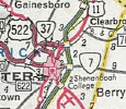
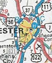
From:  near Kernstown (Frederick County) near Kernstown (Frederick County)
To:
 near Stephenson (Frederick County) near Stephenson (Frederick County)
Current Length: 9.06 miles
|
|
|
|
|
ROUTE LOG
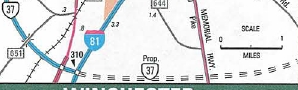
I-81 (exit 310): 0 - 0
US 11: 0.50 - 0.50
US 50: 4.73 - 5.23
US 522: 1.67 - 6.90
US 11: 2.16 - 9.06
|
|
Creation: Initially described in its current routing in the Mar 1965 (CTB) as the proposed Winchester Bypass. This is the 5th VA 37.
Adjustments:
In Dec 1965 (CTB) the 4 miles of the proposed Winchester bypass from US 50 northeast to US 11 was officially put into the primary system.
Official maps show it open from US 522 north to US 11 in 1969.
US 50 to US 522 was opened about 1972.
US 50 south to I-81 was opened about 1978.
Officials since 1998 show a proposed extension of VA 37 southeast across US 522 to US 17-50.
VA 37 appears
|
VA 37 extended south to I-81
|
VA 37 proposed to head to US 17-50
|
Improvements: Paved freeway from its inception.
Posted: Fully posted; Since 2008 there has been an error US 37 shield on I-81 SB approaching the US 11 Stephenson exit.
Multiplexes: None
Legislative names: None
Other names: Virginia Ave/Court St/Washington St/Church St (Amelia CH); Five Forks Rd (Amelia County)
Scenic Byway: No segments
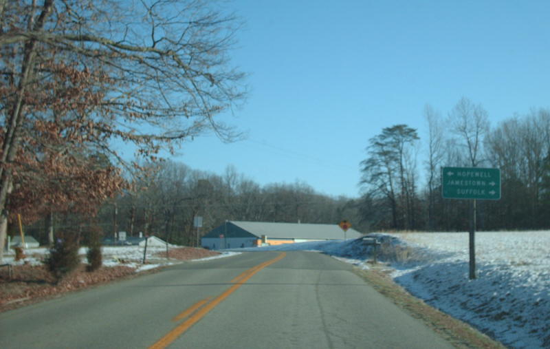
Comment: VA 37 is a very useful route to avoid downtown Winchester.
Note that on the southern end VA 37 is not a full freeway in its interchange with I-81. There are stoplights at this interchange.
If VA 37 is extended southeast to US 522 or US 17-50, will any of those routes be put on the highway to bypass Winchester?
|
| Previous VA 37's:
1932 ROUTE LOG
BEGIN VA 37: 0 - 0
VA 605: 7 - 7
VA 627: 4 - 11
VA 605 SB: 3 - 14
VA 605 NB: 1 block - 14
VA 628: 9 - 23
VA 628Y: 1 block - 23
VA 606: 3 - 26
VA 632: 15 - 41
VA 13 EB: 6 - 47
VA 13 WB: 1 - 48
VA 37E, VA 37W: 3 blocks - 48
GAP IN ROUTE
VA 37E, VA 37W, VA 607: 0 - 48
VA 607Y: 1 - 49
VA 620: 8 - 57
VA 610: 6 - 63
VA 611: 3 - 66
VA 611: 12 - 78
VA 612: 3 - 81
VA 624: 18 - 99
US 1, VA 31, VA 38: 1 - 100
VA 617: 15 - 115
VA 702: 1 - 116
VA 49: 18 - 134
US 15 SB, VA 32 SB: 2 - 136
US 29, VA 28 SB: 0.5 - 136.5
US 15 NB, VA 28 NB, VA 32 NB: 1.5 - 138
VA 706: 10 - 148
VA 723: 5 - 153
VA 16: 4 - 157
US 211 WB, VA 21 WB: 1 - 158
VA 728: 6 - 164
US 211 EB, VA 21 EB: 3 - 167
VA 55 EB: 15 - 182
VA 815: 1 - 183
VA 55 WB: 2 - 185
VA 54: 9 - 194
US 50 EB, VA 36 EB: 9 - 203
US 11 SB, VA 33 SB: 1 - 204
US 11 NB, US 50 WB, VA 33 NB, VA 36 WB: 1 - 205
US 340 SB, VA 826: 11 - 216
VA 823: 2 - 218
WV STATE LINE: 3 - 221
1934 ROUTE LOG
US 360: 0 - 0
Chesterfield-Richmond Line: 0.50 - 0.50
VA 145: 10.65 - 11.15
VA 144: 5.35 - 16.50
US 1: 1.70 - 18.20
Prince George-Chesterfield Line: 7.70 - 25.90
VA 36 WB: 0.60 - 26.50
VA 36 EB: 4.30 - 30.80
VA 10: 6.00 - 36.80
1940 ROUTE LOG
VA 36: 0 - 0
VA 10: 13.42 - 13.42
1950 ROUTE LOG
NC STATE LINE: 0 - 0
VA 32: 13.74 - 13.74
|
|
VA 37 #1: Appeared in 1923 as a renumbering of VA 7 from Westland to Cedarville; new primary routing from Cedarville to Berryville via Winchester; a duplex with VA 361 from Berryville to West Virginia.
|
More specifically, VA 37 began at Westland and followed SR 695 to White Stone, then VA 3 north to Kilmarnock. VA 37 continued today's VA 3 through Brookvale to Lancaster (used SR 790 at Camps Millpond). VA 37 then used SR 600 to McNeals Coner, then VA 201Y and VA 201 to Lively.
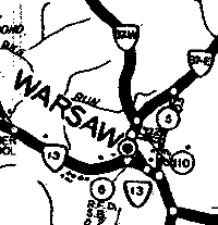
VA 37 then used VA 3, then SR 622 west through Nuttsville to Litwalton, then VA 354 north back to VA 3. I believe VA 37 followed VA 3 to Warsaw except it used old SR loops through Farnham and Emmerton. 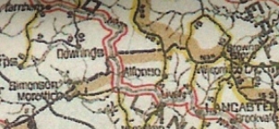
VA 37 in Lancaster County
At Warsaw, VA 37 used VA 3 Business, then SR 690 through Farmers Fork over to Templemans. VA 37 used SR 766 and SR 767 through Templemans, then VA 3 to Montross.
VA 37 followed VA 3 to Oak Grove except using SR 647 at Chandlers Millpond; SR 659 in the Flat Iron area; SR 639/654 at Potomac Mills. There are a few old VA 3 alignments visible which are not roads anymore that likely were VA 37 as well.
VA 37 followed the SR 1xxx behind the school at Oak Grove which used to connect directly to SR 634 near King George County line. VA 37 used SR 681 at Rollins Fork; SR 680 at Index; SR 647 at Shiloh; SR 679 near Weedons Fork; SR 686 west of US 301; SR 678 at King George CH; SR 677 at Comorn as it followed VA 3's general routing through King George County.
VA 37 pretty much used today's VA 3 to VA 3 Business through Fredericksburg. West of Fredericksburg, VA 37 used current VA 3 to Stevensburg. VA 37 used SR 600 through Stevensburg. It appears VA 37 used VA 3 to US 522, then SR 686 west to today's US 15 Business (cutoff by Culpeper bypass now). VA 37 used US 15 Bus, then unnumbered Orange Rd, then US 522 through central Culpeper.
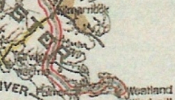
VA 37 avoids Irvington
|
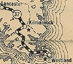
VA 37 non-direct to Kilmarnock
|
In Dec 1923 (CTB), VA 37 was rerouted at White Stone to head west to Irvington on current VA 200, then cut west on SR 646 to Christ Church, then north on VA 222 back to VA 200 and over to Kilmarnock.
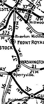
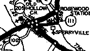
North of Culpeper US 522 follows a path that has been totally rebuilt. There are numerous visible old alignments that are no longer public road. A few pieces are drivable that were VA 37: SR 737 near Norman; SR 707/695 Boston; SR 655/620 near Sperryville.
In Sperryville, VA 37 used US 522, then SR 1002 northeast across the Thornton River (no crossing now). VA 37 followed US 211-522 Business through Washington, and SR 678 at Massies Corner. VA 37 followed US 522 north to Front Royal except used SR 641/628 to Flint Hill; SR 657 in Huntley; SR 610 at Chester Gap.
In Front Royal, VA 37 followed US 522 then Main St west to US 340. VA 37 stayed on Royal Rd to the S. Shenandoah, then used Old Winchester Pike to the N. Shenandoah, then SR 637 back to US 340/522. VA 7 followed US 522 to Winchester except it used SR loops through Double Tollgate and another a little north of that.
VA 37 followed US 522 in downtown Winchester, then VA 7 and 7 Business east to Berryville. VA 37 then used US 340 to West Virginia except it used SR 617 in Gaylord.
|
VA 37 Culpeper to W. Virginia
|
It appears that by 1924, VA 37 was removed from SR 686 at Culpeper and put on current VA 3.
When US routes were assigned in late 1926, VA 37 was untouched except from Berryville to West Virginia became part of US 340.
In 1928 (bridge date), VA 37 was removed from SR 634 west of Oak Grove in Westmoreland County, leaving behind CR 206.
In 1929 (bridge date), VA 37 was removed from today's SR 639/654 at Potomac Mills in Westmoreland County, leaving behind CR 103/104.
In 1930 (bridge date), VA 37 was removed from SR 1002 in Sperryville, leaving behind CR 111.
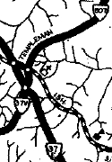
In Dec 1930 (CTB), VA 37 was split into VA 37E and VA 37W between Warsaw and Templemans. VA 37 (current SR 690) became the VA 37W routing.
In Aug 1932 (CTB), VA 37 was extended east 0.08 miles to the Westland Wharf.
In July 1933, VA 37 was renumbered as VA 3 from Westland to Winchester; VA 7 from Winchester to Berryville; US 340 remained from Berryville to West Virginia.
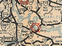
VA 37 #2: Appeared in July 1933 as a renumbering of VA 407, beginning at US 360 in Richmond and following today's VA 10, except at Chesterfield used SR 655 to cut the corner and in Chester it used SR 681 approaching Chester. VA 37 followed VA 10's current path to Hopewell.
In Hopewell, VA 37 used Randolph St cut east at City Point Rd to Hopewell St, then followed the twisted Hopewell St southeast to Teminal St south back to Randolph Rd, then current VA 10 to Garysville where it ended at then-VA 10 (now SR 609).
In Aug 1934, VA 37 swapped places with VA 10. The 1933 Official erroneously shows VA 37 using Randolph all the way through Hopewell which did not become the highway through town until 1948.
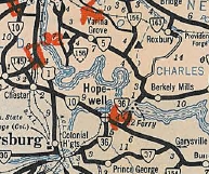
VA 37 #3: Appeared in Aug 1934 as a renumbering of VA 10. Ran from VA 36 into Ft Lee. VA 37 followed 'A' Ave as it arc around the Army Post, coming out at the SR 630-634 junction near Prince George CH. VA 37 used SR 634, then VA 106 through Prince George CH, then SR 609 Old Stage Rd. VA 37 followed SR 609 over to current VA 10 Garysville.
In Oct 1940 (CTB), VA 37 was renumbered as VA 106.
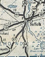
VA 37 #4: Appeared Oct 1940 as a renumbering of VA 53, running from VA 32 near Suffolk southwest through Whaleysville and into North Carolina.
About 1951, VA 37 was renumbered as part of US 13.
VA 37 Richmond to Garysville
|
VA 37 Petersburg to Garysville
|

VA 37 direct through Hopewell
|
VA 37 #4
|
VA 37-E: Appeared Dec 1930 as partial new primary routing and a renumbering of VA 608. Ran between VA 37-37W in Warsaw and VA 37-37W in Templemans.
In July 1933, VA 37-E became part of VA 3. Today it is also part of VA 3 Business.
VA 37-W: Appeared Dec 1930 as a renumbering of VA 37 between Warsaw and Templemans.
In July 1933, VA 37-W became part of VA 202. Today it is SR 690.
The Official maps showed both segments as just VA 37.
VA 37Y?: The 1932 Rappahannock County map shows a primary route triangle in Sperryville between VA 37 and US 211/VA 21. Before 1930, US 211/VA 21/VA 37 used today's SR 1002 northeast out of town. In 1930, VA 37 was put on today's US 522 and US 211/VA 21 was removed from Sperryville as it runs now. The old US 211/VA 21 approach into Sperryville is shown as primary on both the 1932 and 1936 Rappahannock County maps. The best guess for the number of the segment is VA 37Y. Much less likely is VA 21Y or an extension of VA 16.
In July 1933, this most likely became VA 3Y. Today it is SR 1001.
VA 37-E
|
VA 37-W
|
VA 37Y?...CR 102 clearly ends at a primary route
|
|
Previous: VA 36 |
Next: VA 38
Top | Virginia Hwy Index
Home
Page last modified
17 February 2015
|