< VA 7 | Home | VA 9 >
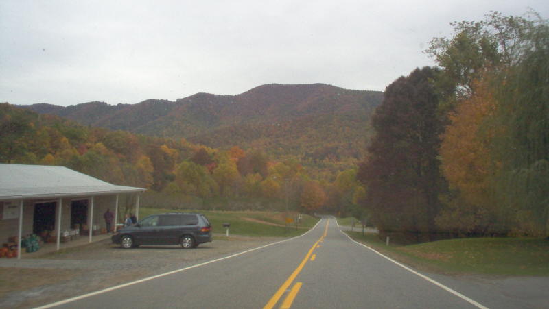
Photo: VA 8 in the Autumn, between Woolwine and Floyd (photo by Mapmikey 10/26/06)
|
|
|
| ROUTE LOG |
US 11: 0 - 0 I-81 (exit 114): 0.99 - 0.99 Floyd-Montgomery Line: 9.25 - 10.24 US 221: 10.32 - 20.56 VA 48: 5.96 - 26.52 Patrick-Floyd Line: 0.34 - 26.86 VA 40: 6.14 - 33.00 VA 57: 6.22 - 39.22 US 58 WB: 3.89 - 43.11 US 58 EB, Begin US 58 Bus: 2.01 - 45.13 US 58 Bus EB, VA 8 Bus: 1.01 - 46.14 VA 8 Bus: 0.60 - 46.74 VA 103: 3.67 - 50.41 NC STATE LINE: 5.08 - 55.49
|
|
| Previous VA 8's:
1922 ROUTE LOG VA 1: 0 - 0 VA 13: 52 - 52 VA 9 SPUR: 33 - 85 VA 9 SPUR: 35 - 120 |
VA 8 #1: Began in January 1918 as an original state route defined by the general assembly:
Route 8: Mathews CH, Saluda, Tappahannock, Port Royal, Fredericksburg More specifically, VA 8 began at Mathews CH, then followed VA 198 to Cobbs Creek, then VA 3 northwest. At the Piankatank River, VA 8 used Mathews SR 701 and Middlesex SR 655. VA 8 picked up VA 33 west, likely using the SR 638 loop at Christchurch. At VA 227, VA 8 used SR 641 to SR 629 back to VA 33 into Saluda. 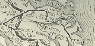
VA 8 Saluda to Mathews CH VA 8 picked up US 17 Bus and US 17 north from Saluda, then used SR 614 in the Warner area. After more 17, VA 8 used SR 695 in the Church View area. VA 8 the used US 17 to Jamaica, then SR 647. A bit more 17 was followed by SR 608 Glebe Landing Rd. In Essex County, VA 8 followed SR 720 from Laneview to Montague; SR 602 from Montague to Oakley, then across US 17 and still on SR 602 looping over to Center Cross. After a bit of US 17, VA 8 used SR 718 then crossed US 17 onto another loop that is no longer a road; a little more 17 to Ozeana; then looped back and forth with US 17 without using it all the way to SR 609 past Dunnsville (SR 1103/1102/1001 loops and some that are no longer roads); VA 8 used a bit more of 17 then used an alignment slightly west to cross Piscataway Creek; then used "Old Seventeen" and SR 715 to Brays Fork. 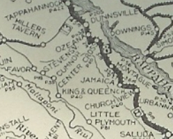
VA 8 Tappahannock to Saluda VA 8 used US 17-360 into Tappahannock (except it used SR 698 loop and SR 1003). VA 8 then followed SR 657 west which no longer connects to SR 627. VA 8 used SR 627 then SR 716 back to US 17, then the SR 624 loop in Caret. The 1922 Auto Trails map shows VA 8 using SR 624 to Lloyds, then SR 631 to Champlain, then an SR 11xx loop, then a little SR 633 over towards Occupacia. VA 8 may have used SR 632 and SR 658 which no longer connects back to US 17 at Loretto. VA 8 then used US 17 to the Caroline County line except the bridge over portobago Creek is to the north a little (but still there). VA 8 seems to have followed US 17 to Port Royal (using the NB alignment where the route splits). VA 8 used the still visible old bridge to the north of US 17 over Goldenvale Creek. The 1922 Auto Trails suggests that after Rappahannock Academy, then used SR 719 north to (no longer connects to) SR 614 then back to US 17 to New Post. VA 8 then used SR 698 which no longer connects back to US 17 Bus but the two old bridges at Ruffins Pond are visible to the north of US 17 Bus. VA 8 followed 17 Bus generally to SR 638, then likely used Old Airport Rd to head towards Fredericksburg, which used to connect with Dixon St. VA 8 then turned onto Princess Anne St and the route ended at VA 1 National Rd (now Lafayette Blvd). 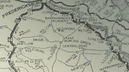
VA 8 Fredericksburg to Tappahannock In Dec 1921 (CTB), VA 8 east was truncated to end at VA 9 (now VA 33) Saluda. most of the Saluda to Mathews route became non-primary at that time, with Mathews CH being served by VA 9 SPUR #3 from Gloucester CH. In 1923, VA 8 was renumbered as VA 38 except: Mathews CH to Cooks Corner became secondary routing Cooks Corner to Saluda became VA 30 |
|||||||||||||
|
|
|
| ROUTE LOG |
VA 8: 0 - 0 US 58 Bus EB: 0.5 - 0.5 US 58 Bus WB, VA 8: 0.5 - 1.0
|
Creation: This VA 8 Business appeared in 2014 or 2015 as a renumbering of VA 8 through central Stuart.
|
Adjustments: None Improvements: Paved upon inception; No multilane segments Posted: Fully posted; Multiplexes: US 58 Bus (0.5 mi) Legislative names: None Other names: Patrick Ave/W. Blue Ridge St Scenic Byway: no segments Comment: VA 8 Business very closely parallels VA 8 bypass for its first 1/3 of a mile or so. | |||||
Previous: VA 7 |
Next: VA 9
Top | Virginia Hwy Index
Home
Page last modified 28 November 2015