|
VA 19 to 24 < VA 13 to 18 | Home | VA 25 to 30 > |
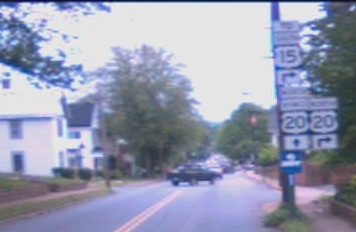
Photo: A scene that was last seen near Rochester, NY in the 70's has been erroneously replicated in Orange (courtesy William Payne) |
||||||||||||||||||||||||||||||||||||||||||||||||||||||||||||||||||||||||||||||||||||||||||||||||||||||
| U.S. 19 |
| VA 19 not currently assigned | ||||||||||||||||
| Previous VA 19's: |
VA 19: An original state highway. Began at VA 2 (curr. US 15) in Dixie and proceeded east to Richmond. In 1929 VA 19 was extended west to VA 28 (curr. US 29) at Covesville. VA 19 was renumbered in its entirety to VA 6 in 1933, and generally remains that way today. Note that current VA 310 is actually part of the original VA 19, as is River Road in Richmond.
VA 19Y: Created in December 1930 (CTB minutes) as a spur from VA 19 (curr VA 6) towards Schuyler. This was renumbered as VA 6Y in July 1933. Today it is SR 800. |
|||||||||||||||
|
|
|
| ROUTE LOG |
US 15: 0 - 0 AL-BK LINE: 20 - 20 VA 6 EB: 0.5 - 20.5 VA 6 WB: 0.5 - 21 VA 53: 18 - 39 VA 388: 0.5 - 39.5 VA 317: 0.5 - 40 I-64 (exit 121): 0.5 - 40.5 CHR-AL LINE: 0.5 - 41 US 250 Bus WB: 1 - 42 US 250 WB, US 250 Bus END: 1 - 43 AL-CHR LINE: 0 - 43 US 250 EB: 0.5 - 43.5 OR-AL LINE: 13 - 56.5 US 33 EB: 2 - 58.5 US 33 WB: 0.5 - 59 VA 231: 6 - 65 VA 20 Bus: 6 - 71 US 15 NB: 0.5 - 71.5 US 15 SB: 3 blocks - 71.5 VA 20 Bus: 0.5 - 72 US 522: 10 - 82 VA 3: 13 - 95
|
Creation: Appeared in July 1933 as a 2 piece discontinuous route - 1. US 15 Dillwyn to VA 6 Scottsville, replacing all of VA 316 2. VA 231 Somerset to VA 3 Wilderness, replacing all of VA 702 and new routing Somerset to Orange. This is the 2nd VA 20.
| Adjustments: By 1937 VA 20 piece two was extended west to US 33 Barboursville over a previously unnumbered road. Between 1939-41, VA 20 piece one was extended 6 miles north of Scottsville along current SR 795. Between 1942-44, this was extended all the way along current SR 795 to Charlottesville (thus eliminating the original VA 239). Between 1948-53 the 2 sections were connected by overruning SR 615 between Charlottesville and Barboursville. VA 20 was also shifted to its current route between Charlottesville and Scottsville, leaving behind a part of VA 53 and SR 795. This routing had been SR 613. Posting: Fully Posted. There are cutouts (thanks Gribblenation) up in Orange still at US 15-VA 20 Bus jct and at VA 20-VA 20 Bus west of downtown. Error US 20 signs appear in Orange (pic at top of page), and just west of Montpelier. Comment: I'd recommend this as a scenic back road between Orange and Charlottesville. | Previous VA 20's: |
VA 20 #1: An original state highway. The 1922 Auto Trails Map shows VA 20 beginning at VA 18 (curr. US 501) in Brookneal and went to Keysville, Lunenburg, Victoria, Kenbridge, Blackstone, then west to Crewe, Burkeville, then east to Amelia, ending in Richmond (a road did exist from Keysville to Burkeville, but was not numbered).
In 1923, VA 20 was assigned to that direct routing from Keysville to Burkeville, leaving behind VA 323 (curr VA 40) and part of VA 10 (curr US 460) In 1927 US 501 tagged along from Keysville to Burkeville and US 60 from there to Richmond. VA 20 was extended west over unnumbered routes to US 311 (curr US 220 Bus) Rocky Mount, with a discontinuous section in Pittsylvania County. In 1929 VA 20 east was truncated to Keysville by these US Hwy sections (curr US 360). VA 20 also was extended west from Rocky Mount to Patrick County, just past Endicott. In 1930-31, VA 20 became continuous, and was extended west to a couple miles short of VA 23 (curr. VA 8) in Woolwine. All westward extensions were over previously unnumbered roads. For no apparent reason, VA 20 was renumbered to VA 40 in July 1933. VA 20 ALT: Was the number for current VA 20 Business in Orange. It existed from March 1956 to at least 1967, before being changed to the business designation |
|||||||
| U.S. 21 |
| VA 21 not currently assigned | ||||||||||||||||
| Previous VA 21's: |
VA 21: An original state highway. In 1922 ran from VA 3 (curr. US 11) New Market to Luray, Sperryville, Washington, Warrenton, New Baltimore, Manassas, Fairfax, Arlington, and Washington DC.
In 1923, VA 21 was rerouted from New Baltimore-Manassas-Centreville to New Baltimore-Gainesville-Centreville. The Manassas routing became VA 211 (curr VA 215 and part of VA 28). In 1927, US 211 was paired with VA 21 in its entirety, and thus VA 21 came to a permanent end in 1929. Today it is US 211 and US 29 north of Warrenton. |
|||||||||||||||
|
|
|
| ROUTE LOG |
US 250: 0 - 0 VA 231: 5 - 5 LO-AL LINE: 4 - 9 US 15: 4 - 13 US 33 WB: 6 - 19 VA 208 WB: 5 - 24 US 33 EB: 1 - 25 US 522, VA 208 EB: 5 - 30
|
Creation: Appeared in 1933 as the 2nd VA 22, from VA 5 (curr. US 250) Shadwell to US 15 & VA 4 Boswells Tavern. All of this had been a small part of original VA 39.
| Adjustments: It was extended east to its current end between 1945-47, replacing the original alignment of US 33. Posting: Fully Posted. Cutouts existed on VA 231 at Cismont (thanks Gribblenation!) until October 2005. Comments: VA 22 west of Louisa runs through some very scenic horse country. VA 22 could be dropped from US 33 to Mineral, as VA 208 has been multiplexed over it (and beyond in both directions since 1974). VA 22 is blown off by I-64 but has a 4-lane right-of-way at its underpass. | Previous VA 22's: |
VA 22 #1: An original state highway in place by 1922. It began at VA 10 (curr. US 11) in Salem and proceeded north to WV near Paint Bank. Currently this is VA 311.
In 1928-29, VA 22 was "extended" north to US 60 (curr. VA 159) at Crows, replacing original VA 143 (where today's 311 goes back through Va. before reaching I-64.) The WV piece in between was WV 81. In 1930-31, VA 22 was extended south to US 311 (curr. US 220) south of Roanoke. VA 22 was eliminated in July 1933. Everything north of Salem became the VA 311 US route extension, and the piece below Salem became VA 119. . |
|||||||
| U.S. 23 |
| VA 23 not currently assigned | ||||||||||||||||
| Previous VA 23's: |
VA 23: An original state highway in place by 1922. It originally ran from VA 12 (curr US 58) Stuart and continued north through Blacksburg and into West Virginia towards Bluefield (as WV 24).
VA 23 was extended south to the NC state line below Stuart (as NC 661) by 1927. This lasted until 1933, when the entire route was renumbered VA 8. Today this is all of VA 8, VA 100 between VA 61 and Pearisburg, and US 460. |
|||||||||||||||
|
|
|
| ROUTE LOG |
US 220 Bus, US 221, VA 116: 0 - 0 I-581, US 220: 0.5 - 0.5 RO-ROA LINE: 1.5 - 2 Blue Ridge Pkwy: 3 - 5 BD-RO LINE: 1 - 6 VA 122: 17 - 23 VA 43 NB: 6 - 29 VA 43 SB: 3 - 32 CB-BD LINE: 7 - 39 US 29: 10 - 49 US 501 SB: 4 - 53 US 501 NB: 1 - 54 AP-CB LINE: 10 - 64 US 460 WB: 1 - 65 US 460 Bus, VA 26: 8 - 73 US 460 EB, VA 131: 1 - 74 BK-AP LINE: 11 - 85 US 60: 9 - 94
|
Creation: Appeared in July 1933 as the 2nd VA 24. It had the same general routing of today but also continued west along current US 460 to US 11 in Salem. It replaced all of original VA 207, half of original VA 43, all of original VA 308, and half of original VA 306. There was a large gap from 6 miles east of Stewartsville to the Bedford-Campbell County Line.
| Adjustments: By July 1936, VA 24 was continous in the VA 122 vicinity, but had a 2-mile multiplex with VA 122, as VA 24 was using SR 801. Today's routing in this area was established between 1942-44. VA 24 was truncated to its current end in Roanoke when US 460 was extended west around 1946. In 1999 VA 24 was moved onto the US 460 Appomattox Bypass, and the old route became an extended VA 131. Posting: Fully posted, though not well at Roanoke. Cutout sign was still up in Vinton July 2005 (photo by Chris E). Roanoke embossed cutout was up as late as 1991 Comment: Passes Appomattox Court House National Historic Park. VA 24 would be an excellent alternative for US 460 from Appomattox to Roanoke if it weren't for the stretch between Evington and current VA 43, which is very gnarly. When I drove this I passed a pickup truck lodged in a tree where it didn't make the turn.... | Previous VA 24's: |
VA 24 #1: An original state route. Ran from VA 12 (curr US 58 Bus) Emporia southwest through Brink to NC. This scan of the 1922 Rand McNally shows the earliest alignment
In 1923, VA 24 was rerouted to go directly south to then-NC 40 via Skippers. This was mostly new routing, and shared just the northernmost 1/2 mile with the original VA 24 (Main St. in Emporia). The old VA 24 route to NC went unnumbered after that, and today is SR 627. By 1927, VA 24 was extended to Petersburg over new routing to VA 35, and it replaced VA 35 for 10 miles to Petersburg. It attracted the attention of US 17-1 in 1927, who moved in and took over for good by 1929. Today this original VA 24 is part of US 301. | ![]() |
||||||
Previous: VA 13 - 18 |
Next: VA 25 - 30
Top | Virginia Hwy Index
Home
Page last modified 29 March, 2006