< VA 8 | Home | VA 10 >
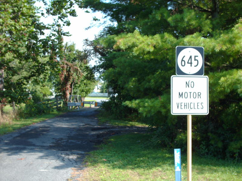
Photo: VA 9 used this now-closed bridge on SR 645 in McDowell (photo by Mapmikey 8/30/08)
|
|
|
| ROUTE LOG |
VA 7, VA 7 Bus: 0 - 0 VA 287: 5.31 - 5.31 WV STATE LINE: 7.77 - 13.08
|
Creation: Appeared in Oct 1940 as a renumbering of VA 238. Ran as it does today. This is the 4th VA 9.
|
Comment: VA 9 is under scrutiny because it has become a major commuting route from Chares Town, WV to Northern Virginia. WV is to widening its half, but VDOT does not seem interested in following suit. The historical village of Hillsboro is a particular choke point on the route. By coincidence, Maryland does not currently have a MD 9. Changing MD 51 to MD 9 would result in a 3-state Multi-State Route 9. | Previous VA 9's:
1922 ROUTE LOG BEGIN VA 9: 0 - 0 VA 9 SPUR EB: 35 - 35 VA 9 SPUR WB: 1 - 36 VA 13 EB: 52 - 88 VA 1 SB, VA 13 WB: 2 - 90 VA 1 NB: 16 - 106 VA 2 NB: 55 - 161 VA 2 SB: 1 - 162 VA 28: 14 - 176 VA 18: 23 - 199 VA 3 SB: 18 - 217 VA 3 NB: 1 - 218 VA 17 EB: 8 - 226 VA 17 WB: 8 - 234 WV STATE LINE: 30 - 264 1939 ROUTE LOG US 1: 0 - 0 Fairfax-Prince William Line: 2.15 - 2.15 Fairfax City-Fairfax Line: 13.09 - 15.24 VA 236: 1.00 - 16.24 US 29, US 50, US 211: 1.00 - 17.24 Fairfax-Fairfax City Line: 0 - 17.24 VA 7: 6.60 - 23.84 Arlington-Fairfax Line: 6.60 - 30.34 VA 309: 2.92 - 33.26 US 29, US 211: 0.55 - 33.81 VA 237: 0.81 - 34.62 US 50: 1.55 - 36.17 VA 244: 0.66 - 36.83 US 1: 2.90 - 39.73 |
VA 9 #1: Began in January 1918 as an original state route defined by the general assembly:
Route 9: Old Point, Hampton, Newport News, Williamsburg, Richmond, Negro, Mineral, Louisa, Trevilians, Cobham, Charlottesville, Afton, Waynesboro, Staunton, Churchville, Monterey, West Virginia Line; "also includes a line from Jamestown, Williamsburg, Yorktown, Gloucester Point, Gloucester CH to connect with a line from Saluda to West Point, Richmond" More specifically, VA 9 began at Fort Monroe, then used Ingalls Rd, and VA 143 to leave the post. VA 9 followed Water St to County St through Phoebus. VA 9 picked back up VA 143 and followed it to Tyler St then E Queen St which is where the Hampton River crossing was. VA 9 picked up Queen St to Armistead Ave, then Victoria Ave (now Settlers Landing) and Jackson St (now Kecoughtan). Heading for Newport News, VA 9 used Kecoughtan Rd hich turned into 25th St.
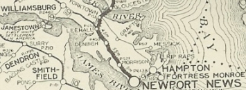
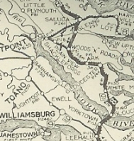
VA 9 Fort Monroe to Williamsburg VA 9 picked back up US 60 through Lightfoot, Norge and Toano. VA 9 then followed today's VA 30 and SR 748 to Barhamsville, then SR 633/627 Stage Rd through Slatersville, then VA 249 through New Kent to Carys Corner, then SR 609 to Tunstall Station, then SR 612 south to Quinton. VA 9 used VA 249 except Holly Hill Rd (no longer connects to) and SR 611 Quaker Rd. VA 9 used SR 674, then abandoned routing across I-64 to US 60 at the Henrico County line. VA 9 used the Old Williamsburg Rd which criss-crosses US 60 from Bottoms Bridge west to Sandston (cutoff by I-295 today). 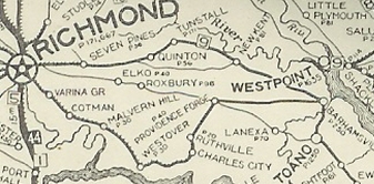
VA 9 via New Kent CH and Quinton VA 9 used US 60 to eastern Richmond, using Williamsburg Rd to National Cemetery Rd ro 36th St to Broad St. VA 9 used Adams St to Chamberlayne, then Norwood to Brook Rd north. It appears, VA 9 (with VA 1) used Hungary Rd to Purcell Rd, then north through Glen Allen onto Old Washington Hwy which turns into SR 626 at Hanover County. VA 9 used SR 626 to VA 54 (avoiding Ashland), then west (used SR 669-666 north of VA 54) to SR 686 Horseshoe Bridge Rd. VA 9 followed this to SR 785 west back to VA 54 at Negro Foot, where VA 1 split north. VA 9 continued on VA 54 to Montpelier, then US 33 to Cuckoo. VA 9 followed US 522 to Mineral, then VA 22 through Louisa, Trevillians, Boswell Tavern, Cobhams, Cismont to Shadwell. 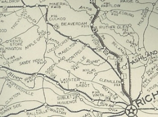
VA 9 Richmond towards Charlottesville VA 9 picked up US 250, then US 250 Business to Charlottesville. VA 9 used 4th and/or 5th Sts to move to Main St which it used west out of town along with SR 601 Old Ivy Rd. West of the US 29 Bypass, VA 9 used an abandoned alignment to the north side of 250 for much of the way to Ivy. VA 9 then used SR 738 and more abandoned routing north of US 250. VA 9 then used VA 240 through Crozet, and picked back up US 250. VA 9 used SR 797 through Yancey Mills (now cutoff by I-64). VA 9 used US 250, then SR 796 loop near VA 151. VA 9 then used SR 750 Old Turnpike Rd to ascend to Afton. VA 9 used VA 6 across the railroad, then SR 600 to complete the ascension of the mountain (no longer connects to US 250 near Afton Wayside). VA 9 used US 250's corridor to descend to Waynesboro (several old alignments are evident). VA 9 used a couple brief loops down to Waynesboro, then US 340 Main St through downtown. VA 9 picked back up US 250 then used SR 641 through Fishersville. 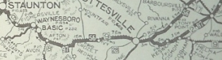
VA 9 Charlottesville to Staunton It appears VA 9 followed US 250 into Staunton but used Main to Central north back to current US 250. VA 9 used Old Churchville Rd out towards VA 262. VA 9 used US 250, then SR 840, then SR 721 south where VA 9 crossed the Middle River in line with SR 722 which VA 9 followed north back to 250 then west to Churchville. VA 9 followed US 250 to Monterey except it used SR 645 through McDowell. VA 9 used a brief loop west of Monterey, then according to the 1922 Auto Trails map used US 250 to West Virginia, following the older Staunton-Parkersburg Turnpike. 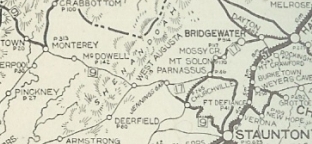
VA 9 Staunton to West Virginia In Dec 1921 (CTB), VA 9 was rerouted from Toano to Bottoms Bridge: West of VA 30, VA 9 used "old US 60" through Edwards Swamp; US 60 then SR 649 from Lanexa through Walkers. VA 9 may also have used SR 629 north of US 60 but definitely used it through Providence Forge. After more US 60, VA 9 used SR 631 through the Roxbury area (no longer exists west of VA 106). VA 9 then generally used US 60 to Bottoms Bridge. Some of the old route along the VA 249 corridor immediately became part of VA 9 SPUR #1. In 1923, VA 9 was renumbered as VA 39 except from West Virginia to Monterey became a secondary road, though later VA 835. VA 9 #2: The draft 1933 route log showed VA 9 running from North Carolina below South Boston north to Lynchburg (replacing VA 18); northwest to Lexington (replacing US 60 / VA 14); northwest through Warm Springs to West Virginia heading for Marlinton (replacing VA 805, VA 805-Y, VA 17, VA 804 and VA 804-Y). This was part of VDOH's plan to eliminate US 501 and move US 60 away from Lynchburg. However, AASHO talked Virginia into making VA 9 into US 501 from NC to Lexington and VDOH assigned VA 501 from Lexington to WV.
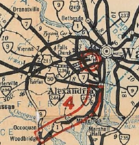
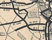
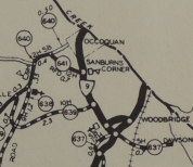
VA 9 proposed to run North Carolina to West Virginia 1933 draft route log VA 9 #3: Appeared in July 1933 as a renumbering of VA 25. Ran from US 1 Woodbridge through Occoquan to Fairfax, then Vienna to Chain Bridge, then around through Clarendon before ending at US 1 at Crystal City. In Oct 1940, VA 9 from Woodbridge to Chain Bridge became VA 123, while Chain Bridge to Crystal City became VA 120. Today, it is SR 906, SR 1203 through Occoquan, no crossing of the river, SR 722, some VA 123 with several Old Ox Road alignments up to Fairfax, then VA 123 to McLean, with SR 3563 Old Chain Bridge Rd, a bit of 123, more Old Chain Bridge Rd (SR 3547), VA 193, more VA 123, then VA 120 except it used Old Glebe Rd near Military Rd and Shirlington Rd south to 24th St east near I-395. The 1936 Official erroneously has VA 9 on East Glebe Rd instead of Glebe Rd. The state route moved to current Glebe Rd in 1931.
|
||||||||||||||
Previous: VA 8 |
Next: VA 10
Top | Virginia Hwy Index
Home
Page last modified 26 March 2022