< US 15 | Home | US 17-1 >
US 17 Business | US 17 ALT
| US 117 | US 217
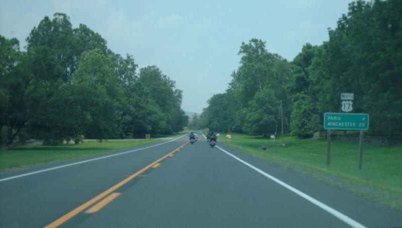
Photo: US 17 northbound near Sky Meadows State Park (photo by Mapmikey 7/12/08)
|
|
|
| ROUTE LOG |
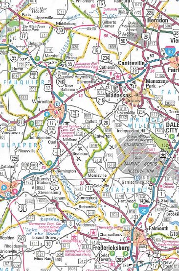
NC STATE LINE: 0 - 0 US 17 Bus: 10.29 - 10.29 VA 165: 3.86 - 14.15 VA 166: 0.94 - 15.09 VA 190: 1.60 - 16.69 I-464 Begin, VA 168 SB: 0.28 - 16.97 I-64 WB (exit 291): 0.46 - 16.60 I-64 EB (exit 296), US 17 Bus: 4.31 - 20.91 US 13, US 460: 0.90 - 21.81 VA 196: 1.00 - 22.81 Portsmouth-Chesapeake Line: 0.63 - 23.44 VA 239: 0.15 - 23.59 VA 141: 1.25 - 24.84 VA 337: 0.70 - 25.54 I-264 (exit 5): 0.62 - 26.16 VA 337 ALT: 0.35 - 26.51 US 58: 0.51 - 27.02 Chesapeake-Portsmouth Line: 3.94 - 30.96 Suffolk-Chesapeake Line: 1.25 - 32.21 VA 135: 0.20 - 32.41 I-664 (exit 9): 0.46 - 32.87 VA 164: 0.41 - 33.28 Isle of Wight-Suffolk Line: 6.58 - 39.86 US 258 SB, VA 32 SB: 2.43 - 42.29 Newport News-Isle of Wight Line: 6.81 - 49.10 US 60: 0.22 - 49.32 US 258 NB, VA 32 END, VA 143 SB: 0.56 - 49.88 VA 152: 1.31 - 51.19 VA 306: 1.69 - 52.88 VA 143 NB, VA 312: 1.12 - 54.00 I-64 (exit 258): 1.28 - 55.28 York-Newport News Line: 1.05 - 56.33 VA 171: 1.20 - 57.53 VA 134: 0.93 - 58.46 VA 173: 3.15 - 61.61 VA 105: 1.39 - 63.00 VA 238: 2.97 - 65.97 VA 90003, Colonial Pkwy: 0.28 - 66.25 Gloucester-York Line: 0.78 - 67.03 VA 216: 2.96 - 69.99 US 17 Bus: 9.05 - 79.04 US 17 Bus, VA 14 EB: 1.68 - 80.72 VA 14 WB: 7.83 - 88.55 VA 33 WB, VA 198: 4.77 - 93.32 Middlesex-Gloucester Line: 1.55 - 94.87 US 17 Bus, VA 33 EB: 0.81 - 95.68 US 17 Bus: 1.02 - 96.70 Essex-Middlesex Line: 12.63 - 109.33 US 360 WB: 13.34 - 122.67 US 360 EB: 2.44 - 125.11 Caroline-Essex Line: 20.66 - 145.77 US 301: 5.89 - 151.66 Spotsylvania-Caroline Line: 12.23 - 163.89 US 17 Bus, VA 2: 1.89 - 165.78 US 1 SB: 5.75 - 171.53 I-95 SB (exit 126), US 1 NB: 0.93 - 172.46 Fredericksburg-Spotsylvania Line: 2.81 - 175.27 VA 3: 0.89 - 176.16 Stafford-Fredericksburg Line: 2.29 - 178.45 I-95 NB (exit 133), US 17 Bus: 0.74 - 179.19 Fauquier-Stafford Line: 10.14 - 189.33 VA 28: 13.68 - 203.01 US 15 SB, US 29 SB: 3.24 - 206.25 US 15 Bus, US 17 Bus, US 29 Bus: 4.71 - 210.96 US 15 NB, US 15 Bus, US 29 NB, US 29 Bus: 2.44 - 213.40 US 17 Bus: 2.22 - 215.62 VA 245: 7.40 - 223.02 I-66 EB (exit 28), US 17 Bus: 2.02 - 225.04 US 17 Bus, VA 55 EB: 1.27 - 226.31 I-66 WB (exit 23): 3.42 - 229.73 VA 55 WB: 0.64 - 230.37 US 50 EB: 7.16 - 237.53 Clarke-Fauquier Line: 1.11 - 238.64 VA 255: 5.41 - 244.05 US 340: 2.83 - 246.88 Frederick-Clarke Line: 1.67 - 248.55 US 522 SB: 5.43 - 253.98 I-81 (exit 313): 0.16 - 254.14 Winchester-Frederick Line: 0 - 254.14 US 11, US 50 WB, US 522 NB: 0.95 - 255.09
|
Creation: Appeared in Virginia July 8, 1926 (AASHO), running from North Carolina to Portsmouth and Norfolk (replacing US 13); Newport News and Lee Hall; Yorktown, Gloucester and Tappahannock (replacing US 301) before ending at US 1/VA 31 (now US 1 Bus) Fredericksburg. In this routing, US 17 was added to:
| VA 40 from the North Carolina line to Portsmouth. VA 10 from Portsmouth to Norfolk VA 27 from Norfolk to Newport News VA 39 from Newport News to Lee Hall (duplexed with US 60 as well). VA 391 from Lees Hall to Yorktown VA 29 from Gloucester Point to Shackleford. VA 30 from Shackleford to Saluda VA 38 from Saluda to Fredericksburg
In May 1958 (AASHO), South Carolina tried to have US 17 south truncated to Norfolk with the route south to Florida becoming part of an extended US 5. No other states went along with this and it went nowhere. In June 1959 (CTB), US 17 was placed on Frederick Blvd in Portsmouth, replacing what had been designated US 17 ALT. The old route became US 17 Business. In Feb 1961 (CTB), US 17 was placed on new roadway to bypass Churchland, leaving behind SR 664 Churchland Blvd. In 1992, US 17 was rerouted away from Fenway Ave and Old GW Highway onto a new alignment over the railroad and to US 13-460. In Dec 2001, US 17 was rerouted away from Deep Creek, replacing VA 104 on Dominion Blvd to I-64, then using I-64 back over to US 17. The old route became US 17 Business (now parts of VA 141 and unnumbered streets). In 2006, US 17 was built onto a new alignment to the east of the route along the Dismal Swamp Canal from US 17 Bus south to the state line. The old routing became a bicycle path.
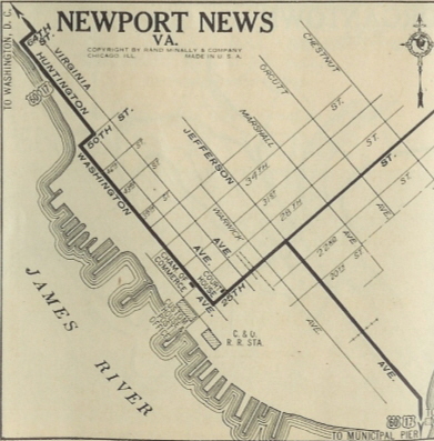
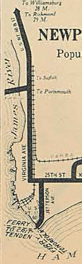
James River to Gloucester US 17 initially entered Newport News via ferry from Norfolk at the south end of Jefferson Ave, which is where US 60's east end was briefly. US 17-60 used Jefferson to 25th St west to Washington Ave then north to 50th St then east to Huntington Ave north to 64th St east to Virginia Ave (now Warwick Blvd). US 17-60 then followed today's US 60 to Nettles Rd which US 17 followed, then Mitchell Point Rd. US 17 may have used the now discontinuous Smucker Rd, but it definitely used Campbell Rd and Old Courthouse Way in the VA 173 area. US 17 then followed current US 60 to Lee Hall. US 17 left US 60 at Lee Hall via today's VA 238 and headed over to Yorktown. US 17 used SR 1020 into central Yorktown to the waterfront. US 17 then used a ferry to cross the York River to Gloucester Point. Here, US 17 picked up SR 1208 to today's 17. US 17 followed its current route to Gloucester except it used SR 1216 in Hayes and US 17 Business into Gloucester Adjustments: By 1929, US 17-60 was rerouted to use Warwick all the way down to 25th instead of zig-zagging around Newport News.
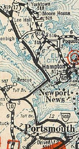
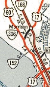
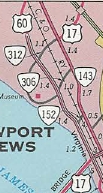
About 1932, US 17 was rerouted to enter Newport News at the James River Bridge where it does today. The old route to the Newport News Ferry area remained part of US 60. Also in 1932, US 17 was rerouted to go more directly to Yorktown from Newport News, by leaving US 60 at current VA 306 and using Harpersville Rd north to current US 17. In York County, US 17 used most of Theatre Rd to VA 134, then likely some of Cardinal Ln. After more current 17, the route used SR 621 Grafton Rd through Grafton. US 17 then followed today's US 17, then SR 704 into Yorktown. US 17 used Moore House Rd west, then Zweybrucken Rd north to Main St west to Ballard St north to the ferry. This reroute was an addition to VA 515 from US 60 to today's VA 134 and VA 514 from there to Yorktown. The old route remained US 60 out to Lee Hall and VA 514 from Lee Hall to Yorktown.
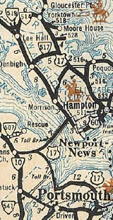
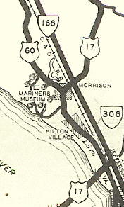
In Oct 1932 (CTB), the Commission granted a permit to the York River Bridge Corporation to apply for a permit and build a bridge. It appears the deal fell apart in 1933. Another attempt was made by the CTB to get a toll bridge going in 1939 but was also scuttled. Around 1940, US 17 was rerouted off Harpersville Rd between Warwick and Jefferson, leaving behind VA 306 #2. The new route replaced VA 306 #1 on Mercury Blvd from Warwick to Jefferson, then US 17 duplexed with VA 168 (now VA 143) up Jefferson to Harpersville Rd. On May 7, 1952 (per Nov 1952 CTB), US 17 was placed on a newly constructed bypass of Yorktown and Gloucester Point that included a new bridge over the York River (Coleman Bridge). This left behind SR 704 and a little VA 238 in York County and SR 1208 in Gloucester County. In 1951/1953, US 17 was removed from Theatre Rd at VA 134 and SR 621 Grafton. In August 1960 (CTB), US 17 was removed from Harpersville Rd (unnumbered since) and instead continued with VA 143 to the new J. Clyde Morris Blvd as it does today. In Feb 1964 (CTB), US 17 was removed from SR 1216 in Hayes.
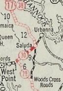
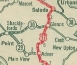
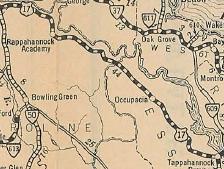
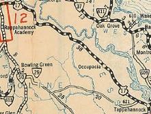
Gloucester to New Post US 17 initially used VA 14's route from Gloucester to Shacklefords, then east on SRs 601/679, then VA 33 to Glenns (except used SR 647 loop to Batts). US 17 then followed VA 33 from Glenns to Saluda, then picked up today's US 17 Bus and US 17 north from Saluda, then used SR 614 in the Warner area. After more 17, VA 38 used SR 695 in the Church View area. VA 38 the used US 17 to Jamaica, then SR 647. A bit more 17 was followed by SR 608 Glebe Landing Rd. In Essex County, US 17 followed SR 720 from Laneview to Montague; SR 602 from Montague to Oakley, then across US 17 and still on SR 602 looping over to Center Cross. After a bit of current 17, US 17 used SR 718 then crossed 17 onto another loop that is no longer a road; a little more 17 to Ozeana; then looped back and forth with current US 17 without using it all the way to SR 609 past Dunnsville (SR 1103/1102/1001 loops and some that are no longer roads); US 17 used a bit more of today's 17 then used an alignment slightly west to cross Piscataway Creek; then used "Old Seventeen" and SR 715 to Brays Fork. US 17 used US 17-360 into Tappahannock (except it used SR 698 loop and SR 1003 Essex St). US 17 then followed SR 657 west which no longer connects to SR 627. US 17 used SR 627 then SR 716 back to current US 17, then the SR 624 loop in Caret. US 17 used SR 624 to Lloyds, then SR 631 to Champlain, then an SR 11xx loop, then a little SR 633 over towards Occupacia. US 17 may have used SR 632 and SR 658 which no longer connects back to US 17 at Loretto. US 17 then used current US 17 to the Caroline County line except the bridge over Portobago Creek is to the north a little (but still there). US 17 seems to have followed today's 17 to Port Royal (using the NB alignment where the route splits). US 17 used the still visible old bridge to the north at Goldenvale Creek. US 17 followed current US 17 until past Rappahannock Academy then used SR 719 north to (no longer connects to) SR 614 then back to US 17 to New Post. Adjustments: In 1929, US 17 was placed on its current routing from Adner to Glenns, following the new VA 602. The old route to Shacklefords remained VA 29 and over to Glenns remained VA 30.
In late 1930, US 17 was placed on today's US 17's routing from Fredericksburg to Saluda.
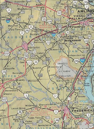
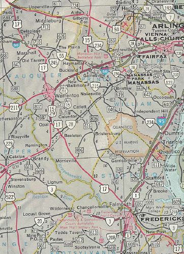
In Nov 1968 (CTB), an interchange at US 360 Brays Fork was proposed In June 1973 (AASHO), US 17 was placed on a new bypass to the west of Gloucester, leaving behind US 17 Business. In 1986, US 17 was placed on a new bypass to the west of Saluda, leaving behind US 17 Business. New Post to Winchester North of New Post, US 17 initially used SR 698 which no longer connects back to US 17 Bus but the two old bridges at Ruffins Pond are visible to the east of US 17 Bus. US 17 followed 17 Bus generally to SR 638, then likely used Old Airport Rd to head towards Fredericksburg, which used to connect with Dixon St. US 17 then turned onto Princess Anne St and the route ended at US 1/VA 31 (now US 1 Bus) National Rd (now Lafayette Blvd). Adjustments: In Dec 1934 (CTB), US 17 was moved to the current US 17 Bus north of New Post. The old route across Ruffins Pond became SR 698. In Dec 1963 (AASHO), US 17 was extended through Fredericksburg as a duplex with US 1 across The Rappahannock to Falmouth, then replaced VA 17 to Warrenton, Marshall and ending at US 11-50-522 Winchester. In Nov 1969 (CTB), US 17 was placed on a new Super-2 from New Post to US 1 (used existing SR 635 overpass of I-95 though), then used US 1 to I-95 which US 17 followed to US 17 north of the Rappahannock River. This left behind US 17 Business through Fredericksburg and Falmouth. In 1975, US 17 was rebuilt at Old Tavern to its current routing, replaced by a bit of VA 245 and SR 845. In June 1978 (AASHO), US 17 was placed on I-66 around Marshall, leaving behind US 17 Business and F-185. In 1985 or 1986, US 17 was put on a brief one-way split north of I-81. NB used the original route on Millwood Ave while SB began using Jubal Early Dr and Apple Blossom Dr. In 1998, US 17 was added to the existing US 15-29 bypass around Warrenton, then continued on new freeway bypass around the north side of town, leaving behind US 17 Business.
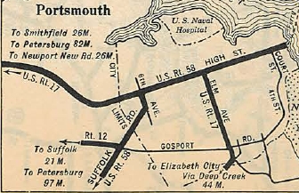
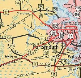
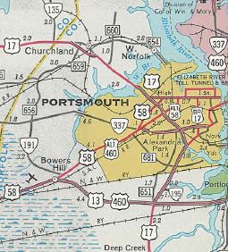
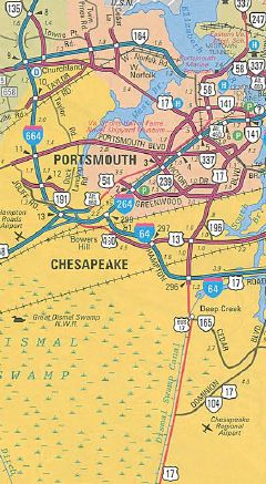
In early 2010, US 17 north was posted to extend along Cameron St in Winchester to end at Cork St (now posted as where US 50 west splits off). Improvements: Upon designation in 1926, US 17 was paved from NC line to Hayes In 1928, US 17 was paved from Hayes to Gloucester In 1931, the rest of US 17 was paved The First segment of US 17 to be multilaned was on its VA 168 duplex, by 1947. In 1951, US 17 was multilaned on High St in Portsmouth west out to Western Branch Elizabeth River In 1956, US 17 was multilaned from Victory Blvd to Western Branch of Deep Creek In 1957, US 17 was multilaned from the Deep Creek to Frederick Blvd In 1958, US 17 was multilaned from VA 196 to Victory Blvd; Gloucester Line to Saluda In 1959, US 17 was multilaned when placed on Frederick Blvd In 1960-61, US 17 was multilaned from US 60 to VA 143; Brays Fork to Tappahannock; Glenns to Middlesex Line; Churchland Bypass; US 13-460 to VA 196 has been erroneously shown as multilaned ever since 1961. In 1962, US 17 was multilaned from from Gloucester Point north to almost Hayes In 1964, US 17 was multilaned from VA 173 north a couple miles; Hayes to just short of Gloucester In 1965, US 17 was multilaned from VA 134 to VA 173; US 1 ALT to Falmouth In 1966, US 17 was widened from I-64 (N News) to VA 134; Opal to Warrenton; Paris to Ashby Gap In 1967, US 17 was multilaned into Gloucester. In 1968, US 17 was multilaned from Falmouth to I-95. In 1969, US 17 was multilaned from Churchland to the Nanesmond River; VA 143 to I-64; the remaining York County piece up to the Coleman Bridge; Tappahannock to Caret; its I-95 duplex In 1970, US 17 was widened from Nanesmond River to the James River except not across Chuckatuck Creek. In 1972, US 17 was widened from Caret to Champlain+; SR 723 to Winchester In 1973, US 17 was widended from Gloucester to Adner; Saluda to Church View; US 340 to SR 723 In 1974, US 17 was 4-laned from Champlain to Loretto; I-95 to Fauquier line In 1975, US 17 was widened from Churchview to Center Cross; Fauquier/Stafford line to Morrisville; Ashby Gap to Shenandoah River In 1976, US 17 was widened from Shenandoah River to US 340 In 1978, US 17 was multilaned from Adner to Glenns; Morrisville north 3 miles In 1979, US 17 was widened when added to I-66 around Marshall. In 1980, US 17 was widened on the new James River Bridge In 1981, US 17 was widened from Center Cross to Dunnsville; Morrisville +3 to Opal In 1986, US 17 was multilaned on the new Saluda Bypass In 1988, US 17 was multilaned on a bit more north of Dunnsville; SR 605 to VA 245 In 1990, US 17 was widened from Loretto to Caroline County; Warrenton to SR 605; VA 245 to I-66 In 1992, US 17 was 4-laned from I-64 to US 13-460; the Essex/Caroline line halfway to Port Royal In 1993 or 1994, US 17 was multilaned from Dunnsville+ to Brays Fork; the 3 miles north to Port Royal In 1996, US 17 was widened on the Coleman Bridge over the York River. In 1998, US 17 was fully widened in the Warrenton area when it was placed on its new bypass. In 2006, US 17 was multilaned from NC Line to US 17 Bus In 2008, US 17 was widened from its I-95 overpass in Massaponax to US 1. In 2016, US 17 was widened and converted to full freeway from I-64/464 southwest across the Elizabeth River to VA 165, eliminating the drawbridge and instead having a toll high rise bridge. There are significant segments of 6+ lanes on US 17 in Newport News on Jefferson Ave; also in Stafford County The remaining 2-lane segments are: I-64 to VA 196; Nanesmond River bridge; Chuckatuck Creek bridge; US 301 to US 1; I-66 to US 50 Posted: Fully posted; US 17 NB is not posted past I-81 Winchester cutouts replaced about 2010 and 1 cutout is still up in Tappahannock at SR 657 as of 2021. Yorktown cutouts disappeared in mid-2000s. In the early 90s there were error VA 17 shields on VA 134 NB. For many years there have been erroneous US 17 Bypass shields on the US 1 Fredericksburg bypass in the vicinity of VA 3. Multiplexes: I-464 (0.28 mi) I-464, VA 168 (0.46 mi) I-64 (4.31 mi) US 258, VA 32 (7.59 mi) VA 143 (4.12 mi) VA 14 (7.83 mi) VA 33 (2.86 mi) US 360 (2.44 mi) US 1 (0.93 mi) I-95 (6.73 mi) US 15, US 29 (7.15 mi) I-66 (1.72 mi) I-66, VA 55 (3.42 mi) VA 55 (0.64 mi) US 50 (16.45 mi) US 50, US 522 (1.11 mi) Legislative names: Ocean Highway, NC Line to US 13 except US 17 Bus (since 3/23/46); George Washington Highway, NC Line to Portsmouth except US 17 Bus (designation 2/27/24 predates US 17); Historyland Highways, NC Line to New Post except US 17 Bus in Chesapeake and Gloucester (since 5/26/53); George Washington Memorial Highway, Newport News to US 360 except US 17 bus Gloucester (since 3/10/28); Tidewater Trail, Gloucester Point to New Post except US 17 Bus Gloucester (since 2/26/58); James Madison Highway, from US 17 Bus Warrenton to VA 245 (designation 3/19/28 predates US 17); John S Mosby Highway, US 50 duplex (since 4/1/82) Harry Flood Byrd Bridge, Shenandoah River (designation 8/15/29 predates US 17); George P. Coleman Bridge, York River (since 8/23/49); Mills E. Godwin Jr Bridge, Nanesmond River, (since 2/19/81); Sidney Bertram Hazelwood Sr Bridge, Chuckatuck Creek (since 1/19/89); James River Bridge (since 1/15/87); James Vincent Morgan Bridges, Dragon Run (since 3/19/02) Other names: Dominion Blvd/Western Branch Blvd (Chesapeake); Frederick Blvd/High St/Western Branch Blvd (Portsmouth); Bridge Rd (Suffolk); Carrolton Blvd (Suffolk/Isle of Wight County); Mercury Blvd/Jefferson Ave/J Clyde Morris Blvd (Newport News); Tappahannock Blvd (US 360 duplex); Mills Dr (Spotsylvania Co); Warrenton Rd (Stafford Co); Marsh Rd (Fauquier Co south of Opal); Eastern Bypass (Warrenton); Winchester Rd (VA 245 to I-66); Millwood Pike (SR 723 to Winchester); Jubal Early Dr/Apple Blossom Dr/Millwood Ave (Winchestr). Scenic Byway: I-66 to US 50 (since 9/20/01) Old Truck Route: A Truck US 17 was posted in Warrenton, following the US 15-29 bypass around the east of town, then used US 29 Business west back to then-mainline US 17. Thus, trucks could not use what is now US 17 Business from its south end to where US 17 left US 29 Bus-US 211. I don't know how long that was in effect but it went away with the opening of the US 17 bypass. Comments: US 17's bridge over the York River is toll NB The James River Toll Rd encompassed the road from roughly Crittenden across the Nanesmond River, Chuckatuck Creek and the James River. It also included what is now US 258/VA 32 between VA 10 and US 17 but it carried no route designation until 1940 when VA 258 was routed over it. The Chuckatuck Bridge stopped being toll in 1959; Nanesmond River stopped being toll in 1963; The James River stopped being tolled in 1977. According to David Thompson, there was an old section of US 17 in southern Glocester Co. that was signed as "OLD 17" until the mid 80's, with an "OLD" sign above a US 17 shield. This was co-signed with SR 1216 through Hayes. Between Winchester and Warrenton is the only section of normally coastal US 17 which runs through the mountains. US 17 carries Tidewater Trail signage between Fredericksburg and Newport News. Parts were also signed as the Historyland Highway until 1996, along with VA 3. In Chesapeake US 17 runs through the Dismal Swamp, which until the 1980's required that headlights be used in the daytime, it was so dark and dense in there. Clear cutting on the east side of the highway solved this problem. US 17 could stand to be added to I-664 and I-64. The Isle of Wight/Suffolk/Chesapeake/Portsmouth routing could be made part of VA 10, while Portsmouth south to Deep Creek could become more VA 141. A bypass to the west of Tappahannock is in the long range planning. US 17 is extremely quiet from Saluda to Fredericksburg except for Tappahannock, with 60 mph speed limits from Port Royal to Saluda. The segment between I-66 and US 50 is restricted from through truck traffic (no posted TRUCK 17 though) and the speed limit has been permanently reduced to 45. The Oct 1978 CTB erroneously refers to US 17 Bypass of Fredericksburg as US 17-A. US 17 is erroneously identified as US 117 in the 1931 Portsmouth inset | |||||||||||||||||||||||||
Previous: US 15 |
Next: US 17-1
US 117 | US 217
Top | Virginia Hwy Index
Home
Page last modified 31 January 2022