< US 460 | Home | US 511 >
US 501 Business | US 501 ALT | US 501-Y
US 1 | US 301 | US 401
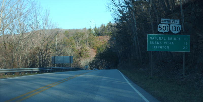
Photo: US 501 just after its old crossing of the James River Dam (photo by Mapmikey 1/20/07)
|
|
|
| ROUTE LOG |
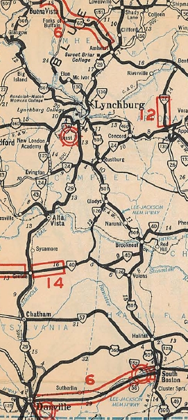
NC STATE LINE: 0 - 0 VA 96: 2.46 - 2.46 US 58, US 360: 8.48 - 10.94 VA 304: 0.62 - 11.56 VA 129: 0.22 - 11.78 VA 129: 2.84 - 14.62 VA 349: 2.27 - 16.89 VA 360 WB: 0.03 - 16.92 VA 360 EB: 0.78 - 17.70 VA 40 WB: 14.45 - 32.15 Campbell-Halifax Line: 0.97 - 33.12 VA 40 EB: 0.85 - 33.97 VA 24 WB: 19.52 - 53.49 VA 24 EB: 0.92 - 54.41 Lynchburg-Campbell Line: 6.97 - 61.38 US 29 NB, US 460 EB, US 460 Bus, US 501 Bus: 1.08 - 62.46 US 29 SB, US 460 WB: 1.91 - 63.37 VA 128 EB: 0.50 - 63.87 US 29 Bus NB, VA 128 WB: 0.43 - 64.30 US 29 Bus SB, VA 163: 0.33 - 64.63 US 460 Bus: 1.37 - 66.00 US 221: 2.45 - 68.45 US 501 Bus: 3.40 - 71.85 Bedford-Lynchburg Line: 1.80 - 73.65 VA 122: 9.96 - 83.61 Blue Ridge Pkwy: 1.45 - 85.06 Amherst-Bedford Line: 2.13 - 87.19 VA 130 EB: 0.14 - 87.33 Rockbridge-Amherst Line: 4.69 - 92.02 VA 130 WB: 2.43 - 94.45 Buena Vista-Rockbridge Line: 6.34 - 100.79 US 501 Bus: 2.06 - 102.85 US 501 Bus: 0.60 - 103.45 US 60: 0.51 - 103.96
|
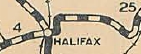
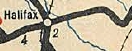
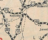
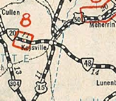
Creation: Conceived in 1925 and appeared in late 1926 as an original US Highway, following VA 18 from the North Carolina line below Cluster Springs to Halifax, VA 12 to Wylliesburg, VA 32 to Keysville, and VA 20 to end at US 60/VA 10 (now SR 716) Burkeville.
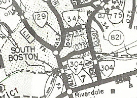
| Here is a more detailed look at US 501's routing: US 501 used SR 866 Woody Loop and SR 865 Whitt Loop near the state line, then followed its current path to South Boston, then used the NB split, then VA 129 through town and up to Loves Shop. US 501 then picked up its current route to Halifax.
Also in 1931, US 501 was rerouted to use today's US 360 directly northeast of Keysville to Simplicity instead of US 15/SR 654.
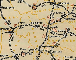
The draft 1933 route log showed US 501 decommissioned in its entirety within Virginia. North Carolina to Halifax was to become part of VA 9 and Halifax to Burkeville would've become part of VA 40. In May 1933 (AASHO), US 501 was retained and radically altered at AASHO's suggestion. Everything from Halifax northeast to Burkevile was renumbered as US 360 (Virginia had requested US 33).
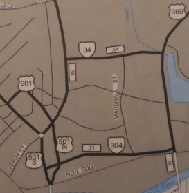
Instead, US 501 was sent north replacing VA 18 to Lynchburg, then replacing US 60/VA 14 up to its new endpoint - US 11 in Lexington. More specifically, US 501 crossed the Bannister River slightly east of today's bridge, picking up Sedge Hill Trail, then modern 501, then abandoned routing, then SR 615 Dudley Rd and more 501. US 501 used SR 610 Murphy Grove Rd and SR 643 Cedar Fork Rd. After some modern 501, the route used SR 643 McKendree Church Rd and SR 755 Bradley Rd. US 501 likely used Parsonage Rd and Millstone Church Trail Loops.
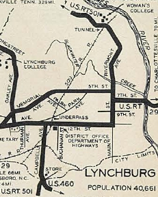
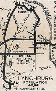
In 1936, US 501 was given its first bypass of Lynchburg, using today's US 501 Business along Langhorne Rd. The old route through downtown Lynchburg became US 501 ALT.
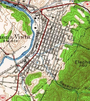
In Feb 1937 (CTB), US 501 was removed from SRs 894/898 in Rustburg. In March 1937 (CTB), US 501 was removed from SRs 615/610/643 north of Halifax. In Dec 1938 (CTB), US 501 was rerouted in Buena Vista, removing it from Orchard, Chestnut, and Factory Sts to instead use Beech/Park/Magnolia. Back then, the intersection with relocated US 60 had a Y setup with the western leg being US 501Y.
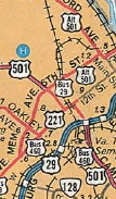
In Aug 1939 (CTB), US 60-501 was moved from Washington St to Nelson St east of US 11 in Lexington, moving US 501's endpoint south 1 block. In Nov 1944 (AASHO), US 501 north was truncated to US 60 Buena Vista, leaving behind US 60. It is unclear if US 501 was posted with US 60 to Lexington. No map I have seen ever showed the extension, though starting with the 1941 Route Log it was said to end in Lexington instead of Buena Vista. In Dec 1947 (CTB), US 501 was removed from SRs 1029/1030 north of Rustburg. By 1958, US 501 was removed from SRs 865/866 near the NC Line. In 1958, US 501 was given its current Bannister River routing. In May 1963 (CTB), US 501 was given its current alignments south of Volens. In Jan 1967 (CTB), US 501 was given its bypass of Naruna. In Feb 1969 (CTB), US 501 was rerouted in Lynchburg to use Kemper St north of Edmond. Maps show a one-way split alignment between 12th and today's US 29 Bus, most like involving Buchanan St and either 14th or 15th. In March 1972 (CTB), US 501 was given its one-way split routing through South Boston.
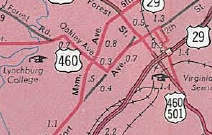
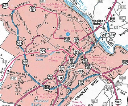
In 1981, US 501 (with US 221 and US 460 Bus) was removed from a one-way split between 12th St and US 29 Lynchburg Expressway. In Oct 1989 (AASHTO), US 501 was given its current freeway routing around the west of Lynchburg, replacing what had been part of VA 291. Mainline US 501 via Langhorne became US 501 Business.
About 2004, US 501 was placed on what had been US 501 ALT through Buena Vista, leaving behind US 501 Business and some unposted routing. In Nov 2016, US 501 was put on a new bridge over the James River about 3/4 mile south of the original location. Improvements: Upon designation in 1926, US 501 was fully paved only from South Boston to Halifax. The 1931 Official shows no other segments paved, while the 1932 Official shows the original US 501 routing to Burkeville fully paved. The 1933 reroute to Buena Vista was already paved. The First segments of US 501 to be 4-laned were in 1952, from South Boston to Halifax and also on its US 460 duplex east of Lynchburg. By 1961, US 501 was multilaned on a short segment north of 8th St in Lynchburg. In 1986, US 501 was multilaned from US 460 south to the Lynchburg-Campbell line. In 1988, US 501 was multilaned a couple more miles further south into Campbell County.Templeton. In 1990, US 501 was multilaned on its freeway bypass of Lynchburg around to about US 221, plus at the Wigginton Rd interchange. In 1992, US 501 was multilaned from VA 96 to about Cluster Springs; also widened further south to nearly Rustburg. In 1993 or 1994, US 501 was multilaned from Cluster Springs to South Boston. In 1997 or 1998, US 501 was multilaned from the NC Line to VA 96. Posted: Fully posted The last known US 501 cutout was facing the wrong way onthe SB alignment of the route through South Boston, which was removed in the early 2000s. Multiplexes: VA 360 (0.78 mi) VA 40 (1.82 mi) VA 24 (0.92 mi) US 29, US 460 (1.91 mi) VA 128 (0.43 mi) US 29 Bus (0.33 mi) VA 130 (7.12 mi) Legislative names: Lee-Jackson Highway, from NC Line to VA 130 Glasgow (10-25-23 designation predates US 501; Huell W. Matthews Highway, NC Line to US 58 (3-3-92); Louis P. Bailey Memorial Highway from NCL Halifax to Campbell County line (4-4-90) Howard P. Anderson Bridge over Staunton River (3-3-92); Tucker C. Watkins, Jr Memorial Bridge over Dan River (2-15-68 designation); Other names: [Main St SB/Broad St NB]/Wilborn Ave/Halifax Rd (South Boston); Main St (Halifax); Lusardi Dr/Lynchburg Ave (Brookneal); Brookneal Hwy (Campbell Co s of VA 24); Campbell Hwy (Campbell Co n of VA 24); Campbell Ave/Candler Mtn Rd/Lynchburg Expwy/Boonsboro Rd (Lynchburg); Glasgow Hwy (Rockbridge Co); Magnolia Ave/Beech Ave (Buena Vista) Scenic Byway: No segments Truck Route: A very well-posted truck route exists for South Boston, using US 360 and Hamilton Blvd. It goes back to at least the 1990s. Comments: US 501 had a related state route extension, VA 501, which used the route of current VA 39 Following US 501 BYPASS through Lynchburg requires 3 different interchange ramps, as well as two at-grade turns. From Dave: On one random road trip in 1996, I crossed the VA/NC border at various points near US 501 to see how they marked the state line on back roads. VA didn't mark it real well, but NC went through the whole Welcome To/State Speed Limit/Buckle Your Seatbelts spiel on one back road. On a more minor back road that was unpaved, NC still had a state line sign, but managed to do without the other signs. | ||||||||||||||||||||||

Previous: US 460 |
Next: US 501 ALT | US 501 Bus | US 501-Y | US 511
US 1 | US 301 | US 401
Top | Virginia Hwy Index
Home
Page last modified 18 March 2022