|
|
|
|
ROUTE LOG
US 460: 0 - 0
VA 412: 2.75 - 2.75
US 460: 3.58 - 6.33
VA 114: 2.02 - 8.35
US 460: 0.66 - 9.01
VA 111: 0.29 - 9.30
US 11 SB: 1.66 - 10.96
VA 111: 1.21 - 12.17
US 460: 0.86 - 13.03
I-81 (exit 118), US 11 NB, US 460: 1.15 - 14.18
|
|
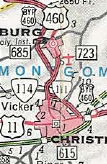
Creation: US 460 Business for Blacksburg and Christiansburg started out as separate business routes for each town, Christiansburg appeared in Oct 1966 (CTB) and Blacksburg in Feb 1969 (CTB) when US 460 was placed on new freeway east of Christiansburg and expressway west of Blacksburg
Adjustments:
About 2001, US 460 Business was extended east along US 11 to its current end when US 460 was routed across US 11 to I-81 directly.
In 2002, the Blacksburg US 460 Business was extended south to VA 114.
In 2003, the two business routes were connected when the freeway connecting the two bypasses was completed.
Improvements: Paved upon inception; All multilaned except the northern 2 miles and a small section south of VA 412, since its inception.
Posted: Fully posted; several cutouts remained in Christiansburg until about 2013 and only 1 remains as of 2022.
US 460 Business is not well posted in Blacksburg except at its endpoints and not at all at VA 412.
Multiplexes: US 11 (3.22 mi)
Legislative names: Lee Highway, US 11 duplex (designation 3/20/22 predates US 460)
Other names: Main St (Blacksburg); N. Franklin St/E Main St/Roanoke St (Christiansburg)
Scenic Byway: no segments
Comment: US 460 Business is a very busy corridor.
Separate Business routes
1970 Official
|
Connected Business routes
2004 Official
|
|
|
|
|
|
ROUTE LOG
US 460: 0 - 0
VA 47: 0.88 - 0.88
Prince Edward-Appomattox Line: 0.25 - 1.13
US 460: 1.64 - 2.77
|
|
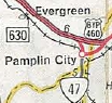
Creation: US 460 Business for Pamplin C.H. appeared in Oct 1969 (CTB) when US 460 was placed on new expressway north of town.
Adjustments: None
Improvements: Paved upon inception; no multilane segments
Posted: Fully posted;
Multiplexes: None
Legislative names: Colonial Trail (desgination 3/24/30 predates US 460)
Other names: Pamplin Rd
Scenic Byway: no segments
Comment: US 460 Business follows original VA 10 through Pamplin.
|
1970 Official
|

   |
From:   Burkeville (Nottoway County)
To:
Burkeville (Nottoway County)
Total Length: 1.13 miles
|
|
|
|
|
ROUTE LOG
US 360, US 460, US 460 Bus BEGIN: 0 - 0
US 360, US 460, US 460 Bus END: 1.13 - 1.13
|
|
Creation: Designated November 1969 (CTB) as a renumbering of mainline US 360-460 through Burkeville
Adjustments: None
Improvements: Paved upon inception; no multilane segments
Posted: Fully posted;
Multiplexes: US 360 Bus (entire route)
Legislative names: Patrick Henry Highway, entire route (2/18/28 designation predates US 460);
Other names: None
Scenic Byway: no segments
Comment:Burkeville is pretty sleepy for a town shown on a sign in Reedville, 136 miles away!
|
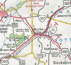
US 360 bypasses Burkeville
US 360-460 Business in Burkeville
1970 Official |
|
|
|
|
ROUTE LOG
US 221, US 221 Bus BEGIN, US 460: 0 - 0
VA 122 Bus SB: 1.08 - 1.08
US 221 Bus NB, VA 43 NB, VA 122 Bus NB: 0.19 - 1.27
VA 43 SB: 0.08 - 1.27
US 221 NB, VA 122 NB: 1.10 - 2.37
US 221 SB, US 460, VA 122 SB: 0.08 - 2.45
|
|
Creation: US 460 Business for Bedford appeared in Dec 1970 (CTB) when US 460 was placed on the existing VA 297 bypass of Bedford. The western half had been US 460; both halves had been VA 297 Bus.
Adjustments: None
Improvements: Paved upon inception; western half multilaned upon inception.
Posted: Fully posted; Cutouts removed in early 90s.
Multiplexes: US 221 Bus (entrie length)
US 221 Bus, VA 122 (0.19 mi)
VA 43 (0.08 mi)
US 221, VA 122 (0.08 mi)
Legislative names: Colonial Trail, US 221 duplex (designation 3/24/30 predates US 460)
Other names: Main St.
Scenic Byway: no segments
Comment: The west half of US 460 Business follows original VA 10.
|
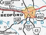
VA 460 error leftover from VA 297
1975 Official |
|
|
|
|
ROUTE LOG
US 460, VA 67 SB: 0 - 0
VA 67 NB: 0.85 - 0.85
US 460: 1.14 - 1.99
US 460: 2.25 - 4.24
|
|
Creation: US 460 Business for Richlands and Cedar Bluff appeared in June 1973 (AASHO) when US 460 was placed on new freeway north of Richlands and south of Cedar Bluff.
Adjustments: None
Improvements: Paved upon inception; no multilane segments
Posted: Fully posted
Multiplexes: VA 67 (0.85 mi)
Legislative names: None
Other names: Front St (EB)/2nd St (WB)
Scenic Byway: no segments
Comment: US 460 Business splits onto one-way routings in central Richlands, which based on the age of the signage happened while still mainline US 460.
|
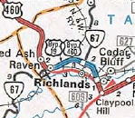
Bonus US 19 error!
1976 Official
|
|
|
|
|
ROUTE LOG
US 13, US 58, US 460, VA 32: 0 - 0
VA 10 NB, VA 32 Bus NB: 1.11 - 1.11
US 13 Bus SB, US 58 Bus WB, VA 10 SB, VA 32 Bus SB: 1.58 - 2.69
VA 337: 2.48 - 5.17
US 13, US 58, US 460: 1.22 - 6.29
|
|
Creation: US 460 Business for Suffolk appeared in Aug 1973 (CTB) when US 460 was placed on new freeway north of town.
Adjustments: None
Improvements: Paved upon inception; Entire route was multilaned already upon designation
Posted: Fully posted; Some postings are on LGS.
Multiplexes: VA 10, VA 32 Bus (1.11 mi)
US 13 Bus, US 58 Bus (2.82 mi)
Legislative names: None
Other names: Main St/Constance Rd/Portsmouth Blvd
Scenic Byway: no segments
Comment: US 460 Business appeared before other Suffolk Business routes because the freeway didn't extend west of US 460 at first.
|
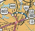
US 460 with the Suffolk bypass to itself
1974 Official
|
|
|
|
|
ROUTE LOG
US 19, US 460: 0 - 0
VA 91: 1.58 - 1.58
VA 16 SB: 0.27 - 1.85
VA 16 ALT: 1.75 - 3.60
VA 16 NB: 1.25 - 4.85
VA 61: 1.65 - 6.50
US 19, US 460: 1.58 - 8.08
|
|
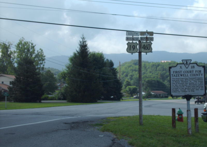
Creation: US 460 Business for Tazewell appeared in 1974 when US 19-460 was placed on new freeway north of town. This was approved by AASHO in May 1970.
Adjustments: None
Improvements: Paved upon inception; no multilane segments
Posted: Fully posted; numerous cutouts remain within Tazewell proper as of 2021.
Multiplexes: US 19 (entrie length)
Us 19, VA 16 (3.00 mi)
Legislative names: Trail of the Lonesome Pine, entire route (designation 3/24/30 predates US 460)
Other names: Main St/Fincastle Tpk
Scenic Byway: Entire route (since 3/8/93)
Comment: US 460 Business follows much of the original VA 11 through Tazewell.
|
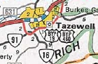
1976 Official
|
|
|
|
|
ROUTE LOG
US 460: 0 - 0
VA 40 WB: 6.48 - 6.48
VA 40 EB: 0.59 - 7.07
US 460: 3.17 - 10.14
|
|
Creation: US 460 Business for Nottoway CH and Blackstone appeared in 1976 when US 460 was placed on new expressway north of town. AASHO approved this in May 1970.
Adjustments: None
Improvements: Paved upon inception; no multilane segments
Posted: Fully posted; In Blackstone there were a couple older unisigns that remained until about 2008. VA 460 Bus shields on VA 40 EB existed in late 2000s.
Multiplexes: VA 40 (0.59 mi)
Legislative names: Colonial Trail, entire route (designation 3/24/30 predates US 460)
Other names: Old Nottoway Hwy, Church St/Main St (Blackstone)
Scenic Byway: no segments
Comment: Blackstone is a real place with an actual downtown area.
|
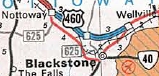
1976 Official
|
|
|
|
|
ROUTE LOG
US 460: 0 - 0
Lynchburg-Campbell Line: 3.36 - 3.36
US 501: 2.13 - 5.49
VA 163 SB: 1.15 - 6.64
VA 163 NB: 1.19 - 7.83
US 221 SB: 0.57 - 8.40
US 501 Bus NB: 0.67 - 9.07
US 29 Bus, US 221 END: 0.59 - 9.63
VA 128: 1.22 - 10.85
US 29, US 460, US 501, US 501 Bus END: 0.71 - 11.56
|
|
Creation: US 460 Business for Lynchburg appeared in July 1976 (AASHTO) as a renumbering of VA 126, a duplex with US 29 Bus, new primary routing on Fort Ave, and a duplex with US 221 and US 501.
Adjustments: In 1981, US 460 Bus (with US 221 and US 501) was removed from a one-way split between 12th St and US 29 Lynchburg Expressway. WB traffic had been using Buchanan and either 14th or 15th St.
In Dec 1988 (AASHTO), US 460 Bus was extended southwest, replacing mainline US 460 which was moved to the existing VA 224 freeway.
Improvements: Paved upon inception; Entire route was multilaned already upon designation
Posted: Fully posted, almost exclusively as unisigns within Lynchburg.
Multiplexes: VA 163 (1.19 mi)
US 221 (0.67 mi)
US 221, US 501 Bus (0.59 mi)
US 501 Bus (1.93 mi)
Legislative names: Colonial Trail, US 221/US 501 Bus duplexes (designation 3/24/30 predates US 460)
Other names: Timberlake Rd, Fort Ave, 12th St, Kemper St, Campbell Ave
Scenic Byway: no segments
Comment: Southwest of US 221 had never been part of US 460.
Original US 460 Bus in Lynchburg
1977 Official
|
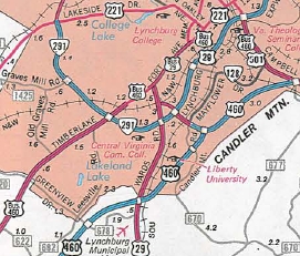
Expanded US 460 Business
1989 Official
|
|
|
|
|
|
ROUTE LOG
US 15 SB, US 460: 0 - 0
US 15 NB, US 15 Bus BEGIN: 0.24 - 0.24
US 15 Bus SB, VA 45: 4.12 - 4.36
US 460: 2.77 - 7.13
|
|
Creation: US 460 Business for Farmville appeared in Aug 1977 (CTB) when the eastern half of the Farmville Bypass was completed.
Adjustments: None
Improvements: Paved upon inception; brief multilaning near WCL of Farmville.
Posted: Fully posted, cutouts removed in mid-90s.
Multiplexes: US 15 (0.24 mi)
US 15 Bus (4.12 mi)
Legislative names: Colonial Trail (designation 3/24/30 predates US 460)
Other names: 3rd St (Farmville)
Scenic Byway: no segments
Comment: The western half of US 460 Business does not follow original VA 10, which used SR 695.
|
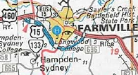
1978 Official
|
|
|
|
|
ROUTE LOG
US 460: 0 - 0
VA 100 NB: 0.60 - 0.60
VA 100 SB: 0.38 - 0.98
US 460: 2.48 - 3.46
|
|
Creation: US 460 Business for Pearisburg appeared in June 1981 (AASHTO) when US 460 was placed on new freeway north of town. It followed VA 100 west out of town to where it kisses US 460 today.
Adjustments: In November 1982 (AASHTO), US 460 Business was rerouted to leave VA 100 just west of town and follow the freeway stub north back to US 460. The old routing west remains part of VA 100.
Improvements: Paved upon inception; Multilane east of VA 100 since inception.
Posted: Fully posted; 2 cutout shield sets remain as of 2021, per HB Elkins.
Multiplexes: VA 100 (0.38 mi)
Legislative names: Wysor Highway, VA 100 duplex (since 3/24/55)
Other names: Main St, Wenonah Ave
Scenic Byway: no segments
Comment: None
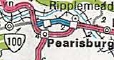
US 460 Business original routing
1982 Official
|
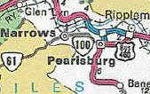
US 460 Business west end moved further east
1984 Official
|
|
|
|
|
|
ROUTE LOG
I-85 SB (exit 61): 0 - 0
US 1 SB: 0.17 - 0.17
VA 142: 1.55 - 1.72
I-85 (exit 63), US 460: 0.25 - 1.97
VA 319: 0.60 - 2.57
VA 226: 0.62 - 3.19
VA 357: 0.25 - 3.44
VA 319: 0.08 - 3.52
Petersburg-Dinwiddie Line: 0.12 - 3.64
VA 36 WB: 2.38 - 6.02
US 301 ALT SB: 0.20 - 6.22
US 1 NB, US 301 ALT NB: 0.20 - 6.42
I-95 (exit 52): 0.20 - 6.62
US 301 NB, VA 36 EB: 0.30 - 6.92
US 301 SB: 1.07 - 7.99
VA 109: 0.82 - 8.81
US 460, VA 106: 2.16 - 10.97
|
|
Creation: US 460 Business for Petersburg appeared in Dec 1988 (AASHTO) when US 460 was placed on I-85 and I-95 in the area. Originally, the US 460 Bus eastern end was just southeast of the US 301 split, very close to I-95.
Adjustments: About 2007, US 460 Business was extended southeast to VA 106 when US 460 was re-routed to use Wagner Rd.
Improvements: Paved upon inception; US 460 Business was multilaned between I-85 and US 1 and also from the one-way splits near WCL Petersburg east back to US 460.
The Winfield Rd portion of US 460 Business is now a 2-lane road on the old 4-lane undivided pavement. I do not know if this regression came before or after the 460 Business designation.
Posted: Fully posted; There is an erroneous US 460 ALT shield EB where it transitions from VA 36 to US 301
Multiplexes: US 1 (6.02 mi)
US 1, VA 36 (0.20 mi)
US 1, US 301 ALT, VA 36 (0.20 mi)
VA 36 (0.5 mi)
US 301 (1.07 mi)
Legislative names: Colonial Trail (designation 3/24/30 predates US 460); Jefferson Davis Hwy, US 1 duplex (designation 3/17/22 predates US 460); Blue Star Memorial Hwy, US 301 duplex (since 2/24/48)
Other names: Airport St (I-85 to US 1); Boydton Plank Rd (Dinwiddie County); Washington St (WB)/Wythe St (EB), Crater Rd, Winfield Rd (WB only), County Dr
Scenic Byway: no segments
Comment: The US 460 Bus EB route cannot turn left onto Winfield Rd from US 301 SB and instead must continue to I-95 SB ramps which has a ramp to what had been mainline US 460's route off I-95 onto County Dr. US 460 WB is much more direct to make this connection.
|
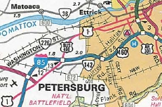
1991 Official
|
|
|
|
|
ROUTE LOG
US 460, VA 24, VA 26: 0 - 0
VA 131 NB: 0.28 - 0.28
VA 131 SB: 0.07 - 0.35
VA 131: 0.71 - 1.06
US 460: 1.05 - 2.11
|
|
Creation: US 460 Business for Appomattox appeared in Oct 1993 (AASHTO) when US 460 was placed on new freeway north of town.
Adjustments: None
Improvements: Paved upon inception; multilane on the western end only
Posted: Fully posted;
Multiplexes: VA 131 (0.07 mi)
Legislative names: Colonial Trail (designation 3/24/30 predates US 460)
Other names: Pamplin Rd
Scenic Byway: no segments
Comment: US 460 Business has the distinction of 3 different intersections involving VA 131.
|

1994 Official
|
|
|
|
|
|
ROUTE LOG
US 460, VA 83: 0 - 0
US 460, VA 83: 0.80 - 0.80
|
|
Creation: US 460 Business for Grundy appeared around 2014 when US 460/VA 83 was placed on newly constructed roadway a little southeast of Grundy. The Busines route centers around SR 615 Levisa St.
Adjustments: None
Improvements: Paved upon inception
Posted: Fully posted;
Multiplexes: None
Legislative names: None
Other names: unknown
Scenic Byway: no segments
Comment: US 460 Business serves most of the chain businesses associated with Grundy.
|
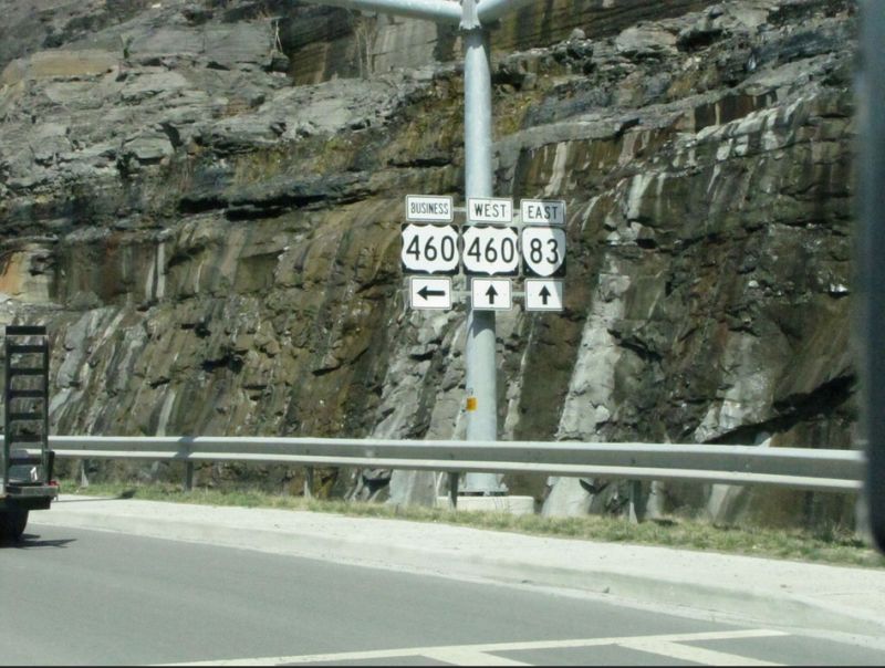
photo by H.B. Elkins, March 2014
|
|
Previous: US 441 |
Next: US 501
US 460 | US 460 ALT | US 460-Y
US 60 | US 360
Top | Virginia Hwy Index
Home
Page last modified
17 March 2022
| | | | | | | | | | | |