< VA 23 | Home | VA 25 >
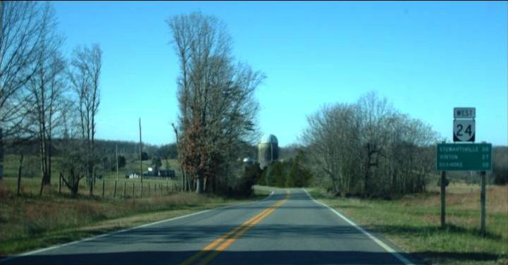
Photo: VA 24 in eastern Bedford County (photo by Mapmikey 12/11/09)
|
.
|
|
| ROUTE LOG |
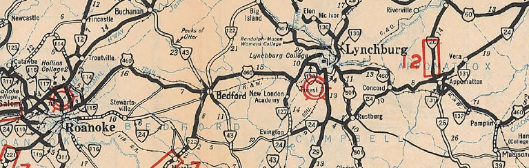
VA 116: 0 - 0 I-581 (exit 6), US 220: 0.17 - 0.17 Roanoke County-Roanoke City Line: 1.81 - 1.98 Blue Ridge Pkwy: 3.23 - 5.21 Bedford-Roanoke Line: 0.25 - 5.46 VA 122: 17.43 - 22.89 VA 43 NB: 5.51 - 28.40 VA 43 SB: 2.58 - 30.98 Campbell-Bedford Line: 7.59 - 38.57 US 29: 8.74 - 46.31 US 501 SB: 4.32 - 50.63 US 501 NB: 0.92 - 51.55 US 460 WB: 9.54 - 61.09 Appomattox-Bedford Line: 0.11 - 61.20 US 460 Bus, VA 26: 7.79 - 68.99 US 460 EB, VA 131: 0.72 - 69.71 Buckingham-Appomattox Line: 10.15 - 79.86 US 60: 8.71 - 88.57
|
Creation: Appeared July 1933 as a renumbering of VA 207 from VA 117 near Salem east to the SR 801-806 jct southeast of Chamblissburg. A second piece replaced VA 325 from the Bedford-Campbell line to Evington, then replaced some of VA 43 to Concord, then as a suplex with US 460 replacing part of US 60 and VA 10 to Appomattox, then replacing VA 308 and VA 306 over to US 60 Mt. Rush. This is the 2nd VA 24.
|
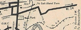
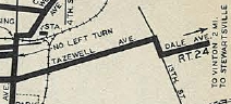
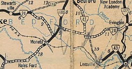
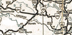
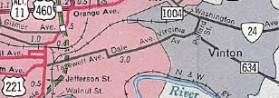
 VA 24 with gap in Bedford County 1933 Official Adjustments:In Aug 1933 (CTB), the eastern piece of VA 24 was extended west into Bedford County, ending at the VA 43 NB split. In 1934, VA 24 moved from 11th St to 13th St to get from Tazewell Ave to Dale Ave in eastern Roanoke.
In Oct 1935 (CTB), the western piece of VA 24 was extended east 7.08 miles. In Sept 1937 (CTB), the remaining 1.39 gap between the pieces west of VA 43 was put into the state highway system. In March 1938 (CTB), VA 24 was removed from Preston Rd/Fairmont Dr in eastern Vinton. In July 1939 (CTB), VA 24 was removed from SR 747 Joppa Mill Rd and SR 801 Flint Hill Rd east of Stewartsville. In Nov 1940 (CTB), VA 24 was given a bypass of Appomattox Courthouse National Historic Park, leaving behind what are now non-drivable alleys through the park. In June 1942 (CTB), VA 24 was placed on new alignment between SR 801 Flint Hill Rd and VA 122, leaving behind SR 801 Stony Fork Rd and 2.4 miles of VA 122.
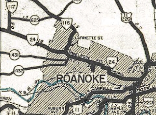
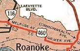
On 1/1/1947 (per Virginia Hwy Bulletin), VA 24 west was truncated to Williamson/Franklin/Tazewell intersection. Salem to Roanoke became part of US 460 while the route through Roanoke remained part of VA 116. Note that VA 24 had used 11th St and Gilmer Ave instead of Melrose all the way from Salem to Roanoke.
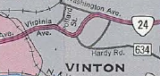
By 1958, VA 24 was placed on its current routing in Concord when US 460 was removed from SR 800. Per official maps, in 1969, VA 24 was removed from Tazewell Ave/13th St/bit of Dale Ave and placed on its current one-way splits east of I-581 (Bullitt Ave EB and Jamison Ave WB) and given its current west end at VA 116 via Elm Ave. In Feb 1971 (CTB), VA 24 was given its bypass of Vinton, leaving behind Washington Ave and Pollard St.
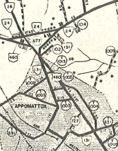
In June 1972 (CTB), VA 24 was placed on new alignment west of Stewartsville leaving behind SR 886 Drewrys Hill Rd. In May 1979 (CTB), VA 24 was removed from SR 738 Anstey Rd and a small US 29 duplex south of Lynchburg. Around 1994, VA 24 was moved onto the new US 460 bypass of Appomattox, leaving behind SR 748 Union Blvd and an extended VA 131.
Improvements: Upon designation, VA 24 was paved Salem to Vinton; VA 122 duplex; Evington to Mt. Rush In 1937, VA 24 was paved from Vinton to Stewartsville. In 1938, VA 24 was paved from Stewartsville to SR 746. In 1939, VA 24 was paved on its VA 43 duplex. In 1942, VA 24 was paved from SR 746 to VA 122. In 1949, VA 24 was paved from VA 122 to Evington, making VA 24 fully paved. The first piece of VA 24 to be multilaned was in 1965 with US 460 from east of Concord to Appomattox In 1966, VA 24 was widened at Concord with US 460. In 1968, VA 24 was multilaned from Vinton to just into Bedford County. In 1969, VA 24 was multilaned from I-581 east to Pollard Ave in Vinton. In 1970, VA 24 was multilaned along most of its Washington Ave route in Vinton. In 1971, VA 24 was multilaned from VA 116 to I-581 and on its new Vinton bypass. In 1972, VA 24 was multilaned east to Stewartsville. Posted: Fully posted; Last known cutout is EB at the eastern end of the Vinton Bypass, still shown in GMSV from July 2012. Embossed cutout in Roanoke lasted to at least 1991. Multiplexes: VA 43 (2.58 mi) US 501 (0.92 mi) US 460 (8.62 mi) Legislative names: Hal Flood Highway, US 460 to US 60 (since 3-1-54) Other names: Elm Ave/[Bullitt Ave (EB)/Jamison Ave (WB)]/Dale Ave (Roanoke); Virginia Ave/ByPass Rd/Washington Ave (Vinton); Stewartsville Rd (Bedford Co w of VA 122); Shingle Block Rd (VA 122 to VA 43); Glenwood Dr (VA 43 duplex); Wyatts Way (Bedford Co. e of VA 43); Colonial Hwy (Campbell Co w of US 501); Campbell Hwy (US 501 duplex); Village Hwy (US 501 to US 460); Lynchburg Hwy (US 460 duplex in Campbell Co); Richmond Hwy (US 460 duplex in Appomattox Co); Old Courthouse Rd (Appomattox Co e of US 460) Scenic Byway: VA 43 duplex (since 12/17/92) US 460 east to SR 636 Sliders (since 2/16/95) Comment: VA 24 would be a terrific alternative to US 460 from Concord to Roanoke except for the twisty section west of Evington into Bedford County. The first time I drove this stretch I saw a pickup truck lodged in a tree from not making one of the sharp turns. I think it is odd that VA 24 ended at the short VA 117 instead of carrying west to US 11. The 1939 VDOT report on primary system development had recommended that VA 24 be decommissioned from Chamblissburg to US 29 and also from Rustburg to US 460. | Previous VA 24's:
1932 ROUTE LOG NC STATE LINE: 0 - 0 VA 509 EB: 10 - 10 US 58, VA 12, VA 509 WB: 1 - 11 VA 48 EB: 20 - 31 VA 48 WB: 1 - 32 US 301 NB, VA 35: 9 - 41 |
VA 24 #1: Began in January 1918 as an original state route defined by the general assembly:
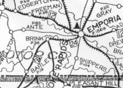
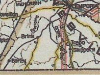
Route 24: Emporia, North Carolina Line
VA 24 ran only from VA 12 (now US 58 Bus) Emporia southwest via SR 627 Brink Rd to the North Carolina Line.
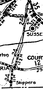
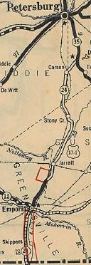
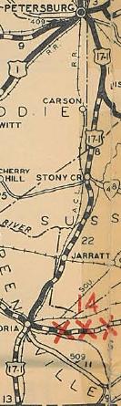
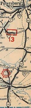
In April 1924 (CTB), VA 24 was extended north as new routing 7.5 miles north of Emporia along Halifax Rd. A second piece of VA 24 was created running from Carson south 4 miles along Halifax Rd in Dinwiddie County. This second piece did not connect to any other part of the system. In Feb 1925 (CTB), the Carson piece was extended noth 5 miles and the original piece was extended north 5 more miles. In 1926, VA 24 was made continuous from VA 35 Templeton south to North Carolina via Emporia. There is no CTB reference and this may have been an act of legislature, as there is an CTB note in 1923 that this road was supposed to be part of the original state highway system but was erroneously left out. In late 1926, US 17-1 was assigned to the entirety of VA 24. This had initially been proposed as US 15, which appears on the 1926 Official. In late 1928, VA 24 was moved onto US 301's modern route (excluding parts affected by I-95 at overpasses/interchanges). This removed the highway entirely from Dinwiddie County. The original Halifax Road route is approximated: Halifax St north of today's US 58 Business, a bit of US 301, then SR 616 through Moonlight. VA 24 then followed SR 609 into Sussex County. After a bit of US 301, VA 24 then used SR 646 (with a bit of VA 139) through Jarratt. After more US 301, VA 24 used SR 640 northeast to SR 659 (old VA 40) then west back to modern 301 over mostly non-road today. VA 24 used VA 40 business in Stony Creek, then SR 618 into Dinwiddie County and on to Carson. VA 24 then picked up SR 604, then SR 621, then SR 605 which before I-95 used to connect to US 301 at Millpond Rd. The 1928 reroute changed VA 24's northern endpoint from today's US 301/Millpond Ln jct south to US 301/VA 156/SR 668 jct just northeast of I-95. In late 1932, US 17-1 was renumbered as US 301. In July 1933, VA 24 was dropped from US 301.
| |||||||||||||||||||||||


Previous: VA 23 |
Next: VA 25
Top | Virginia Hwy Index
Home
Page last modified 28 February 2015