ROUTE LOG
WV STATE LINE: 0 - 0
I-64 EB (exit 10), VA 159: 10.01 - 10.01
Covington-Alleghany Line: 4.69 - 14.70
VA 154: 0.09 - 14.79
US 220 NB: 0.97 - 15.76
VA 18: 0.38 - 16.14
Alleghany-Covington Line: 0.46 - 16.60
I-64 WB (exit 16): 0.72 - 17.32
US 60 Bus, US 220 Bus, VA 384: 7.18 - 24.50
US 60 Bus, US 220 SB: 3.63 - 28.13
VA 42, VA 269: 1.78 - 29.91
VA 269: 6.38 - 36.29
Rockbridge-Alleghany Line: 5.34 - 41.63
I-64 EB (exit 50): 9.30 - 50.93
Lexington-Rockbridge Line: 5.60 - 56.53
US 11 Bus: 0.72 - 57.25
US 11: 0.73 - 57.98
Rockbridge-Lexington Line: 0 - 57.98
I-81 (exit 188): 2.15 - 60.13
Buena Vista-Rockbridge Line: 3.07 - 63.20
US 501: 0.61 - 63.81
Rockbridge-Buena Vista Line: 1.31 - 65.12
VA 48 (Blue Ridge Pkwy): 3.12 - 68.24
Amherst-Rockbridge Line: 0 - 68.24
US 29 Bus: 22.08 - 90.32
US 29: 0.45 - 90.77
Nelson-Amherst Line: 8.27 - 99.04
Appomattox-Nelson Line: 6.33 - 105.37
VA 26: 0.10 - 105.47
Buckingham-Appomattox Line: 4.04 - 109.51
VA 24: 9.37 - 118.88
VA 56: 2.02 - 120.90
US 15: 5.78 - 126.68
Cumberland-Buckingham Line: 8.38 - 135.06
VA 45 SB: 4.06 - 139.12
VA 13: 3.51 - 142.63
VA 45 NB: 1.34 - 143.97
Powhatan-Cumberland Line: 6.05 - 150.02
US 522: 9.60 - 159.62
VA 300: 1.85 - 161.47
VA 13: 1.23 - 162.70
Chesterfield-Powhatan Line: 3.87 - 166.57
VA 288: 1.69 - 168.26
VA 147: 4.35 - 172.61
VA 76: 2.91 - 175.52
VA 336: 1.95 - 177.47
VA 150: 0.30 - 177.77
Richmond-Chesterfield Line: 0 - 177.77
VA 161: 2.16 - 179.93
US 60 TRUCK: 0.62 - 180.55
US 1, US 301: 1.80 - 182.35
VA 147 WB: 1.30 - 183.65
US 60 TRUCK, US 360 WB, VA 147 END: 0.45 - 184.10
US 360 EB: 0.38 - 184.48
VA 5 BEGIN: 0.43 - 184.91
VA 5 EB: 0.30 - 185.21
Henrico-Richmond Line: 1.78 - 186.99
VA 156 NB: 3.34 - 190.33
VA 33 WB: 1.38 - 191.71
VA 33Y: 0.05 - 191.76
I-295 (exit 28): 1.33 - 193.09
VA 156 SB: 2.24 - 195.33
New Kent-Henrico Line: 1.85 - 197.18
VA 33 EB, VA 249: 0.91 - 198.09
VA 106: 4.03 - 202.12
VA 155: 5.50 - 207.62
James City-New Kent Line: 8.58 - 216.20
VA 30: 5.05 - 221.25
VA 199: 6.47 - 227.72
Williamsburg-James City Line: 1.89 - 229.63
York-Williamsburg Line: 1.67 - 231.30
VA 132: 1.12 - 232.42
Williamsburg-YOrk Line: 0 - 232.42
VA 5 EB: 0.16 - 232.58
VA 5 WB: 0.56 - 233.14
James City-Williamsburg Line: 0.60 - 233.74
VA 199: 1.34 - 235.08
York-James City Line: 0.04 - 235.12
James City-York Line: 2.53 - 237.65
Newport News-James City Line: 3.10 - 240.75
VA 238: 1.70 - 242.45
VA 105: 1.61 - 244.06
VA 173: 3.34 - 247.40
VA 312: 5.51 - 252.91
VA 306: 1.07 - 253.98
VA 152: 1.49 - 255.47
US 17, US 258, VA 32: 1.08 - 256.55
VA 351: 2.40 - 258.95
I-664 (exit 7): 0.98 - 259.93
Hampton-Newport News Line: 2.07 - 262.00
VA 143 NB: 3.25 - 265.25
VA 134: 0.39 - 265.64
I-64 WB (exit 267), VA 143 SB: 1.13 - 266.77
VA 169: 0.33 - 267.10
Norfolk-Hampton Line: 4.00 - 271.10
I-64 EB (exit 273): 1.83 - 272.93
US 60 ALT, VA 168: 0.30 - 273.23
US 60 ALT, US 460: 0.90 - 274.13
VA 194: 0.47 - 274.60
VA 170: 3.96 - 278.56
Virginia Beach-Norfolk Line: 0.97 - 279.53
VA 166: 0.22 - 279.75
VA 225: 1.81 - 281.56
US 13: 1.05 - 282.61
VA 279: 3.26 - 285.87
VA 343: 1.18 - 287.05
US 58: 6.97 - 294.02
US 58 Bus: 0.99 - 295.01
US 60 END: 1.15 - 296.16
|
|
Creation: Appeared in late 1926 as an original US Highway,
running from West Virginia to Newport News via Covington, Lexington,
Lynchburg, Farmville, Richmond and Williamsburg. In this routing, US 60
was added to:
VA 14 from the West Virginia line to Lexington.
VA 33 from Lexington to Natural Bridge.
VA 141 from Natural Bridge to Natural Bridge Station.
VA 14 from Natural Bridge Station to Lynchburg.
VA 10 from Lynchburg to Burkeville.
VA 20 from Burkeville to Richmond.
VA 39 from Richmond to Newport News.
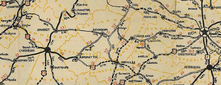
Here is a more detailed look at the history of US 60 from a geographic standpoint.
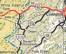
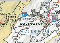
West Virginia Line to Lexington
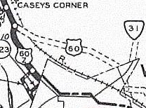
US 60 initially entered Virginia at today's VA 311's northernmost
crossing near I-64. It followed today's VA 311 to Crows, then turned
northeast on today's VA 159. Here, US 60 followed an older alignment of
this road, much of which survives as access driveways to people's
houses, complete with old small bridges over streams. About halfway up
VA 159, it appears US 60 followed today's VA 159 more directly. Just
past SR 661, US 60 originally veered east on today's SR 710 to cross
Dunlap Creek. I-64 cuts off the original route today, but US 60 then picked up
today's US 60 just east of Exit 10. US 60 followed today's US 60 to
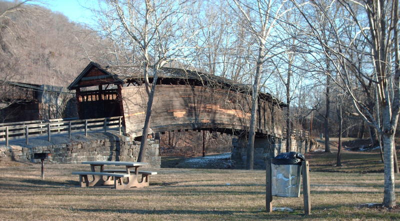
Covington but used the Humpback Covered Bridge and used today's SR 645
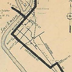
through Teaberry Flats. US 60 entered Covington on Bridge St, then
turned south on VA 154 Water St, then east on Lexington St, then north
on Chestnut St, then east on Highland St over to today's US 60-220.
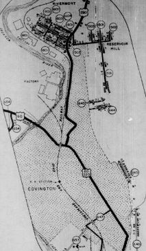
Original US 60 followed US 60-220 east out of Covington, then
followed SR 1104 paralleling the north side of I-64. About where I-64
crosses the Jackson River east of Covington, US 60 used to cross the
river and parallel the railroad tracks - this alignment is now part of
I-64's footprint. Original US 60 leaves this footprint just west of Low
Moor, using Kams Rd (frontage road south of I-64) and SR 696 through
Low Moor and Selma.
|
|
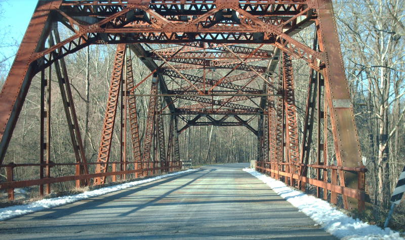
US 60 crossing of Dunlap Creek from 1934-71
Click for larger image |
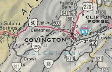
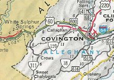
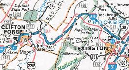
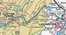
Original US 60 picked up US 60-220 Business heading into Clifton
Forge, using the east bound one-way split on Ridgeway as the two-way
route. East of town, US 60 veered north on Ingalls Dr then east on SR
662 Chesnut over toward the east end of US 60 Bus, then picked up SR
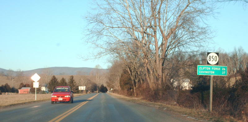
632 Longdale Furnace Rd. US 60 used today's VA 269, then SR 850 over
the mountain and through Denmark. At Kerrs Creek it picked up today's
US 60 all the way into Lexington.
Adjustments:In 1928, US 60 was removed from the James
River and Kanahwa Turnpike through Teaberry Flats, leaving behind CR
236 (today's SR 645). Also, based on bridge dates, US 60 was
straightened out on today's VA 159.
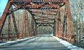
In 1929, US 60 was removed from the Humpback Bridge.
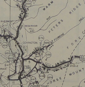
About 1936 (RR overpass date), US 60 was given its current route through Covington.
US 60 early route through Covington
1929 Official
|
US 60 straightened out in Covington
1938(?) Alleghany County
|
In Oct 1947 (CTB), US 60 was rerouted west of Callaghan to run
directly west to White Sulphur Springs, WV. This was a renumbering of
US 60 ALT. The old path through Crows became VA 159 and an extended VA
311.
Between 1945-49, US 60-220 was placed on new alignment east of VA 18, leaving behind SR 689 (now cut off by I-64...today it is a little stub E. Echols Rd; SR 689/647 Interstate Dr; destroyed by 64 on the eastern end).
US 60 original Covington routing east of VA 18
1944 Alleghany County
|
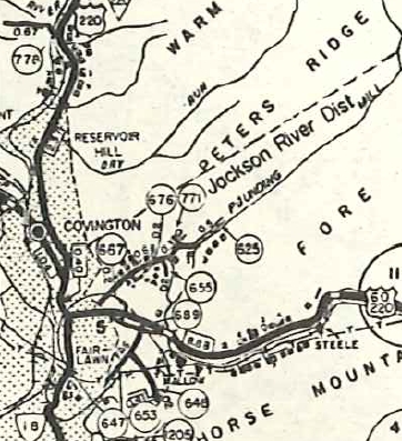
US 60 bypassing SR 689 east of VA 18
1958 Alleghany County
|
About 1953, US 60 was put on what is now I-64's footprint bypassing Low Moor and Selma, leaving behind SR 696.
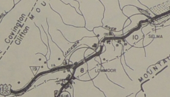
US 60-220 through Selma and Low Moor
1944 Alleghany County
|
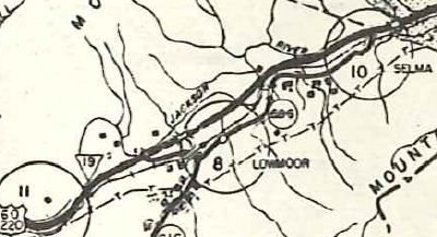
US 60-220 bypasses Selma and Low Moor
1958 Alleghany County
|
In 1965, US 60-220 was removed from SR 1104 Valley Ridge Rd east of Covington and placed onto the new I-64. Note that US 60-220 always crossed the Jackson River essentially where I-64 does now, and not where SR 1101 Winterberry Ave does by Alleghany High School. I-64 was built directly on top of US 60-220 from the Jackson River bridge east to the US 60-220 Bus/VA 384 exit west of Clifton Forge.
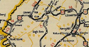
US 60 original route WV to Lexington
1926 Official
|
US 60 avoids Crows
1948 Official
|
US 60 added to I-64 between Covington and Clifton Forge
1966 Official
|
In July 1967 (CTB), US 60 was placed on the new I-64 from the West Virginia
Line to Exit 7. Some segments of the old route 60 not directly on the
interstate's footpath are part of F-046.
In Aug 1967 (CTB), US 60 was placed on the new I-64 from Exit 7 to Exit
10. This left behind some SR 661, a tiny bit of VA 159 and SR 710. This didn't show up on official maps until the 1971 issue.
US 60 onto I-64 from WV to Exit 7
1967 Official
|
US 60 added to I-64 between Exit 7 and Exit 10
1971 Official
|
In Oct 1979 (AASHTO), US 60 was added to new I-64 between today's US 60
Business east of Clifton Forge and VA 42. This left behind SR 632.
Jan 1984 (CTB), US 60 was added to I-64 from VA 42 to Kerrs
Creek, leaving behind today's VA 269 and a lengthy SR 850. I-64 had
been opened a couple years already and AASHTO approved this change in Nov 1982.
In Dec 1987 (AASHTO), US 60 was placed on I-64 bypassing Clifton Forge. The old route through town became US 60 Business.
US 60 onto I-64 from east Clifton Forge to VA 42
1980 Official
|
US 60 added to I-64 between VA 42 and Kerrs Creek
1984 Official
|
US 60's old westbound view leaving the Kerr's Creek area
Click for larger image
|
Lexington
US 60 historically used its current route from the west along
Nelson St. then south on Main St joining US 11/VA 33. US 11-60 followed
Main St south to Thornhill Rd to VA 251.
In May 1933 (AASHO), US 60 was rerouted to go north on Main St with US 11, then east on Washington St.
In Aug 1939, (CTB) the duplex with US 11 was removed altogether and US 60 was a straight shot through town as it is today.
US 11-60 initially used VA 251 south to SR 764 then cut southeast
back to today's US 11. The route followed today's US 11 to below the
current Fancy Hill exit with I-81, then veered southwest on today's SR
609 then over SR 743 back towards modern US 11. The original US 11-60
used SR 743 which hugs US 11 closely down to near Natural Bridge where
the route picked back up modern US 11.
US 60 split from US 11 by using today's VA 130 east. US 60
initially used today's SR 773 Lloyd Tolley Rd through Natural Bridge
Station, and then today's VA 130 to Glasgow. US 60 then followed
today's US 501 over the mountain and over the dam crossing the James
River.
It appears that US 60 followed today's modern US 501 through Big
Island to Boonsboro, but likely used Winding Creek Ln north of
Boonsboro. US 60 followed today's US 501 Business until it cuts south
on Langhorne Rd, and continued into Lynchburg on Rivermont Ave.
US 60 original routing - Lexington-Lynchburg-Burkeville-Richmond
1926 Official
Lexington to Lynchburg
Adjustments: In August 1928, the state designation with US
60 from Natural Bridge to VA 14 (now SR 608) was renumbered from VA 141
to VA 801.
In 1930, US 60 was removed from Natural Bridge Station and
placed on what is the current VA 130 through the area, leaving behind
CR 110.
By 1932, US 60 was placed on the current US 501 near Boonsboro.
In May 1933 (AASHO), US 60 was removed from the Lexington-Lynchburg
corridor, leaving behind US 11 from Lexington to Natural Bridge; VA 249
Natural Bridge to Glasgow; US 501 Glasgow to Lynchburg.
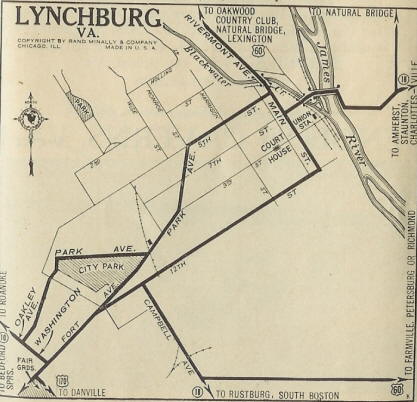
Lynchburg
US 60 followed Rivermont to downtown, which turns into Main St. US
60 continued down Main to Pine St where it cut east (not possible now),
then southeast via Lynch St and Garnet St to Concord Turnpike. US 60
followed Concord Turnpike east out of town to today's Old Richmond Hwy.
About 1929, US 60 was rerouted to cut south from Main St onto 12th
St then southeast on Campbell Ave to today's US 460 Business. US 60
then headed out of Lynchburg on today's US 460.
In May 1933 (AASHO), US 60 through Lynchburg was renumbered as US 501.
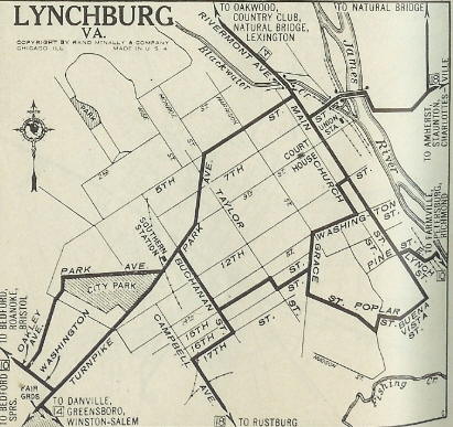
US 60 original Lynchburg routing.
1925 Auto Trails
|
US 60 rerouted in Lynchburg
1929 Auto Trails
|
Lynchburg to Richmond
US 60 followed US 29-460 east out to Old Richmond Hwy then east
(now cut off by the new US 29 freeway) back to US 460. US 60 followed
modern US 460 until nearly Concord, then used SR 800 through that
community. US 60 picked back up US 460 over to Appomattox, except it
used SR 689 through Spout Spring.
US 60 appears to have followed US 460 Business through Appomattox
although it used SR 1004 in the SR 727 junction area. US 60 may have
briefly used the original VA 10 routing that very closely followed the
railroad through Evergreen and most of the way to Pamplin.
US 60 used US 460 Business through Pamplin. US 60 then followed US
460 east of Pamplin. US 60 -may- have used SR 655-628-608 in the
Prospect area but quit doing so by 1928 if it did. Approaching
Farmville, US 60 used the lengthy SR 695. Through Farmville itself US
60 followed today's US 460 Business.
US 60 followed US 460 east of Farmville, then dipped south on
today's SR 600 through Rice, then southeast on SR 735 to modern US 460.
US 60 followed US 460 to Burkeville except it used the SR 736 loop. At
Burkeville, US 60 used SR 716 Namozine St (partly cutoff from US
360-460 now), then US 360 Business 2nd St.
US 60 followed today's US 360 corridor northeast from Burkeville
(a few bits of old alignment are visible from the 4-lane alignment
today). |
|
US 60 westbound at US 501's original north end in Burkeville
Click for larger image |
US 60 used SR 671 through Jetersville and SR 697 through Maplewood
but otherwise US 360. Approaching Amelia, US 60 veered north on SR 656
S. Amelia Ave and used that to Amelia CH.
US 60 picked up today's US 360 Business heading east from Amelia
CH. It continued on Goodes Bridge Rd past US 360 which loops back
around to US 360. US 60 used US 360 east to Chesterfield County except
at SR 604 it used Mt. Olive Ln and near VA 153 it used SR 698 Circle
Dr.
In Chesterfield County, US 60 followed US 360 all the way in to
Richmond, but did initially use SR 690 Cosby Rd, which once crossed US
360 and connected to today's Ashbrook Pkwy, then N. Spring Run Rd north
back to US 360. Further east it used Lockhart Rd-Hicks Rd-Walmsley
Blvd-Goode Bridge Rd
Adjustments: About 1932, US 60 bypassed Rice by using today's US 460 to SR 735. This left behind CR 10.
Also about 1932, US 60 was placed on modern US 360 through Chesterfield County, leaving behind CR 241 and CR 244.
In May 1933 (AASHO), the Lynchburg to Burkeville segment became part of US
460 (Virginia had reuested US 86) and the Burkeville to Richmond segment became part of US 360 (Virginia had requested US 33).
Lexington to Richmond
In May 1933 (AASHO), US 60 headed east out of Lexington and used its
current routing to Buena Vista. However, at the then-WCL of Buena
Vista, US 60 used Orchard St which curls around to the south before the
railroad and no longer crosses the small stream. US 60 continued south
on Alleghany, then east on Factory to Beech, then north to 29th before
heading east on current US 60. US 501 actually split off at the
Factory-Beech intersection. Most of this was a renumbering of part of
VA 14 although some was shown on the 1932 Rockbridge County map as not
yet present.
US 60 followed its current routing over the mountain into Amherst
County, which was either a renumbering of a briefly rerouted VA 13 or
new construction altogether to SR 605. East of here US 60 was replacing
VA 13 all the way to Richmond.
US 60's routing was the same in May 1933 as today through Amherst
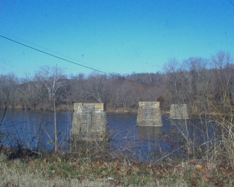
and over to Bent Creek. Just west of the James River it used SR 819
Caskie Dr to the original bridge (piers still standing), then SR 717 on
the Bent Creek side of the river.
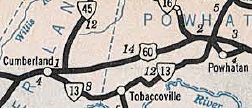
US 60's 1933 route used today's US 60 through Buckingham CH but
used SR 690 from the Lee Wayside over to the Sprouses Corner area. US
60 then picked back up modern US 60 to Cumberland CH except it used the
SR 619 loop east of VA 45.
|
|

US 60's initial James River crossing was here
Click for larger image |
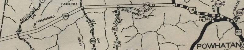
East of Cumberland CH, US 60 followed today's VA 13 through
Tobaccoville and over to Powhatan CH, except modern US 60 clips the
original routing a little west of the courthouse. US 60 followed VA 13
to its end with US 60 in Plain View then followed the loops of SR 653,
679, 678, 676 and 675 along the modern US 60 corridor to Chesterfield
County.
It appears the 1933 routing of US 60 in Chesterfield County used
today's US 60 all the way to Richmond except at the VA 161 area it used
"Old Midlothian Tpk".
Adjustments:By 1936, US 60 was placed on its modern
alignment between Cumberland CH and Chesterfield County. This left
behind VA 13 and all the SR 67x loops (initially some of these were extensions of 61x and 63x routes). Note that the new construction between Cumberland CH and SR 684 near Powhatan CH was briefly VA 284 during the construction phase first.
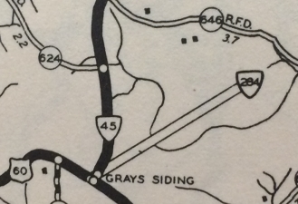
VA 284 east of US 60/VA 45
1933 Cumberland County
|
VA 284 west of US 60/VA 16
1933 Powhatan County
|
VA 284 becomes US 60
1936 Official
In Dec 1938 (CTB), US 60 was placed on its current Buena Vista routing.

Initial US 60 routing
1940 USGS Topo
|
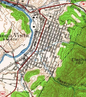
Current US 60 routing
1950 USGS Topo
|
Between 1942-44, US 60 was straightened out between Buckingham CH and US 15 leaving behind SR 690.
In 1955, US 60 was placed on its current routing through the VA 161 interchange.
Before 1958 US 60-VA 45 was put on its modern alignment leaving behind SR 616 west of Buckingham CH.
In 1965, US 60 was put on its modern crossing of the James River leaving behind SRs 717 and 819.
In early 2022, a bill in the Virginia State Legislature was proposed that would have moved US 60 onto I-64 from SR 623 Kerrs Creek to US 11, then south with US 11 back to US 60. This bill did not make it out of committee.
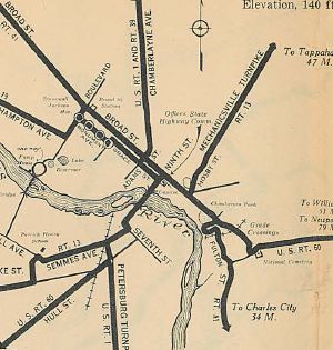
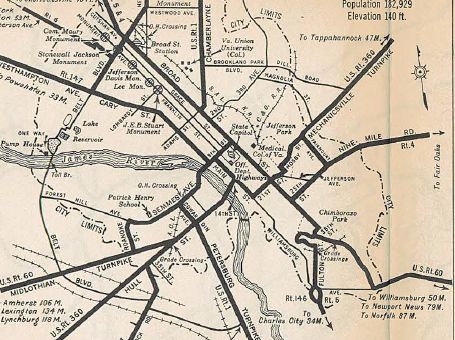
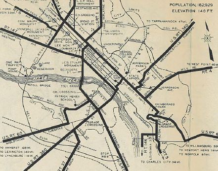
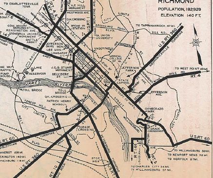
Richmond
Originally, US 60 came in on Hull St then joined US 1 on Cowardin
Ave to Semmes Ave to the bridge at 9th St. US 60 followed 9th St to
Broad St then east to 36th St, south to Government Rd east out of town.
In 1931, US 60 was rerouted to follow Hull all the way to the 14th
St bridge, as US 360 does today. Then US 60 turned east on Main, then
north on 21st to Broad then east as it did before.
In May 1933 (AASHO), US 60 was removed from Hull (renumbered as US 360)
and instead came in along Midlothian Turnpike (replacing VA 13). It
appears US 60 used its current Roanoke St to Semmes Ave to a bridge at
9th St which it followed to Broad, then east as before.
US 60 using Hull/Cowardin/Semmes/9th St Br/Broad
1929 Official
|
US 60 using Hull/14th St Br/Main/21st/Broad
1932 Official
|
US 60 with US 60 using Midlothian Tpk/Roanoke/Semmes/9th St Br/Broad
1934 Official
|
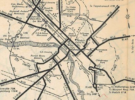
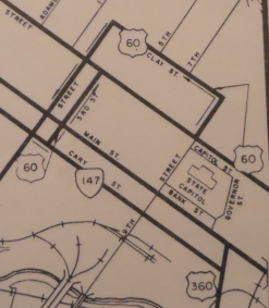
In April 1934 (CTB), US 60 was rerouted to stay with US 1
In Aug 1935 (CTB), US 60 was moved to used 2nd St between US 1 and Broad.
US 60 rerouted to follow US 1 across the river to Broad
1935 Official
|
US 60 rerouted to 2nd St between US 1 and Broad
1936 Official
|
In Oct 1950 (CTB), US 60 was split onto one-way routings: EB used
2nd to Broad as before, but WB used Broad to 1st, then south to Cary
then east to 2nd before heading south to US 1.
In Nov 1953 (CTB), US 60's one-way splits were changed. EB still just used 2nd to Broad. EB left broad at 11th, went north 2 blocks to Clay St, then west to 1st St which it followed south as it had since 1950.
In April 1955 (CTB), EB used Cary to 3rd St north to Broad. WB was changed to leave Clay St at 2nd St instead of 1st.
The Sept 1959 CTB minutes imply US 60 was returned to run both ways
on 2nd to Broad as it had prior to 1950 (there was an explicit
description of all Richmond primary routes). The description of VA 33
implies only Broad St as its routing. However, there is no mention of
Clay St to city street status, as it explicitly mentions happens to
Belvidere St when US 1 left it at that time). Thus, I believe US 60's
routing did not actually change given the March 1962 change below.
Although there is room to do so, no official map in the 1950s-1970s
showed any of the re-routings of US 60, nor do any of the 1950s Henrico County maps.
In March 1962 (CTB), US 60 westbound was rerouted to leave Broad
at 9th instead of 11th north to Clay, as the new Civic Center opened,
closing part of Clay Street.
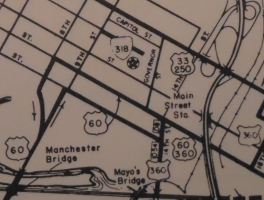
In June 1974 (CTB), US 60 was moved onto the Manchester Bridge as
it is today. US 60 then split into one-way routings: EB using 9th and
Cary and 14th to Main St which US 60 followed east to 21st, then north
to Broad. WB used Main from 21st to 8th St.Broad St from 2nd to 18th
became an extended US 33-250 in the process. US 60 was also split into
a one-way setup on Broad and 21st: EB used 21st to Broad. WB used 23rd
north to Marshall then west to 21st south across Broad.
US 60 WB using 9th to Clay
1969 Henrico County
|
US 60 rerouted over Manchester Bridge and Main St
1975 Henrico County
|
In Sept 2003 (CTB), US 60 was rerouted to avoid Broad St altogether
by staying on Main St east all the way to Williamsburg Rd, then east on
Stoney Run Dr to connect with Government Rd, reconnecting to US 60's
historical east exit of Richmond. Broad St was turned into a minor
neighborhood street with numerous 4-way stops.
Richmond to Williamsburg:
Initially, US 60 followed modern US 60 to Sandston, then "Old
Williamsburg Rd" east (cut off by I-295 now) which runs to Bottoms
Bridge. The US 60 followed its current routing to the Roxbury area
where it picked up SR 631 (no longer exists west of VA 106) for a
while.
US 60 picked back up its current routing, then used SR 629
through Providence Forge. It is unclear if it ever used the SR 629
piece that runs north of present US 60. US 60 followed modern 60 east,
then used SR 649 through Walkers to Lanexa.
US 60 picked up its current route here and used it over to VA 30
except at Edwards Swamp where it used "Old Route 60". US 60 followed
modern 60 through Norge and Lightfoot approaching Williamsburg.
US 60 was placed on its modern alignment from VA 33-249 to VA 30 about 1947.
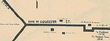
Williamsburg:
US 60 initially used Richmond Rd (old VA 162 endpoint) straight to
central Williamsburg, then Duke of Gloucester St east then south around
the Old Capitol using Blair, Francis and Waller Sts to York St east out
of town.
In Dec 1934 (CTB), US 60 was placed on its current bypass of
Williamsburg, as new construction that began as VA 39-A in 1931. The
old route into town became US 60-Z. Today only a small piece on its
eastern end is primary, part of VA 5.
US 60 early route through Williamsburg
1929 Official
|
US 60 bypasses Williamsburg
1936 James City County
|
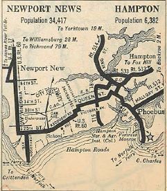
Williamsburg to Hampton:
US 60 followed its current route east of Williamsburg down to the
Denbigh area of Newport News. Originally, US 60 used Old Courthouse Way
at VA 173, then Campbell Rd on the east side of modern 60. It is
unclear if original US 60 used today's Smucker Rd (no longer forms a
complete loop if it ever did), but it did use Mitchell Point Rd and
Nettles Rd on the east side of today's US 60.
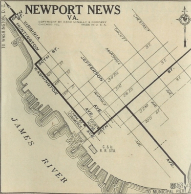
It appears from the south end of Nettles, original 60 followed
today's 60 down Warwick Blvd to 64th St where it cut west to
Huntington, then south to 50th, west to Washington Ave, then south to
25th. US 60 used 25th east to Jefferson Ave which it followed south to
end at the ferry to Norfolk.
By 1929, US 60 appears to have been routed to use today's Warwick
south of present US 17-258 all the way to 25th instead of zig-zagging
around.
In May 1930 (AASHO), US 60 was rerouted away from the ferry landing on
Jefferson and instead headed south on today's Warwick Blvd east on
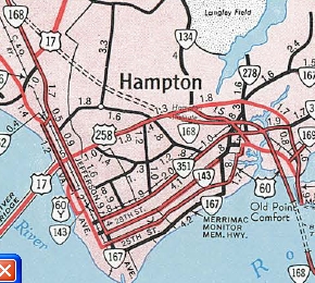
25th, turning into Kecoughtan Rd. Near Hampton, US 60 zig-zagged on
Jackson St (now Kecoughtan), Victoria Ave (now Settlers Landing) and
Armistead Ave then east on Queen St which crossed the Hampton River. US
60 then picked up E Queen St south to Tyler St which ran east to
today's VA 143 which US 60 followed to Phoebus, but continued on County
St and Water St down to Mill Creek. US 60 then used VA 143's approach
to Fort Monroe, then used Ingalls Rd through Fort MOnroe down to the
ferry landing at Old Point Comfort.
About 1944, US 60 was rerouted on Fort Monroe to use McNair instead
of Ingalls, following the edge of the island to the ferry landing.
In 1957, US 60 was put on existing VA 168 (now I-64) to cross the
new Hampton Roads Bridge-Tunnel. The old route through Phoebus to Fort
Monroe became part of an extended VA 143.
US 60 early route through Newport News
1929 Auto Trails
|
US 60 rerouted to Hampton/Ft Monroe
1932 Official
|
US 60 moved onto new HRBT
1959 Official
|
In Aug 1957 (CTB), US 60 was split into one-way routings in central
Hampton. EB stayed as before. WB left Queen using Eaton north to
Lincoln west to Armistead south to Queen.
In Sept. 1961 (CTB), US 60 was rerouted in downtown Newport News
to use 25th St west to Warwick Blvd north. This replaced US 60 ALT.
Sometime before 1963, US 60 was placed on one-way splits using 25th and 26th Streets from Warwick east to Buxton Ave.
About 1974, US 60 was placed on one-way splits between 50th and
71st Sts. US 60 WB continued to use Warwick Blvd. US 60 EB used
Huntington Ave to 50th St. The US 60 EB routing was a renumbering of US
60-Y. It apprears that US 60 may have been placed on one-way splits all
the way down to 25th-26th Sts.
Maps do not show either set of one-way splits in Newport News.
About 1975, US 60 was placed on the modern Warwick Blvd (new
construction) in the Denbigh area southward, leaving behind Old
Courthouse Way, then Campbell Rd, Mitchell Point Rd and Nettles Rd.
In Jan 1979 (CTB), US 60 was removed from Queen St in Hampton and
instead put on Settlers Landing Rd. The Armistead Ave piece of US 60
became an extended VA 134. Queen St became a mall. Since I can find no
other CTB reference, I assume this is when the one-way split involving
Eaton and Lincoln Streets went away.
When I-664 was extended south to the Monitor-Merrimac Tunnel in
the early 1990s, US 60 was reconfigured to make way for the ramps
everywhere. This caused US 60 to have a unique configuration where it
duplexes with itself - US 60 WB crosses over I-664 then turns left on
US 60 EB to curl back around under US 60 WB's bridge over I-664 to
reume its path on Warwick Ave. This routing is not shown in the traffic
logs.
Norfolk to Virginia Beach:
In 1929, US 60 reached Norfolk via ferry to what is now Norfolk
Naval Base, then headed down with VA 27 on Hampton Blvd. US 60 then cut
over on 21st St to Colonial Ave south to Princess Anne Rd where it
picked up US 117 and headed east to pick up Virginia Beach Blvd. US 60
then followed Virginia Beach Blvd all the way to the oceanfront, ending
at VA 101 Atlantic Ave.
In May 1930 (AASHO), US 60 was removed from downtown Norfolk altogether
and instead entered Norfolk via ferry at Ocean View on Willoughby Spit.
US 60 followed Ocean View Blvd, picking up modern US 60 after 4th View.
US 60 appears to have followed its current routing essentially all
the way to Seashore State Park, where it then continued to followed old
VA 305 through Cape Henry and around to the north end of Atlantic Ave.
US 60 followed Atlantic Ave to end at US 117 Virginia Beach Blvd/17th
St.
In July 1933, US 60 was extended south on Atlantic Ave across
Rudee Inlet onto today's S. Atlantic Ave to end at Camp Pendleton,
replacing a piece of VA 12.
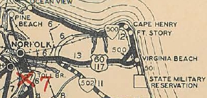
US 60 through Norfolk and on Virginia Beach Blvd.
1929 Official
|
US 60 rerouted away from Norfolk
1930 Official
|
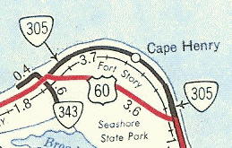
In August 1941 (CTB), US 60 was placed on its current routing
bypassing Cape Henry and Fort Story, leaving behind VA 305 (not
numbered officially today).
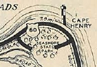
US 60 through Cape Henry
1940 Official
|
US 60 bypasses Cape Henry
1952 Official
|
The east end of US 60 gets murky after 1941. The 1938 and 1941 CTB referred to problems with the Rudee Inlet Bridge. A 1952 photo from the Virginian Pilot newspaper shows this bridge gone, as does the 1948 topo map of this area. What appears to have happened is that the original bridge was torn down (there were other bridges slightly west for people to use, including one that was east of the current set of bridges). My educated guess (based on what is true regarding VA 92 and VA 125 today) is that US 60 on paper continued to end at Camp Pendleton while functionally ending at Rudee Inlet with the idea that someday the bridge would be replaced. It is currently not known if there was detour US 60 signage over then-SR 671 or whatever.
In May 1958 (CTB), US 60 was rerouted onto Pacific Ave from 44th
Ave southward to 17th Av then east back to Atlantic. Pacific Ave was a
lot of new construction and it had originally been envisioned to make
this one-way splits with Atlantic and Pacific. Atlantic Ave from 44th
to 17th became US 60 Business (not numbered today).
In Feb 1961 (CTB), US 60 was formally removed from the long-demolished Rudee Inlet Bridge, leaving a discontinuous piece south of the inlet.
In Sept 1961 (CTB), the piece of US 60 below Rudee Inlet was
decommissioned to SR 601 (see scan under US 60 Business) and US 60
ended at the Atlantic Ave turnaround at 2nd Ave, where it officially
still ends today.

US 60 crosses Rudee Inlet
Note that SR 671 is today's Gen Booth Blvd
1946 Princess Anne County
|
US 60's old routing south of Rudee Inlet, still adorned with narrow concrete (Mapmikey)
Click for larger view
|
Around 1992, US 60 was removed from Ocean View west of 4th View and
instead was sent on 4th View to I-64 to get to the Hampton Roads
Bridge-Tunnel.
US 60 in Ocean View undewent a slight change in July 2004: WB US
60 traffic wishing to get onto 4th View St and on to I-64 (and US 60
West) must turn left onto Mason Creek Rd (via a new traffic signal),
then make a right turn from Mason Creek onto Tidewater Dr, and then on
to 4th View. There is no longer a direct connection/turn from WB Ocean
View onto 4th View. Furthermore, the city made it to where traffic
coming up Tidewater Dr can no longer directly continue onto WB Ocean
View...they can only turn left onto 4th View. Traffic on Tidewater
wanting to take Ocean View onto the Willoughby Spit must use Mason
Creek Rd to make the connection.
Also about 2004, a US 60 END shield appeared on General Booth Blvd at Rudee Point Rd just south of the Rudee Inlet bridge. So the City of Virginia Beach may have rerouted US 60 onto Pacific south of US 58 Business. Of course there are zero postings at US 58 Business. On the flip side, as of 2016 all official VDOT sources continue to show US 60 using Atlantic to the inlet.
Improvements: The following segments of US 60 were paved upon designation in 1926:
Covington to Rockbridge County Line; Lexington to Natural Bridge
Station; Amherst County portion; Boones Mill to Appomatox; Dowdy Corner
to Farmville; Richmond to Bottoms Bridge; Providence Forge to Newport
News
In 1927, US 60 was paved from WV to Crows; Alleghany County line
to Lexington; James River Dam to Lynchburg; Farmville to today's SR 696
By 1929, US 60 was paved Crows to Covington; Glasgow to Amherst County
In 1931, US 60 was paved from Natural Bridge Station to Glasgow.
In 1932, all remaining segments were paved: Appomattox to
Farmville; SR 696 to Burkeville and Richmond; Bottoms Bridge to
Providence Forge.
The 1933 Official shows the new US 60 routing from Lexington to Richmond as paved.
The earliest multilaning of US 60 apparently is its US 1 duplex
south of the James River which is shown as multilaned on a 1937 Texaco
Map
by 1941 it was multilaned between Newport News and Fort Monroe.
In 1947 (bridge dates) US 60 was 4-laned from Bottoms Bridge to VA 30.
By 1947, US 60 was also multilaned from eastern Ocean View to Pleasure House Rd.
In 1951, US 60 was multilaned: Covington east half way to Low Moor;
south end of the Norfolk Ferry to the section widened in 1947; the
Atlantic Ave portion of the route in Virginia Beach; oddly the piece
from Diamond Springs Rd to Pleasure House Rd reverted to 2-lane on
official maps.
In 1953, US 60 was multilaned from VA 152 south to Huntington Ave.
In 1954, US 60 was multilaned on the new Low Moor-Selma Bypass.
In 1955, US 60 was multilaned from just east of VA 161 to about 2 miles west of 161; US 60 was multilaned into Clifton Forge.
In 1956, the VA 161 area widening was extended most of the way to VA 147.
Starting with the 1957 Official, US 60 is again shown as multilane from Diamond Springs Rd to Pleasure House Rd.
In 1958, US 60 was widened for about a mile east of Pleasure House Rd.
In 1959, US 60 was multilaned from Buena Vista about halfway to Lexington; also, US 60 was widened west to Midlothian.
In 1960 or 1961, US 60 was multilaned on about half of its Semmes
Av route (the western part with Forest Hills is still not shown as
multilane on officials but it is 4-lane undivided) and the 1961
Official is the first to show the US 1 duplex north of James River and
Broad St as multilaned; also, US 60 was multilaned from Lightfoot to US
60-Z; US 60 was widened on its VA 5 Williamsburg duplex; US 60 was
widened from VA 152 north to Nettles Rd; US 60 was widened across
Lynnhaven inlet to Old Great Neck Rd.
In 1962, US 60 was widened from Norge to Lightfoot.
In 1964, US 60 was widended from Old Great Neck Rd east to about a mile east of VA 343.
In 1967, US 60 was 4-laned by being put on I-64 from WV to Exit 7.
In 1968, US 60 was widened fully from Lexington to Buena Vista; also it was widened from Norge to VA 30.
In 1970, US 60 was widened from Midlothian to SR 622 Flat Rock and also in the vicinity of the Richmond Airport near Sandston.
In 1971, US 60 was multilaned by virtue of being on I-64 from Exit
7 to Exit 10; also US 60 widened from SR 622 Flat Rock to VA 300
Powhatan; US 60 was widened on the rest of the Fort Story Bypass.
In 1972, US 60 was widened when added to I-64 around Clifton Forge.
In 1974, US 60 was 4-laned from VA 300 to a little west of US 522;
on the reroute of US 60 from US 1 across the Manchester Bridge; also
from Williamsburg to Busch Gardens (and erroneously further to Carters
Grove); US 60 became multilane across the Hampton Roads Bridge-Tunnel
The 1975 and 1976 Officials erroneously shows US 60 as widened further west in Powhatan County to SR 629.
In 1975, US 60 was multilaned on Warwick Blvd north to a little past VA 173.
In 1976, US 60 was put on one-way splits in Newport News, making it multilane. However even today maps do not show this.
In 1978, US 60 was 4-laned from US 15 west most of the way to Buckingham CH.
In 1980, US 60 was multilaned when it was added on I-64 between
Clifton Forge and VA 42; also US 60 was widened on its new alignment
from Seven Springs to a little east of the VA 156 SB split.
In 1981, US 60 was widened from Cumberland CH west to the VA 45 SB
split; also US 60 is shown widened from VA 162 west of Williamsburg to
VA 132 - I believe the rest of the bypass was widened then as well,
though even the 2008 Official still shows as 2-lane.
In 1984, US 60 was multilaned when it was added to I-64 between VA
42 and Kerrs Creek. The 1984-85 Official finally shows US 60 as not
widened between Busch Gardens and Carters Grove.
In 1988, US 60 was widened from Sandston west past Laburnum Ave; also US 60 was 4-laned from the VA 173 area to VA 105.
When US 60 was moved to all Main St in Richmond, that made Us 60 multilane on a stretch it had not been on Broad St.
There are significant segments of 6+ lanes on US 60 in Newport News
north of US 17-258 and also in Chesterfield County roughly from VA 147
to VA 161.
Posted: Fully posted; As of 2021 cutouts remain in Clifton Forge; all but 1 cutout was removed from Covingon between 2018-21; cutouts west of Lexington removed between 2009-12.
Posting of US 60 in the oceanfront area of Virginia Beach is nearly
non-existent. There is an EB reassurance shield near 35th St and at the
north end of Pacific Ave there are US 60 shields. Otherwise
that is it. There was an erroneous US 60 END shield on General Booth
Blvd just south of the Rudee Inlet Bridge which was present 2004-25.
Reports are that a similar shield in that location was present in the
1970s. In 2025 a US 60 shield appeared on NB Pacific at 5th.
Error black-and-white I-60 shields exist at VA 168 and at 1st View
St in Ocean View; error VA 60 shield exists approaching VA 5 east of
Williamsburg.
Error shields that have been corrected: A VA 60 cutout existed
briefly in mid-90s EB near US 13; VA 60 on I-64 WB BGS approaching VA
30; VA 60 shield on the side road alongside EB I-64 just after crossing
Hampton Roads Bridge-Tunnel; VA 60 shield in a LGS westbound
approaching VA 168
Multiplexes: I-64 #1 (10.01 mi)
US 220 (2.53 mi)
I-64, US 220 (10.81 mi)
I-64 #2 (22.80 mi)
VA 45 (4.85 mi)
US 360 (0.38 mi)
VA 5 #1 (0.30 mi)
VA 156 (1.38 mi)
VA 33, VA 156 (3.62 mi)
VA 33 (2.76 mi)
VA 5 #2 (0.56 mi)
VA 143 (1.52 mi)
I-64 #3 (6.16 mi)
Legislative names: Douthat State Park Way, on its two
I-64 duplexes west of I-81 (since 3/2/97); James A. Anderson Highway,
from Lexington to Richmond (since 7/24/69); Pocahontas Trail, from
Richmond to Hampton (designation 3/21/24 predates US 60); Washington
Burgess Route, from VA 30 to Williamsburg (since 3/5/40); Washington
Rochambeau Highway, from VA 30 to VA 238 except not Williamsburg Bypass
(since 2/20/75); Eula W. Radcliffe Memorial Highway, from Williamsburg
to Newport News (since 4/8/00); Hampton Roads Beltway, I-64 duplex
Hampton Roads (since 4/18/96)
Cpl. Michael Fleming Folland Memorial Bridge, Jackson River in
Covington (since 7/18/96); H. Russel Robey Bridge, Maury River near
Buena Vista (since 2/16/84); Stuart U. Taylor Bridges, Diascund Creek,
New Kent-James City Line (since 3/3/97); John A. Lesner Memorial
Bridge, Lynnhaven Inlet in Virginia Beach (unknown date)
Other names: Monroe Ave/Madison St (Covington);
Nelson St (Lexington); Lexington Ave/29th St (Buena Vista); Lexington
Tpk (VA 48 to Amherst); Richmond Hwy (Amherst to Nelson Co); Midlothian
Tpk (Chesterfield Co and Richmond west of US 60 Truck); Roanoke
St/Forest Hill Ave/Semmes Ave/Manchester Bridge/8th-9th Sts/Main
St/Williamsburg Ave/Stoney Run Rd/Government Rd (Richmond);
Williamsburg Rd (Richmond east of Government Rd and Henrico Co);
Richmond Rd (New Kent-James City line to Lafayette St in Williamsburg);
Bypass Rd/Page St/York St (Williamsburg); Warwick Blvd/Huntington
Ave/25th-26th Sts (Newport News); Kecoughtan Rd/Settlers Landing Rd
(Hampton); 4th View St/Ocean View Ave/Shore Dr (Norfolk); Shore
Dr/Atlantic Ave/Pacific Ave/17th St (Virginia Beach)
Scenic Byway: No segments before 2003
Truck Routes: A Truck US 60 is posted in both directions in
Richmond along Midlothian Pike east of Roanoke Ave (where US 60 turns
north) to Hull St, where it follows US 360 across the James River and
meets back up again with US 60. The point is to eliminate tight left
turns on the mainline US 60.
I think this has been there at least back to the 1990s but could be a bit older...
A 2nd US 60 Truck appeared in Lexington in the early 200s using Lewis St/Washington St through downtown Lexington. It was deposted between 2012-15 per GMSV.
Comment: The logical precursor to I-64 in VA (even though 64
follows US 250 more closely between Richmond and Staunton). US 60 today
is not a major route even where it is nowhere near I-64. That privilege
went to its earliest routing, current US 360-460. US 60 from Buena Vista to
Powhatan passes through some empty space in Central Virginia.
It is very quiet, but does have scenic value.
From Doug Smith I learned that from the 1930's to the 1970's, a
marker for the end of the Daniel Boone Trail (national predecessor to
US 60) sat near the US 58-60 jct.
|