< VA 336 | Home | VA 338 >
VA 337 ALT
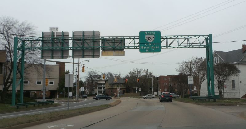
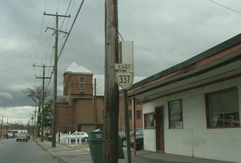
Photo: VA 337 on Hampton blvd leaving Brambleton (photo by Mapmikey, March 22, 2014)
| |||||||||||
| ROUTE LOG US 58 Bus: 0 - 0 US 13 Bus, VA 10, VA 32 Bus: 1.13 - 1.13 US 13 Bus, US 58 Bus, US 460 Bus: 2.87 - 4.00 VA 125: 6.44 - 10.44 Chesapeake-Suffolk Line: 2.52 - 12.96 VA 191: 0.72 - 13.68 I-664 (exit 11): 0.68 - 14.36 Portsmouth-Chesapeake Line: 2.0 - 16.36 VA 239: 2.11 - 18.47 US 58, US 460 ALT WB: 0.23 - 18.70 VA 337 ALT: 0.10 - 18.80 I-264 (exit 4), US 460 ALT EB: 0.15 - 18.95 US 17: 1.45 - 20.40 VA 141: 1.11 - 21.51 VA 239: 0.72 - 22.23 Chesapeake-Portsmouth Line: 0.55 - 22.78 I-464 (exit 4): 0.50 - 23.28 US 460, VA 166: 0.56 - 23.84 Norfolk-Chesapeake Line: 0.74 - 24.58 I-464 SB (exit 5): 0.81 - 25.39 I-264 WB (exit 8), I-464 END (exit 6), US 460 ALT WB: 0.25 - 25.64 US 460 ALT EB, VA 337 ALT: 0.25 - 25.89 I-264 EB (exit 10): 0.22 - 26.11 US 460 WB, VA 168: 0.80 - 26.91 US 460 EB: 0.10 - 27.01 US 460 ALT: 0.31 - 27.32 US 58 EB, VA 337 ALT: 0.20 - 27.52 US 58 WB, VA 337 ALT: 1.38 - 28.90 VA 247: 1.12 - 30.02 VA 165: 2.78 - 32.80 VA 406: 0.18 - 32.98 I-564: 2.85 - 35.83 |
Creation: The earliest explicit reference to VA 337 is the April
1939 CTB Minutes referencing a Hampton Blvd railroad underpass. The first
official map to show the 337 number was the 1944 issue, although it does appear in the 1940 Norfolk County map. The
initial routing of VA 337 was given state mileage in August 1932 CTB without
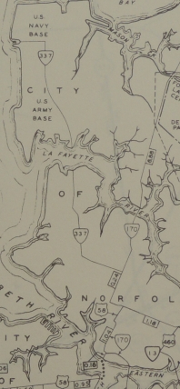
number as 6.5 miles within the city of Norfolk. It ran from VA 170
(current US 460) Granby St west along 21st St to Hampton, then north to
the 98th St ferry (now within Norfolk Naval Base) which connected to Newport News. There is no indication that VA 337 ever continued across the ferry.
VA 337 from Downtown Norfolk out to Norfolk Naval Base using Hampton
Blvd. was not numbered immediately before, though it was once part of
US 17 before 1931.
Adjustments:In May 1943 (AASHO), VA 337 was extended south with VA 170 Granby to central Norfolk, then east with US 58 ALT Princess Anne Rd, then replaced US 460 south on Park Ave and southeast on Brambleton/Campostella and Poindexter through South Norfolk, across the Jordan Bridge to Portsmouth, Chesapeake and Suffolk. VA 337 west ended at today's VA 10-32 which still carried US 58 then.  US 460 Portsmouth to Suffolk 1941-42 Official  VA 337 Portsmouth to Suffolk 1944 Official In Nov 1943 (CTB), VA 337 north was truncated at the end of Hampton Ave. 98th St became part of VA 165 (now unnumbered). It also appears that VA 337 was also rerouted in Norfolk at this time to stay on Granby south with VA 170, south on Bank, then east with US 58 along City Hall Ave then south replacing VA 170 across the Elizabeth River on the now-removed Main St bridge to Liberty St south to previous VA 337 along Poindexter. The old route along Princess Anne Rd became US 58 ALT and Park Ave became part of US 58. Brambleton around to South Norfolk remained part of US 460.
In March 1953 (CTB), VA 337 west was extended from VA 10-32 over old US 58 to its current end with US 58 Bus.
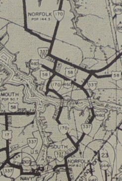
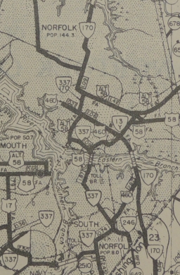
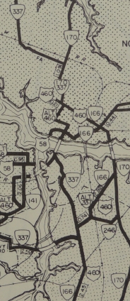
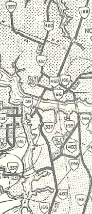
Also in March 1953 (CTB), VA 337 was rerouted in South Norfolk to follow Liberty St north past Main St, then north on State St, then across the new Berkley Bridge into Norfolk, then west on City Hall Ave, then north on Bank St. The old routing across the river via Main St became secondary save for a little US 58 on the Norfolk side. In May 1953 (CTB), VA 337 in South Norfolk was routed onto Bainbridge Ave, instead of Liberty St. The Bainbridge route had been VA 337 ALT. In Nov 1957 (CTB), VA 337 was rerouted off Granby and instead left 21st on Monticello Ave to Virginia Beach Blvd then south on Tidewater Dr and west on City Hall Ave to meet the Berkley Bridge. South of the bridge, VA 337 south was put on Walnut St (destroyed by I-464) to get from the bridge to Liberty St. VA 337 then used Liberty-Main-Bainbridge south to Poindexter. In Nov 1962 (CTB), VA 337 was rerouted in Norfolk to its current use of Brambleton Ave to Hampton Blvd, replacing VA 599. Until then, VA 337 used 21st St to get to Hampton Blvd.
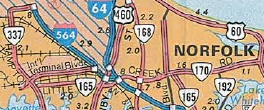
In Jan 1979 (CTB), VA 337 was extended east from Hampton Blvd to the terminus of I-564, replacing a piece of VA 170. Around 1991, VA 337 was moved onto I-464's northernmost quarter-mile. Improvements: Paved since inception; The first official map to show any VA 337 multilaning was the 1955, on its Granby St piece. In 1956, Hampton Blvd was multilaned. In 1957, Portsmouth Blvd was multilaned from US 58 east to Elm St. VA 337 was multilaned on Brambleton Ave when it opened in late 1962 or so, as well as its crossing into South Norfolk. VA 337 is shown as multilane west of US 58 out to nearly Western Branch in 1966. VA 337 was multilaned when it took over the short piece of VA 170 at the Norfolk Naval Base. VA 337 was multilaned past the Western Branch in 1985 or 1986. VA 337 was multilaned out to VA 191 in 1992. Posting: Fully posted; posting is poor in South Norfolk near I-464 and postings have been removed off I-264 including BGSs for Tidewater Drive. There are several turns in a row no longer posted in either direction. Cutouts existed in Suffolk until 2004. VA 337 is erroneously posted as VA 170 still from Bellinger Blvd on Norfolk Naval Air Station; Error US 337 shield found in South Norfolk in 2008 (gone by 2012); error US 337 shields at Alexanders Corner installed since 2012 and still present as of April 2019 (GMSV). Multiplexes: US 460 ALT (0.25 mi) I-464 (0.25 mi) I-264, US 460 ALT (0.25 mi) I-264 (0.22 mi) US 460 (0.10 mi) US 58 (1.38 mi) Legislative names: NONE Other names: Washington St. (inner Suffolk); Nanesmond Pkwy (remainder of Suffolk); Portsmouth Blvd (Suffolk line to Elm Ave Portsmouth); Elm Ave. (Portsmouth Blvd to Jordan Bridge); Poindexter St. (Jordan Bridge to US 460/VA 166); Bainbridge Blvd/Main St/Liberty St/State St (US 460 to I-464); Tidewater Dr (I-264 to VA 168); Brambleton Ave. (VA 168 to US 58 WB); Hampton Blvd. (US 58 to Norfolk Naval Base); Admiral Taussig Blvd (Hampton Blvd to I-564) Scenic Byway: No segments Comment: Takes a convoluted route through the Hampton Roads area. Runs over the Berkley Bridge with I-264 and Alt. US 460, and also includes the new toll Jordan Bridge over the south branch of the Elizabeth River. | ||||||||||
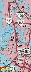
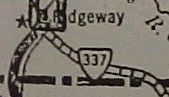
| Previous VA 337's: 1928 ROUTE LOG US 311, VA 33: 0 - 0 NC STATE LINE: 5.5 - 5.5 |
VA 337 #1: Appeared January 1925 as an upgrade to CR 7. Ran from
VA 33 (curr US 220 Bus) Ridgeway to then-NC 709. In August 1928 this
became VA 201.
Today it is a tiny part of VA 87 which has been rebuilt. VA 337 followed today's SRs 750 and 835.
|
||||||||||

Previous: VA 336 |
Next: VA 337 ALT | VA 338
Top | Virginia Hwy Index
Home
Page last modified 26 March 2022