< US 340 | Home | US 401 >
US 360 Bus | US 360 ALT | US 360-Y
US 60 | US 460
Photo: US 360's humble beginning in Reedville (photo by Mapmikey 2/16/07)
| US 360 < US 340 | Home | US 401 > US 360 Bus | US 360 ALT | US 360-Y US 60 | US 460 |
Photo: US 360's humble beginning in Reedville (photo by Mapmikey 2/16/07) |
| ||||||||||||||||||||||||
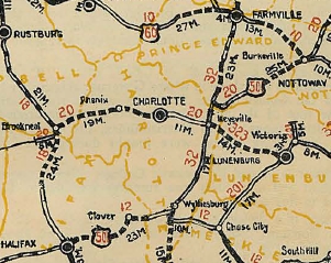
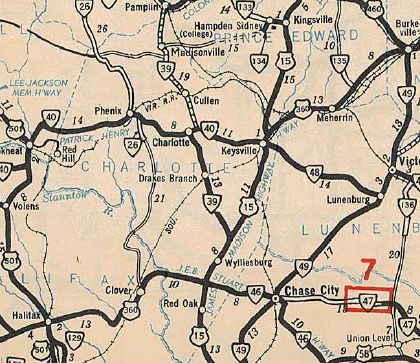
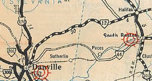
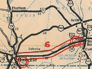
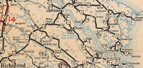
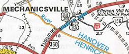
| ROUTE LOG US 58 Bus WB, VA 293, VA 360: 0 - 0 US 29, US 58 WB, US 58 Bus END, VA 785: 1.76 - 1.76 Pittsylvania-Danville Line: 2.10 - 3.86 VA 62: 2.37 - 6.23 Halifax-Pittsylvania Line: 3.32 - 9.55 VA 119: 3.48 - 13.03 US 501: 15.83 - 28.86 US 58 EB: 0.70 - 29.56 VA 304: 0.61 - 30.17 VA 34: 0.52 - 30.69 VA 344, VA 360: 7.24 - 37.93 VA 92: 5.19 - 43.12 Charlotte-Halifax Line: 2.73 - 45.85 VA 92: 1.73 - 47.58 US 15 SB: 4.64 - 52.22 VA 47: 3.88 - 56.10 US 15 Bus, US 360 Bus: 6.60 - 62.70 US 15 Bus, US 360 Bus: 1 - 63.70 VA 40: 2.36 - 66.06 US 15 NB, US 360 Bus: 2.04 - 68.10 Prince Edward-Charlotte Line: 1.75 - 69.85 Lunenburg-Prince Edward Line: 5.36 - 75.21 Prince Edward-Lunenburg Line: 0.26 - 75.47 Nottoway-Prince Edward Line: 8.65 - 84.12 US 360 Bus, US 460 WB, US 460 Bus: 1.51 - 85.63 US 360 Bus, US 460 Bus: 1.25 - 86.88 US 460 EB: 0.43 - 87.31 VA 323: 0.50 - 87.81 VA 49: 1.96 - 89.77 Amelia-Nottoway Line: 4.17 - 93.94 VA 307: 0.49 - 94.43 US 360 Bus: 8.15 - 102.58 US 360 Bus: 3.04 - 105.62 VA 153: 5.14 - 110.72 Chesterfield-Amelia Line: 1 - 111.72 VA 288: 13.97 - 125.69 VA 150: 7.67 - 133.36 Richmond-Chesterfield Line: 0 - 133.36 VA 161: 2.79 - 136.15 VA 10: 0.70 - 136.85 US 1, US 301: 1.08 - 137.93 US 60 WB: 1.51 - 139.44 US 60 EB: 0.38 - 139.82 US 250: 0.20 - 140.02 I-64 (exit 192): 1.89 - 141.91 Henrico-Richmond Line: 0.25 - 142.16 Hanover-Henrico Line: 2.87 - 145.03 US 360 Bus: 0.47 - 145.50 VA 156: 0.60 - 146.10 US 360 Bus: 0.13 - 146.23 I-295 (exit 37): 0.12 - 146.35 King William-Hanover Line: 11.65 - 158.00 VA 30: 5.09 - 164.09 King and Queen-King William Line: 3.34 - 167.43 VA 14: 2.91 - 170.34 Essex-King and Queen Line: 6.29 - 176.63 US 17 SB: 6.86 - 183.49 US 17 NB: 2.44 - 185.93 Richmond-Essex Line: 0.25 - 186.18 VA 411: 6.20 - 192.38 VA 3 Bus WB: 0.20 - 192.58 VA 3, VA 3 Bus END: 0.78 - 193.36 Northumberland-Richmond Line: 7.93 - 201.29 VA 202: 3.19 - 204.48 VA 201: 7.13 - 211.61 VA 200: 7.91 - 219.52 END US 360, SR 644: 5.64 - 225.16 |
Creation: Appeared in May 1933, the same year it first appeared
nationally, running from Danville to Reedville via Halifax, Burkeville,
Richmond and Tappahannock. In this routing, US 360 replaced:
VA 12 from Danville to Halifax US 501 from Halifax to Burkeville US 60 from Burkeville to Richmond VA 13 from Richmond to Callao VA 607 from Callao to Reedville. Note that Virginia had applied for this corridor as US 33 first, after originally in the 1933 draft log slating US 221 to cover the portion from Burkeville to Reedville and VA 40 from Burkeville to Danville.
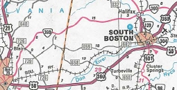
In Sep 1982 (CTB), US 360 was rerouted to run to Danville via South Boston instead of Halifax. This was accomplished by replacing VA 304 and duplexing with US 58 west of South Boston. Virginia requested to AASHTO that the old path via Halifax be labeled as US 360 ALT but for unknown reasons was denied. The old route through Halifax became VA 360.
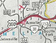
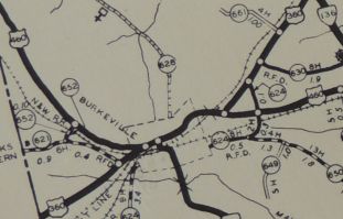
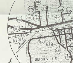
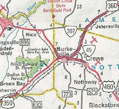
Also around 1966, US 360 received its modern routing through eastern Amelia County leaving behind Mt. Olive Ln and SR 698. In Nov 1969 (CTB), US 360 was placed on the Burkeville Bypass, leaving behind US 360-460 Business.
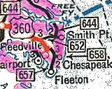
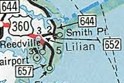
Adjustments:In July 1939 (CTB), it appears US 360 was put on its modern routings at Avalon and Blantons Corner, leaving behind SRs 694 and 695. In August 1941 (CTB), it appears US 360 was placed on its modern routings in Lilian and Beverleyville. In Sept 1948 (CTB), it appears US 360 was put on its modern routing at the northern end of Reedville, leaving behind SR 726. In Aug 1951, the CTB turned down the request of Northumberland County to make SR 657-677 a primary route. This almost certainly would've been an extension of US 360. In May 1954 (CTB), US 360 east was truncated 0.43 miles from the Reedville waterfront to its current end at SR 644.
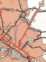
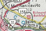
In Nov 1976 (CTB), US 360 was rerouted onto its current alignment through Indian Field, leaving behind SR 697. Improvements: The entirety of US 360 was paved upon its designation in July 1933. The first multilaning of US 360 occurred in 1953, from the WCL of Richmond (near VA 161) west to SR 647 In 1955 the 4-laning was extended west to around SR 653. In 1956, the 4-laning was extended west again to near SR 621; a 4-lane segment appeared east of Jetersville; another appeared just east of the Appomattox River. In 1957, 4-laning was extended west to SR 621; also the Appomattox River segment was extended west to VA 153. In 1958, 4-laning was extended west again to SR 603. In 1960 or 1961, US 360 was 4-laned from the Pamunkey River to Manquin and also on the US 17 duplex. In 1962, US 360 was 4-laned from US 15 north of Keysville to Meherrin. In 1963, US 360 was 4-laned from Pamunkey River west to past SR 627; also US 360 was shown 4-laned from around VA 47 south to Wyliesburg In 1964 US 360 was made multilane from SR 603 west to the Appomattox River piece; also it is incorrectly shown to be widened across the Rappahannock River; also, the VA 47 area widening was rescinded on the map. In 1965, US 360 was widended from SR 627 to nearly Mechanicsville. In 1966, US 360 was 4-laned from VA 153 to the west end of the Amelia bypass; also the Keysville bypass; also from near Clover to VA 344; also US 360 was widened from Manquin to Aylett. In 1967, US 360 was 4-laned from Amelia CH to VA 307, encompassing the stray Jetersville piece; US 360 was 4-laned from Keysville to Wyliesburg In 1968, US 360 was 4-laned on the new Mechanicsville Bypass; also from Aylett to VA 14; also from the Rappahannock River to Warsaw; also from VA 307 to Burkeville In 1969, US 360 was 4-laned when the new section bypassing Barnes Corner and Clover opened. In 1970, US 360 was 4-laned from Mechanicsville to I-64; also from VA 14 to Millers Tavern; also the BUrkeville bypass. In 1972, US 360 was 4-laned from Millers Tavern to US 17. In 1973, US 360 was multilaned from Mosby Av south to Broad St; also from Meherrin to Burkeville. In 1976, US 360 was 4-laned from Warsaw to Northumberland County. In 1977, US 360 was multilaned from SR 640 through Burgess to Lillian. In 1979, officials finally stopped showing the Rappahannock River bridge as multilane. In 1982, US 360 was made multilane from VA 344 to Danville by virtue of its rerouting, except from VA 34 south to US 58. In 1983 or 1984, US 360 was 4-laned from Richmond County to Callao. In 1988, US 360 was widened from I-64 to Mosby Av In 1990, US 360 was widened from Callao to Lottsburg. In 1993 or 1994, US 360 was 4-laned from Lottsburg to Heathsville In 2006, US 360 was 4-laned from VA 34 to US 58. US 360 is multilaned everywhere except central Richmond; Rappahannock River bridge; eastern Northumberland County US 360 has substantial sections of 6 or more lanes: I-64 to Mechanicsville Bypass; VA 150 west to Genito Rd. Posted: Fully posted; the last known cutouts were in South Richmond, removed around 2004. Cutouts in Northumberland County were removed about 1997. Multiplexes: US 58 Bus (1.76 mi) US 58 (27.80 mi) US 15 (15.88 mi) US 460 (1.68 mi) US 60 (0.38 mi) US 17 (2.44 mi) VA 3 Bus (0.78 mi) Legislative names: A.L. Philpott Memorial Highway, from Danville to South Boston (since 3/3/92); James D. Hagood Memorial Highway, from ECL South Boston to Charlotte County Line (since 4/3/90); J.E.B. Stuart Highway, from VA 344-360 to VA 92 Clover (3/14/28 designation predates US 360); James Madison Highway, on US 15 duplex (3/19/28 designation predates US 360); Patrick Henry Highway, from Keysville to SR 606 Mechanicsville, except US 360 Business segments (2/18/28 designation predates US 360); George Washington Memorial Highway, from Tappahannock to Warsaw (3/14/28 designation predates US 360) Other names: River St/South Boston Rd (Danville); Philpott Rd (Danville to South Boston); Bill Tuck Hwy/John Randolph Blvd (South Boston); Kings Hwy (Charlotte County); East Patrick Henry Hwy (Burkeville to Amelia County); Hull Street Rd (Chesterfield County); Hull St/Mayo Bridge/14th St/Main St/18th St/Balding St/17th St/Fairfield Way (Richmond); Mechanicsville Tpk (Richmond to King William County); Richmond-Tappahannock Hwy (King William County); Richmond Hwy (King and Queen County and Essex County west of US 17); Tappahannock Blvd/Queen St (Tappahannock); Richmond Rd (Tappahannock to VA 202); Northumberland Hwy (Callao to Reedville); Main St (Reedville) John Randolph Bridge over Dan River, 10/16/51 designation predates US 360; Thomas J Downing Bridge over Rappahannock River, since 5/13/38 Scenic Byway: Northumberland SR 657 to Reedville (3/3/92) Comment: US 360 is a fast paced corridor through the south central areas of Virginia. US 360 has a 60 mph speed limit nearly continuously between South Boston and Skinquarter. | |||||||||||||||||||||||
Previous: US 340 |
Next: US 401
US 60 | US 460
Top | Virginia Hwy Index
Home
Page last modified 12 March 2022