ROUTE LOG
TN STATE LINE: 0 - 0
US 11E SB, US 19 SB, VA 381 SB: 0.50 - 0.50
VA 113: 0.39 - 0.89
US 11, US 11E END, US 11W BEGIN, US 19 NB, VA 381 NB: 0.19 - 1.18
US 11W SB: 1.12 - 2.30
I-81 (exit 1), US 58 EB: 1.01 - 3.31
Washington-Bristol Line: 0.50 - 3.81
Scott-Washington Line: 6.24 - 10.05
VA 224: 17.42 - 27.47
US 23 SB: 0.32 - 27.79
US 23 Bus, US 58 Bus, US 421 Bus: 1.04 - 28.83
US 23 Bus, US 58 Bus, US 421 Bus: 2.67 - 31.50
VA 65: 9.55 - 41.05
US 23 NB: 4.67 - 45.72
Lee-Scott Line: 4.75 - 50.47
US 58 WB: 6.00 - 56.47
US 58 ALT EB: 5.21 - 61.68
US 58 ALT WB: 0.40 - 62.08
VA 352: 2.95 - 65.03
KY STATE LINE: 4.55 - 69.58
|
|
Creation: Appeared nationally in 1930 but didn't arrive in Virginia until June 1932, running from Bristol to Cumberland Gap as a replacement for US 321 and US 411 (also an addition to VA 10).
US 411 #1 appears in 1926
1926 Official
US 421 replaces US 411
1932 Texaco (Rand McN)
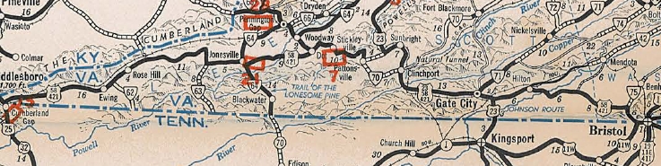
Here is a detailed look at US 421's original routing:
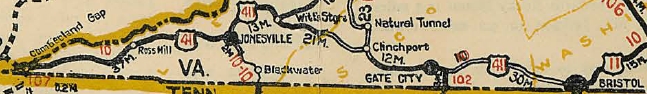
It ran from US 25E Cumberland Gap to US 11 Bristol:
US 421 in what is now 0.20 miles west of the parking lot for the Cumberland Gap area, then an unnumbered road (National Park Rd) that parallels the modern US 58 to the north eastward. The route used the SR 912 loop, then maybe modern US 58 but there is what looks like an old alignment on satellite photo that is not a road today.
US 421 used SR 732 through the old Gibson Station area, then the piece of SR 692 that is north of US 58. THe route may have followed modern US 58 over to Wheeler, then SR 729. The route then seems to have followed modern US 58 to Kesterson Mill.
US 421 followed SR 684 routing south of US 58, then followed US 58 BUsiness through Ewing. The route likely used SR 697 and SR 672 to go to Rose Hill.
US 421 followed modern US 58 until SR 670, then used the SR 813 loop to Henegartown. The route used a small bit of SR 621 and all of SR 814 in the Russels Store area. Continuing east the route used SR 946 (except used the SR 815 loop), then SR SR 899 and SR 880 down to Cony Hollow.
US 421 followed modern US 58 from here to Jonesville except used the SR 836 and SR 745 loops. Then the route followed US 58 ALT north of Jonesville to Ben Hur except it likely used SR 715, 716, and 760, plus it looks like some alignments have been destroyed.
In Ben Hur the route likely used some SR 645 and SR 644 then modern 58 ALT to Sulphur Springs, where the route probably used Combs Rd to Pennington Gap. The route in Pennington Gap seems to have been modern 58 ALT, then current US 421 south of town. The route then seems to have used a bit of SR 630 plus a dead end alignment back to today's US 421. The route used SR 785 into Woodway.
US 421 used SR 785 back to US 421, then followed that to US 58, US 421 used SR 915 up Wallen Ridge and US 58-421 off Wallen Ridge, then SR 702 to Stickleyville. Then US 421 used US 58-421 over Powell Mountain, then headed south on SR 638 through Pattonsville and down to SR 600. US 411 picked up SR 600 east to Clinchport, using SR 882, abandoned routing, SR 883 and VA 65 west.
US 421 then followed US 23-58-421 past Speers Ferry, then used SR 870 to Gate City. US 421 followed Bus 23-58-421 through Gate City, then picked up mainline US 23-58-421. Before Weber City, US 421 veered off at today's SR 619. This road used to be continuous over to today's US 58-421 east of VA 224 but it is now a VDOT maintenance yard.
US 421 followed current US 58-421 east of Hiltons to Bristol, where it followed State St to Pennsylvania Av to dip into Tennessee.
Note that per a 9/15/32 letter from Virginia to AASHO saying May 1932 changes will not be signed in the field until the base map can be revised (which turned out to be July 1933), US 411 signs may have been directly replaced in the field by US 58 signs.
Adjustments:In May 1933 (AASHO), US 421 was truncated to Bristol, replaced by US 58. US 421 only existed in Virginia on State St WB between US 19 Anderson St and Pennsylvania Ave.
US 58 quickly replaces US 421
1933 Official
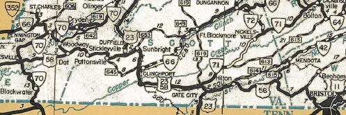
In 1935, VDOH maps show US 421 was re-extended to Cumberland Gap as a duplex with US 58. This time US 421 ran direct between Jonesville and Stickleyville.
US 421 joins forces with US 58
1936 Official
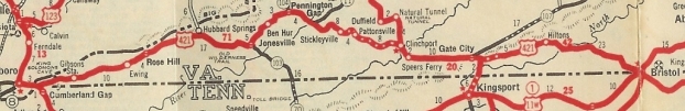
In March 1944 (AASHO), US 421 was again truncated to Bristol, leaving behind US 58. In Virginia's request VDOH expresses surprise that US 421 was co-routed with US 58 to Cumberland Gap. This is odd because state official maps from 1935-44 explicitly show this as does the 1941 route log (but not 1933 or 1935). However, the March 1935 publication of AASHO US Routes does have US 421 going to Cumberland Gap. My speculation is that AASHO did not correctly interpret Virginia's request regarding US 58 which was to cancel US 421 in Virginia. As this 1938 photo shows, US 421 was not posted at Cumberland Gap.
US 421 cut back to Bristol again
1946 Official
In June 1949 (AASHO), US 421 was re-extended along US 58 to Dot, then replaced VA 66 northwest through Pennington Gap to Kentucky.
US 421 extended to Kentucky
1950 Official
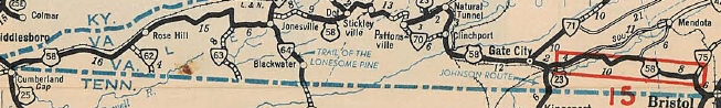
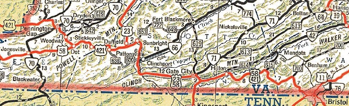
In Feb 1951 (CTB), US 421 was removed from SR 706 Main St in Pennington Gap, plus a bit of VA 70 (now US 58 ALT) and put on its current routing north of US 58 ALT.
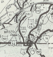
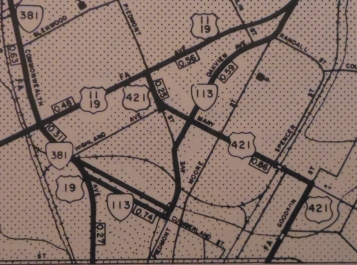
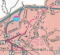
In May 1952 (CTB), US 421 was placed on split alignments in Bristol. NB continued to use State Ave all the way. SB left State Ave on 9th (now Volunteer Pkwy) south to Shelby east to 4th (now Martin Luther King Jr. Blvd) north back to State to continue over to Pennsylvania Ave as before. So some of US 421 SB dipped back into Tennessee.
In Oct 1966 (CTB), US 23-58-421 was placed on a newly constructed bypass of Gate City, leaving behind US 23-58-421 Business.
In Dec 1966 (CTB), US 421 was rerouted in Bristol by being removed from State St into central Bristol. Instead it replaced VA 76 along Goodson St to Mary St, then replaced VA 76Y along Mary St and Piedmont St, then was added to US 11-19 south along Euclid.
In Oct 1984 (CTB), US 421 was moved onto this routing through Bristol: Commonwealth south then cut east on Goode, north on Piedmont, east on Cumberland, south on Martin Luther King Jr, then east on State to Pennsylvania Ave.
US 421 Bristol (1952-66)
1961 Washington County
|
US 421 Bristol (1967-84)
1975 Washington County
|
US 421 in Bristol (1985-2011)
1988 Official
|
In Jan 1970 (CTB), US 23-58-421 was placed on newly constructed road west of Gate City, leaving behind SR 870.
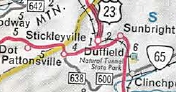
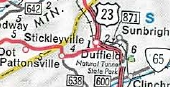
In Feb 1970 (CTB), US 23-58-421 was placed on a new alignment (partially over SR 646) between Clinchport and Duffield, leaving behind SR 871, SR 883 and a bit of VA 65.
In Aug 1972 (CTB), US 58-421 was placed on newly constructed road to avoid Pattonsville and run directly to US 23 Duffield. This left behind a bit of SR 638 and some SR 604.
US 421 initial route
1969 Official
|
US 421 avoids Sunbright
1971 Official
|

US 421 avoids Pattonsville
1974 Official
|
In March 1994 (CTB), US 58-421 was put on its current routing over Wallen Ridge west of Stickleyville, leaving behind SR 915.
In 2011, US 421 was rerouted in Bristol to stay with US 11E-19 south into Tennessee, leaving behind several city
streets.
Improvements: Upon designation, US 421 was fully paved except for Stickleyville west to Lee County Line.
Everything that was designated US 421 from 1933 onward has been paved.
The earliest multilaning of US 421 was in 1951, from Gate City to Weber City.
In 1966, US 421 was multilaned through Bristol except for Goode and Piedmont Sts.
In 1969, US 421 was widened on the new Gate City Bypass plus several miles west.
In 1970, US 421 was widened on the Sunbright bypass.
In 1971, US 421 was multilaned on the gap between Sunbright to Gate City.
By 1988, US 421 was multilaned from I-81 to US 11W.
In 2011, US 421 was multilaned on its new route south of Goode St Bristol.
Posted: Fully posted; last known cutouts were in Bristol, removed in early 2000s
Multiplexes: US 11E, US 19, VA 381 (1.18 mi)
US 11W (1.12 mi)
VA 122 (1.71 mi)
US 58 (includes triplex) (53.16 mi)
US 23, US 58 (17.93 mi)
US 58 ALT (0.40 mi)
Legislative names: Sgt. Ross S. Carter Memorial Bridge over N. Fork River (since 3/15/01);
Other names: Commonwealth Ave/Euclid Ave (Bristol) ; Gate City Hwy (Washington Co); Bristol Hwy (Scott Co e of VA 224); Hilton Rd (Weber City); Daniel Boone Heritage Hwy (US 23 multiplex w of Gate City); Duff Pat Hwy (Scott Co w of US 23); E. Morgan Ave (Pennington Gap)
Scenic Byway: Dot to Weber City (since 3/8/93); Kentucky Line to Pennington Gap (since about 2008)
Comments: US 421 should be the Hokey Pokey Hwy, as Virginia put US 421 in, put US 421 out, put US 421 in, and they shook it all about. Seriously, I have no idea what the thought process was with this route.
When I completed driving US 421 from Pennington Gap to Dot in 2010, that finished the primary system in Virginia for me.
|