< VA 47 | Home | VA 49 >
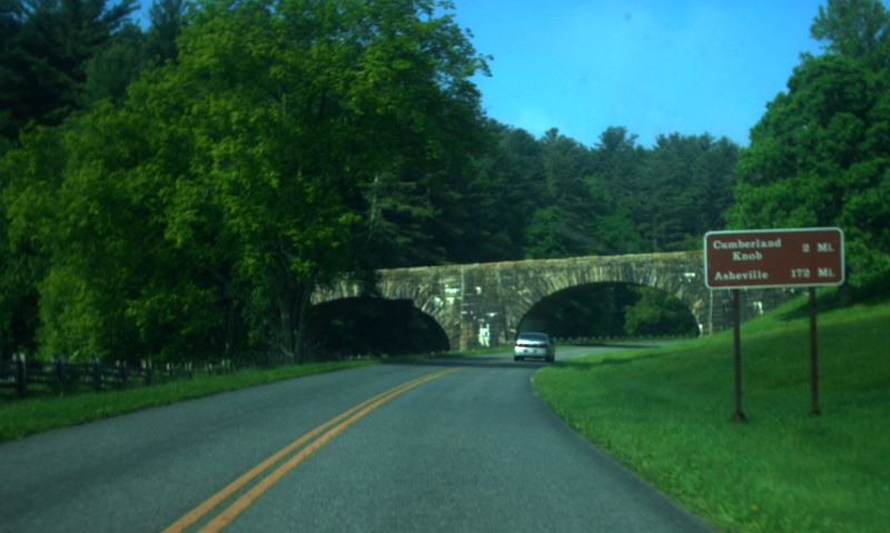
Photo: VA 48 south at the VA 89 overpass (photo by Mapmikey 5/25/12)
|
.
|
|
| ROUTE LOG |
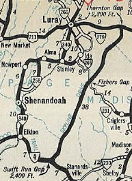
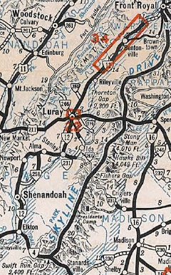
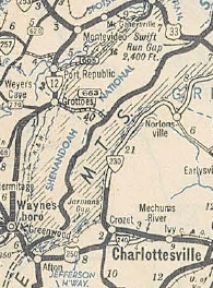
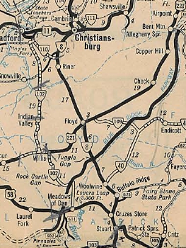
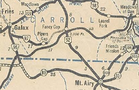
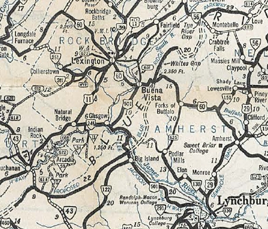
US 340, Skyline DR BEGIN: 0 - 0 Raapahannock-Warren Line: 10.47 - 10.47 Warren-Rappahannock Line: 3.87 - 14.34 Raapahannock-Warren Line: 1.69 - 16.03 Page-Rappahannock Line: 5.92 - 21.95 Rappahannock-Page Line: 2.09 - 24.04 Page-Rappahannock Line: 4.41 - 28.45 US 211: 3.01 - 31.46 Rappahannock-Page Line Line: 0.06 - 31.52 Madison-Rappahannock Line: 4.99 - 36.51 Page-Madison Line: 14.77 - 51.28 Rockingham-Page Line: 7.77 - 59.05 Greene-Rockingham Line: 2.53 - 61.58 Rockingham-Greene Line: 1.33 - 62.91 US 33: 2.69 - 65.60 Greene-Rockingham Line: 0.10 - 65.70 Rockingham-Greene Line: 1.01 - 66.71 Greene-Rockingham Line: 1.93 - 68.64 Rockingham-Greene Line: 1.33 - 69.97 Greene-Rockingham Line: 3.26 - 73.23 Rockingham-Greene Line: 2.08 - 75.31 Albemarle-Rockingham Line: 8.44 - 83.75 Augusta-Albemarle Line: 3.65 - 87.40 US 250, Blue Ridge Pkwy BEGIN, Skyline Dr END: 18.17 - 105.57 Nelson-Augusta Line: 15.97 - 121.54 VA 56: 11.09 - 132.63 Rockbridge-Nelson Line: 0.08 - 132.71 US 60: 18.29 - 151.00 Amherst-Rockbridge Line: 0.15 - 151.15 VA 130: 15.86 - 167.01 Bedford-Amherst Line: 2.38 - 169.39 US 501: 0.19 - 169.58 Botetourt-Bedford Line: 10.61 - 180.19 VA 43 SB: 11.28 - 191.47 Bedford-Botetourt Line: 3.11 - 194.58 VA 43 NB: 1.80 - 196.38 Botetourt-Bedford Line: 2.18 - 198.56 US 221, US 460: 12.72 - 211.28 Roanoke-Botetourt Line: 2.97 - 214.25 VA 24: 3.64 - 217.89 US 220: 10.31 - 228.20 Floyd-Roanoke Line: 14.69 - 242.89 US 221: 0.03 - 242.92 Franklin-Floyd Line: 16.05 - 258.97 Floyd-Franklin Line: 1.51 - 260.48 VA 8: 11.62 - 272.10 Patrick-Floyd Line: 5.23 - 277.33 Floyd-Patrick Line: 0.88 - 278.21 Patrick-Floyd Line: 5.92 - 284.13 US 58 Bus: 0.42 - 284.55 Carroll-Patrick Line: 6.33 - 290.88 US 52: 15.59 - 306.47 Grayson-Carroll Line: 12.75 - 319.22 VA 89: 3.56 - 322.78 NC STATE LINE: 1.13 - 323.91
|
Creation: Appeared Oct 1934 as the right of way designations for both the Skyland Drive (now Skyline Dr) and Blue Ridge Parkway. This is the 2nd VA 48.
| Adjustments: The first piece of VA 48 to open was Skyland Drive from VA 4 (now US 33) Swift Run Gap to US 211 Thornton Gap in Oct 1934. This segment is shown as complete but "closed to traffic" on the July 1933 Official. In 1935, what was now termed Skyline Drive was opened from US 211 to VA 12 (now US 340) below Front Royal. Dotted lines began showing for the Blue Ridg Parkway in Virginia in 1936, from Adney Gap to south of Meadows of Dan. In 1937, the full length of the Blue Ridge Pkwy and the southern third of Skyline Dr were shown as dotted lines. In 1938, the Blue Ridge Pkwy opened from US 221 connector Adney Gap south to below US 58 Meadows of Dan. In 1939, Skyline Drive was extended south from US 33 to US 250 Afton Mtn.
Also in 1939, the Blue Ridge Pkwy was extended south to North Carolina.
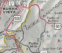
In 1941, 3 more segments of the Blue Ridge Pkwy were open: 1. SR 814 Love south to VA 56 2. several miles from US 60 northward 3. a few miles south of VA 43/SR 695 to US 501. Part of this was a replacement of VA 43, which was conveyed to the National Park Service in Oct 1938. Between 1942-44, pieces 1 and 2 above were connected and the third piece was extended south to US 460.
In 1946, the Blue Ridge Pkwy was opened from US 250/Skyline Dr south to SR 814. Between 1960-61, the Blue Ridge Pkwy was opened from US 501 to US 60. In 1963, the Blue Ridge Pkwy was opened from Adney Gap north to US 220. In 1966, the final segment of the Blue Ridge Pkwy in Virginia was opened from US 220 to US 460.
Improvements: Fully paved upon segments opening except: US 60 to US 250 is shown as paved starting 1950. US 460 to US 60 is shown as paved starting in 1953. VA 48 has no multilane segments. Posted: Fully posted; Multiplexes: VA 43 sort of (4.91 mi) Legislative names: None Other names: Blue Ridge Pkwy (NC to US 250); Skyline Drive (US 250 to US 340) Scenic Byway: All of this is a National Scenic Byway Comment: VA 48 is prohibited for all commercial traffic. VA 48 is only referenced about 3 times in the CTB minutes as part of the Blue Ridge Pkwy, all in reference to land conveyances after the fact. VA 48 does not show on any printed map I have ever seen from Virginia, but it DOES show on the on-line interactive map at www.virginiadot.org The Skyline Drive portion of VA 48 has no at-grade intersections with any through road south of US 340 - only interchanges at US 250 and US 33. The Blue Ridge Pkwy has interchanges at all its primary route intersections except US 221 Adney Gap and the two VA 43 intersections. However, there are numerous secondary route at-grade intersections. A lot of these are unpaved, making the "No commercial vehicles" postings at those locations seem a little comical. VA 48 crosses but does not intersect four primary routes in Virginia: I-77, US 58 Bypass, VA 116, and I-64. Only the VA 116 crossing has no easy, nearby way to make a connection. The speed limit on the Skyline Drive is mostly 35 and on the Blue Ridge Pkwy is mostly 45. Other than peak fall color season, these routes work okay as through routes, though services on VA 48 itself are quite limited. The Skyline Drive portion requires a fee as part of entry into Shenandoah National Park. This in effect makes VA 48 through there the longest toll road in Virginia. | Previous VA 48's:
1933 ROUTE LOG US 15, US 360: 0 - 0 VA 49 SB: 14 - 14 VA 49 NB, VA 136 NB: 3 - 17 VA 136 SB: 3 - 19 VA 34: 4 - 23 VA 137: 10 - 33 US 460 WB: 1 - 34 US 460 EB: 1 - 35 US 1 SB: 20 - 55 US 1 NB: couple blocks - 55 Sussex-Dinwiddie Line: 12 - 67 GAP IN ROUTE Sussex-Dinwiddie Line: 0 - 67 US 301 NB: 6 - 73 US 301 SB: 1 - 74 VA 32: 6 - 80 VA 35: 10 - 90 US 460: 8 - 98 VA 10: 12 - 110 SR 609: 5 - 115 |
VA 48 #1: Began in Aug 1928 (CTB) as 4 pieces:
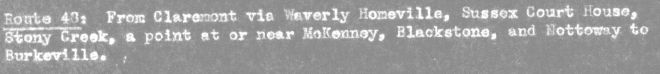
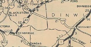
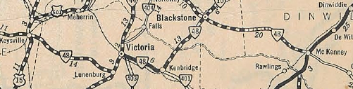
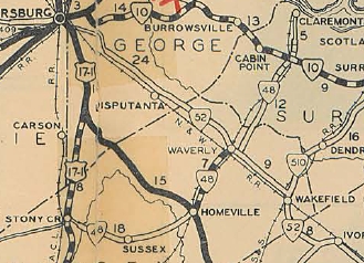
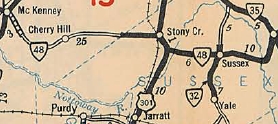
1. A renumbering of VA 323 running from VA 401 (now VA 137-138) Kenbridge northeast to US 460 Blackstone; newly designated routing from Blackstone east to the Dinwiddie Line. 2. new routing US 1/VA 31 McKenney west 12.8 miles towards Blackstone. 3. new routing from US 17-1/VA 24 (now US 301) near Stony Creek east to Sussex CH, then replacing VA 351 from Sussex CH to VA 52 Waverly. 4. new routing from the Surry-Sussex Line east 10.4 miles through VA 10 Spring Grove towards Claremont. In Aug 1929 (CTB), piece 1 was connected to piece 2. In March 1930, VA 48 was extended west from Kenbridge over VA 401 to Victoria, duplexed with VA 44 to Lunenburg CH, then replaced VA 47 west to end at US 15-501/VA 32 Keysville.
In June 1930 (CTB), piece 3 was extended north with US 17-1 a mile, then west 0.3 miles as new routing to Stony Creek. Also, piece 4 was extended 0.84 miles west into Sussex County. In Dec 1930 (CTB), after a brief added duplex to US 1, piece 1-2 was extended east 2.7 miles as new routing out of McKenney. Also, piece 3 was extended west 5 miles to the Dinwiddie line. Also, piece 4 was extended esst to Claremont (current SR 609-613 traffic circle), and west 1.9 more miles west to Waverly, connecting to piece 3. In July 1932 (CTB), piece 1-2 was extended east 7.4 more miles towards Stony Creek.
The 1933 draft route log had VA 48 west rerouted at Blackstone to replace VA 10 to end at US 221 (really) Burkeville. VA 48 from Blackstone to Keysville would've become part of VA 10.
VA 48 reroute to Burkeville planned 1933 draft route log In Aug 1933 (CTB), piece 1-2 was extended east to the Sussex County Line. In Oct 1934, VA 48 was renumbered as an extended VA 40. Today it is still mostly VA 40 except: SR 775 Neblett Field Rd; Old Court St in Victoria; 2-miles of road within Fort Pickett; SR 736 west of Kenbridge; SR 614 Sunnyside Rd, US 1, and SR 713 Ragsdale St in McKenney; SRs 609/616/617/619 through Cherry Hill and Bolsters Store to Sussex Co; VA 40 Business through Stony Creek; US 301; SR 659 and abandoned routing across the Nottoway River; SR 634 through Sussex CH and beyond VA 35; SR 606 Beaver Dam Rd east of Waverly; SR 646 from Spring Grove to Claremont; SR 613 to SR 609 | ||||||||||||||||||||
Previous: VA 47 |
Next: VA 49
Top | Virginia Hwy Index
Home
Page last modified 27 March 2022