< US 13-A | Home | US 17 >
US 15 Business | US 15 ALT
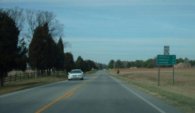
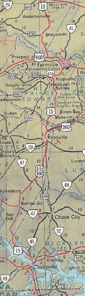
Photo: US 15 north of Keysville (photo by Mapmikey 2/15/08)
|
|
|
| ROUTE LOG |
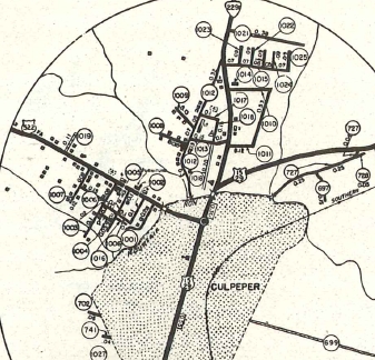
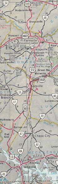
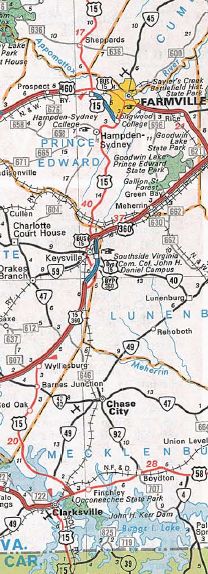
NC STATE LINE: 0 - 0 US 58, VA 49: 5.35 - 5.35 US 58 Bus WB: 0.73 - 6.08 US 58, US 58 Bus END, VA 49 SB: 1.72 - 8.80 VA 49 NB: 1.60 - 10.40 Mecklenburg-Charlotte Line: 6.83 - 17.23 VA 92: 7.39 - 24.62 US 360 WB: 3.24 - 27.86 VA 47: 3.88 - 31.74 US 15 Bus, US 360 Bus: 6.60 - 38.34 US 15 Bus, US 360 Bus: 0.80 - 39.14 VA 40: 2.56 - 41.70 US 15 Bus, US 360 EB, US 360 Bus: 2.04 - 43.74 Prince Edward-Charlotte Line: 1.66 - 45.40 VA 133: 12.14 - 57.54 US 15 Bus, US 460 EB: 2.94 - 60.48 US 460 WB, US 460 Bus BEGIN: 4.18 - 64.66 US 15 Bus, US 460 Bus EB: 0.14 - 64.80 Buckingham-Prince Edward Line: 1.77 - 66.57 US 60: 14.76 - 81.33 VA 20: 1.45 - 82.78 Fluvanna-Buckingham Line: 16.35 - 99.13 VA 6 WB: 4.54 - 103.67 VA 6 EB: 1.99 - 105.66 VA 53: 6.36 - 112.02 Louisa-Fluvanna Line: 8.69 - 120.71 US 250: 0.03 - 120.74 I-64 (exit 136): 0.45 - 121.19 VA 22: 6.95 - 128.14 US 33 EB: 4.43 - 132.57 Orange-Louisa Line: 0.45 - 133.02 US 33 WB, VA 231: 1.12 - 134.14 VA 20 NB: 8.35 - 142.49 VA 20 SB: 0.17 - 142.66 VA 20 Bus: 0.24 - 142.90 Madison-Orange Line: 3.03 - 145.93 VA 230: 0.39 - 146.32 Culpeper-Madison Line: 4.92 - 151.24 VA 299: 7.85 - 159.09 US 15 Bus, US 29 SB: 0.82 - 159.91 US 522, VA 3: 1.32 - 161.23 US 15 Bus, US 29 Bus: 3.88 - 165.11 US 15 Bus, US 29 Bus: 6.96 - 172.07 Fauquier-Culpeper Line: 0.24 - 172.31 US 15 Bus, US 29 Bus: 2.17 - 174.48 VA 28: 0.30 - 174.78 US 17 SB: 4.00 - 178.78 US 15 Bus, US 17 Bus, US 29 Bus: 4.71 - 183.49 US 17 NB: 2.44 - 185.93 US 15 Bus, US 29 Bus: 0.36 - 186.29 VA 215: 6.70 - 192.99 Prince William-Fauquier Line: 0.13 - 193.12 US 29 NB: 0.82 - 193.94 VA 55: 2.77 - 196.71 I-66 (exit 40): 0.16 - 196.87 VA 234: 3.89 - 200.76 Loudoun-Prince William Line: 4.25 - 205.01 US 50: 2.58 - 207.59 US 15 Bus, VA 7 WB: 10.54 - 218.03 VA 267: 0.44 - 218.47 VA 7 EB, VA 7 Bus: 1.16 - 219.63 US 15 Bus: 2.52 - 222.15 WV STATE LINE: 9.97 - 232.12
|
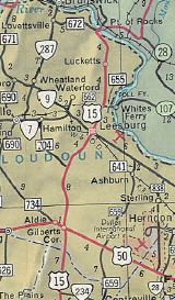
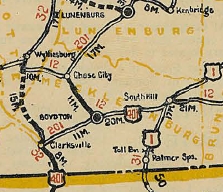
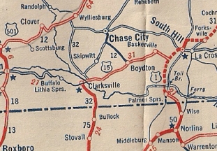
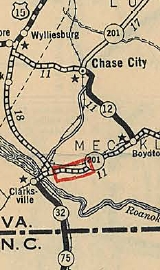
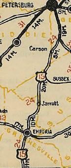
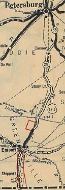
Creation: Appeared in November 1926, running from tne NC line north to Clarksville, then east to end at US 1 (now Goodes Ferry Rd) South Hill. This had been shown as | In March 1927 (AASHO), US 15 was rerouted at Clarksville with VA 32 north to Maryland at Point of Rocks. There had been a push by outside organizations to make this part of US 9. The route from Clarksville to South Hill became US 401. Today this is US 58 Business and US 58 east of Clarksville; SR 783 through Finchley; SR 756 into Boydton; one block of SR 707 north. US 401 then followed VA 12 where it followed US 58 Business east to about the mainline US 58. VA 12 initially followed a road now abandoned save a small piece of SR 608 Ridge Rd that follwed the RR tracks closely (north side) until about the current US 58-VA 4 jct. VA 12 followed "Old Plank Rd" from here which is now SR 674 to Baskerville; SR 669 to SR 668 to SR 663 to SR 645 to SR 644 to SR 661 Lombardy Grove; SR 661 to South Hill. US 401 ended at today's Goode Ferry Rd (SR 903), which at that time was US 1/VA 31. Here is a detailed look at US 15's 1927 routing: US 15 initially began where today's SR 822 enters Virginia from North Carolina near Soudan. SR 822 ends at Buggs Island Lake and US 15 would've continued north. Driveable road picks up again with SR 821 Old National Hwy at the Merifield Wildlife Management Area. Alas, SR 821 ends at another arm of the lake. US 15 picked up SR 1102 5th St on the other side into Clarksville. As far as I can tell, US 15 headed east on today's US 58 Business and crossed the Roanoke River in about the location of today's lake crossing. US 15 then picked up current US 15 to Bluestone Creek, then used these loops along US 15 to the Charlotte County line: SR 857 Mooresville Rd; SR 858 Oak Hill Dr; SR 859 Whitetail Rd; SR 700 Turkey Rd. In Charlotte County, US 15 used current US 15 north to Wyliesburg, then US 15-360 northeast. A little past SR 628, US 15 veered more northerly on abandoned routing, then picked up SR 713 Deuprees School Rd to VA 47, then Woodland Ln and Ferraro Ln northeast back to 15-360. After Walkers Store, US 15 used SR 622 Old Kings Rd, then US 15-360 Business through Ontario. US 15 used 15-360 Business through Keysville except I believe it used SR 629 Southern Dr south of VA 40. US 15 picked up current US 15 north of town into Prince Edward County. US 15 more or less followed US 15 to Farmville except for a couple abandoned loops and SR 630/677 loop through Redd Shop. US 15 exited Farmville west along High St/Buffalo St over to US 15 Business. US 15 used the lengthy SR 695 over to Dowdy's Corner before heading north on US 15 to Buckingham County. US 15 followed today's US 15 north except used SR 689 loop near Sheppards; abandoned loop south of Curdsville; SR 600 loop; abandoned loops at Willis Mtn and north of SR 686; SR 750 Mingo Ln north of Sprouses Corner. In Dilwyn, US 15 followed current US 15 except SR 1010 Gold Mine St. US 15 followed today's US 15 to the James River except it used SR 715 Circle Drive Rd and SR 796 Old 15 Rd. At New Canton, US 15 used SR 670 Banks Family Rd, then SR 687 Boat Landing Ln to the James River. US 15 crossed the James and continued north on SR 657 Bremo Bluff Rd. It is possible US 15 used SR 666 and somehow connected back to US 15 further north but I cannot prove it. Otherwise, US 15 used current US 15 to Fork Union and Dixie. North of VA 6, US 15 followed 15 except abandoned old SR 691 loop; abandoned loop at Carys Creek; SR 673/649 loop at Fluvanna County High School; abandoned loops on both sides of 15 north of SR 649; US 15 used current 15 to near VA 53 but then ran on an alignment a little further west to cross the Rivanna River directly to SR 1001 Main St through Palmyra. North of Palmyra, US 15 used today's US 15 except: SR 632/661 loop; SR 644 Friendship Rd; abandoned old SR 644 loop just south of SR 613; SR 644 Salem Church Rd/Poorhouse Ln (no longer connects back to US 15). Approaching Gordonsville, US 15 veered across the railroad (closed now) to use SR 729 S. Main St back to US 15-33 through town. US 15 then headed north on current US 15 except it used the SR 686 Thoroughbred Rd now-only-half-a-loop. Near Madison Run, US 15 veered northeast through the Orange Livestock Market to connect directly to SR 647 Old Gordonsville Rd which US 15 followed to Orange. US 15 used today's US 15, then VA 20 south, then VA 20 Business north back to US 15 to negotiate through Orange. North of town, US 15 used today's 15 except SR 721 Bennetts Ford Rd; SR 723 Petersburg Rd; abandoned loop over Rapidan River using a bit of SR 659. In Madison County, US 15 followed modern 15 except at Locust Dale it used SR 634 northwest, then abandoned road back east to 15 and Culpeper County. US 15 ran west of US 15 on what is now abandoned road from the Robinson River to SR 721, then used SR 721 White Oak Rd, SR 648 Cedar Ridge Rd; lenghty abandoned alignment along the tree line west of today's US 15; a section of SR 657 General Winder Rd; abandoned routing across US 15 to connect with SR 692 (at SR 649 jct) Old Orange Rd. US 15 followed SR 692 for quite a distance before connecting back up with US 15 in the VA 299 area. US 15 followed US 15 Business into Culpeper but continued past VA 3 on Orange Rd directly to Main St. US 15 used Main into central Culpeper, then used Piedmont St east to Clay St which turns into Old Brandy Rd. US 15 followed this out to US 15-29 Bus, then at the current Bypass veered over to SR 684 Bel Pre Rd, then SR 663 Stevensburg Rd, then SR 700 and SR 669 Carrico Mills Rd into Brandy Station. At SR 762, US 15 headed northeast to connect to SR 685 Fleetwood Heights Rd over to Elkwood, connecting directly to SR 755 Elkwood Rd (no road does this anymore) back over to US 15-29. US 15 then veered over with US 15-29 Business and just after SR 673 veered onto abandoned alignment to cross the Rappahannock River directly to SR 1202 Willis Ave/River Rd back over to US 15-29 Business in Remington. US 15 followed 15-29 Bus to US 15-29 north to Warrenton - US 15 used US 15 Business to the courthouse, then Winchester St north to US 17 Business north out of town. US 15 followed US 17 except it used abandoned routing to the east at SR 628, then SR 860 at Cedar Run. US 15 used the SR 777 loop but it is unclear if it ever used SR 699 Merry Oaks Rd. US 15 picked up VA 245 through Old Tavern over to The Plains, then after a brief jaunt on VA 55, used SR 626 north to US 50 Middleburg. US 15 followed US 50 east through Aldie, then north on today's US 15. US 15 followed 15 except for several visible abandoned alignments plus SR 899. US 15 used US 15 Business through Leesburg, then US 15 north through Lucketts. About 1/2 mile short of the Potomac River, US 15 used a visible old alignment to the east that crossed 15 onto SR 672, then northeast to where it crossed the Potomac River into Maryland. Adjustments: In 1930, US 15 was placed on modern US 15 between Palmyra and Zions Crossroads; Madison Mills to Culpeper; modern route through Remington In 1931, US 15 was placed on modern US 15 from Madison Run to Gordonsville and also removed from Main St in Palmyra.
By 1932, US 15 was also placed on the current US 15 corridor in the James River area In July 1933, VA 32 was dropped from US 15. I cannot find a specific reference but US 15-360 was put on its modern alignment in the VA 47 area not long after 1933, leaving behind what is now SR 713. About 1935, US 15 was placed on today's SR 762 between Inlet and Brandy Station.
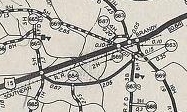
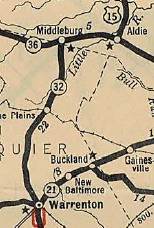
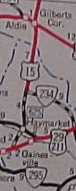
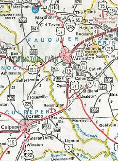
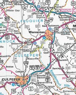
By 1936, US 15 was given its current Gordonsville routing. About 1937, US 15 was given its original bypass around Warrenton to the west, leaving behind US 15 ALT (see scan under US 15 ALT entry below). In Oct 1940 (CTB), US 15 was assigned to its current routing from Warrenton to US 50 Gilbert's Corner. However, the route itself wasn't fully constructed and thus a US 15 TEMP was assigned to the original Warrenton-The Plains-Middleburg-Gilbert's Corner Routing in the Aug 1941 CTB. The part from US 29 Buckland to VA 234 was shown as SR 625 on maps up through 1950. Present-day SR 625 near Haymarket is still unpaved.
In Nov 1940, the CTB adopted a proposal to reroute US 15 from Dillwyn to Farmville using roughly the path followed by SRs 632/634 to Browns Store, then replacing VA 45 south to Farmville. In Aug 1941 (CTB), the funding allocated to relocate US 15 from Dillwyn to Farmville was withdrawn (given to US 60 instead). My guess would've been that VA 20 would have been extended south to Dowdy's Corner had this project been completed. In April 1944 (CTB), US 15 was removed from SR 715 in northern Buckingham County In 1948, US 15 was placed on today's US 15 Business north out of Culpeper, leaving behind SR 727 (Piedmont St/Clay St/Old Brandy Rd)
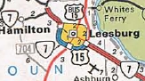
In 1950, US 15-460 was removed from the lengthy SR 695 west of Farmville. In March 1954 (CTB), US 15 was given its modern routing from Clarksville south to the North Carolina line to accomodate Buggs Island Lake, leaving behind SRs 821, 822, and 5th St. In Oct 1953 (CTB), US 15 was removed from SRs 721 and 722 north of Orange. Also in March 1954, US 15 was removed from SR 691 north of Dixie. In Jan 1956 (CTB), US 15 was removed from SRs 750 and 1010 in Dillwyn. I cannot find a specific reference but the Jan 1958 Charlotte county map shows US 15-360 on its modern alignment just south of Ontario, leaving behind an extended SR 622. In Oct 1958 (CTB). US 15 was removed from SR 649/673 loop at Fluvanna High School. In Oct 1959 (CTB), US 15 was given its modern routing approaching the Potomac River. In Jan 1960 (CTB), US 15-29 was removed from SRs 685/676 between Brandy Station and Elkwood. In April 1963 (CTB), US 15 was removed from several loops south of US 60 in Buckingham County. In June 1963 (CTB), US 15 was removed from SRs 857, 858, 859, 700 north of VA 49. In Aug 1965 (CTB), US 15 was given its bypass of Leesburg leaving behind US 15 Business. North of VA 7 is shown finished on earlier maps and was referred to as VA 599 in the CTB.
In Oct 1966 (CTB), US 15-360 was given its bypass of Ontario and Keysville, leaving behind US 15-360 Business. In Feb 1972 (CTB), US 15 was given its bypass of Farmville, leaving behind US 15 Business (some of this is unnumbered High St today). Not approved by AASHO until Nov 1975 and not shown on maps until 1976.
In July 1974 (CTB), US 15 was given its current routing through Orange, leaving behind pieces of VA 20 and VA 20 Business.
In Nov 1974 (AASHO), US 15 was given its Culpeper Bypass, leving behind US 15-29 Business. Around 1975, US 15-29 was given its modern routing from Inlet past Brandy Station to Remington, leaving behind OSR 15-29 (now SR 762) and also SRs 685/755. In Sept 1975 (CTB), US 15 was given its bypass of Remington, leaving behind US 15-29 Business. In 1986, US 15 was placed on the new freeway bypass of Warrenton around to the east. This left behind extended US 15 Business designations at both ends but the majority of mainline US 15's initial bypass became US 29 Business.
Improvements: Upon designation in 1926, US 15 was paved from the NC Line to Clarksville; Gordonsville to Madison Mills; Culpeper to the Maryland line. By late 1927, US 15 was paved from Farmville to Dowdys Corner. The other parts of US 15 were fully paved in 1931. The First segment of US 15 to be multilaned was from the Warrenton Bypass north to where it left US 29-211, in 1956. In 1963, US 15 was shown as erroneously 4-laned from US 360 split near Wylliesburg to about VA 47 (rescinded in 1964). In 1966, US 15 was multilaned on the Keysville Bypass; also from Opal to the original Warrenton Bypass In 1967, US 15 was multilaned on the rest of its US 360 overlay. In 1968, US 15 was multilaned from VA 28 to Opal. In 1971, US 15 was multilaned from Gordonsville to Orange in 1972, US 15 was multilaned on its VA 7 duplex In 1973, US 15 was multilaned on its new Culpeper Bypass In 1975, US 15 was multilaned from the Culpeper Bypass to VA 28 In 1976, US 15 was widened on its Farmville bypass By 1995, US 15 was widened about a mile north of VA 7. Main maps still don't show this while insets since the late 90s erroneously show it widened north to US 15 Business Around 2005, US 15 was 4-laned on a 3/4 mile segment a little north of I-66. About 2009, US 15 was 4-laned from I-66 to the 2005 segment In 2010, US 15 was 4-laned from the 2005 segment to VA 234. Posted: Fully posted; the last cutout I knew of on mainline US 15 was on VA 231 south of the Gordonsville traffic circle at the Truck Route divergence, removed in 2020. The one at the traffic circle was removed about 2016. Multiplexes: US 58 Bus (1.72 mi) VA 49 (1.60 mi) US 360 (15.88 mi) US 460 (4.18 mi) US 460 Bus (0.14 mi) VA 6 (1.99 mi) US 33 (1.57 mi) VA 20 (0.17 mi) US 29 (34.03 mi incl. triplex) US 17, US 29 (7.15 mi) VA 7 (1.60 mi) TRUCK Route: There is a quasi-posted US 15 Truck route through Gordonsville that uses a little VA 231 plus SR 1006 High St. Legislative names: Jefferson Davis Highway, NC Line to Clarksville (3-17-22 designation predates US 15); James Madison Highway, NC Line to Warrenton except bypasses of Keysville, Farmville, Culpeper, Remington; US 50 to MD Line except Leesburg Bypass (since 3-19-28); James Monroe Highway, US 50 to MD Line except Leesburg Bypass (since 3-4-32) John H. Cocke Memorial Bridge over James River (3-12-38); George Potter Griffin Memorial Bridge over Carys Creek (1-17-57); Pembroke Pettit Bridge over Rivanna River (3-23-32); James Lawson Kemper Memorial Bridge over Rapidan River (5-16-91); Other names: College St/Virginia Ave (Clarksville); Barnesville Hwy (Charlotte Co s of US 360); Kings Hwy (US 360 duplex); Farmville Rd/Hwy (US 360 to US 460); Prince Edward Hwy (US 340 duplex); Sheppards Rd (US 460 to Buckingham Co); Oak St/Main St (Dilwyn); Martinsburg Ave (Gordonsville); Caroline St/Madison St (Orange); Eastern Bypass (Warrenton); Lee Hwy (US 29 duplex N of Warrenton); King St/Leesburg Bypass (Leesburg) Scenic Byway: US 50 to MD Line except Lessburg Bypass (5-19-88) Comments: Despite the Clarksville bypass opening in 2006, US 15 has not been routed onto it. US 15 doesn't proceed in a corridor along with any interstates in Virginia, yet it is not a very busy corridor south of Culpeper. US 15 north of Culpeper is often traffic-choked and the scenic value it has north of US 50 is threatened by development. Virginia would like to widen US 15 north of Leesburg which is always crowded and has a reduced speed limit of 45 the entire distance to the Potomac River but is in no hurry because Maryland won't widen its side even though its stretch up to US 340 near Frederick is also busy and dangerous AND they already acquired the right-of-way a long time ago. Maps were all over the place in the 1926-28 timeframe. The 1926 Official showed the 1925 preliminary US 15 and US 401 designations; The 1927 Clasons Atlas and the 1927 Standard Drafting Maps both show the Nov 1926 designations; the 1928 Official shows no US route from Clarksville to South Hill at all.
| Previous US 15's:
|
US 15 #1: Designated in the 1925 planning for the US route system, running from US 1 Petersburg south with VA 35 to Templeton, then south with the entirety of VA 24 through Emporia to the North Carolina Line
On Jan 13, 1926 Virginia rejected the AASHO proposal to renumber US 15 and US 13-A. On Feb 3, 1926 US 15 was redesignated as US 17W briefly before rescinding this action in a March 13, 1926 letter making it US 15 again. However, when the official system was rolled out. the corridor was designated as US 17-1. Today it is the US 301 corridor, though most of the original route is on new alignments.
| |||||||||||||||||||||||||||||

Previous: US 13-A |
Next: US 17
US 15 Business | US 15 ALT
Top | Virginia Hwy Index
Home
Page last modified 30 September 2011