|
From:   City of Richmond City of Richmond
To:
Dead End at Stingray Pt. (Middlesex County)
Current Length: 72.24 miles
|
|
|
|
|
ROUTE LOG
US 33, US 250: 0 - 0
US 1, US 301: 0.58 - 0.58
Henrico-Richmond Line: 3.23 - 3.81
I-64 (exit 193): 0 - 3.81
VA 156: 4.87 - 8.68
VA 33Y: 1.43 - 10.11
US 60 WB, VA 156 NB: 0.15 - 10.26
I-295 (exit 28): 1.38 - 11.64
VA 156 SB: 2.24 - 13.88
New Kent-Henrico Line: 1.85 - 15.73
US 60 EB, VA 249 Begin: 0.91 - 16.64
I-64 WB (exit 205), VA 249 EB: 0.22 - 16.86
VA 106: 5.32 - 22.18
VA 155: 3.47 - 25.65
I-64 EB (exit 220): 5.69 - 31.34
VA 30 EB, VA 249: 2.98 - 34.32
VA 273: 3.50 - 37.82
King William-New Kent Line: 1.15 - 38.97
VA 296: 0.20 - 39.17
VA 30 WB: 0.05 - 39.22
VA 298: 0.05 - 39.27
King and Queen-King William Line: 0.43 - 39.70
VA 14 WB: 3.44 - 43.14
VA 14 EB: 1.66 - 44.80
Gloucester-King and Queen Line: 2.61 - 47.41
VA 374: 2.62 - 50.03
US 17 SB, VA 198: 0.30 - 50.33
Middlesex-Gloucester Line: 1.55 - 51.88
US 17 NB, US 17 Bus Begin: 0.81 - 52.69
US 17 Bus NB: 0.80 - 53.49
VA 227: 1.78 - 55.27
VA 3 WB: 5.11 - 60.38
VA 3 EB: 3.45 - 63.83
END VA 33: 8.41 - 72.24
|
|
Creation: Appeared in Sept 1937 as a renumbering of VA 4 running from Richmond to Stingray Point as a state route extension of US 33. This is the 3rd VA 33.
Current VA 33 arrives
1938-39 Official
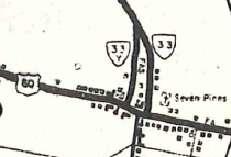
Adjustments: Between 1940-46, VA 33 was removed from the SR 627-641 Stormont Loop east of Saluda.
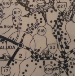
VA 33 through Stormont
1940 Middlesex County
|
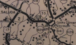
VA 33 on modern route
1940 Middlesex County
|
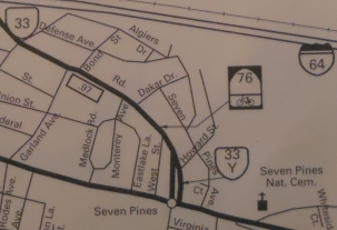
In March 1962 (CTB), VA 33 was removed from the SR 647 Batt loop in Gloucester County.
In April 1962 (CTB), VA 33 was placed on its modern alignment from VA 14 Shacklefords to the Gloucester Line, leaving behind SR 678 Shacklefords; SR 601 loop: SR 679 loop
In July 1970 (CTB), VA 33 was officially moved onto I-64 between Bottoms Bridge and eastern New Kent County. This was done by extending VA 33 further east along US 60 from the Henrico Line, then north to I-64 on new construction. From Exit 220 northeast to VA 30-249 was also new construction. The old route became: abandoned routing between US 60 and I-64; SR 674 Clint Ln; VA 249. Of course, official maps didn't show I-64 finished through here until the 1973 issue.
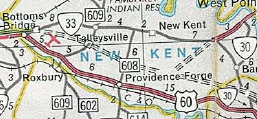
VA 33 through New Kent CH
1970 Official
|
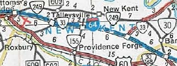
VA 33 rerouted to I-64
1975 Official
|
It is unclear where the US 33-VA 33 transition was for many years. See my US 33-VA 33 transition page which lays out all the evidence I have on where this has been over the years.
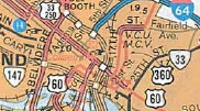
Sometime between 1960 and 1972, VA 33 west was officially truncated to end at US 360, 17th St, with US 33-250 coming from Broad St EB. The Dec 1981 CTB explicitly had US 33's eastern end at US 360 and it was now (1981) moving to the recently relocated VA 33 using Hancock/Harrison. However, postings in the field showed the transition to have been at 25th and Broad.
I believe in Aug 1976 (CTB), VA 3-33 was removed from the SR 707 loop in Grafton.
About 1979, VA 33 was removed from Old Williamsburg Rd on both sides of I-295 in Sandston.
In Sept 1981 (CTB), VA 33 was rerouted in Richmond to use the new Martin Luther King, Jr bridge over I-95, Leigh St and then the one-way splits using Hancock and Harrison Sts. This left behind an unnumbered 25th St down to Broad St and US 60 (now partly unnumbered and partly US 250) west to US 360.
VA 33 using 25th St
1980 Official
|
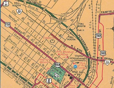
VA 33 rerouted to Leigh
1982-83 Official
|
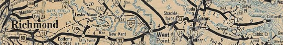
In 2006, VA 33 was moved onto a new Mattaponi River bridge, leaving behind abandoned causeway and F1000.
Around 2008, VA 30-33 was moved onto a new Pamunkey River bridge, leaving behind abandoned causeway.
Improvements: Paved upon its inception
In 1948, VA 33 was multilaned from Richmond to Highland Springs.
In 1958, VA 33 was multilaned from the Gloucester-Middlesex Line to Saluda
In 1960-61, VA 33 was multilaned from Glenns to the Middlesex Line.
In 1964, VA 33 was widened from today's VA 30-249 jct to the Pamunkey River.
In 1970, VA 33 was multilaned from the Henrico-New Kent line to I-64, plus it was of course multilaned on its I-64 duplex.
In 1971, VA 33 was widened from the Mattaponi River to VA 14 WB.
In 1973, VA 33 was multilaned between I-64 and VA 249 near West Point.
In 1975, VA 33 was widened on its VA 14 duplex.
In 1976, VA 33 was widened from Highland Springs east to now-VA 156 Airport Rd.
In 1977, VA 33 was widened from Saluda to about VA 227.
In 1979, VA 33 was widened on its US 60 duplex west of the Henrico-New Kent Line.
In 1981, VA 33 was multilaned when moved to the MLK Bridge, from 5th St east to Mechanicsville Tpk.
In 1990, VA 33 was multilaned from VA 14 EB to the Gloucester Line.
In 1993 or 1994, VA 33 was multilaned from the Gloucester-King & Queen Line to Glenns
In 1997 or 1998, VA 33 was widened from VA 227 to VA 3 WB.
In 2006, VA 33 was multilaned through West Point and across the Mattaponi River.
In 2008, VA 33 was multilaned across the Pamunkey River.
Note that within Saluda proper VA 33 is still 2-lane.
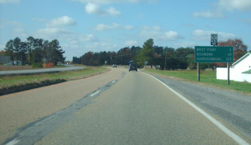
Posted: Fully posted; The last known cutout was on Main St in West Point and was removed about 2007.
When VA 33 was moved to the MLK Bridge routing, all the shields from the center of the bridge west to US 33-250 were US 33 shields. Some of the shields were replaced with correct VA 33 shields over time, but a field check in March 2013 found only US 33 shields again west of 25th St.
US 33 error shield exists on the I-64 EB ramp at VA 249.
Multiplexes: US 60, VA 156 (3.62 mi)
US 60 (2.76 mi)
VA 249 (0.22 mi)
I-64 (14.48 mi)
VA 30 (4.90 mi)
VA 14 (1.66 mi)
US 17 (2.36 mi)
US 17 Bus (0.80 mi)
VA 3 (3.45 mi)
Legislative names: Martha Washington Memorial Hwy, on its VA 249 duplex and also from VA 30-249 to West Point (since 10-23-58); Lewis B. Puller Memorial Hwy, from Saluda to West Point (since 3-21-72)
E. David Ringley Bridge over I-64, exit 205 (since 3-3-97); Farrar and Jeanette Howard Bridges over I-64, exit 220 (since 4-14-98); Lord Delaware Bridge over the Mattaponi River (since 3-26-38)
Other names: Hancock (EB)/Harrison (WB)/Leigh St/Mosby St/Fairmont Ave (Richmond); Nine Mile Rd (Henrico Co); Williamsburg Rd (US 60 dup); 14th St (West Point); George Washington Mem Hwy/Tidewater Trail (US 17 dup); Gloucester Rd (US 17 Bus dup)
Scenic Byway: No segments
Comment: It is unclear why VA 33 to at least US 17 didn't also become US 33.
Because of the poor posting practices in Richmond, the US 33-VA 33 transition has always felt murky.
VA 33 is misidentified as US 33 on the reverse of the 1951 Official in the West Point area.
VA 33 and US 360 cross without direct access.
I-64 blows off VA 33 in the Sandston area.
VA 33's dead end is not as ominous as VA 14's. It reaches the waterfront and ends at a private drive.
VA 33 still has mile markers in place approaching its respective West Point river crossings, both counting down to the bridges. I think this was put in place to give an idea how far you had to go in standstill traffic during the construction of the current bridges (both old bridges were draw bridges).
|
| Previous VA 33's:
1932 ROUTE LOG
NC STATE LINE: 0 - 0
VA 201: 3 - 3
US 58 WB, VA 12 WB: 7 - 10
US 58 EB, VA 12 EB: 1 - 11
VA 57: 0.5 - 11.5
VA 202: 0.5 - 12
VA 203: 7 - 19
VA 20 EB: 22 - 41
VA 20 WB: 1 block - 41
VA 219: 12 - 53
VA 22: 14 - 67
VA 206 SB: 3 - 70
US 221, VA 205: 0.5 - 70.5
VA 207 EB: 0.25 - 70.75
US 11 SB, US 311 END, VA 10 WB: 0.25 - 71
VA 10 EB, VA 206 NB, VA 207 WB: 1 - 72
VA 221: 2 - 74
VA 208: 2 - 76
VA 209: 4 - 80
VA 17: 3 - 83
VA 215 EB: 13.5 - 96.5
VA 215 WB: 0.5 - 97
US 60 EB, VA 801: 12 - 109
VA 806: 12 - 121
US 60 WB, VA 14: 2 - 123
VA 805: 2 - 125
VA 56: 15 - 140
VA 809 EB: 8 - 148
VA 809 WB: 1 - 149
VA 39 EB: 10 - 159
VA 810, VA 831: 0.5 - 159.5
VA 39 WB: 0.5 - 160
VA 812: 13 - 173
VA 838: 4 - 177
VA 17: 8 - 185
VA 817: 11 - 196
US 211, VA 21: 7 - 203
VA 819: 3 - 206
VA 820: 4 - 210
VA 824 WB: 11 - 221
VA 824 EB: 2 - 223
VA 55 WB: 10.5 - 233.5
VA 55 EB: 0.5 - 234
VA 54: 10 - 244
US 50, VA 36, VA 37 SB: 10 - 254
VA 37 NB, VA 822: 1 - 255
VA 833: 2 - 257
WV STATE LINE: 6 - 263
1937 ROUTE LOG
VA 35: 0 - 0
US 460: 17 - 17
Isle of Wight-Southampton Line: 4 - 21
GAP IN ROUTE
SR 626-678: 0 - 21
VA 158: 4 - 25
|
|
VA 33 #1: Appeared in 1923 as a renumbering of VA 3, running from North Carolina below Ridgeway to West Virginia above Winchester:
VA 33 initially began where today's US 220 enters Virginia from North Carolina then veered west using today's SR 686. VA 33 used today's US 220 Business through Ridgeway. VA 33 used today's SR 902 Mica Rd and SR 782 Old Sand Rd approaching Martinsville. VA 33 followed the general path of US 220 Business to the Smith River except it used Wilson Park Ln at the US 58 Bus Jct. VA 33 crossed the river just west of the current US 220 Bus SB bridge span.
VA 33's original Martinsville routing is uncertain, as the earliest inset I have is from 1927, where the route is shown to use Bridge St to Starling Ave northeast to Church St west, then one-way splits using Walnut (NB) and Bridge St (SB), then Main St and JOnes St before exiting via Fayette St and today's VA 457 and VA 57.
VA 33 followed VA 57 to modern US 220 and may have used today's SR 993 Reed Creek Rd. VA 33 appears to have followed more or less US 220 to the Rocky Mount area except it may have used SRs 755/619 loop. Approaching Rocky Mount, VA 33 used US 220 Business except SR 1020 and 1023 loops.
It is unclear if VA 33 used 220 Business through Rocky Mount or if it veered west through the downtown area...by 1932 the route was today's 220 Business. North of Rocky Mount, VA 33 followed SR 919 to Boones Mill. VA 33 followed US 220 (aside from a couple abandoned loop alignments) up to the Blue Ridge Pkwy, then used SR 766 Stable Rd and SR 789 Old Rocky Mt Rd.
Approaching Roanoke, VA 33 used US 220 Business into downtown, then followed Commonwealth Rd to Rutherford to 7th St to US 460 to 9th St north. It is unclear if VA 33 followed today's VA 115 to Lee Hwy or SR 601 further northeast.
VA 33 picked up today's US 11 northeast of Roanoke; It used US 11 to Buchanan except it used the SR 1001 loop near SR 654; SR 721 in Troutville; Snuffler Rd loop; SR 715 north of I-81 Exit 162; SR 1312 James River Terrace near Buchanan. In Buchanan, VA 33 followed US 11 to VA 43 south, then used Bridge St north across the James River, picking up SR 1305 on the other side. VA 33 cut east on VA 43 back to current US 11 north.
VA 33 followed US 11 north, then F-054 west of I-81. About where SR 608 crosses I-81, VA 33 began following F-055 (except an abandoned bridge north of SR 749) until it meets with US 11 at Exit 175. VA 33 used US 11, then SR 737 loop south of Natural Bridge. North of VA 130, VA 33 followed SR 743 Fanny Banger Rd across US 11 using Rices Hill Rd, then SR 686 Herring Hall Rd back to US 11 near Exit 180.
VA 33 followed US 11 through Fancy Hill, Reservation Loop near SR 739, and more US 11 (there are some visible abandoned alignments through here). VA 33 used SR 764 over to VA 251, then used VA 251 and Thornhill Rd to meet US 11 Business. VA 33 used Main St through Lexington, then crossed the Maury River via covered bridge just west of the current US 11 crossing. VA 33 used SR 631 west to SR 681 north to (cut off by I-64) SR 750 across VA 39 to SR 645. VA 33 used SR 645 northeast to US 11 near Exit 191.
VA 33 used US 11, then SR 785/716 Timber Ridge loop; several abandoned alignments along US 11 through Fairfield and Steeles Tavern to Greenville. VA 33 used SR 1205 Main St through Greenville and may have used SR 613 Old Greenville Rd to Staunton, though it definitely did not by 1924.
VA 33 used today's US 11 Business through Stauton, then followed US 11 to the West Virginia line except: Pickering Ln at Exit 257; Tollhouse Rd in Mauertown; In Winchester it is unclear whether VA 33 used Market or Braddock through downtown.
About 1926, VA 33 was removed from SR 686 below Ridgeway and SR 782 Sand Rd above Ridgeway.
In late 1926, US 311 was assigned to VA 33 south of Roanoke and US 11 was assigned to VA 33 north of Roanoke.
In 1926 or 1927, VA 33 was moved to use Avenham Ave, Broadway and McClanahan to Jefferson.
In 1927 or 1928, VA 33 was removed from 9th St/VA 115/SR 601 and placed on today's US 11 via Williamson Rd.
VA 33 Original Roanoke Routing
1925 Auto Trails
|
VA 33 rerouted in Roanoke
1928 Official
|
About 1928, VA 33 was removed from SR 993, if it indeed ever used it.
In 1928 or 1929, VA 33 was taken off Starling Ave in Martinsville and placed on Broad St north, then Church St east. Additionally, the one-way splits were removed, with VA 33 utilizing Walnut/Main/Franklin/Fayette.
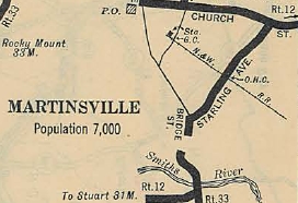
VA 33 using Starling
1927 Official
|
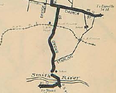
VA 33 using Broad
1929 Official
|
In July 1933, VA 33 was dropped from US 311 and US 11.
VA 33 #2: Appeared in July 1933 as a renumbering of VA 508, running from VA 35 Courtland northeast through Ivor to near Proctors Bridge. A second piece ran from VA 158 (now US 258 Bus) Smithfield west to the Septa area.
In 1938, both pieces of VA 33 were renumbered as VA 312. Today the main piece is SR 616 while the Smithfield piece is SR 626.
|
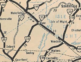
VA 33 #2
1933 Official
|
VA 33 ALT: Appeared in 1938 as a renumbering of VA 4 ALT. Ran on Mountain Rd, Courtney Rd, and Old Courtney Rd in Henrico County. The west end of this was at today's US 33 just NW of I-295.
VA 33 ALT was decommissioned by Act of the General Assembly in March 1942.
|
VA 33 ALT
1938-39 Official
|
|