< VA 37 | Home | VA 39 >
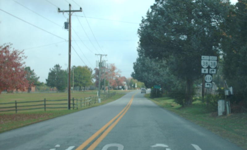
Photo: VA 38 unisigns from SR 614 northbound (photo by Mapmikey 11/10/07)
|
|
|
| ROUTE LOG |
US 360 Bus: 0 - 0 VA 153: 7.03 - 7.03
|
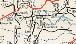
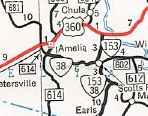
Creation: Appeared in July 1933 as a renumbering of VA 406. Originally, VA 38 ran from US 360 Amelia CH east to US 460 Sutherland This is the 2nd VA 38.
| Adjustments: In Oct 1940 (CTB), VA 38 was extended north from Amelia to end at VA 13 Tobaccoville, replacing some of VA 49. Sometime around the time VA 38 was extended north of Amelia CH, US 360 was removed from SR 656 and placed on current US 360 Business west out of Amelia CH. When this happened, VA 38's path (0.03 miles) between old and new 360 remained in the primary system, presumably as VA 38-Y.
In April 1951 (CTB), VA 38 east was truncated to US 360 Amelia. Amelia to below Wilsons Corner became an extended VA 153. From the old north end of VA 153 east to US 460, VA 38 was downgraded to SR 708. In Aug 1951 (CTB), VA 38 was re-extended east to Scotts Fork, replacing VA 153, plus the CTB explicitly said VA 38 was to be assigned with VA 153 south to the SR 708 intersection (about 3 miles). In Aug 1954 (CTB), VA 38 was downgraded to SR 681 between Tobaccoville and Amelia.
The 1958 Official is the last to show the useless VA 38-153 duplex and the 1958 Amelia County map does not show it. VA 38 was reconfigured at VA 153 to meet SR 602 in a 4-way intersection but this is not in the historic CTB minutes that I can find, so it may have occurred after 2001. Officially VA 38 was rerouted at the SR 614 intersection south of Amelia to its current 4-way intersection in the June 2009 CTB (originally, VA 38 and SR 614 did not touch). However, the intersection was already reconfigured the first time I visited there at least 3 years before this. VA 38 replaced SRs 1014 and 1018. Improvements: Paved upon inception from Amelia to Mannsboro and all of the Dinwiddie County portion. The rest of VA 38 was paved in 1934. VA 38 has no multilane segments. Posted: Fully posted; From US 360 Bus EB, VA 38 is posted to follow SR 1007. Multiplexes: None Legislative names: None Other names: Virginia Ave/Court St/Washington St/Church St (Amelia CH); Five Forks Rd (Amelia County) Scenic Byway: No segments Comment: VA 38 is a quiet route. VA 38 has always had the multiple turn tour of Amelia CH. | Previous VA 38's:
1932 ROUTE LOG US 15, US 29, VA 32: 0 - 0 VA 708: 11 - 11 US 1 NB, VA 31 NB: 20 - 31 VA 37: 1.5 - 32.5 US 1 SB, Begin US 17, VA 31 SB: 0.5 - 33 VA 50: 6 - 39 VA 633: 14 - 53 VA 621: 27 - 80 VA 13 EB: 1 block - 80 VA 13 WB: 3 - 83 VA 604: 9 - 92 VA 631: 9 - 101 US 17 SB, VA 30 WB: 9 - 110 VA 30 EB: 2 - 112 VA 603: 9 - 121 VA 601: 4 - 125 VA 629: 6 - 131 VA 600 WB: 1 - 132 VA 600 EB: 2 - 134 END VA 38: 11 - 145 |
VA 38 #1: Appeared in 1923 as a renumbering of VA 8 from Fredericksburg to Saluda.
In Jan 1925 (CTB), VA 38 was extended 3.7 miles south towards Mathews CH. In Oct 1926, VA 38 was extended along VA 31 through Fredericksburg to Falmouth, then replaced the two VA 327 pieces northwest to end at VA 32 (now US 15-29) Opal. VA 38 followed Pincess Anne St, then crossed the Rappahannock River just west of the current US 1 crossing, then used a bit of SR 607, then SR 1001. VA 38 used US 17 with the exception of the following loops: SR 700; SR 750 at Berea; SR 746; SR 704; SR 705 Hartwood; SR 706. In Fauquier County, VA 38 followed US 17 with the exception of these loops: SR 813 Goldvein; SR 718/634 Morrisville; SR 841; SR 839; SR 805/656 Bealeton; SR 837 Liberty. There was still a gap in the primary designation along this path.
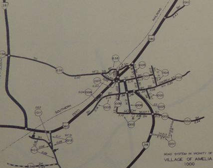
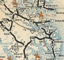
In July 1933, VA 38 was renumbered as VA 17 from Opal to Falmouth; US 1 remained from Falmouth to Fredericksburg; US 17 remained from Fredericksburg to Saluda; Saluda to Hartfield became VA 4; Hartfield to Cobbs Creek became VA 225; Cobbs Creek to Mathews became VA 198; Mathews to Bayside became VA 14. VA 38-Y: Appeared around 1940 as a renumbering of a bit of VA 38 which was moved onto the new path of US 360 (now US 360 Business) in Amelia CH. In June 1941 (CTB), VA 38-Y was downgraded to SR 1009. See scan above. |
|||||||||||||||||

Previous: VA 37 |
Next: VA 39
Top | Virginia Hwy Index
Home
Page last modified 8 March 2013