< VA 599 | Home | VA 700 to 799 >
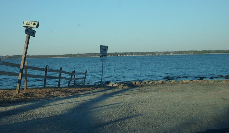
Photo: Old VA 604 ending at Bowler's Wharf, literally at the water's edge. (photo by Mapmikey 2/16/07)
| VA 600 not currently assigned | |||||
| Previous VA 600's: 1932 ROUTE LOG US 17, VA 29: 0 - 0 Mathews-Gloucester Line: 6.3 - 6.3 VA 38 WB: 7.5 - 13.8 VA 38 EB: 1.7 - 15.5 CR 108: 1.0 - 16.5 |
VA 600: Appeared in August 1928 as a renumbering of VA 291, running from US 17/VA 29 Gloucester to VA 38 (now VA 198) Mathews.
In Dec 1930 (CTB), VA 600 was extended along VA 38, then east 1 mile towards Diggs as an upgrade to CR 108. In July 1933, VA 600 was renumbered as VA 14 and VA 198. Today it remains these routes except VA 600 used SR 691 near Wan and SR 623/690 near Nuttall..
|
||||
| VA 600-Y not currently assigned | |||||
| Previous VA 600-Y's: 1932 ROUTE LOG US 17, VA 29: 0 - 0 VA 600: 0.04 - 0.04 |
VA 600Y: The 1932 Gloucester County map strongly suggests a triangle made up of primary routes at the US 17-VA 600 jct in Gloucester.
In July 1933, VA 600Y was renumbered as VA 14Y. Today the triangle setup is gone, replaced by the 4-lane VA 3-14. |
 |
|||
| VA 601 not currently assigned | |||||
| Previous VA 601's: 1932 ROUTE LOG VA 38: 0 - 0 Gloucester-Mathews Line: 1.94 - 1.94 CR 112: 3.01 - 4.95 |
VA 601: Appeared in August 1928 as upgraded routing in two pieces. Ran from VA 38 (now VA 3) near Cobbs Creek west 1.4 miles to the current VA 3-198 split. Also, it ran from the Mathews-Gloucester Line west 3.01 miles.
In June 1930 (CTB), VA 601 piece 1 was extended to the Gloucester line, connecting the two pieces. In July 1933, VA 601 was renumbered to VA 198. Note that the Aug 1928 CTB actually says piece 1 began at VA 291 (current VA 14) near the Mathews line running 3.01 miles towards Glenns along current SR 602. However, the Aug '28 map shows it the way I described above. I did not find any CTB references in 1928 to show this was changed. |
 |
|||
| VA 602 not currently assigned | |||||
| Previous VA 602's: 1932 ROUTE LOG US 17 SB, VA 29: 0 - 0 US 17 NB, VA 30: 5.3 - 5.3 |
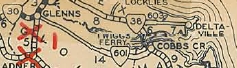
VA 602: Appeared in August 1928 as new routing running from US 17-VA 29 Adner to US 17-VA 30 Glenns.
Shortly after, US 17 was assigned to this route, rendering VA 602 to the secret-route bin. In July 1933, VA 602 was dropped from US 17. |
 |
|||
| VA 603 not currently assigned | |||||
| Previous VA 603's: 1932 ROUTE LOG VA 38: 0 - 0 CR 210: 5.8 - 5.8 |
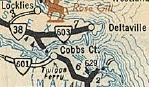
VA 603: Appeared in August 1928 as new primary routing running from VA 38 (now VA 3-33 split) Hartfield east 2 miles.
In Dec 1930 (CTB), VA 603 was extended east 3.8 more miles to Deltaville (but not Stingray Pt) as an upgrade to CR 3. In July 1932, VA 603 was renumbered as part of VA 4. Today it is part of VA 33. |
 |
|||
| VA 604 not currently assigned | |||||
| Previous VA 604's: 1932 ROUTE LOG VA 13: 0 - 0 US 17, VA 38: 11.11 - 11.11 END VA 604: 2.31 - 13.42 |
VA 604: Appeared in August 1928 as an upgrade to CR 13, running from VA 13 (now US 360) Millers Tavern east 9.61 miles.
In June 1930 (CTB), VA 604 was extended east to US 17-VA 38 Center Cross. In Dec 1930 (CTB), VA 604 was extended east to Bowlers Wharf. In late 1931, VA 604 was rebuilt between VA 13 and US 17. This left behind CRs 2/210 (now SR 604/649), 211 (now SR 605), 212, 213, 214/5 (now SR 648/612) and 216. In July 1933, VA 604 became VA 199. Today, it is SR 684.
|
||||

| VA 605 not currently assigned | |||||
| Previous VA 605's: 1932 ROUTE LOG VA 37: 0 - 0 VA 37 EB: 5 - 5 VA 37 WB: 0.09 - 5 VA 607: 14.5 - 19.5 |
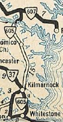
VA 605: Appeared in August 1928 as upgraded routing. It began in two pieces: from 2 miles south of Kilmarnock to 2.7 miles north of Kilmarnock at the Northumberland Line; from VA 607 (now US 360) Burgess south 8 miles.
In Aug 1929 (CTB), VA 605 piece 1 was extended south 1.5 miles. In June 1930 (CTB), VA 605 piece 1 was extended south to VA 37 (now VA 200) White Stone. In Dec 1930 (CTB), VA 605 piece 2 was extended south 3.8 miles to connect to piece 1. In July 1933, VA 605 became VA 200. Kilmarnock to White Stone is now VA 3. VA 605 used Northumberland SR 699; Tipers Ferry (just to the west of current Wicomico River bridge); private subdivison street; SR 678; SR 609; SR 679 loops (some are still unpaved). |
 |
|||
| VA 606 not currently assigned | |||||
| Previous VA 606's: 1932 ROUTE LOG CR 3: 0 - 0 VA 37: 2.10 - 7.34 |
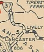
VA 606: Appeared in August 1928 as upgraded routing. It ran from VA 37 (curr VA 3) Lively southwest to CR 3 (now VA 354).
In July 1932 (CTB), VA 606 was extended along CR 3 south 0.20 miles to current SR 681. In July 1933, VA 606 became VA 201. The CR 3 extension is now part of VA 354. |
 |
|||
| VA 607 not currently assigned | |||||
| Previous VA 607's: 1932 ROUTE LOG VA 37: 0 - 0 VA 607Y: 0.5 - 0.5 VA 608 WB: 11.5 - 12 VA 608 EB: 0.6 - 12.6 VA 13: 4.7 - 17.3 VA 628: 7 - 24.3 VA 605: 8 - 32.3 END VA 607: 7 - 39.3 |
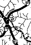
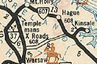
VA 607: Appeared in August 1928 as a renumbering of VA 371, running from VA 37 (now VA 202-SR 600 jct) Templemans east across the Nomini Ferry then through Callao and ending at the cul-d-sac in Reedville.
In late 1930, VA 607 was rebuilt in the Hyacinth area, leaving behind CR 6 (now SR 617). In Dec 1930, VA 607 was extended west to the new location of VA 37, replacing a piece of VA 37 along current SR 766). In July 1933, VA 607 became VA 202 from Templemans to Callao and US 360 from Callao to Reedville. Today east of Callao VA 607 used SR loops: SR 694 Avalon, SR 640/695 Blundon Corner, SR 646/702 Lilian, SR 652/703 Beverlyville and SR 655 Reedville. Also, it used SR 644 to the Reedville Cul-D-Sac. |
 |
|||
| VA 607-Y not currently assigned | |||||
| Previous VA 607-Y's: 1932 ROUTE LOG VA 37: 0 - 0 VA 607: 0.25 - 0.25 |
VA 607Y: In Dec 1930, it appears VA 37 was rerouted to the current alignment of VA 3 through the Templemans area. Today's SR 766 and 767, which was how VA 37 went, became VA 607 and VA 607-Y.
In July 1933, VA 607Y was renumbered as VA 202Y. Today it is SR 767. |
 |
|||
| VA 608 not currently assigned | |||||
| Previous VA 608's: 1930 ROUTE LOG VA 37: 0 - 0 VA 37: 9.23 - 9.23
1932 ROUTE LOG |
VA 608 #1: Appeared in August 1928 as upgraded routing, running from VA 37 (now SR 690) near Templemans southeast 4.39 miles. See scan under VA 607 entry.
In Aug 1929 (CTB), VA 608 was extended 4.84 more miles to end at VA 37 (now SR 690) Warsaw. In Dec 1930 (CTB), VA 608 was renumbered as VA 37-E. Today it is part of VA 3. VA 608 #2: Appeared as new primary routing in Dec 1930 (CTB), running from VA 37-E (now VA 3) east 2.29 miles. In June 1931 (CTB) a second piece of VA 608 appeared, running from VA 607 (now VA 202) east to Kinsale. In July 1932 (CTB), VA 608 piece 1 was extended east to VA 607 as an upgrade to CRs 9 and 112 connecting to piece 2 of VA 608. In July 1933, VA 608 was renumbered as VA 203. It remains so today except it used SRs 670/604 at Griffiths Corner. |
 |
|||
| VA 609 not currently assigned | |||||
| Previous VA 609's: 1932 ROUTE LOG VA 13: 0 - 0 CR 1: 10.94 - 10.94 |
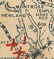
VA 609: Appeared in August 1928 as upgrade to CR 1. Ran from VA 13 near Warsaw north 8 miles towards Newland.
In Dec 1930 (CTB), VA 609 was extended north 1 mile. In June 1931 (CTB), VA 609 was extended north another 1.54 miles to the Oak Row area. In July 1932 (CTB), VA 609 was extended north another 0.40 miles. In July 1933, VA 609 became part of VA 204. Today this is SR 624. |
 |
|||
| VA 610 not currently assigned | |||||
| Previous VA 610's: 1932 ROUTE LOG VA 37: 0 - 0 END VA 610: 1.7 - 1.7 |
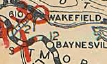
VA 610: Appeared in August 1928 as a renumbering of VA 372, running from VA 37 (now VA 3) to Wakefield, George Washington's boyhood home.
In July 1933, VA 610 became part of VA 204. |
 |
|||
| VA 611 not currently assigned | |||||
| Previous VA 611's: 1932 ROUTE LOG VA 37: 0 - 0 VA 37: 20 - 20 |
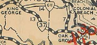
VA 611: Appeared in August 1928 as a renumbering of VA 377 from VA 37 (now VA 3) Oak Grove to near Colonial Beach, then extended west 5 miles. Also, a second piece began at VA 37 (now VA 3) Purkins Corner running east 8 miles to the Westmoreland-King George Line.
In Dec 1930 (CTB), VA 611 piece 1 was extended west 2.9 miles to connect to piece 2. In July 1933, VA 611 became VA 205. Today it is still mostly VA 206 except VA 611 used SR 705 and SR 706 loops in King George County. |
 |
|||
| VA 612 not currently assigned | |||||
| Previous VA 612's: 1932 ROUTE LOG VA 37: 0 - 0 END VA 612: 13 - 13 |
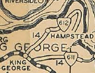
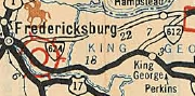
VA 612: Appeared in August 1928 as a renumbering of VA 375, running from VA 37 (now VA 3) King George CH to Dahlgren.
In 1931, VA 612 was rerouted at Owens to head directly east to Dahlgren. The original routing (became CR 10 and CR 109) went via Hooes to loop around to Dahlgren via SRs 624 and 614. In July 1933, VA 612 became VA 206. Some of VA 611 is inside the secured area of Dahlgren's Naval facility and it also used SR 632 in the Hampstead area.
|
||||

| VA 613 not currently assigned | |||||
| Previous VA 613's: 1932 ROUTE LOG US 1, VA 54: 0 - 0 VA 50: 12.95 - 12.95 |
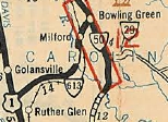
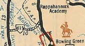
VA 613: Appeared in August 1928 as new primary routing, running from US 1/VA 31 Carmel Church northeast to Milford.
In Dec 1930 (CTB), VA 613 was extended to VA 50 (now US 301 Bus/VA 2) Bowling Green. In July 1933, VA 613 became part of VA 207. VA 207 has been realigned in many locations. VA 613 used SR 652/716; SR 639/713; SR 714; SR 601/715; SR 722 through Milford; SR 614 into central Bowling Green. |
 |
|||
| VA 614 not currently assigned | |||||
| Previous VA 614's: 1932 ROUTE LOG US 1, VA 31: 0 - 0 VA 51: 4.7 - 4.7 |
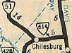
VA 614: Appeared in August 1928 as upgraded routing, running from US 1/VA 31 Ladysmith west 2.92 miles.
In Dec 1930 (CTB), VA 614 was extended west to VA 51 (now SR 738) Chilesburg. In July 1933, VA 614 became part of VA 207. Today it is SR 639. |
 |
|||
| VA 615 not currently assigned | |||||
| Previous VA 615's: 1932 ROUTE LOG US 1, VA 31: 0 - 0 VA 50: 11.5 - 11.5 |
VA 615: Appeared in August 1928 as upgraded routing running from US 1/VA 31 Welch east to Woodford.
In Dec 1930 (CTB), VA 615 was extended east to VA 50 (now VA 2). July 1933, VA 615 was renumbered as VA 208. Today it is SR 605 and SR 625. |
 |
|||
| VA 616 not currently assigned | |||||
| Previous VA 616's: 1932 ROUTE LOG VA 51: 0 - 0 CR 7: 18.8 - 18.8 |
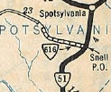
VA 616: Appeared in August 1928 as upgraded routing, running from VA 51 (now VA 208-SR 738 jct) Snell west 5.75 miles to the Post Oak area.
In Dec 1930 (CTB), VA 616 was extended west 4.19 miles. In July 1932 (CTB), VA 616 was extended west 7 more miles as an upgraded to CR 7 to Paytes then curled southwest to end at Granite Springs. In July 1933, VA 616 became VA 209. Today it is VA 208 from Snell to Post Oak, SR 608 out to Paytes, and SR 601 down to Granite Springs. |
 |
|||
| VA 617 not currently assigned | |||||
| Previous VA 617's: 1932 ROUTE LOG VA 37: 0 - 0 VA 51: 12.4 - 12.4 |
VA 617: Appeared in August 1928 as upgraded routing from VA 37 (now VA 3) near Wilderness southeast 10 miles.
In Dec 1930 (CTB), VA 617 was extended east to VA 51 (current VA 208) Spotsylvania CH. In July 1933, VA 617 became VA 210. Today it is SR 613. |
 |
|||
| VA 618 not currently assigned | |||||
| Previous VA 618's: 1932 ROUTE LOG US 1, VA 31: 0 - 0 CR 118-119: 3.50 - 3.50 |
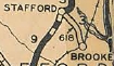
VA 618: Appeared in August 1928 as upgraded routing, running from US 1/VA 31 Stafford CH east to Brooke Station.
In July 1933, VA 618 became VA 212. Today it is SR 630 and SR 629. |
 |
|||
| VA 619 not currently assigned | |||||
| Previous VA 619's: 1932 ROUTE LOG US 1, VA 31: 0 - 0 CR 12: 11.25 - 11.25 |
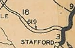
VA 619: Appeared in August 1928 as new routing, running from US 1/VA 31 Aquia west 6.7 miles.
In Dec 1930 (CTB), VA 619 was extended west 1 mile to Ruby. In July 1932 (CTB), VA 619 was extended east to the historic Aquia Church and west to just short of the Fauquier County line. In July 1933, VA 619 became VA 213. Today it is SR 610. |
 |
|||
| VA 620 not currently assigned | |||||
| Previous VA 620's: 1932 ROUTE LOG VA 31: 0 - 0 CR 8: 2.5 - 2.5 |
VA 620: Appeared in June 1930 (CTB), running from VA 37 (now VA 3) Lerty east to Stratford Hall, birthplace of Robert E. Lee,
In July 1933, VA 620 became VA 214. |
 |
|||
| VA 621 not currently assigned | |||||
| Previous VA 621's: 1932 ROUTE LOG US 17, VA 38: 0 - 0 CR 8: 7.6 - 7.6 |
VA 621: Appeared in December 1930 as a partial renumbering of US 17/VA 38 and an upgrade to CR 8, running from US 17/VA 38 Tappahannock west 2.5 miles to Scott Mill.
In July 1932 (CTB), VA 621 was extended to Rexburg as an upgrade to CR 8. In July 1933, VA 621 became VA 215. Today it is mostly SR 627 but the airfield at Tappahannock blocks the original path of VA 621, which ended at the US 17-SR 657 jct, 1 block north of US 360. |
 |
|||
| VA 622 not currently assigned | |||||
| Previous VA 622's: 1932 ROUTE LOG US 17, VA 29: 0 - 0 CR 3: 4 - 4 |
VA 622: Appeared in December 1930 as upgraded routing, running from US 17/VA 29 (now SR 1216) Hayes east to Achilles.
In July 1933, VA 622 became VA 216. Today it is also SR 1219. |
 |
|||
| VA 623 not currently assigned | |||||
| Previous VA 623's: 1932 ROUTE LOG US 17, VA 29: 0 - 0 CR 116: 4.3 - 4.3 |
VA 623: Appeared in December 1930 as new primary routing, running from US 17/VA 29 Ark south only 0.15 miles.
In July 1932, VA 623 was extended south 4.15 miles towards Almonds Wharf. In July 1933, VA 623 became VA 217. Today it is SR 606. |
 |
|||
| VA 624 not currently assigned | |||||
| Previous VA 624's: 1932 ROUTE LOG VA 37: 0 - 0 VA 612: 21.5 - 21.5 |
VA 624: Appeared in Dec 1930 (CTB) as upgraded routing in two pieces: VA 37 (now VA 3 Bus) White Oak east 4 miles; VA 612 (now VA 206) Hampstead west 2 miles.
In June 1931 (CTB), piece 2 was extended west 3 miles to Osso. In July 1932 (CTB), VA 624 piece 1 was extended to the King George Line as an upgrade to CR 9 and piece 2 was extended west to 3 miles short of Stafford County as an upgrade to CR 9. In July 1933, VA 624 was renumbered as VA 218. Today it also is Stafford SR 1107; King George SR 651 and most of VA 212. |
 |
|||
| VA 625 not currently assigned | |||||
| Previous VA 625's: 1932 ROUTE LOG VA 30: 0 - 0 END VA 625: 1.20 - 1.20 |
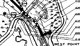
VA 625: Appeared in Dec 1930 as new routing, running from VA 30 near West Point 1 mile to the Port Richmond Airport.
In July 1932 (CTB), VA 625 was extended 0.20 miles. In July 1933, VA 625 became VA 219. Today it is SR 701. |
 |
|||
| VA 626 not currently assigned | |||||
| Previous VA 626's: 1932 ROUTE LOG VA 30: 0 - 0 CR 1-2-201: 0.40 - 0.40 |
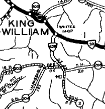
VA 626: Appeared in Dec 1930 as new routing, running from VA 30 near King William CH south 0.98 miles.
IN July 1932 (CTB), VA 626 was extended south 4.7 more miles to about Lanesville as an upgrade to CR 2. In July 1933, VA 626 became VA 220. Today it is SR 633. |
 |
|||
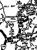
| VA 627 not currently assigned | |||||
| Previous VA 627's: 1932 ROUTE LOG VA 37: 0 - 0 END VA 627: 3.8 - 3.8 |
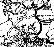
VA 627: Appeared in Dec 1930 as new routing, running from VA 37 (curr SR 646) Christ Church southwest 3.8 miles to Weems.
In July 1933, VA 627 became VA 222, which has been rebuilt. VA 627 used today's SR 709 and also the SR 666 loop near Weems. |
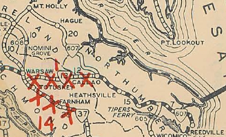
1932 Lancaster County |
|||
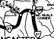
| VA 628 not currently assigned | |||||
| Previous VA 628's: 1932 ROUTE LOG VA 37: 0 - 0 VA 607: 10 - 10 |
VA 628: Appeared in Dec 1930 as new routing in two pieces: VA 37 (current SR 601) McNeals Corner north 0.20 miles; VA 607 (now US 360) Heathsville south 0.20 miles.
In July 1932, VA 628 was added to connect the two small pieces. In July 1933, VA 628 became VA 201. |
 |
|||
| VA 628Y not currently assigned | |||||
| Previous VA 628Y's: 1932 ROUTE LOG VA 37: 0 - 0 VA 628: 0.12 - 0.12 |
VA 628Y: Appeared in Dec 1930 as new routing connecting VA 37 (now VA 201) to VA 628 (also now VA 201) McNeals Corner.
In July 1933, VA 628Y became VA 201Y. Today it is part of VA 201. |
 |
|||
| VA 629 not currently assigned | |||||
| Previous VA 629's: 1932 ROUTE LOG VA 38: 0 - 0 END VA 628: 2.00 - 2.00 |
VA 629: Appeared in Dec 1930 as new routing, running from VA 38 (now VA 198) Hudgins to the ferry landing to Gwynn Island (well east of current bridge).
In July 1933, VA 629 became VA 223. Today it is also the Redart Loop plus SR 669 to the ferry landing.. |
 |
|||
| VA 630 not currently assigned | |||||
| Previous VA 630's: 1932 ROUTE LOG VA 600: 0 - 0 CR 104: 5 - 5 |
VA 630: Appeared in Dec 1930 as new routing running from VA 600 (now VA 14) Foster south 1 mile.
In July 1932, VA 630 was extended south 4 more miles towards Mobjack. In July 1933, VA 630 became VA 224. Today it is SR 660. |
 |
|||
| VA 631 not currently assigned | |||||
| Previous VA 631's: 1932 ROUTE LOG US 17, VA 38: 0 - 0 CR 106: 4.2 - 4.2 |
VA 631: Appeared in Dec 1930 as new routing running from US 17/VA 38 near Churchview north 0.20 miles.
In July 1932, VA 631 was extended north 4 miles towards Water View. In July 1933, VA 631 became VA 226. Today it is SR 640. |
 |
|||
| VA 632 not currently assigned | |||||
| Previous VA 632's: 1932 ROUTE LOG VA 37: 0 - 0 VA 607: 6.1 - 6.1 |
VA 632: Appeared in Dec 1930 as new routing running from VA 37 (now VA 3) near Emmerton south 2.5 miles to about Tidewater.
In July 1932, VA 632 was extended south to Sharps as an upgrade to CR 10. In July 1933, VA 632 became VA 228. Today it is SR 642. |
 |
|||
| VA 633 not currently assigned | |||
| Previous VA 633's: 1932 ROUTE LOG US 17, VA 38: 0 - 0 END VA 633: 1.0 - 1.0 |
VA 633: Appeared in July 1932 as an upgrade to CR 1, running from US 17/VA 38 to Port Royal.
In July 1933, VA 633 became VA 229. VA 633 does not appear on any VDOT maps I can find. VA 633 is the highest 6xx route in the 1928-33 system. | ||
| I-664 |
Previous: VA 599 |
Next: VA 700 - VA 799
Top | Virginia Hwy Index
Home
Page last modified 17 March 2011