|
From:  Ft. Myer (Arlington County) Ft. Myer (Arlington County)
To: Washington DC line near the Pentagon(Arlington County)
Total Length: 2.54 miles
|
|
|
|
|
ROUTE LOG
US 50: 0 - 0
VA 244: 0.82 - 0.82
I-395 (exit 8): 0.35 - 1.17
VA 110: 0.85 - 2.02
WASH DC LINE: 0.52 - 2.54
|
|
Creation: Created Dec 1964 (CTB) in its present form. This portion of Washington Blvd. had been part of the Pentagon Road Network created 20 years earlier. Public sections of the Pentagon Road Network were transferred to the CTB for maintenance in Sept 1961 and all commitments required for that were completed by Dec. 1964. This is the 3rd VA 27.
Adjustments: None
Improvements: Multilane freeway since inception.
Posted: Fully posted; Error US 27 shield may still exist exiting a Pentagon parking lot (first reported to me by Russel Blau)
For a number of years (gone now), there was a VA 27 shield with the letters "va." above the number on the SB George Washington Pkwy (which is in Washington DC at this location).
Multiplexes: None
Legislative names: None
Other names: Washington Blvd.
Scenic Byway: No segments
Comment: VA 27 has a brief reversible roadway just south of VA 110 that ties into the I-395 reversible HOV lanes.
|
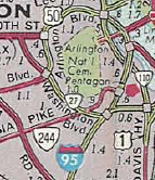
Current VA 27
1966 Official
|
|
| Previous VA 27's:
1940 ROUTE LOG
US 17: 0 - 0
VA 172: 4 - 4
VA 167 NB, VA 168 SB: 6 - 10
VA 167 SB, VA 168 NB: 0.5 - 10.5
US 60 WB: 0.5 - 11
VA 169: 2 - 13
OLD POINT COMFORT FY: 2 - 15
OCEAN VIEW FY: 0 - 15
US 60 EB: 3 - 18
VA 337: 6 - 24
US 58 WB, US 460 WB: 1 - 25
US 58 EB, US 460 EB, VA 13 NB: 1 - 26
US 460 EB: 2.5 - 28.5
US 460 WB: 0.5 - 29
VA 13 WB: 2.5 - 31.5
VA 166 WB: 0.5 - 32
VA 166 EB: 4 - 36
VA 165: 1 - 37
VA 193: 11 - 48
NC STATE LINE: 1 - 49
1953 ROUTE LOG
VA 6: 0 - 0
US 250: 16 - 16
US 33, VA 22: 9 - 25
| |
|
VA 27 #1: Began in January 1918 as an original state route defined by the general assembly:
Route 27: Norfolk, Berkley, Great Bridge, Hickory, North Carolina Line
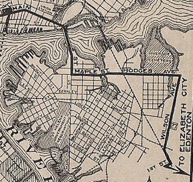
VA 27 began at VA 10-12 at the intersection of Main St and Bank St, heading east on Main then south across the East Elizabeth River about where the Harbor Park Stadium is into Berkley/South Norfolk and today's S. Main St. VA 27 turned east on Maple St which turned into Hodges Ave (both of these are now part of Indian River Rd), then south on Wilson Ave (above 22nd St is US 460 now) to Liberty St (VA 246) east to Campostella Rd south out of town.
VA 27 followed Campostella to today's VA 190 east to Great Bridge, then today's VA 168 Business then a bit of mainline VA 168, Old Battlefield Blvd (no longer connects back to), then VA 168 to the North Carolina line.
In Oct 1922 (CTB), VA 27 was approved to be rerouted from Great Bridge to Hickory via Fentress: today's VA 165 east to Fentress Rd east to Centreville Tpk south back to VA 168 Business. This alignment is shown on the 1922 Auto Trails Map.
The routing of VA 27 south of Great Bridge apparently was in dispute after that. The March 1923 CTB minutes has a discussion suggesting that the route had originally been routed via Fentress from the beginning so why is it heading south via today's 168 Business. The 1923 Official map shows VA 27 heading due south from Great Bridge.
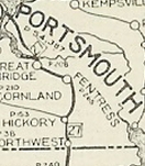
VA 27 through Fentress?
1922 Auto Trails
|
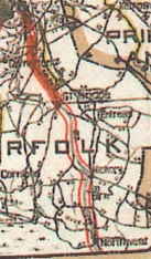
VA 27 avoiding Fentress
1923 Official
|
By 1925, VA 27 was rerouted in South Norfolk to stay on Main St further south to Liberty St southeast to Poindexter St southwest to Banbridge St (now VA 166). VA 27 then used today's VA 190 to Great Bridge.
VA 27 initial South Norfolk routing
1922 Auto Trails
|
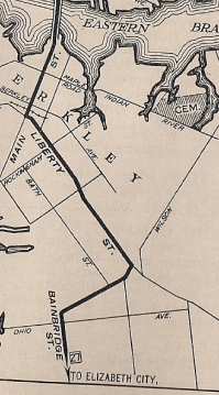
VA 27 moved to Liberty St.
1925 Auto Trails
|
In Aug 1932 (CTB), VA 27 was extended north as new primary routing using Church St and Granby St to end at US 60/VA 500 Ocean View.
In July 1933, VA 27 was extended north by following US 60 across the ferry to Old Point Comfort and into central Hampton, then replacing VA 514 from Hampton out to US 17 Tabb. The route used (north to south): US 17 Tabb southeast to Drummonds Corner near Poquoson on today's VA 134, then south via VA 172 Magruder Ave and Armistead Ave to Hampton, then duplexed with US 60 on Queen St and Tyler St across the Hampton River, then used today's VA 143 which VA 27 followed to Phoebus, but continued on County St and Water St down to Mill Creek. VA 27 then used VA 143's approach to Fort Monroe, then used Ingalls Rd through Fort MOnroe down to the ferry landing at Old Point Comfort. On the Norfolk side, VA 170 used Ocean View Ave to Granby St
In 1934, VA 27 was rerouted off of the Main St bridge over East Elizabeth River and instead followed Princess Anne (then-US 58) east, Park Ave south and Brambleton southeast across the river to Wilson Rd southwest to Bainbridge.
In 1936, VA 27 was restored to its Main St crossing of the river into South Norfolk along with Liberty St.
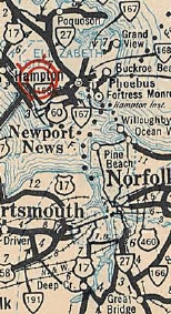
VA 27 extended through Hampton to US 17
1933 Official
|
VA 27 moved to Campostella Bridge
1935 Official
|
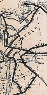
VA 27 returned to Main St bridge
1936 Official
|
In April 1937 (CTB), VA 27 was moved onto the 22nd St crossing of the RR in South Norfolk leaving beind part of Wilson Rd.
In Oct 1940 (CTB), VA 27 was renumbered as VA 170.
VA 27 #2: Created Oct 1940 (CTB) as a renumbering of the three pieces of original VA 16:
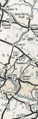
1. US 60 west of Powhatan CH through Columbia to Kents Store
2. US 250 Ferncliff through Louisa to the Orange County Line
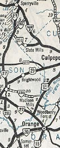
3. US 15/VA 20 Orange through Madison CH to VA 522 Sperryville (the 1946 Orange County map shows VA 27 duplexing with US 15 south of Madison Mills)
In Jan 1941 (CTB), VA 27 was removed from SR 687 south of Madison CH and instead sent with existing VA 230 and US 29 from Oneal to Madison CH.
In April 1944 (CTB), the northern piece of VA 27 was renumbered as VA 231 from Oneal to Sperryville and VA 230 from Oneal to Madison Mills. Also, the middle piece of VA 27 north was truncated to US 33/VA 22 Louisa, leaving behind SR 669.
In May 1945 (CTB), the two remaining segments of VA 27 were connected when SR 614 from Kents Store to US 250 Ferncliff were put into the primary system.
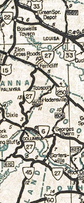
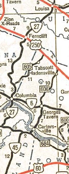
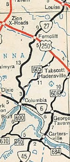
In May 1950 (CTB), VA 27 south was truncated to VA 45 Cartersville leaving behind SR 684.
In April 1951 (CTB), VA 27 south was truncated to VA 6 Columbia leaving behind SR 690.
In May 1953 (CTB), the remainder of VA 27 from Columbia to Louisa CH was downgraded to SR 659 (now VA 208 plus SR 630 into central Louisa CH).
In Dec 1953 (CTB) a sizable delegation lobbied to have Ferncliff to Louisa returned to the primary system and even suggested it could be part of the recently created VA 208. The CTB denied this request and it took 19 more years to accomplish the mission.
SR 659 in Fluvanna County had one of the last white border SR shields remaining up until the early 2000s.
|
VA 27 #2 northern segment
1941-42 Official
|
VA 27 #2 central/southern pieces
1941-42 Official
|
VA 27 shortened but connected
1946 Official
|
VA 27 truncated to VA 45
1951 Official
|
VA 27's last version
1952 Official
|
VA 27 ALT?: Discovered by NE2 on the 1940 Rand McN inset of Norfolk. It appears to use Church St from near the Old Main St bridge to South Norfok north to Granby St.
There is no mention of this in the CTB so it is unclear if this is real or not.
|
VA 27 ALT?
1940 Rand McN
|
|
Previous: VA 26 |
Next: VA 28
Top | Virginia Hwy Index
Home
Page last modified
26 February 2015
|