< VA 320 | Home | VA 322 >
| US 321 | |||||||
| |||||||
|
Creation: It appears VA 321 was created around 1938. There is no specific reference in the CTB that I can find and William and Mary College did NOT receive mileage in July 1932 as other schools had.
It is explicitly shown in
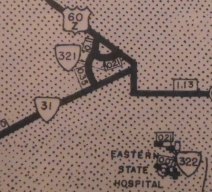
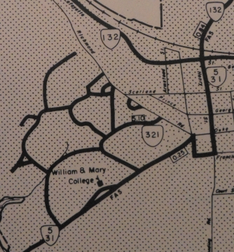
the 1943 VDOT County Atlas as a 0.46-mile street which appears to be Stadium Dr and the northeastern third of Landrum Dr today connecting VA 31 (now VA 5) and US 60Z (now Richmond Rd) plus a second street (0.21 mi) which appears to be James Blair Dr from US 60Z to the first VA 321 segment. This is the 3rd VA 321.
Adjustments: In Oct 1947, three segments of unidentified road totaling 0.167 miles were deleted from the system, while 0.649 miles of new roads including the veterans housing area were added to VA 321. In April 1951 (CTB), four unidentified streets totaling 0.509 miles were added to VA 321. In April 1955 (CTB), 0.570 more miles of unidentified driveways were added to VA 321. In March 1958 (CTB), 0.205 miles of driveways described as north and south of the new Phi Beta Kappa Memorial Hall were added to VA 321. and In Oct 1967 (CTB), VA 321 received 1.14 more miles of unidentified streets. In March 1972 (CTB), 3 segments were added to VA 321: Campus Dr (I think this is Ukrop Way now) from the triangle below William and Mary Hall northeast to the Dillard St/Blair Ave jct. (0.19 mi); new construction extending Monticello Ave 0.80 miles to Ironbound Rd; Compton Dr from Monticello Av to William and Mary Hall parking lot (0.48 mi)
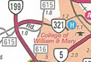
In March 1977 (CTB), 0.08 miles of "Campus Dr between Campus Rd and Botetourt Dr" was removed from VA 321. Around 2000, VA 321 was extended to the new VA 199 freeway and over to SR 613. The 2000-01 official map shows part of this extension as VA 5 ALT, which apparently did not pan out.
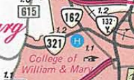
Posting: Some posting outside campus, including the western end and reassurance markers at VA 199; also a reassurance marker east of SR 615 Ironbound Road (which according to Dave Montuori was still a cutout in the early 1980s) Comment: Includes most roads in the college. Despite several changes, the 1958 James City County map shows the same as the 1946 one. In January 2003 I got some info about VA 321's west end (thanks to Dan Ehlke):
|
|||||||
| Previous VA 321's: 1926 ROUTE LOG BEGIN VA 321: 0 - 0 US 15, VA 32: 2 - 2 END VA 321: 51 - 53 1933 ROUTE LOG US 501, VA 18: 0 - 0 US 501, VA 18: 4 - 4 |
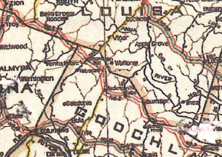
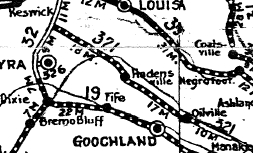
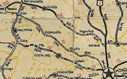
VA 321 #1: Created in 1923 as a renumbering of VA 2 CONN, which was created by legislative action. Ran from VA 32 (probably the intersection of SR 615-631) Zion to Oilville.
In March 1924 (CTB), VA 321 was extended east 4 miles towards Richmond as new routing. In January 1925 (CTB), VA 321 was extended east another 6 miles towards Richmond as new routing. In May 1926 (CTB), VA 321 was extended 2 miles west toward Keswick from VA 32 and east 7.5 more miles towards Richmond. In October 1926 (CTB), VA 321 was renumbered as an extended VA 41. Today it is SR 615; US 250; SR 607 loop: SR 626 loop; SR 659 to SR 653/601 loop; Three Chopt-Shannon Hill Rd; SR 699 loops; SR 606 to Hadensville; SR 609 to East Leake; SR 700 loop; SR 634 loops; SR 702/636 loop; SR 612/621 to Centerville.A lot of these loops are named "Three Chopt Roads" between Zion and Richmond which would be VA 321's routing. VA 321 is erroneously still labeled as part of VA 2 on the 1923 Official.
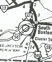
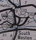
VA 321 #2: Appeared in December 1930 (CTB) as a newly numbered route. Was a loop from US 501/VA 18 South Boston to US 501/VA 18 near Halifax. In July 1933, this became US 501 (which had been using current VA 129).
|
||||||
Previous: VA 320 |
Next: VA 322
Top | Virginia Hwy Index
Home
Page last modified 24 May 2020