|
From:  Paint Bank (Craig County) Paint Bank (Craig County)
To:   City of Covington City of Covington
Total Length: 25.86 miles
|
|
|
|
|
ROUTE LOG
VA 311: 0 - 0
Alleghany-Craig Line: 5.12 - 5.12
Covington-Alleghany Line: 18.42 - 23.54
US 60, US 220: 2.32 - 25.86
|
|
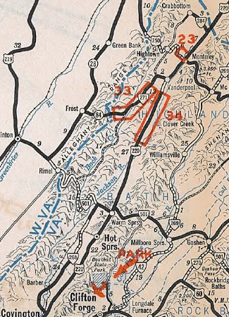
Creation: Appeared July 1933 as a renumbering of VA 800 from the WV Line north of Monterey south past Covington to the Craig-Alleghany Line. This is the 2nd VA 18.
Adjustments: In Sept 1934 (CTB), VA 18 was extended over what I presume was SR 600 to VA 311 Paint Bank.
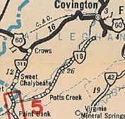
VA 18 ending at Craig County Line
1933 Official
|
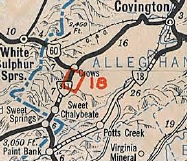
VA 18 extended to VA 311
1936 Official
|
In 1935, VA 18 north was truncated to its current endpoint in Covington. Covington to West Virginia via Monterey became US 220. Note that VA 18 used Magazine Ave and Riverside St in Covington plus Valley View Lane near the Bath County line
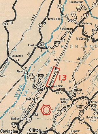
VA 18 Covington to Monterey
1933 Official
|
VA 18 replaced by US 220
1936 Official
|
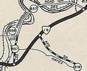
In May 1943 (CTB), VA 18 swapped routings with SR 657 just south of Covington.
VA 18 via SR 619
1936 Alleghany County
|
VA 18 swaps with SR 657
1958 Alleghany County
|
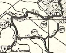
Also in May 1943 (CTB), VA 18 was removed from SR 697 and SR 698 at Arritt.
In Aug 1952 (CTB), the southern Craig County portion of VA 18 was straightened out to have fewer crossings of Potts Creek.
In March 1955 (CTB), VA 18 was removed from SR 786 and SR 787 near Potts Creek.
In Aug 1955 (CTB), VA 18 was removed from SR 788 near Blue Spring Run.
In July 1968 (CTB), VA 18 was straightened out on its northern Craig COunty route leaving behind abandoned routing.
In Dec 1987 (CTB), VA 18 was rerouted at the Mallow St area in Covington to its current overpass of the railroad, leaving behind Parkview Ct.
Improvements: Fully paved upon designation from Covington to Warm Springs; Vanderpool to West Virginia
In 1934, VA 18 was paved from Blue Springs to Covington; Warm Springs to the Jackson River bridge
About 1940, VA 18 was paved from Blue Springs south a few more miles.
Between 1942-44, VA 18 was paved to nearly the Craig County line.
In 1951, VA 18 was paved to the Craig line.
The Craig County portion of VA 18 was finally paved in 1953.
There are no multilane segments on VA 18.
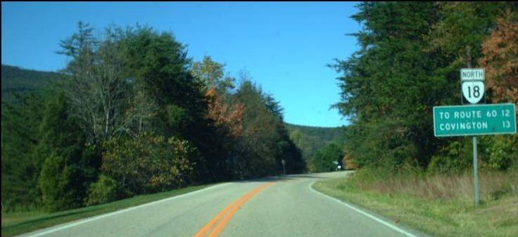
Posted: Fully posted; Cutouts in Covington remain as of 2011 as well as at SR 613 north of Jordan Mines.
Error US 18 shields have existed in Covington at US 60-220 back to at least 1991.
Multiplexes: None
Legislative names: None
Other names: Potts Creek Rd (s of Covington); Indian Valley Rd/S. Carpenter Dr (Covington)
Scenic Byway: No segments
Comment: VA 18 connects hard-to-reach Craig County to Covington.
VA 18 is blown off by I-64.
The 1939 VDOT report on primary system development recommended that VA 18 be decommissioned south of the Covington SCL (then at SR 657).
|
| Previous VA 18's:
1940 ROUTE LOG
NC STATE LINE: 0 - 0
VA 59: 3 - 3
US 58, VA 44: 11 - 14
VA 321: 1 - 15
VA 321: 3 - 18
VA 12 WB: 2 - 20
US 501 NB, VA 12 EB: 0.5 - 20.5
VA 303: 14.5 - 35
VA 20 WB: 8 - 43
VA 20 EB: 2 - 45
VA 323: 11 - 56
VA 43 WB: 10 - 66
VA 43 EB: 1 - 67
US 60 EB, VA 10 EB: 11 - 78
VA 319: 0.5 - 78.5
VA 10 WB: 1.5 - 80
US 29 SB, VA 14: 2 - 82
VA 311: 1 - 83
VA 317: 1 - 84
VA 13: 15 - 99
VA 312: 1 - 100
VA 313 SB: 9.5 - 109.5
VA 313 NB: 0.5 - 110
VA 314: 10 - 120
US 29 NB, VA 28: 7 - 127
VA 313: 6 - 133
VA 39: 10 - 143
| |
VA 18 #1: Began in January 1918 as an original state route defined by the general assembly:
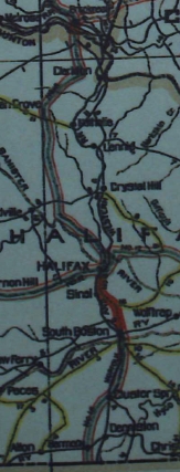
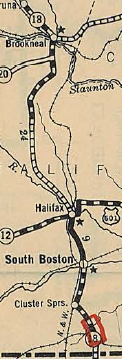
Route 18: Afton, Lovingston, Amherst, Lynchburg, Brookneal, Houston [this is now named Halifax], South Boston , North Carolina Line
This is how VA 18 ran:
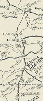
Began at the North Carolina State Line below Harmony, using SR 714 to SR 711 to Denniston, then SR 707 and SR 698 to Cluster Springs. VA 18 may have used SR 704 Old Cluster Springs Rd to South Boston but stopped doing so by 1923 if it did. Otherwise it used US 501 into downtown South Boston, then VA 129 back to US 501 and into Halifax.
VA 18 followed VA 360 east to SR 760 Martins Ferry Rd (no longer connects) to SR 626. VA 18 followed SR 626 corridor through Crystal Hill to Lennig. Note that VA 18 crossed the railroad 10 times between Halifax and Lennig, and some of those alignments are gone (probably used part of SR 831), then SR 603 and SR 644 to Nathalie. The 1922 Auto Trails maps shows it going to Clarkton before crossing into Brookneal at US 501. There are a couple ways this could've been accomplished, but the 1923 Official suggests it was SR 644 east to SR 626 north. VA 18 then used SR 785 Depot Ln and abandoned road to SR 632 northwest to US 501.
VA 18 used Old Main St/Main St to VA 40 at Brookneal, then west to pick back up modern 501. US 501 followed its current route to Rustburg except it used SR 612 Ebenezer Rd to SR 917 through Naruna. After Rustburg, VA 18 used SR 894 Kelly Rd, 501, and SR 898 Trestle Rd back to US 501. VA 18 followed US 501 except for Turf Rd (around SR 670) and SRs 1029/1030 (around SR 667).
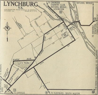
VA 18 used SR 664 west to SR 677 which becomes Martin St in southeastern Lynchburg. VA 18 used Old Courthouse Tpk (no longer connects) to Campbell Ave. VA 18 folled Campbell Ave to 17th east to Buchanan St north to Park Ave. VA 18 used Park to 5th then south on Main to cross the James River on 7th St.
VA 18 immediately cut east on SR 1015 Rocky Hill Rd, then north on SR 1004 Lynches Ferry Rd to SR 1006/1034 Main St through Madison Heights. VA 18 used VA 163, then US 29 Business except SR 680 Daniels Pl; SR 678 Highview Dr; SR 604/673 Crescent Ln north to Monroe. VA 18 picked up SR 671 through Five Forks, then 29 Bus, then Faulconerville Dr through Faulconerville. VA 18 then followed US 29 Business towards Amherst CH. If VA 18 ever SR 661 used Old Stage Rd around Sweet Briar it stopped doing so by 1923. VA 18 did however use Macadam Rd (no longer connects) to Garland Ave to 29 Business in Amherst CH.
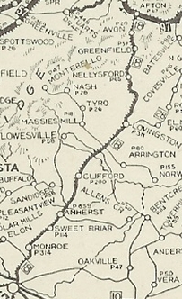
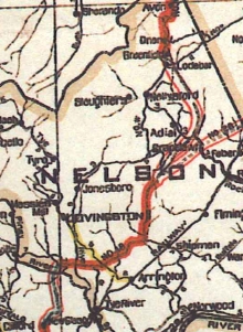
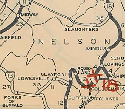
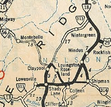
VA 18 followed 29 Bus to US 29, then VA 151 north. North of Clifford, VA 18 used SR 784 Canodys Store Rd and SR 785 Blue Ledge Loop Rd. In Nelson County, VA 18 used VA 56 east to Colleen. VA 18 used SR 787 Lena Rose Ln. It is difficult to ascertain if VA 18 initially went directly to Lovingston. Maps later in the 1920s clearly indicate VA 18 used SR 653/650 Oak Ridge Rd to VA 56 near Shipman then north to Lovingston via SR 650/722/abandoned route/745.
VA 18 followed US 29 Business through Lovingston, then used US 29 except SR 770 Cannery Loop to SR 624 Stagebridge Rd to SR 623 Myndus Rd through Old Myndus to SR 613 to Adial, then SR 634 west to Nellysford. VA 18 then followed VA 151 north except it used SR 612/613 loop and some abandoned routings near VA 6. VA 18 followed VA 6-151, then SR 638 Avon Rd back onto VA 6. VA 18 then ended at VA 9 (now SR 750 Old Turnpike Rd) in Afton.
By January 1923, VA 18 was rerouted at Halifax to use US 501 to Brookneal thusly: crossed the Bannister River slightly east of today's bridge, picking up Sedge Hill Trail, then modern 501, then abandoned routing, then SR 615 Dudley Rd and more 501. VA 18 used SR 610 Murphy Grove Rd and SR 643 Cedar Fork Rd. After some modern 501, the route used SR 643 McKendree Church Rd and SR 755 Bradley Rd. VA 18 used Parsonage Rd and Millstone Church Trail Loops.
Google Earth view seems to show a number of abandoned loops with no names heading northward. VA 18 used SR 907 Thorton Jim Trail and SR 851/761 Boxwood Rd approaching Volens then US 501 more or less to the Roanoke River.
In Jan 1923 (CTB), VA 18 was rerouted from Myndus to Afton to avoid Nellysford by using US 29 then VA 6/SR 810. Later some of this became part of the original VA 181.
In July 1924 (CTB), VA 18 was rerouted at Cluster Springs to follow today's US 501 plus SR 866 Woody Loop and SR 865 Whitt Loop down to the North Carolina line.
VA 18 original NC to Brookneal routing
1922 Auto Trails
|
VA 18 rerouted Halifax to Brookneal
1923 Official
|
VA 18 rerouted at NC Line
1928 Official
|
By 1924, VA 18 was removed from SR 612 and placed on US 501/SR 917 south of Naruna.
It appears by 1926, VA 18 was rerouted at Claypool to go north via today's VA 151 to Roseland, then SR 655 southeast back to Colleen.
Between 1925-28, VA 18 was rerouted in Lynchburg to use Campbell directly to Park.
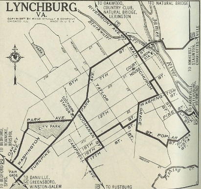
VA 18 original Lynchburg routing.
1925 Auto Trails
|
VA 18 removed from 17th/Buchanan
1929 Auto Trails
|
About Aug 1928, VA 18 was rerouted to avoid Shipman by using today's US 29/29 Business. Lovingston to Shipman became part of VA 314.
VA 18 original Lynchburg to Afton routing
1922 Auto Trails
|
VA 18 rerouted away from Nellysford
1923 Official
|
In Dec 1930 (CTB), VA 18 was placed on today's VA 163 north of the James River, leaving behind CR 20 and an extended VA 311.
About 1931, VA 18 was removed from SR 664/677 south of Lynchburg and placed on today's US 501.
About 1932, VA 18 was rerouted to avoid Roseland and instead used today's VA 56 to the Colleen area. The road north to Roseland became part of VA 313.
VA 18 via Roseland and Shipman
1929 Official
|
VA 18 direct to Lovingston
1932 Official
|
Also by 1932, VA 18 was moved onto today's US 29 Business from VA 163 to south of SR 671; Also onto US 29 Business through southern Amherst CH
In July 1933, VA 18 was renumbered:
US 501 from NC to South Boston
VA 129 from South Boston to the Loves Shop area
more US 501 north to Lynchburg
US 29 from Lynchburg to Woods Mill
VA 6 from Woods Mill to Afton.
|