< US 52 | Home | US 60 >
US 58 | US 58 Business |
US 158 | US 258
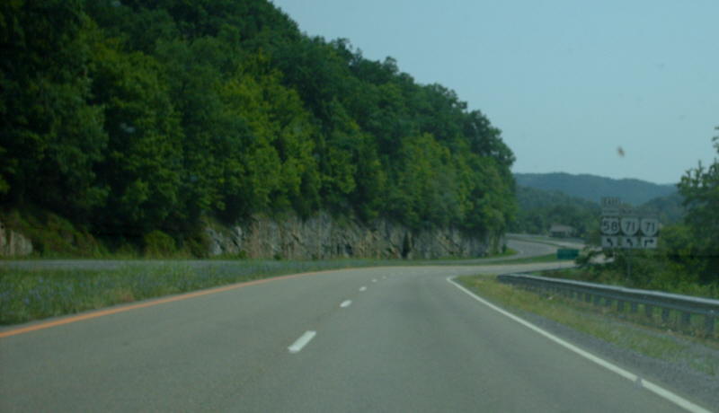
Photo: US 58 ALT nearing a VA 71 junction (photo by Mapmikey 8/18/07)
|
|
|
| ROUTE LOG |
US 58: 0 - 0 US 421 NB: 8.47 - 8.47 US 421 SB: 0.40 - 8.87 Wise-Lee Line: 13.73 - 22.60 US 23 Bus NB: 3.76 - 26.36 US 23 SB, US 23 Bus END: 1.52 - 27.88 Norton-Wise Line: 7.40 - 35.28 US 23 NB, VA 283: 2.52 - 37.80 VA 74: 0.80 - 38.60 Wise-Norton Line: 0.46 - 39.06 VA 158: 6.95 - 46.01 VA 72: 0.90 - 46.91 VA 158: 1.50 - 48.41 VA 63: 9.17 - 57.58 VA 270: 0.30 - 57.88 Russell-Wise Line: 0.48 - 58.36 VA 65: 2.56 - 60.94 VA 71 WB: 4.14 - 65.08 VA 71 EB: 1.46 - 66.54 US 19 NB: 6.71 - 73.15 Washington-Russell Line: 1.98 - 75.13 US 19 SB: 10.28 - 85.41 US 11 SB: 1.01 - 86.42 US 11 NB, VA 75 NB: 0.24 - 86.66 I-81 (exit 17), US 58, VA 75 SB: 0.78 - 87.44
|
Creation: Appeared about 1951. Ran generally as it does today, replacing VA 70 from Jonesville to St. Paul; VA 64 from St. Paul to Hansonville; Duplexed with US 19 from Hansonville to Abingdon. This is the 6th of 8 US 58 ALTs.
|
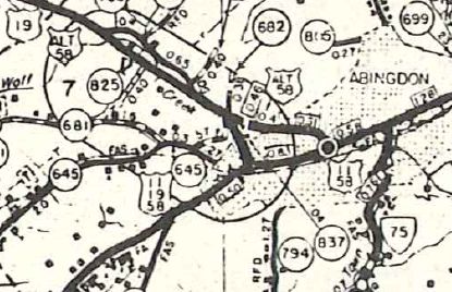
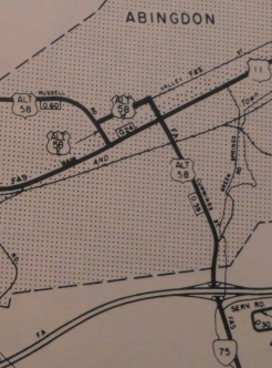
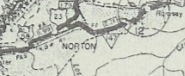
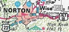
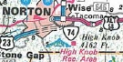
In May 1958 (CTB), US 58 ALT was rerouted in Norton. Initially, it followed Coeburn Ave to Park Ave to W. Park Ave. Now, it followed Kentucky Ave to 11th St North to Main Ave west/West Norton Rd. Coeburn Ave between Kentucky Ave and Park Ave became VA 74; Park Ave east of 11th remained part of US 23. West Park Ave became secondary. In Sept 1962 (CTB), US 58 ALT was removed from Main Ave/W. Norton Rd and instead followed 11th St north to Park Ave westward from Norton. In Dec 1965 (CTB), US 58 ALT was extended along VA 75 from Abingdon out to I-81 and the relocated US 58. Also it was proposed to place US 58 ALT on Valley Ave north of US 11 in Abingdon. Some county maps showed this reroute.
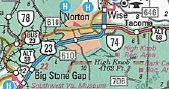
Around 1971, US 58 ALT was removed from SR 813 between Tacoma and Coeburn. In June 1988 (CTB), US 58 ALT was rerouted in Norton to use today's VA 283 and Park Ave west to 11th St south to the new US 23-58 ALT freeway. 58 ALT then used the freeway over to Big Stone Gap where it follows its current duplex with US 23 Bus north to town. Big Stone Gap to Norton remained part of US 23 Business; Kentucky Ave in Norton became secondary, but still posted in places in cutouts as OLD ALTERNATE US 58 as of 2018; Coeburn Rd became an extended VA 74. In Aug 1991 (CTB), US 58 ALT was removed from Norton altogether as the US 23-58 ALT freeway was finished around the east side of Norton. 11th Ave became secondary; Park Ave remained part of US 23 Business, and VA 283 was designated. VA 283 is posted as US 58 ALT Business on its eastern end.
In Aug 1999 (CTB), US 58 ALT was placed on new expressway around the south of Coeburn, leaving behind VA 158 and SR 893. About 2003, US 58 ALT was removed from Dryden Loop at Dryden. Through at least 2008 there were OLD US 58 postings at each end of the new bypass. Improvements: Paved at time of inception The first piece of US 58 ALT to be multilaned was Posted: Fully posted; An error VA 58 ALT shield existed for a while at the bottom of the I-81 NB ramp but is now gone as of 2009. Abingdon cutouts removed around 2000; A cutout in Big Stone Gap was still up in 2015; Several Norton cutouts remain Multiplexes: US 421 (0.40 mi) US 23 Bus (1.52 mi) US 23 (9.92 mi) VA 71 (1.46 mi) US 19 (12.26 mi) US 11 (0.24 mi) VA 75 (0.78 mi) Legislative names: Trail of the Lonesome Pine, from Jonesville to Big Stone Gap; Norton to VA 71 except VA 158/SR 893 (3-24-30 designation predates US 58 ALT); Orby Cantrell Highway, Big Stone Gap to Norton (since 2-25-83); Senator M.M. Long Highway, from Norton to Hansonville (since 3-13-01); Robert Porterfield Memorial Highway (Hansonville to Abingdon) Charles Bickley Memorial Bridge over Clinch River (3-27-40 designation predates US 58 ALT); Colonel Thomas McCullough Memorial Bridge over N. Holston River (3-6-42 designation predates US 58 ALT) Other names: Main St (Jonesville); Morgan Ave (Pennington Gap); Pennington Gap Hwy (Wise Co west of Big Stone Gap); Cumberland Ave/Wood Ave/E 5th St/Gilley Ave (Big Stone Gap); Norton-Coeburn Rd (Norton to Coeburn); Bull Run Rd (Coeburn to St Paul); Castlewood Rd (St Paul to Castlewood); Porterfield Rd/Russell Rd/Main St/Green Spring Rd (Abingdon) Scenic Byway: Jonesville to Big Stone Gap and Norton to VA 71 (since 3-8-93) Comment: US 58 ALT is part of the preferred corridor across the lower west of the state. This could easily be renumbered as mainline US 58, which is mostly duplexed between Jonesville and Abingdon. | Previous US 58 ALT's: |
US 58 ALT #1: Appeared between 1942-44 as a renumbering of VA 287, running on Turnpike Rd from US 58-460 (now US 58-460 ALT/VA 337) Alexanders Corner to US 58 High St within Portsmouth.
Although it is explicitly shown on VDOT Officials through 1974, it was officially renumbered as VA 337 ALT in March 1968 (CTB).
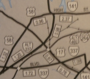
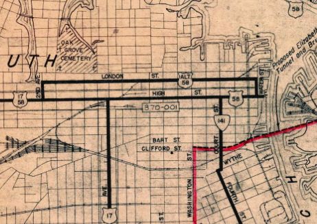
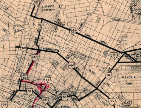
US 58 ALT #2: The Nov 1943 CTB shows a US 58 ALT being decommissioned (1.6 miles of Princess Anne Rd in Norfolk). Oddly, Officials from 1944-58 label this as US 58 ALT while the previous issue 1941-42 shows it as mainline US 58. The 1951 route log has it and the 1957 route log does not. The 1946 Norfolk County map shows US 58 ALT also running south on Bank St from Princess Anne back to US 58 near the ferry to Portsmouth. Whenever it did go away, Bank St remained part of US 460 ALT and Princess Anne St was removed from the state highway system, though the eastern end of this is now VA 404. US 58 ALT #3: Appeared Jan 1945 (CTB) as a proposed bypass in Danville. It opened as a road that stayed to the north of Dan River between the Union St bridge and today's VA 293. US 58 ALT was renumbered as mainline US 58 in Aug 1947 (CTB). Today it is part of US 58 Business. US 58 ALT #4: Appeared May 1945 (CTB) as a new routing in Portsmouth, running on London Blvd between Crawford and 2nd St, connecting to US 58 High St on both ends. US 58 ALT was probably decommissioned in Aug 1962 when US 58 was rerouted to the Midtown Tunnel. Today it is part of VA 141 which was put on London Blvd in 1968.
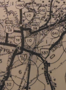
US 58 ALT #5: Created as a new routing in Suffolk by 1946, running from US 58 (now VA 337) on N. Broad St then east on Western Ave to end at US 58-460 Main St. I cannot find a CTB reference for the beginning of this route. In May 1953 (CTB), US 58 ALT was denumbered, as mainline US 58 was routed very nearby. The old routing of US 58 ALT crosses US 58 twice just west of VA 10-32.
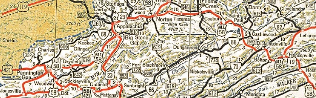
US 58 ALT #7: Appeared Feb 1951 (CTB) as a new routing in western Danville and Westover, as a limited access highway to be built. In Oct 1954 (CTB), US 58 ALT became mainline US 58 when the road was opened. Today it is the piece of US 58 Business between the two VA 51 junctions. US 58 ALT is shown on the 1954 Pittsylvania County map...
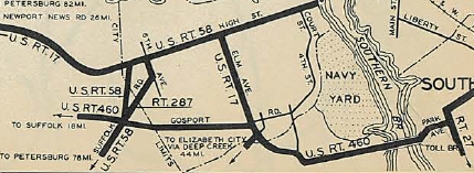
 US 58 ALT #7 1954 Pittsylvania County US 58 ALT #8: Appears on a VDOH map submitted as part of the May 1952 US 460 ALT AASHO application for Portsmouth-Norfolk. It was shown to run from then-US 58 ALT/VA 337 Bank St east through the upcoming interchange with US 460 coming fromn the Berkley Bridge to then-US 58 using Lovitt Ave. It does not appear this US 58 ALT was ever posted, though. When everything opened, the west half became US 460 ALT's routing and the east half was never put into the primary system. Today it is just City Hall Ave, though a small bit of US 460 ALT EB uses City Hall Ave between Bank St and I-264. See scan above. |
|||||||||||||||||||||

Previous: US 52 |
Next: US 60
US 58 | US 58 Bus
US 158 | US 258
Top | Virginia Hwy Index
Home
Page last modified 10 February 2022