< VA 59 | Home | VA 71 to 80 >
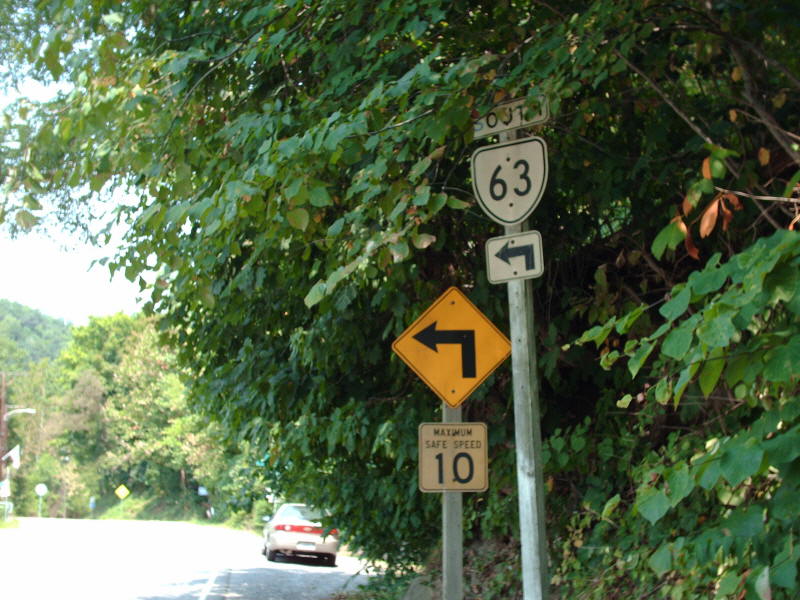
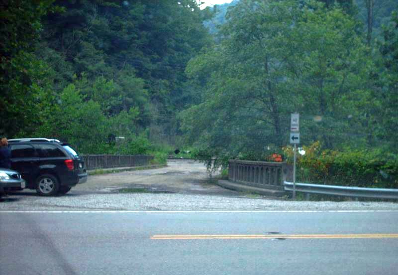
Photo: VA 63 southbound at SR 613 Haysi (photo by Mapmikey 8/18/07)
|
|
|
| ROUTE LOG |
VA 16: 0 - 0 US 19, US 460: 0.86 - 0.86 US 19 Bus, US 460 Bus: 1.29 - 2.15 Bland-Tazewell Line: 13.87 - 16.02 US 52 SB: 10.53 - 26.55 I-77 (exit 64): 0.06 - 26.61 US 52 NB: 0.40 - 27.01 Giles-Bland Line: 7.42 - 34.43 VA 100: 13.17 - 47.60 US 460: 0.56 - 48.16
|
Creation: Appeared in July 1933 as a renumbering of VA 127, running from VA 81 (now VA 16) Tazewell east to near the Bland County Line. This is the 2nd VA 61. The 1933 draft route log had this as VA 86
|
VA 61 only in Tazewell County 1933 Official Adjustments: In Sept 1934 (CTB), VA 61 was extended east to the Bland County line. In Sept 1942 (CTB), a second piece of VA 61 was created, replacing SR 641 from VA 8 (now VA 100) Narrows west 6.46 miles. In May 1943 (CTB), the second piece was extended west to the Bland County line over more SR 641.
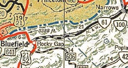
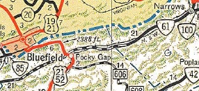
VA 61 now in Giles County, too. 1944 Official In May 1945 (CTB), the second piece was extended west to US 21-52 Rocky Gap over more SR 641. In June 1947 (CTB), the two pieces of VA 61 were connected via upgrade to the remaining SR 641.
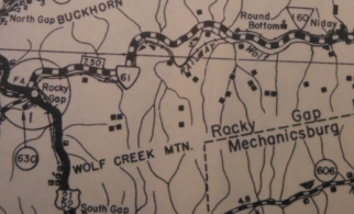
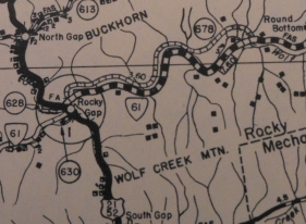
About 1947, VA 61 was extended over VA 8 across the New River from Narrows to the new US 460 (current frontage rd to 460). In April 1949 (CTB), VA 61 swapped routings with SR 678 between Rocky Gap and Round Bottom.
In March 1952 (CTB), VA 61 was moved onto its current bridge over the New River and US 460, leaving behind abandoned routing. In Jan 1964 (CTB), VA 61 was removed from SR 724 from Narrows west to Shumate. VA 61 was moved to the north side of Wolf Creek, over what had been SR 752. In July 1969 (CTB), VA 61 swapped routings with SR 724 between Chapel and Shumate. In Dec 1988 (CTB), VA 61 was rerouted at US 52 Rocky Gap to its present approach from Narrows, over new bridges and a little SR 675, the old route is a bit of SR 669 but the rest abandoned. Improvements: Paved upon designations in Tazewell and Giles Counties; In 1953 VA 61 was paved in Bland County east of Rocky Gap The rest of VA 61 was paved in 1954. VA 61 is multilane only at the I-77 jct, since about 1974. Posted: Fully posted; cutouts remain in Tazewell as of 2010; error US 61 shield up for several years leaving VA 16. Multiplexes: US 52 (0.46 mi) Legislative names: None Other names: Riverside Dr (Tazewell); Clearfork Rd (Tazewell Co); Clear Fork Creek Hwy (Bland Co w of Rocky Gap); Wolf Creek Rd (Rocky Gap to Narrows); Park Dr/Monroe St/McArthur Ln/Fleshman St (Narrows) Scenic Byway: None Comment: VA 61 is a fairly decent drive east of I-77. West of I-77 the ride has more sharp curves. The 1939 VDOT report on primary system development had recommended that VA 61 be decommissioned from SR 623 Burkes Garden Rd to its then-eastern end at the Bland County line. | Previous VA 61's: |
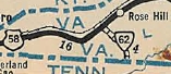
VA 61 #1: Appeared on the 1933 draft route log, running from US 58 Cumberland Gap south to Tennessee. This would've been a renumbering of VA 100. What is unusual about this designation is that the draft list did have all US routes with no state route concurrencies. So the fact this was part of US 25E is surprising, unless VDOH was somehow trying to eliminate US 25E. When the July 1933 map came out, VA 61 was actually assigned to its current routing. Also of note this showed a more logical pattern in the 1933 renumbering given where 62, 63 etc. were placed.
VA 61 at Cumberland Gap! 1933 draft route log VA 61Y: Appeared March 1952 when VA 61 was put on its new crossing of the New River at Narrows. The new bridge crossed the river and US 460. At the end of the bridge, roads curled off both directions to connect to US 460 (now the frontage road in this vicinity). The road curling north was VA 61Y. VA 61Y made it to at least 1975 but not long after because when US 460 was rebuilt as a 4-lane route through here, VA 61Y no longer touched US 460. Today it is just Fleshman St. | 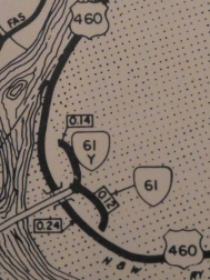 VA 61-Y 1975 Giles County |
||||||||||
|
|
|
| ROUTE LOG |
US 58, US 360: 0 - 0 NC STATE LINE: 4.01 - 4.01
|
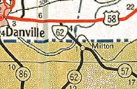
Creation: Appeared in May 1946 (CTB) as an upgrade to SR 726, running as it does today. This is the 3rd VA 62.
| Adjustments: In Oct 1951 (CTB), VA 62 was removed from an abandoned loop about a mile from the NC Line. Improvements: Paved upon designation; no multilane segments Posted: Fully posted Multiplexes: None Legislative names: None Other names: Milton Hwy Scenic Byway: None Comment: No excitement within Virginia, but on NC 62 north of Burlington there are several early 1920's bridges still in use. | Previous VA 62's:
1940 ROUTE LOG US 58: 0 - 0 TN STATE LINE: 3.70 - 3.70 1946 ROUTE LOG US 23, VA 70: 0 - 0 SR 600: 3.27 - 3.27 |
VA 62 #1: Appeared July 1933 as a renumbering of VA 101, running from US 58 Ewing south to the Tennessee Line.
|
||||||||||||||||||||||||||||||||||||||||||||||||||||
|
|
|
| ROUTE LOG |
US 58 ALT: 0 - 0 VA 270: 0.75 - 0.75 Russell-Wise Line: 0.85 - 1.60 Dickenson-Russell Line: 8.83 - 10.43 VA 83 WB: 13.90 - 24.33 VA 83 EB: 4.94 - 29.27 VA 80, VA 83: 10.01 - 39.28
|
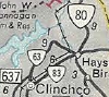
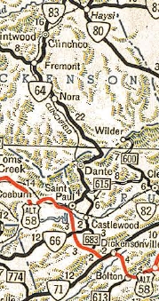
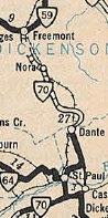
Creation: Appeared in March 1958 (CTB) as a renumbering of VA 64, running from St. Paul to VA 83 Fremont. This is the 2nd VA 63. See scan in VA 64 entry.
|
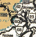
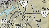
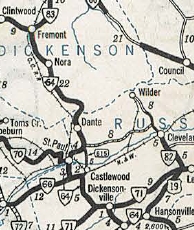
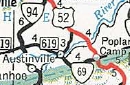
Adjustments: In 1966, VA 63 was extended east with VA 83 to Clinchco, then replaced VA 83 northeast to Haysi. This renumbering was authorized in the March 1961 CTB. In April 1986 (CTB), VA 63 was given its routing around Hamlin, leaving behind a bit of SR 619. In July 1986 (CTB), VA 63 was rerouted away from central St Paul (became VA 270 and instead continued west as new primary routing to US 58 ALT as it runs today.
Multiplexes: VA 83 (4.94 mi) Legislative names: None Other names: Wise St (St. Paul); Dante Rd (Russell Co); Dante Mountain Rd (Dickenson Co); Dickenson Hwy (VA 83 duplex); Big Ridge Rd (VA 83 to Haysi) Scenic Byway: No segments Comment: Not sure what utility the extension to Haysi really has. That portion of VA 63 is gnarly and difficult to drive. South of VA 83 is surprisingly nimble. | Previous VA 63's:
1940 ROUTE LOG US 58: 0 - 0 TN STATE LINE: 7.30 - 7.30 |
|
||||||||||||||||||||||||||||||||||||||||||||||||||||
| I-64 |
| VA 64 not currently assigned | |||||||||||||||||||||||||||||||||||||||||||||||||||||||||||||
| Previous VA 64's: 1957 ROUTE LOG US 58 ALT: 0 - 0 Russell-Wise Line: 2 - 2 Dickenson-Russell Line: 9 - 11 VA 83: 14 - 25 |
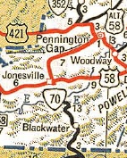
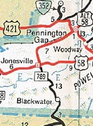
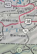
VA 64: Appeared July 1933 as a renumbering of:
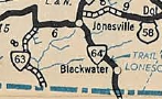
VA 103 from the Tennessee Line below Blackwater north to Jonesville
VA 64's initial routing from Lebanon southwest to Tennessee 1933 Official VA 64 used today's VA 70 from the Tennessee Line to about the Powell River, then abandoned alignments up to US 58. VA 64 used US 58 west, then US 58 ALT north of Jonesville to Ben Hur except it likely used SR 715, 716, and 760, plus it looks like some alignments have been destroyed.
|
||||||||||||||||||||||||||||||||||||||||||||||||||||||||||||
|
|
|
| ROUTE LOG |
US 23, US 58, US 421: 0 - 0 VA 72 SB: 14.72 - 14.72 VA 72 NB: 8.39 - 23.11 Russell-Scott Line: 5.10 - 28.21 US 58 ALT: 5.85 - 34.06
|
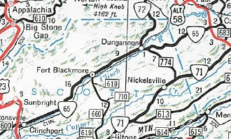
Creation: VA 65 was created March 1958 (CTB) as a renumbering of VA 66, running generally as it does now. This is the 2nd VA 65.
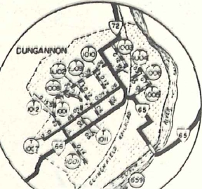
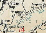
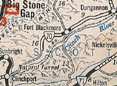
| Adjustments: In Feb 1970 (CTB), VA 65 was extended southwest from its original end (today's SR 883) to the relocated US 23-58-421 over what had been US 23-58-421. In Sept 1971 (CTB), VA 65 was removed from SR 828 near Banners Corner. In March 1979 (CTB), VA 65 was rerouted in Dungannon. Initially, VA 65 cut south at the curve south of SR 1007, then crossed the RR onto Emmet St which curls around to Washington St which used to cross the Clinch River, then VA 65 used SR 659 east to current VA 65. The new (current) routing replaced a bit of VA 72, then was new construction east across the Clinch River to meet up with existing VA 65 (now SR 659). Improvements: paved upon inception; no multilane segments. Posted: Fully posted; Multiplexes: VA 72 (8.39 mi) Legislative names: Heritage Bridge over Stony Creek (since 1-18-01). Other names: Clinch River Hwy (Scott Co); Veterans Memorial Hwy/Sinking Creek Hwy (Dungannon); Mew Rd (Russell Co) Scenic Byway: No segments Comment: Unlike the paralleling VA 71, VA 65 has some sections that are quite twisty, especially west of Dungannon. The 1939 VDOT report on primary system development had recommended that VA 65 (then-VA 70) be decommissioned from US 58 ALT southwest to SR 649 west of Fort Blackmore (entirety of VA 70 west of today's 58 ALT).
| Previous VA 65's:
1940 ROUTE LOG US 58, US 421: 0 - 0 VA 64 EB: 2 - 2 VA 66: 4 - 6 VA 64 WB: 1 - 7 KY STATE LINE: 8 - 15 1942 ROUTE LOG VA 66: 0 - 0 VA 70: 8 - 8 |
VA 65 #1: Appeared July 1933 as a renumbering of VA 104, running from US 58 Dot west through Pennington Gap to the Kentucky State Line. See scan under VA 64 entry.
|
||||||||||||||||||||||||||||||||||||||||||||||||||||
| I-66 |
| VA 66 not currently assigned | |||||||||||||||||||||||||||||||||||||||||||||||||||||||||||||
| Previous VA 66's:
1940 ROUTE LOG VA 64, VA 65: 0 - 0 VA 64: 6.06 - 6.06 1957 ROUTE LOG US 23, US 58, US 421: 0 - 0 VA 72: 22 - 22 US 58 ALT: 13 - 35 |
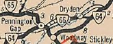
VA 66 #1: Appeared July 1933 as a renumbering of part of VA 103 running from VA 64-65 (now US 421) Pennington Gap northeast to Dryden.
In Aug 1936 (CTB), VA 66 was extended east 1.5 miles. In Sept 1937 (CTB), VA 66 was extended east to VA 64 (now SR 642). In Oct 1940 (CTB), VA 66 was renumbered as part of VA 70. Today it is US 58 ALT except it used OLD US 58 ALT through Dryden.
VA 66 #2: Appeared Oct 1940 (CTB) as a renumbering of VA 70 from VA 64 (now US 58 ALT) Banners Corner southwest to a few miles beyond Fort Blackmore where there was a break in the route. VA 66 also replaced VA 70 from US 23-58-421 Clinchport to Pattonsville, then duplexed with US 58-421 to Dot, then replaced VA 65 through Pennington Gap to the Kentucky State Line. 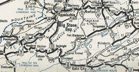
VA 66 #2 1941-42 Official In Sept 1942 (CTB), VA 66 was extended west 3.88 miles towards Clinchport over SR 645. In May 1943 (CTB), VA 66 was extended to US 23-58-421 (now SR 883) Clinchport over more SR 645. 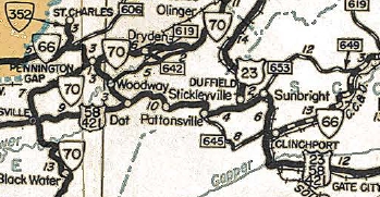
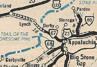
VA 66 completed plus removed from SR 645 below Pattonsville. 1944 Official Also in May 1943 (CTB), VA 66 was placed on US 58 from Pattonsville to Clinchport and was removed from today's SR 638 and SR 600. Around 1950, VA 66 west was truncated to Clinchport, replaced by US 421. VA 66 had used modern US 421 except SR 785 through Woodway, to Dot. Along today's US 58-421, VA 66 used SR 915 off Wallen Ridge, then SR 702 to Stickleyville. Then it used US 58-421 over Powell Mountain, then headed south on SR 638 through Pattonsville and east on SR 604 then modern 58-421 to Duffield. US 58 then followed SR 871 through Natural Tunnel back to modern US 58 via SR 872. US 58 used SR 882, abandoned routing, SR 883 to current VA 65. 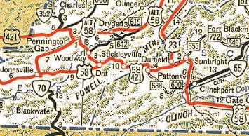
VA 66 west truncated to Clinchport 1951 Official In March 1952 (CTB), VA 66 swapped routings with current SR 683 east of Dungannon. In March 1958 (CTB), VA 66 was renumbered as VA 65, which it remains except: SR 828 near Banners Corner and its routing through Dungannon. VA 66 cut south at the curve south of SR 1007, then crossed the RR onto Emmet St which curls around to Washington St which used to cross the Clinch River, then VA 66 used SR 659 east to current VA 65. |
||||||||||||||||||||||||||||||||||||||||||||||||||||||||||||
|
|
|
| ROUTE LOG |
VA 80: 0 - 0 Tazewell-Russell Line: 10.44 - 10.44 US 460 WB: 1.61 - 12.05 US 460 EB, US 460 Bus Begin: 1.38 - 13.43 US 460 Bus EB: 0.89 - 14.32 US 460: 0.50 - 14.82 Buchanan-Tazewell Line: 7.54 - 22.36
|
Creation: Appeared in Oct 1940 (CTB) as a renumbering of VA 83 running generally the way it does now. This is the 2nd VA 67.
| Adjustments: In 1947 (CTB), VA 67 west was truncated to its current VA 80 jct. Originally VA 67 went further west to VA 80's original routing (now Clover Rd in Honaker). In Dec 1953 (CTB), VA 67 was removed from the SR 637 loops at Gardners. Sometime in the early 70s, VA 67 was placed on one-way splits with its now-US 460 Business Duplex through Richlands. In March 1954 (CTB), VA 67 was removed from the SR 670 loop west of Raven. Improvements: Fully paved upon inception; VA 67 was multilaned on its US 460 duplex in 1970. Posted: Fully posted; Multiplexes: US 460 (1.38 mi) US 460 Bus (0.89 mi) Legislative names: None Other names: Swords Creek Rd (Russell Co); Raven Rd (Tazewell Co w of US 460); Front St/Norfolk St/2nd St/Railroad St (Richlands); Jewell Ridge Rd (n of Richlands) Scenic Byway: None Comment: VA 67 is 23 miles long and has no 55 mph speed limits anywhere. 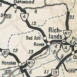
Current VA 67 1941 Official | Previous VA 67's:
1940 ROUTE LOG US 23, VA 64: 0 - 0 KY STATE LINE: 8 - 8 |
VA 67 #1: Appeared in July 1933 aS a renumbering of part of VA 106, running from US 23/VA 64 (now US 23 Business) west to the Kentucky line on top of Black Mountain.
| 
VA 67 #1 1933 Official |
|||||||||||||||||||||||||||||||||||||||||||||||||||
| I-68 |
|
|
|
| ROUTE LOG |
US 23 Bus: 0 - 0 Lee-Wise Line: 6.13 - 6.13
|
Creation: Appeared in July 1933 (CTB) as a renumbering of VA 119 running generally the way it does now. This is the only VA 68.
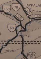
| Adjustments: About 1986, VA 68's eastern end was reconfigured. From 1933-86, VA 68 met US 23 about a half-mile south of where it does now. VA 68 was placed on newly constructed route over to VA 160, then replaced VA 160 over to US 23 Business. It appears the CTB did not formally make this change until 1999 but the bridges are dated 1986. The 1988 Official shows the change as well. Improvements: Fully paved upon inception; no multilane segments Posted: Fully posted; Multiplexes: None Legislative names: None Other names: Exeter Rd. Scenic Byway: None Comment: I'm guessing it was envisioned to connect this to KY 38 at some point (as opposed to US 421 way far away), but nothing has ever occurred in Lee County with this.
Previous: VA 59 |
Next: VA 71 - 80
Page last modified 27 March 2022 | ||||||||||||||||||||||||||||||||||||||||||||||||||||||
