<US 660 | Home | US 701 >
US 666 Bus |US 666 Temp |US 666-Y |
US 66 | US 166 | US 266 | US 366 | US 466 | US 566
US 666 at US Ends.com
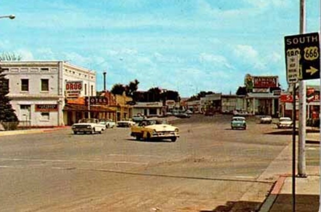
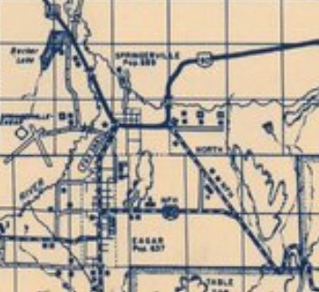
Photo: US 666 in Springerville AZ (postcard)
| US 666 renumbered in stages | ||||||||||||||||||||||||||||
| Previous US 666's: Final ROUTE LOG I-40: 0 - 0 US 64 WB: 91.2 - 91.2 US 64 EB: 0.9 - 92.1 CO STATE LINE: 15.3 - 107.4 US 160 WB: 6.4 - 113.8 US 160 EB: 19.7 - 133.5 UT STATE LINE: 43.2 - 156.7 US 163, US 191: 17.0 - 173.7 |
US 666: An original US Highway that in December 1926 ran from US 66 (now NM 118) Gallup NM to US 450 (now State St) just east of Cortez CO. This was a renumbering of US 660.
US 666 replaced NM 32 from Gallup to Shiprock and was an addition to CO 106. Thw distance was reported to AASHO as 141 miles.
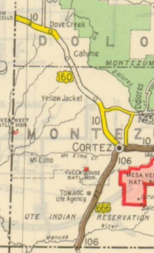
About 1930 (CDOT), US 666 was given a direct route south of Cortez CO in lieu of stair-stepping. Best guess is the original route used CR 21 to County Rd F which is cutoff by the Cortez Airport to CR 23 north which is also cutoff by the airport and is Airport Rd on the other side to County Rd G back to current US 491. About 1937, US 666 north was truncated to the west side of Cortez as US 160 (old US 450) was rebuilt from Yellow Jacket directly to Cortez.
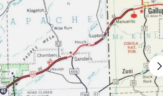
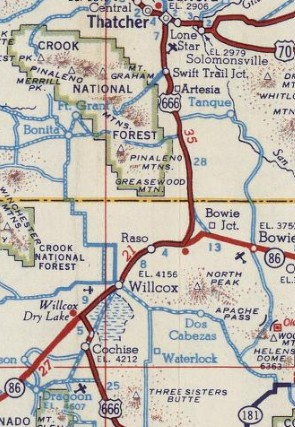
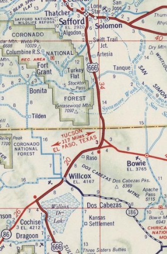
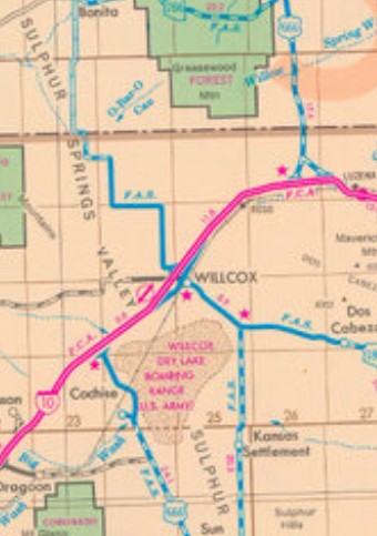
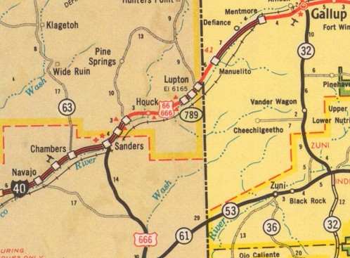
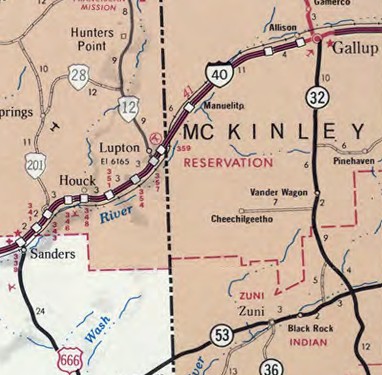
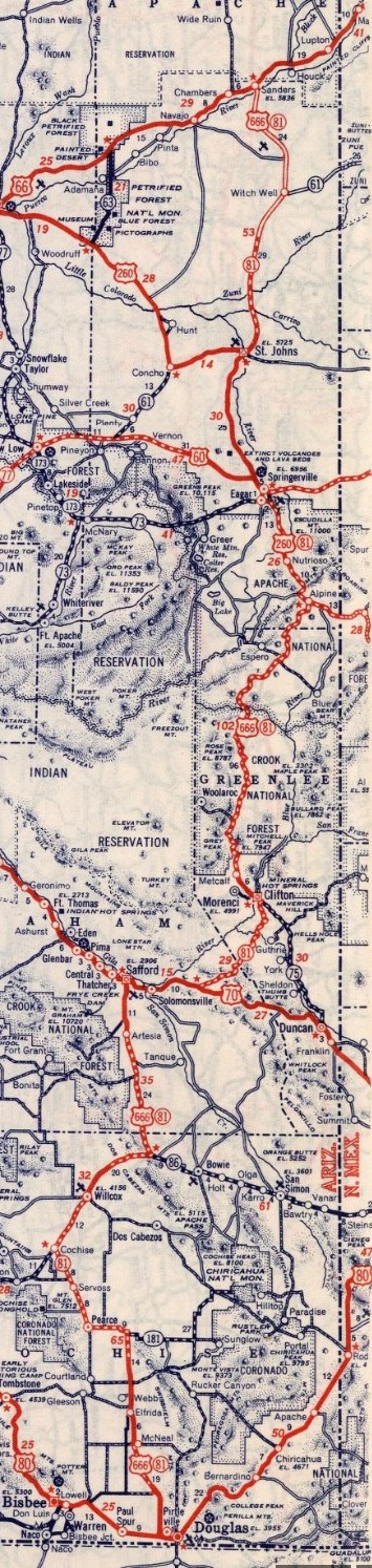
Also by 1937, US 666 was removed from CR 7 through Gramerco NM. In December 1938 (AASHO), US 666 was extended from Gallup to Sanders AZ along US 66, then replaced AZ 81 south all the way to US 80 (now AZ 80) at Douglas AZ. There was a lot of chatter around this extension...advocacy groups suggested redesignating US 666 as US 87 ("where it belongs") or US 187. AASHO wasn't convinced AZ 81 was up to standards or had enough traffic. Arizona had briefly requested most of this route be an extended US 87 in April 1934 but rescinded the request in May 1934 and AASHO replied the corridor was in no shape for an upgrade anyhow. In July 1939, AASHO turned down a request to extend US 666 north by following US 160 to Durango; US 550 to Montrose; US 50 to Grand Junction; US 6-24 to Rifle; CO 13/WY 330 to Creston WY; US 30 to Rawlins; US 287 to Lander; WY 320 to Riverton; US 26 to Shoshoni; US 20 to Greybull; US 310 to Laurel MT; US 10-12 to Billings; US 87 to Great Falls; US 91 to Canada at Sweetgrass. About 1942 (bridge date), US 666 was removed from S. Railroad Ave between the Cochise AZ railroad bridge and Willcox, plus a bit of S Arizona Ave.
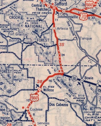
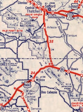
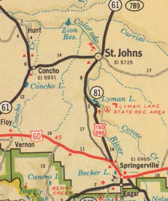
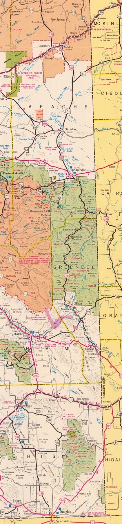
In April 1946, AZDOT passed a resolution to reroute US 666 to follow AZ 61 to Show Low; US 60 to Florence Jct; US 80-89 (now AZ 79) to Tucson. I did not find any documents showing they requested this from AASHO, nor anything rescinding the reroute by AZDOT, nor anything saying what the route from St Johns to Douglas would've become. About 1947 (bridge date), US 666 was given a cutoff to avoid Bowie Jct heading south towards Willcox. The old route south and east to then-AZ 86 was nearly completely abandoned. Only the southeastern 1.25 miles leading to AZ 86 remained as part of an east leg. Note that today only about 100 ft of today's US 191Y was part of this original US 666 routing. The north interesection between old/new US 666 was actually in Graham County and there were new alignments north of there as well. On the Bowie Jct end the road used to meet near the end of the I-10 WB on-ramp from US 191-Y. About 1951 (bridge date), US 666 was removed from Old US 70 east out of Safford AZ. Between 1952-56, US 666 was removed from Eldridge Rd and Cochise Stronghold Rd in Cochise AZ. About 1955, US 666 was straightened out in the Gramerco NM area leaving behind two abandoned segments; also just north of Yah-Ta-Hey leaving behing two abandoned segments About 1957 (bridge date), US 666 was straightened out in two places between Cortez and the NM line: just below the Mancos River (no real change in distance) and about 2 miles north of US 160 junction (0.2 miles shorter). About 1958, US 666 was straightened out at Tohatchi NM leaving behind two abandoned segments. About 1961 (bridge dates), US 66-666 was placed on I-40 between Arizona Exit 354 and the NM State line. Most of the surviving old road is the EB Frontage Rd. Also about 1961, US 666 was straightened out 4 miles east of Tohatchi NM leaving behind an abandoned segment. In July 1962 (AASHO), US 666 was extended with US 80 into Douglas, then replaced AZ 666 to the Mexican Border. About 1962 (bridge dates), US 666 was removed from US 60 and the lengthy CR 4365 north of Springerville and also from CR 6329 south of St. Johns AZ. About 1963 (bridge dates), US 66-666 was removed from today's NM 118 and placed on I-40 between Exit 8 and Exit 16. About 1964 (bridge dates), US 66-666 was placed on I-40 in the Sanders AZ area.
In July 1966 (AASHO), US 180-666 was rerouted at Springerville to avoid Eagar. This left behind US 180 Business (now Main St and AZ 260).
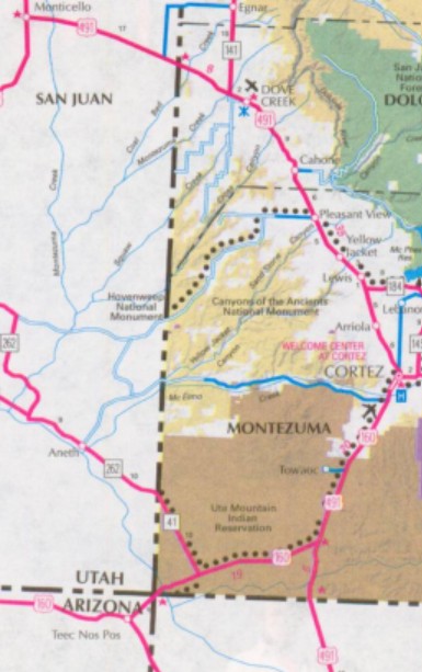
About 1967 (bridge dates), US 66-666 was placed on the completed I-40 between Sanders AZ and Exit 354. Some of the surviving old road is the WB Frontage Rd. In April 1969 (AASHO), Colorado/New Mexico/Arizona/Utah requested numbering changes/additions in the 4-corners region. For US 666 this was a request to extend it from Cortez CO to Monticello UT, replacing US 160. In October 1969, AASHO responded by saying US 666 from Gallup NM to Cortez CO was now a new US 163. In November 1969, the four states balked at the AASHO-approved changes, which affected other US routes in the original application as well. In December 1969, AASHO countered with a suggestion to not renumber US 666 as US 163 but to instead extend it even further north from Monticello UT, replacing more of US 160 to end as US 6-50 Crescent Jct UT. In February 1970, the states submitted a new proposal which would end US 666 in Monticello and US 163 would instead run to Crescent Jct as part of the new corridor running to Kayenta AZ. In June 1970, AASHO accepted this and US 666 north was extended to US 163 (now US 191) Monticello UT. About 1970, US 666 was placed on I-10 around Willcox AZ, leaving behind I-10 Business. The rest of the I-10 overlay was built directly on top of US 666/AZ 86.
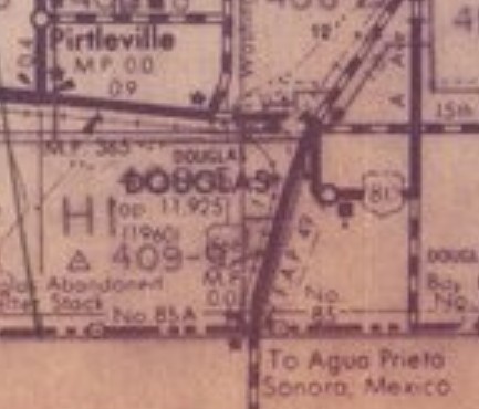
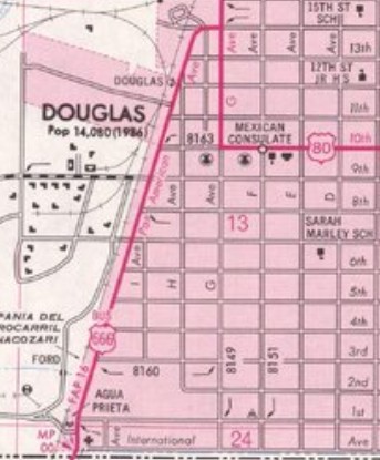
In 1971 (AZDOT), US 666 south was truncated back to its US 80 junction west of Douglas, leaving US 80 (now AZ 80) to Douglas and US 666 Business (now US 191 Business) from 80 to the International Border.
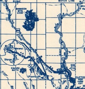
In 1973 (AZDOT), US 666 from the first hairpin north of Clifton to about Chester Gulch was abandoned as the highway was rerouted to accomodate the Morenci Mine. The new route was US 666 Temp on maps and in logbooks, while US 666 had a gap of the same length in the logs. This new routing used existing roadway (still used by US 191 Temp) to just before the second tunnel, then used a private road that has now been again bypassed. Some of Eagle Creek Rd was the route; a tiny bit of the current route just past the bridge over mine roads; the northernmost 3/4 mile of the original 1973 bypass route. No part of the pre-1973 routing really survives as it was destroyed as part of the expanding mine.
Also about 1973, US 666 was straightened out near the McKinley/San Juan County NM line leaving behind an abandoned segment About 1974 (bridge date), US 666 was given a bypass around the west side of Gallup to meet I-40 at today's Exit 20. The old route used NM 608/N. 9th St, NM 609/Maloney Ave, and S. 3rd St.
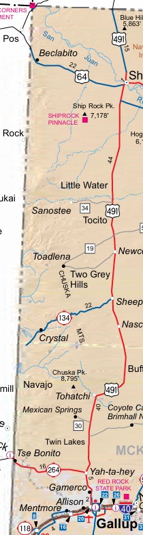
About 1975, US 666 was removed from the frontage road and a lengthy abandoned segment in Tohatchi NM and northward. About 1976, US 666 was removed from the frontage road and abandoned segments around Sheep Springs NM. About 1979, US 666 was removed from the frontage road and abandoned segments around Newcomb NM and northward. About 1981, US 666 was removed from CR 8575 and multiple abandoned segments around Little Water NM and both directions. In 1984, US 666 was removed from Picnic Creek Rd east of Eagar AZ. In June 1985 AASHTO turned down a request to extend US 666 beyond Monticello UT by following US 191 to Blanding; replace AZ 95 to Hanksville; replace UT 24 to Glenwood; replace UT 119 and a bit of UT 118 to Richfield; replace UT 120 to I-70. About 1986 (bridge date), US 666 was removed from Yah-Ta-Hey Loop at the NM 264 interchange area. In May 1987 AASHTO turned down a request to extend US 666 as proposed in 1985, but this time stay with UT 24 to end at I-70 Sigurd UT. In June 1992 (AASHTO), US 666 was renumbered as US 191 from Douglas AZ to I-40 at Sanders AZ; dropped from I-40 from Sanders to Gallup NM.
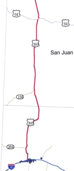
In May 2003 (AASHTO), US 666 was renumbered in its entirety as US 491. The states involved had actually requested US 393. A leading factor for this was sign theft. It took Colorado over 10 years to reflect this on their maps.
| |||||||||||||||||||||||||||


Previous: US 660 | Next: US 701
US 666 Bus |US 666 Temp |US 666-Y |
US 66 | US 166 | US 266 | US 366 | US 466 | US 566
US 666 at US Ends.com
Page last modified 30 December 2025