<US 460 | Home | US 470 >
US 66 | US 166 | US 266 | US 366 | US 566 | US 666
US 466 at US Ends.com
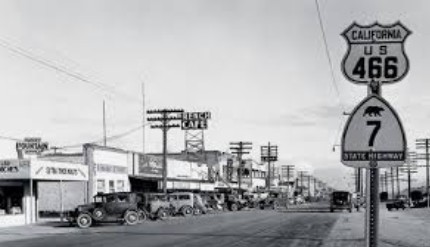
Photo: US 466 in Mohave CA before US 6 came along (Facebook)
| US 566 truncated, then renumbered | |||||||||||||||||||
| Previous US 466's: Final ROUTE LOG (466 #1) US 70: 0 - 0 US 66: 35 - 35 Final ROUTE LOG (466 #2) US 70: 0 - 0 US 66: 41 - 41 Final ROUTE LOG (466 #3) I-15 SB: 0 - 0 NV STATE LINE: 49 - 49 I-15 NB: 12 - 61 US 91 NB, US 93 NB, US 95 NB: 31 - 92 US 95 SB: 20 - 112 AZ STATE LINE: 11 - 123 US 66, US 93 SB: 72 - 195 |
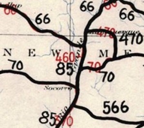
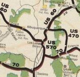
US 466 #1 and #2: The change of US 60 to US 66 while also adding several small US routes that were to be x60 or x66 numbers all at the same time in 1926 produced a bewildering trail of correspondence where letters are dated to take actions that had already been rearranged earlier. The 1925 original plan had US 460 assigned to run from US 60 (now NM 6) Los Lunas NM south to a point on US 70 (now an abandoned route south of present US 60).
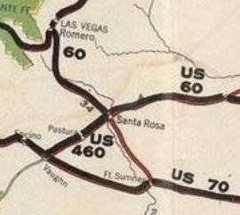
In January 1926, AASHO approved another short route with no number assigned to run from US 70 (now abandoned alignment between US 285 and the railroad) Vaughn NM to US 66 (now I-40 Bus) Santa Rosa NM. In February 1926, several states requested this Vaughn-Santa Rosa route be a part of a much longer US 54. This was blocked by Cyrus Avery of Oklahoma. In July 1926, AASHO voted to make the Vaughn-Santa Rosa route US 460 and renumber the Los Lunas US 460 as US 570. Although the change from US 60 to US 66 was formally announced in August 1926, July ballots for renumbering the Los Lunas segment were changed to read renumbering US 466 as US 570. So somewhere US 460 #1 got redesignated as US 466 #1. Today this is US 85 from Los Lunas to Belen; NM 304 to Casa Coronado; headed southeast from NM 304 on Benavidez Rd and went straight 1.1 miles (Google maps shows Benavidez Rd wandering south before here). US 466 then bent to ESE for another 1.9 miles to what Google Maps labels as Escobar Pl. Here US 466 turned SSE in a straight line 2.6 miles to what Google Maps label as Verde Ave. US 466 then headed just slightly west of due south into Socorro County for a total of about a mile. US 466 headed SW to cross an arroyo for 0.3 miles to nearly what Google Maps labels as Pedro Place, then headed SSE in a straight line, crossing US 60 after 5 miles and after 0.4 more miles, then turns due south for 2.9 miles to where the road bends southwest again. Here is where it intersected then-US 70, which came from the northeast and continued southwest to Sorocco. After leaving Benavidez Rd, the only part of US 466 that appears truly drivable is the part south of US 60 (Luna Rd) which is gated off as private property. 95% of US 466's route southeast of Casa Colorado is still discernible on current satellite views.
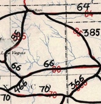
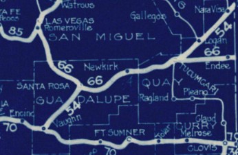
In late August, AASHO notified New Mexico that the US 60-66 change necessitated renumbering x60 routes as x66. Therefore, the Vaughn-Santa Rosa segment was renumbered from US 460 #2 to US 466 #2. Confusion also surrounds when US 466 #2 became US 54. There are maps dated Nov 11, 1926 that show it as US 54. However, there is February 1927 AASHO correspondence that says US 54 still ended at Tucumcari NM. Today this is abandoned routing running 2800 ft northeast to the current US 54-60 junction; abandoned routing east of US 54 for 6.3 miles that bows eastward up to about a mile before joining US 54; followed US 54 for about 8.7 miles; abandoned alignment along the RR, using Aragon/1st St through Pastura; abandoned along the RR to where the RR turns north towards Arabella then abandoned northeast about 2.5 miles to cross US 54 and curl alongside the east to about Gavilan Rd; US 54 to Santa Rosa. No map I have seen shows US 466 #1, but an interim 1926 AASHO map showing before and after numbering in New Mexico does show US 466 #2.
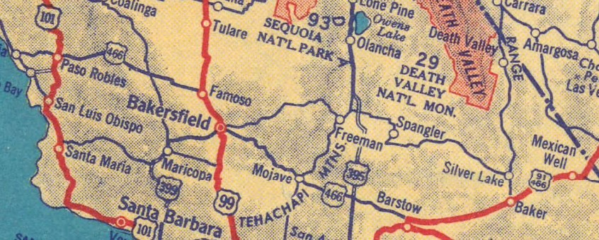
US 466 #3: Created July 1933 (AASHO) as a consolation prize after AASHO declined to extend US 64 from Santa Fe NM to Morro Bay CA (involving several hundred miles of duplex with US 66). AASHO members were given a choice of approving US 64 out to California or a US 466 from Barstow west to Morro Bay. after they chose the US 466 creation, California wasn't fully sold on US 466 being the outcome and in August 1933 asked AASHO to hold off on publicizing the new route. No further correspondence is in the file until October 1933 when AASHO was seeking states' confirmation of their portion of US 466 from Morro Bay to Kingman AZ. It ran from CA 1 (now Main St) Morro Bay to US 66 (now 4th/Andy Devine intersection) Kingman. Morro Bay to North Barstow was new posted routing except for a US 99 duplex between Bakersfield and Famoso. North Barstow to Las Vegas was an addition to US 91.
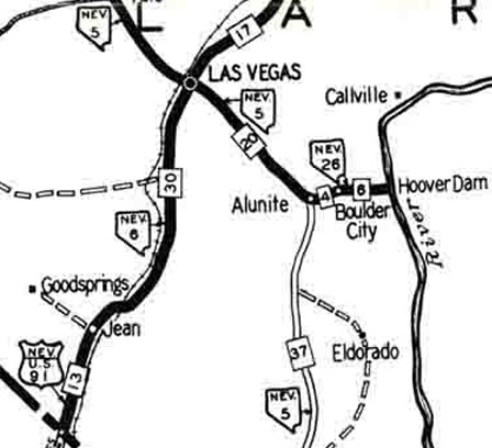
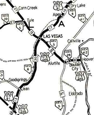
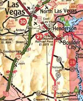
 1935 Shell Las Vegas to Alunite replaced NV 5; Alunite to Boulder City; Boulder City to Hoover Dam replaced NV 42
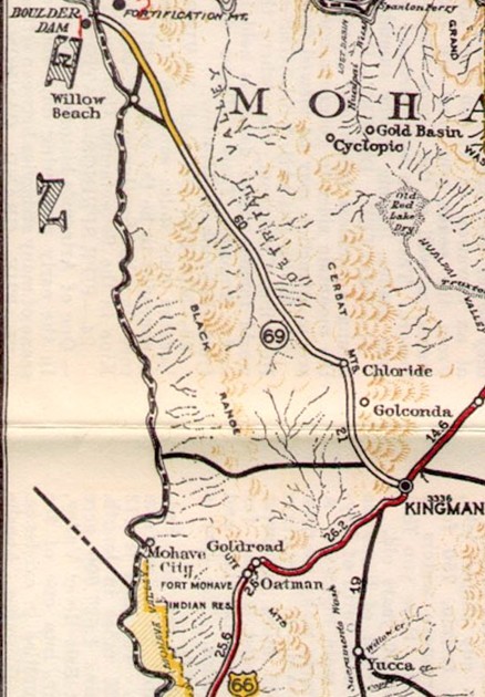
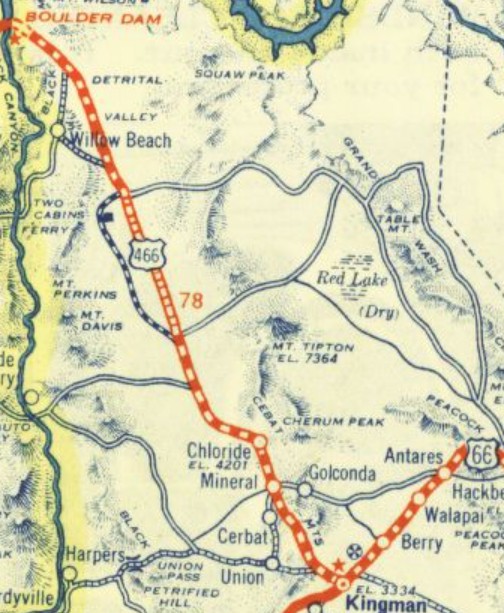
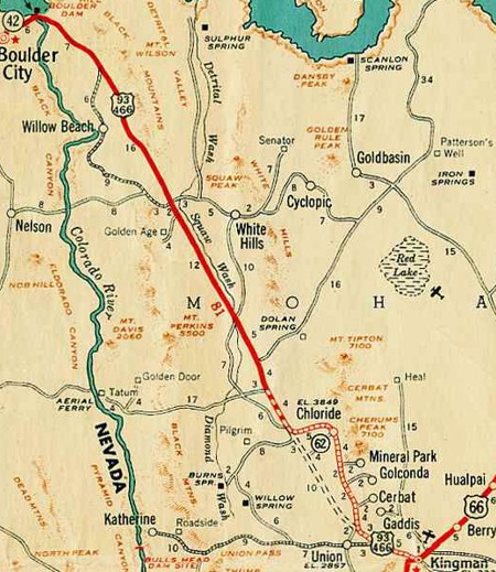
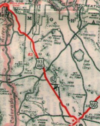
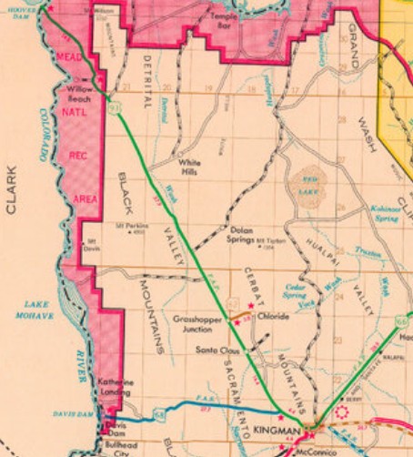
In Arizona, US 466 replaced AZ 69 from Hoover Dam to Kingman AZ.
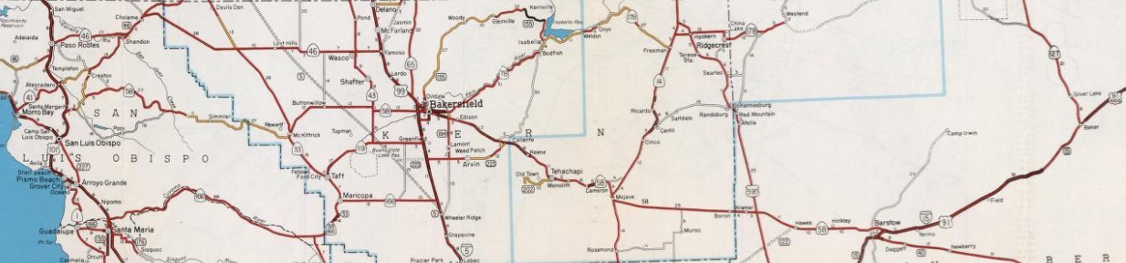
In June 1934 (CHPW), US 466 was placed on Golden State Ave at Baker St to continue on Sumner St to Golden State Ave through Bakersfield CA. The original route used Baker/Grove/19th St/Chester Ave/Roberts Ln. In 1935, US 93 was added to the entirety of US 466 from Kingman to Las Vegas. About 1936, US 466 was removed from Famoso-Woody Rd and C St through Famoso CA. Between 1936-38, Neumarket Rd at Sivert CA in a square loop that no longer connects back to Bena Rd at the big curve. If US 466 ever used abandoned/Hart Flat Rd near Rowen CA it stopped doing so by 1938. In 1938, US 466 received a bypass of Chloride AZ, leaving behind a jeep trail that starts 1200 ft south of Big Wash Rd heading east to become Silverhill Rd/Old Chloride Rd/Chloride Rd/Tennessee Ave to Chloride, then 2nd St/Old Boulder Dam Hwy south down to Champion Mine Rd; abandoned routing to the Golden Valley Area)
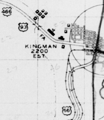
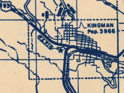
About 1939 (AZDOT), US 466 east was truncated to the west end of Kingman where a new Y intersection was built roughly where Andy Devine splits to Beale St and Old US 66. US 466 had used Beale/2nd/Main to end at 4th. US 66 was rerouted to stay on Main all the way through, replacing US 466.
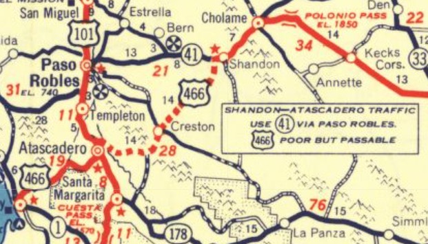
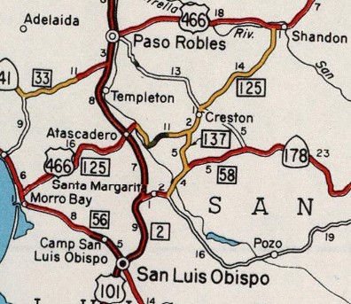
By 1947, US 466 was removed from abandoned/Rockhouse Dr in the Warren CA area. In May 1956, AASHO turned down a request to add US 66 ALT to US 466 from Barstow CA to Kingman AZ. AASHO's internal memo noted that there was no indication any of the 3 states were tryig to replace US 466. In June 1958 (AASHO), US 466 was rerouted in California between Atascadero and Shandon. US 466 now headed north with US 101 to Paso Robles, then replaced CA 41 east to Shandon. The original route, which California said was substandard to the point that it had never been posted as US 466, remained part of legislative route 125 for a time. Today this is abandoned/Capistrano Ave leaving Atascadero; Sycamore Rd to Acacia Rd where US 466 used to cross the Salinas River; Rocky Canyon Rd southeast to Halcon Rd, then northeast to where the road ends at a quarry; US 466 followed Rocky Canyon Trail east which eventually becomes a road again about 1.3 miles later as more Rocky Canyon Rd to CA 229; US 466 followed CA 229 through Creston to just past Iron Gate Rd, then abandoned routing east to La Panza Rd then Little Farm Rd to CA 41; US 466 followed CA 41 to west of Shandon, then Centre St through Shandon. The Atascadero to Shandon routing of US 466 is profiled by Gribblenation.org, including more detail and plenty of photos.
US 101 was already on its current routing from Atascadero and around Pendleton, but its Paso Robles bypass may not have been opened yet, so US 466 might have very briefly used Spring St and 13th St west of the US 101 freeway. Also around this time, the current CA 46 alignment east out of Paso Robles was built, so US 466 may have briefly used Union Rd between US 101 and Paso Robles Blvd. Between 1952-59, US 466 was removed from Kramer Sta Rd/abandoned across the RR in Kramer; also Dixie Rd across the RR in Hinckley CA. About 1959, US 466 was added to I-15 between Primm NV and Jean NV, leaving behind Las Vegas NV. In 1960, US 466 was removed from Shandon Rd and Centre St through Shandon CA. Also in 1960, US 466 was given a much more direct route between current Exit 123 on CA 58 and Bealeville Rd past CA 223. The old route is the lengthy and winding Bena Rd. About 1961, US 466 was added to I-15 from Exits 186-189 north of Barstow; I-15 from Exit 248 above Baker to Exit 272 Cima Rd In October 1962, AASHO denied a request from California to eliminate US 466 in its entirety because Nevada didn't send a request to also truncate it. About 1962, US 466 was removed from Woodford-Tehachapi Rd/Valley Blvd/S Curry St from Keene CA to Tehachapi CA. Between 1958-63, US 466 was removed from about 4.4 miles of abandoned alignment starting directly south of the modern CA 41/46 interchange that crossed over CA 46 near the Polonio Pass Pumping Plant to rejoin the route very near the Kerr County Line. About 1963, US 466 was added to I-15 from Exits 189-213, leaving behind Outer Hwy 15 N/Yermo Rd through Yermo; Exit 272 Cima Rd to Primm NV; Sloan NV to S. Las Vegas, leaving behing more Las Vegas Blvd In June 1964 (AASHO), US 466 west was truncated to CA 127 at Baker. Morro Bay to Atascadero became part of CA 41; Atascadero to Paso Robles remained US 101; Paso Robles to Famoso became CA 46 (except about 4 miles abandoned alighment leading to Cholame CA, Old CA 46 in Cholame; 2.5 miles more abandoned routing through the old CA 41/46 split to a little past the current CA 41/46 interchange); Famoso to Bakersfield remained CA 99 (except Golden State Hwy between Exits 29-31); Bakersfield to Barstow became CA 58 (except Sumner St/Truxtun Ave/Edison Hwy leaving Bakersfield until Exit 123; Tehachapi Blvd through Techahapi and Monolith; Cameron Canyon Rd through Cameron; abandoned along RR/CA 58 Bus/20th St through Mojave; abandoned/Twenty Mule Team Rd through Desert Lake, Boron, Kramer, and Kramer Jct; Old CA 58/abandoned/Santa Fe Ave through Hinckley; lengthy Old Hwy 58 through N. Barstow); Barstow to Baker remained US 91 (today this is Old Hwy 58 out of N. Barstow; I-15 from Exits 186-245; Baker Blvd into Baker). Note that Arizona removed US 466 from its state highway map in 1966.
 1965 Official About 1965, US 466 was moved to I-15 between CA 127 and Exit 248; also removed from White Rock Canyon Trail Access/2 east abandoned alignments and 1 west one southeast of Hoover Dam About 1967, US 466 was removed from a lengthy abandoned alignment east of Willow Beach Scenic Overlook AZ. The road that bypasses Boulder City goes back to the construction of Hoover Dam in the 1930s. However, the first definitive Nevada map that shows US 466 was moved to it was 1970. The old route used Nevada Way. In December 1971 (AASHO), US 466 was decommissioned entirely, leaving behind I-15/US 91 in California; I-15 to Jean NV; US 91 to Las Vegas (now Las Vegas Blvd); US 93 to Kingman AZ (now NV 582 through Henderson; a little I-11; abandoned; US 93 Bus through Boulder City; NV 172 and the Hoover Dam Access Rd, across the dam and the closed Hoover Dam Access Rd back to I-11 Exit 2 in Arizona; US 93 to I-40, then Beale St and Andy devine to Old US 66)
| ||||||||||||||||||
Previous: US 460 | Next: US 470
US 66 | US 166 | US 266 | US 366 | US 566 | US 666
US 466 at US Ends.com
Page last modified 7 February 2026