<US 660 | Home | US 701 >
US 666 |US 666 Bus |US 666 Temp |
US 66 | US 166 | US 266 | US 366 | US 466 | US 566
US 666 at US Ends.com
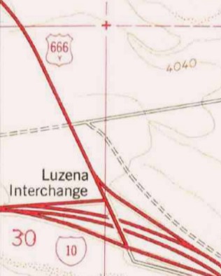
Photo: This 1979 Topo actually has a 666-Y shield
| US 666-Y collateral damage | ||||
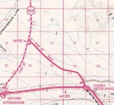
| Previous US 666-Y's: Final ROUTE LOG I-10 (Exit 355): 0 - 0 US 666: 3.4 - 3.4 |
US 666-Y: Created 1958 (AZDOT) as new primary routing, running from AZ 86 (now I-10) near Bowie Jct west to US 666. Although US 666 had met AZ 86 at that location up to around 1947, US 666-Y only utilized about 1.25 miles of old US 666 west off AZ 86 with the rest west to modern US 666 being new construction. The pre-1947 US 666 routing actually met the new US 666 in Graham County.
About 1960, US 666-Y was moved to a new alignment to accomodate the I-10 overpass which was built in 1959. The first 1.4 miles of US 666-Y are new alignment. The old abandoned alignment met AZ 86 near the end of the I-10 WB on-ramp. When US 666 was renumbered as US 191 in June 1992 (AASHTO), US 666-Y became US 191-Y. Most maps show both US 666-Y and US 191-Y as SPUR routes, but all logbooks for both have them officially Y routes. The only map I have found that shows a Y is a 1979 Topo Map An aaroads.com forum posted indicated that US 666-Y was posted as such back when it still existed.
 1989 Cochise County | |||
Previous: US 660 | Next: US 701
US 666 |US 666 Bus | US 666 Temp |
US 66 | US 166 | US 266 | US 366 | US 466 | US 566
US 666 at US Ends.com
Page last modified 1 January 2026