Previous US 441 ALT's:
Final ROUTE LOG
US 27, US 27 ALT Begin, US 441: 0 - 0
FL 35: 16.6 - 16.6
US 27, US 27 ALT END, US 441: 0.4 - 17.0
|
|
US 441 ALT #1: First requested in October 1955 (AASHO) by Tennessee to run from just south of Gatlinburg and follow the entirety of TN 73 as it was routed at the time - through the Great Smoky Mountain National Park to Townsend (now TN 73 Scenic), on to Maryville (now US 321 corridor), then north to Knoxville (now US 129's routing). This had previously been requested as US 441S.
In June 1963, AASHO rejected a 2nd request to establish this route along the same path.
In June 1964, AASHO rejected a 3rd request to establish this route along the same path.
US 441 ALT #2: In May 1961, Florida requested US 27-441 be moved to the new highway on the west of Lake Weir between Lady Lake and Belleview FL, with the old route via Ocklawaha becoming US 27 ALT-441 ALT. AASHO approved moving US 27, but leaving US 441 on the old route. Florida protested this old decision and in August 1961 they reconsidered and approved US 441 moving, leaving behind US 441 ALT
In November 1980 (AASHTO), US 441 ALT was decommissioned. Today it is CR 25 except west of FL 35 it is FL 25.
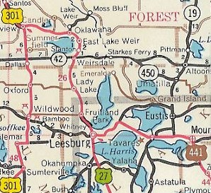
US 441 through Oklawaha
1959 Official
|
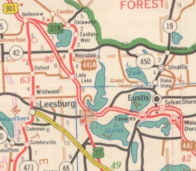
US 441 ALT through Oklawaha
1964 Official
|
US 441 ALT #3: In June 1964 (AASHO), US 441 was given its bypass around the north of Tavares and Mt. Dora. AASHO turned down Florida's request to make the old route US 441 ALT. Now it is CR OLD 441 in Lake County and CR 500A in Orange County.
US 441 ALT #4: In October 1965 (AASHO), US 441 was placed on new alignment from Ocala to Reddick FL. AASHO turned down Florida's request to make the old route via Kendrick, Martin, and Lowell become US 441 ALT. It is now CR 25A. However, it appeared on at least one map... |
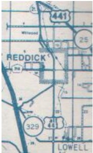
US 441 ALT shown north of Ocala
1981 Ocala map
|
|