<US 441 | Home | US 460 >
US 50 | US 150 | US 250 | US 350 | US 550 | US 650 |
US 450 at US Ends.com
| US 450 usurped | ||||||||
| Previous US 450's: Final ROUTE LOG US 6, US 50: 0 - 0 CO STATE LINE: 106 - 106 |
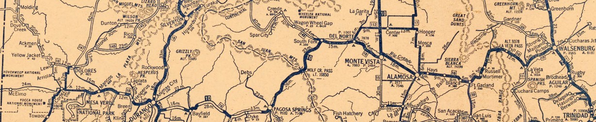
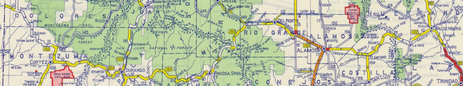
US 450: Appeared in the 1925 original plan, running from US 50 (now W. Valley Rd) Valley City Jct UT via Monticello UT, Cortez CO, and Alamosa CO to end at US 85 (now I-25 Bus) Walsenburg CO.
In Utah, US 450 was a replacement for UT 9
In Colorado, US 450 was an addition to CO 10. The total distance was reported to AASHO as 465 miles.
 1926 Clasons
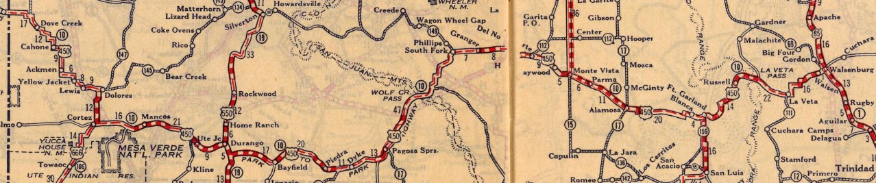 1927 RMcN In May 1930, AASHO and Utah agree that if US 60 were to be extended west from Springfield MO through Kansas and Colorado to Monticello UT, that US 450 would be replace through Colorado and trunated to Monticello with US 60 also ending at Monticello pending completion of the road towars the Grand Canyon and beyond. Note that in a March 1930 discussion with Kansas about US 60 passing through there, AASHO specifically said US 60 would replace US 450 to US 50 as its temporary western ending. Also in May 1930, AASHO approved the extension of US 160 through Colorado to replace US 450 to the Utah State line. This was contingent on proper surfacing of the route in southeastern Colorado and no signage should appear until such time. In July 1930, AASHO detailed the route of US 160 that included an initial posted endpoint at US 54 Meade KS and that once the road was improved in southeastern Colorado, US 160 would replace US 450 to Monticello UT. In 1931 (CDOT), US 450 was rerouted between Monticello UT and Dove Creek CO to use modern US 491's route. The old route used abandoned from Edge of Canyon Rd/CR 335/CR 308/CR 337/Boulder Rd/Boulder Cutoff Rd/CR 332 north/Old Highway Rd which becomes Rd C in Colorado; CO 141 south to US 491. Truthfully the Utah side is guesswork as no map has enough detail of how its stair-stepping ran, but the Utah mileage is about correct for this. In January 1931 (CDOT), US 450 was removed from Ice House Rd/abandoned along RR/Trinchera Ranch Rd/Beekman Rd/CR 25 between Fort Garland and Mortimer. In April 1932, Colorado confirmed with AASHO that US 160 cannot be signed in Colorado until the route is improved in southeastern Colorado. In May 1932 (CDOT), US 450 was removed from CR 5N, CR 27A, CR 27, Pinada View, Prospect Ave, Broadway St between Del Norte and Monte Vista. Also in May 1932, an article appeared in a Walsenburg CO newspaper discussing an extension of US 450 to US 50 at La Junta CO. The article assumed everyone knew what this was about and why hasn't it happened yet. There was no reference to any information from the highway department, however. A delegation from Walsenburg was sent to a statewide meeting to advocate for this extension, per this July 1932 article and a La Junta paper joined the chorus in August 1932 In September 1932, a La Plata County newspaper reported that US 160 had replaced US 450 in its entirety and that signs would be replaced soon. This truncated US 450 east to the UT/CO border. Today, this route is US 491 to Cortez except: 4th St/East St through Dove Creek; Rd 8.9 to just past canal, east on abandoned back to US 491, abandoned just west of US 491 down to Rd 9.9, wavy abandoned route that crosses 491 multiple times, a bit of Rd M, abandoned south across 491 then abandoned parallel to 491 past Rd P, abandoned crossing 491 twice then due south, Rd R through Cahone, Rd 15 south to US 491 near Pleasant View; abandoned south of Pleasant View to just east of Rd 15.5/BB jct, Rd BB east, Rd 18 south through Yellow Jacket, Rd Y back to 491; Rd X east, Rd 20 south, Rd W east through Lewis, Rd 21 south to just short of 491, east on abandoned about 1/2 mile then abandoned south, Rd V east, Rd 22 south, CO 184, CO 145 to eastern Cortez, Dolores Rd. US 450 used US 160 to Walsenburg except: abandoned alighnment across the highway from the Cortez rest area; north Frontage Rd at the Mesa Verde NP interchange; US 160 Bus/Main St/Montezuma St/US 160 Bus through Mancos; starting at MM 60, abandoned alignment north of US 160 winding up to the La Plata County line, then abandoned alignment south of 160 that crosses CR 140 and CR 105 to head east to just under 160 before veering down to near the bluff heading east back to US 160 at MM 67; Cherry Creek Forest Access Rd; CO 140 through Hesperus, CR 125, CR 141 back to US 160 west of Durango; Rosemary Ln; US 550 north/College Dr/E 3rd Ave/E 3rd St/E 8th Ave through Durango, CO 3/Sawmill Rd/CO 3 east out of Durango; CR 233 west of CO 172; lengthy CR 223 east of CO 172; Bayfield Pkwy through Bayfield, then CR 526; abandoned/Gaswell Rd in the MM 108 area; abandoned loop a little past MM 109; Placer Ln and Old Hwy 160 in MM 111 area; CR 168/abandoned bridge/CR 166/CR 175 in the Piedra area; abandoned through Ute and Capote Campgrounds at CO 151; Robbers Roost Rd/abandoned/Stollsteimer Rd/River Run Rd/abandoned/Boyles School Rd well west of Pagosa Springs; Park Ave/Pagosa Ave/abandoned/Village Dr/abandoned/Talisman Dr/Village Dr/abandonded/Winchester Dr/abandoned/Rob Snow Rd west of Pagosa Springs; W Fork Rd/FR 648A/abandoned to horseshoe west of Wolf Creek while ascending towards Wolf Creek Pass; abandoned/Sioux Trail in Gerard; Old Hwy 160 east of Del Norte; Adams Ln/CR 7.4/abandoned/CR 8/Estrella Rd/CR HH/Airport Rd/unnamed road east back to US 160 between Alamosa and Blanca; Weaver Ave/CR HH/CR 18/CR GG5/CO 159 between Blanca and Ft Garland; nearl 4 mile abandoned loop east off 160 east of Fort Garland in the MM 263-266 area; CR VV5/CR 443 over La Veta Pass; abandoned/CR 442/abandoned at the Chain up area; abandoned (from US 160/CR 450 jct) ESE/CR 451/CR 450/Ryus Ave into La Veta; CO 12 out of La Veta; abandoned/CR 502/abandoned through Yucca Campground at Lathrop State Park.
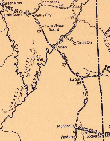
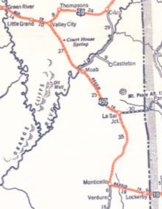
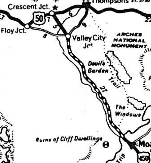
 1934 Official Also in September 1932, a Walsenburg paper reported that the Flagstaff AZ chamber of commerce was rallying support to petition the Arizona Highway Department to request that US 450 be rerouted at Cortez CO to instead head to US 89 Tuba City AZ. There is no evidence that Arizona made this request, though later this corridor was proposed as part of a different corridor. In September 1933 (UDOT), US 50 was rerouted to use a much more direct route from Green River to Thompsons UT. Maps however do not show which former piece of US 50 was being used by US 450 to connect to the new US 50. In April 1934 (UDOT), a direct road from Valley City Jct north to US 50 (now Frontage Rd at I-70/US 191 Exit 182 interchange) was built and US 450 was extended to Crescent Jct.
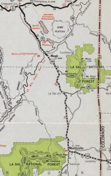
In March 1938, Utah asked AASHO if US 160 had been extended west from Trinity CO to replace US 450 into Utah. AASHO replied that this was an eventuality but that Utah needed to build the road that could get US 160 across Utah and that numberings would remain the same "for years to come." However, Colorado had already signed the extension and Utah's own maps starting in 1934 showed US 450 meeting US 160 at the state line. There is no further correspondence on this, and Utah's 1938 map showed US 450 being replaced by US 160 to Crescent Jct. Today, this is abandoned alignment from I-70's frontage road west of US 191 south about 3.5 miles to US 191; US 191 to UT 313; abandoned just east of 191 becoming Old Highway Moab Cyn, then BLM 261/Moab Canyon Pathway until it reaches Arches National Park where old/new alignments intertwine; at the Arches entrance road, US 450 followed Moab Canyon Pathway (crossing the Colorado River just west of the pathway) to just below UT 128; US 191 to Moab; Centter St/400 East/Mill Creek Dr out of Moab; US 191 to Monticello except abandoned/Yellow Circle Rd/abandoned; some of Bridger Jack Tr; abandoned loop north of UT 46 to the Williams plant; 2 abandoned loops just below UT 46; the lengthy Joe Wilson Rd from roughly Wilson Arch to US 191/Steen Rd jct; abandoned east parallel from north of Needles Overlook Rd south 5 miles; abandoned from Canyon Rd going directly by Sugarloaf Rock to 1.3 miles past UT 211. From Monticello, US 450 followed US 491 to the Colorado line.
| |||||||


Previous: US 441 | Next: US 460
US 50 | US 150 | US 250 | US 350 | US 550 | US 650
US 450 at US Ends.com
Page last modified 11 March 2026