ROUTE LOG
WV STATE LINE: 0 - 0
VA 259: 2.75 - 2.75
VA 37: 11.44 - 14.19
Winchester-Frederick Line: 0.14 - 14.33
US 11 NB, US 522 NB, VA 7: 1.76 - 16.09
US 11 SB, BEGIN US 17: 0.70 - 16.79
I-81 (exit 313): 0.95 - 17.74
Frederick-Winchester Line: 0 - 17.74
US 522 SB: 0.16 - 17.90
Clarke-Frederick Line: 5.43 - 23.33
US 340: 1.67 - 25.00
VA 255: 2.83 - 27.83
Fauquier-Clarke Line: 5.41 - 33.24
US 17 SB: 1.11 - 34.35
Loudoun-Fauquier Line: 5.71 - 40.06
Fauquier-Loudoun Line: 0.60 - 40.66
Loudoun-Fauquier Line: 4.13 - 44.79
US 15: 7.78 - 52.57
Fairfax-Loudoun Line: 9.01 - 61.58
VA 28: 2.06 - 63.64
I-66 (exit 57): 5.57 - 69.21
Fairfax City-Fairfax Line: 0.82 - 70.03
US 29 SB, VA 236: 0.57 - 70.60
VA 123: 0.96 - 71.56
US 29 NB, VA 237 EB: 1.76 - 73.32
VA 237 WB: 0.28 - 73.60
Fairfax-Fairfax City Line: 0.03 - 73.63
I-495 (exit 50): 2.77 - 76.40
VA 7: 3.24 - 79.64
Arlington-Fairfax Line: 1.30 - 80.94
VA 120: 2.03 - 82.97
VA 27: 1.06 - 84.03
I-66 WB (exit 75), GW PKWY: 2.26 - 86.29
WASH DC LINE: 0.20 - 86.49
|
|
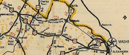
Creation: Appeared in 1925 as an original US Route, running from West Virginia near Gore through Winchester, Middleburg, Fairfax, and Arlington before heading into Washington DC. In this routing, US 50 was added to:
VA 36 from West Virginia to Fairfax.
VA 21 from Fairfax to Washington
Here is a more detailed look at the history of US 50 (from east to west):
US 50 used today's Lee Hwy from the Key Bridge to Fairfax Circle (includes brief VA 309 use of Lee Hwy), then Old Lee Hwy to VA 236 west to Fairfax. Here US 50 headed west on its current route to Middleburg, then used SR 828 loop through Atoka, then crossed over US 50 and crossed Goose Creek near the north end of SR 624. US 50 picked back up today's US 50 through Upperville toward Paris, where it used Federal St through the village.
US 50 then used current US 17-50 up to Ashby Gap but used the SR 601 access roads through the gap. US 50 used today's US 17-50 more or less (some alignments are visible west of SR 601) to the Shenandoah River, where the crossing was slightly south, along River House Ln.
US 50 followed SR 723 through Millwood and Boyce back to US 17-50. US 50 used its current EB routing through Winchester, then SR 803 Round Hill Rd. US 50 followed today's US 50 to West Virginia except: SR 817 Magic Mtn Rd; short SR loop west of Hayfield; Gore Rd through Gore; in between the end of US 50 4-lane and west of SR 703 there is an alignment to the northeast of US 50 with notably twisty curves that is now a long driveway; a short loop at the state line
US 50 original route, avoiding Alexandria
1926 Official
Adjustments: In Feb 1927, at VDOH's urging, AASHO changed US 50 to run with VA 36 to Alexandria (replacing US 211), then with US 1 (now Powhatan St and VA 400) to Washington. The old route from Fairfax to Key Bridge became US 211 and remained VA 21.
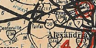
In Dec 1928 (CTB), US 50 was authorized to follow today's US 29 from Fairfax to Washington DC.
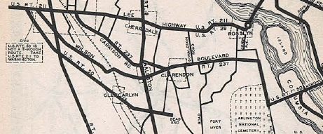
In May 1930 (AASHO), at the suggestion of AASHO, US 50 was moved to Memorial Bridge to go west directly to Fairfax, leaving behind its US 1 Alexandria routing. However, Virginia did note the reason US 50 wasn't running this way already was that there was not an improved road to do this, so it wasn't until today's Arlington Blvd was constructed that this actually occurred.
In July 1935, US 50 was rerouted at Fairfax, now routed on the Fairfax Bypass with US 29 and US 211, then continuing along US 29-211 to Falls Church, then replacing the first VA 236 east to Arlington. US 50 then "ended" at Ft Meyer. There was a gap, then US 50 picked up again at then-VA 237's east end at Arlington National Cemetery and used Memorial Bridge across the Potomac. The route from Fairfax to Alexandria became the current VA 236, while Alexandria to Washington remained part of US 1.
US 50 via Alexandria
1933 Official
|

VA 236 swaps with US 50.
1936 Official
|
In 1936, US 50 was moved onto Millwood Ave through Falls Church instead of following VA 7.
Around 1937, US 50 was made whole again with new primary routing looping around the north end of Ft. Meyer and Arlington Nat'l Cemetery.
US 50 with a dead end and a gap (see note at left edge of scan)
1936 Official
|
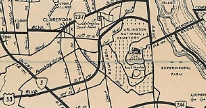
US 50 made whole again.
1938-39 Official
|
In Aug 1937 (CTB), US 50 was rerouted to used today's Arlington Blvd between Fairfax and Seven Corners (new construction). The old route remained part of US 29-211 Lee Hwy, plus today's VA 338
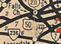
US 50 Falls Church
1938 Official
|
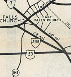
VA 338 in Falls Church
1941-42 Official
|
In May 1943 (CTB), US 50 was placed on new construction bypassing Millwood and Boyce. This left behind SR 723.
In Jan 1957 (CTB), US 50 was removed from the Atoka loop and the loop into Loudoun County across Goose Creek, leaving behind SRs 828/832 (some of this no longer public routing).
Also in Jan 1957, US 50 was given its bypass of Paris, leaving behind SR 759 Federal St.
I cannot pin down when US 50 was given its current one-way splits in downtown Winchester except that it was after Jan 1960 (CTB) which describes US 11 on splits but not US 50 or US 522.
In Feb 1961 (CTB), US 50 was removed from SR 803 Round Hill Rd just west of Winchester.
In Feb 1964 (CTB), US 50 was given its bypass of Gore leaving behind SR 751.
In June 1965 (AASHO), US 50 was moved from Memorial Bridge to the Theodore Roosevelt Bridge into Washington DC. The westbound routing leaving Memorial Bridge is still intact while the eastbound movement has been chopped into discontinuous segments.
It is unclear when US 50 was removed from the curvy alignment west of VA 259.
In 1985 or 1986, US 50 was put on a brief one-way split north of I-81. NB used the original route on Millwood Ave while SB began using Jubal Early Dr and Apple Blossom Dr.
In early 2010, US 50 was signed in Winchester to remove the one-way splits and follow: Boscawen, Braddock, Cork, Cameron, Millwood.
Improvements: US 50 was paved upon designation in 1926 except the westernmost 10 miles in Frederick County.
About 1927, US 50 was paved from the WV line east a few miles.
The remaining gap in US 50 was paved about 1928.
The earliest multilaning of US 50 occurred by 1941, from Fairfax to Washington DC.
Between 1942-47, US 50 was multilaned on the Fairfax Bypass.
In 1960 or 1961, US 50 was multilaned on short segments east of Paris and west of Middleburg
In 1961, US 50 was widened on the Round Hill Rd bypass to Winchester.
In 1962, US 50 was multilaned from SR 614 east to the Round hill Bypass
In 1964, US 50 was widended from Paris west to Ashby Gap
In 1966, US 50 was multilaned from SR 614 west to near Gore.
In 1968, US 50 was widened from VA 28 to I-66.
In 1969, US 50 was widened from VA 28 west to the Loudoun line.
In 1970, US 50 was widened on the Gore bypass
In 1972, US 50 was widened from SR 723 to Winchester
In 1973, US 50 was 4-laned from US 340 to SR 723
In 1974, US 50 was widened from Gore to just west of VA 259.
In 1975, US 50 was widened from Ashby Gap to Shenandoah River; Loudoun-Fairfax Line west to past SR 659; I-66 to US 29.
In 1976, US 50 was was widened from Shenandoah River to US 340
US 50 is limited access from the DC line west to just past VA 27; also from VA 120 west to past George Mason Dr
US 50 is 6-laned from just west of VA 28 to I-66; Eaton Pl (Fairfax) to Fairfax Circle; SR 669 to just east of I-495; just east of VA 7 to Washington DC
Posted: Fully posted; Most cutouts in Winchester were replaced in the early 2010s; at least one set still existed in 2021.
Multiplexes: US 11, US 522 (0.70 mi)
US 17, US 522 (0.95 mi)
US 17 (16.61 mi)
US 29 (2.72 mi)
VA 237 (0.28 mi)
I-66 (0.20 mi)
Legislative names: John S Mosby Highway from Winchester to Fairfax (since 4/1/82); Lee-Jackson Memorial Hwy from Winchester to SR 723 (3/20/22 designation predates US 50); James Madison Hwy from Middleburg to US 15 (since 3/19/28);
Harry Flood Byrd Bridge over Shenandoah River (since 8/15/29)
Other names: Northwestern Pike (w of Winchester); Amherst St/Boscawen St (W Winchester); Braddock St/Gerrard St (EB Winchester); Cameron/Picadilly/Braddock St (WB Winchester); Apple Blossom Dr/Jubal Early Dr/Millwood Av (E Winchester); Millwood Pike (I-81 to SR 723); Washington St (Middleburg); Lee Hwy (Fairfax Byp); Arlington Blvd (US 29 to DC)
Scenic Byway: Surprisingly none
Comment: Arguably the most important non-interstate road in the United States today.
US 50 is the longest US route in Virginia with no Business Routes.
Some ESSO maps in the 30s-40s show a US 50 Byp that used today's GW Pkwy from Memorial Bridge to US 1 into D.C. There are no VDOT maps I have seen that show this.
US 50 uses a 19th century bridge in Aldie; its old routing on SR 723 also has some early 20th century bridges.
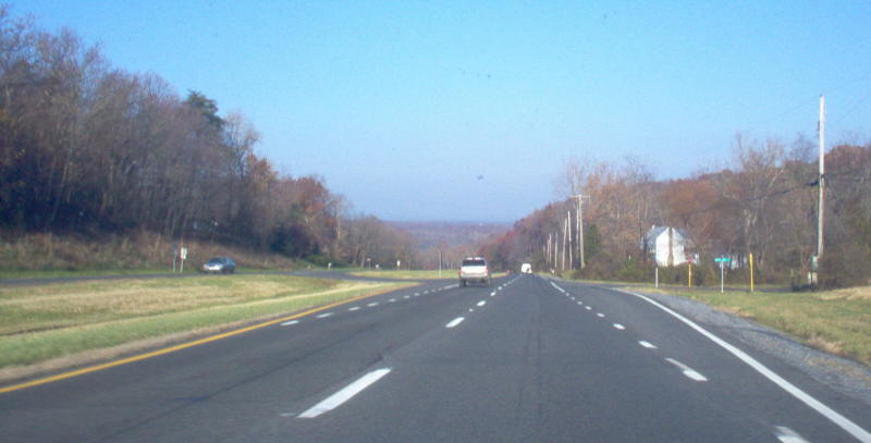
US 50 between US 17 and US 15 runs through some scenic horse country complete with hand stacked stone fences and the like. Traffic calming has become an issue for the communities of Upperville, Middleburg and Aldie. Nobody there wants a bypass (not there is $ for such a thing) so VDOT has been doing other things. For example, in Upperville there are tabletop mesas at intersections and in the US 15 Gilberts Corner area there are 3 roundabouts in place. Speed limits through the villages are a strict 25 mph.
|