<US 522 | Home | US 541 >
US 30 | US 130 | US 230 | US 330 | US 430 | US 630 | US 730 | US 830
US 530 at US Ends.com
| US 530 twice renumbered | |||||
| Previous US 530's: Final ROUTE LOG (530 #1) US 91: 0 - 0 WY STATE LINE: 105 - 105 US 30: 100 - 205 Final ROUTE LOG (530 #2) US 40: 0 - 0 US 530 ALT: 11.3 - 11.3 US 530 ALT: 1.5 - 12.8 US 30S: 11.6 - 24.4 |
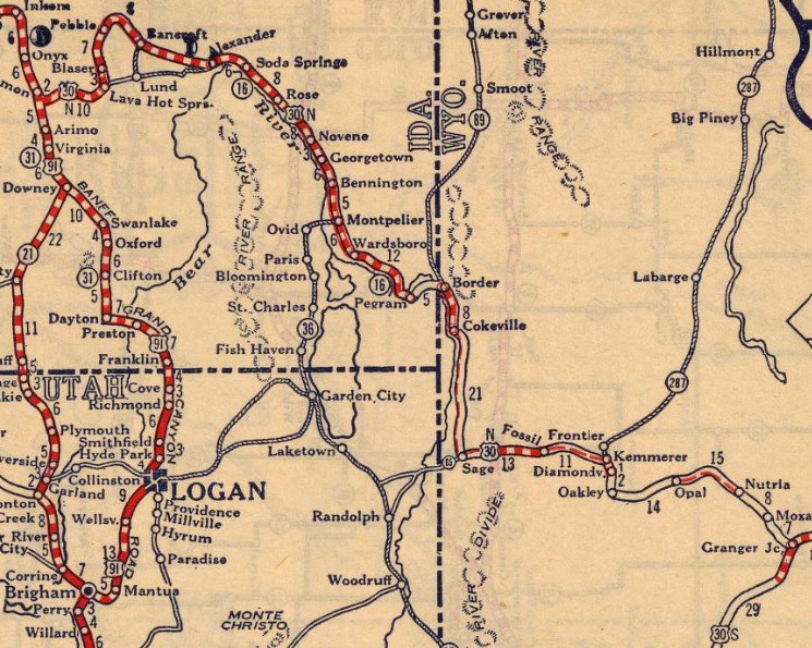
US 530 #1: Appeared in the 1925 proposed US Highway System plan. Ran from US 91 (now I-15 Bus) below McCammon ID to US 30 (now Old Little America Rd) Granger WY. This would've been an addition to ID 30 and a replacement for WY 25.
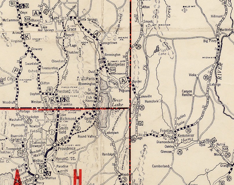
US 530 McCammon ID to Granger WY 1926 Auto Trails In January 1926 (AASHTO), as part of US 30 being rerouted over US 20 to head to Astoria OR, US 530 became part of US 30N. Today this is E Price Rd and E Price Rd Ext, which no longer connects back to Crystal Springs Rd; a bit of US 30; abandoned/Rd N that stays north of Portneuf River to abandoned loop below US 30 to the lengthy E Old Oregon Trail Rd; a bit of US 30; abandoned/Old Oregon Trail to Lava Hot Springs; US 30 through town; Blaser Hwy north through Pebble to Bancroft; Central Rd south past US 30 to Lund; east on Central Rd through Central; ID 34 north to US 30; a couple segments of Hudspeth Cutoff Rd; US 30; abandoned thru golf course/W 220 S; US 30 into Soda Springs; 3rd St/E 490S/abandoned/Gravel Pit Rd east out of Soda Springs; US 30 to north of Montpelier except an east abandoned route near the Bear Lake county line, west abandoned route approaching Georgetown Summit, east abandoned route east of the summit; 8th St/US 89/US 30 through Montpelier; Bench Rd/multiple abandoned loops/Old Hwy 30 (may not be drivable); US 30; abandoned/Peagram Rd through Peagram to the Wyoming line, then north on Border Rd; US 30 into Wyoming At WY 89, US 530 went south on a long abandoned alighment that connects with Magic Mountain Rd; a bit of US 30; abandoned/Nieslanik/abandoned/Snyder Spring Ln/abandoned; US 30 for about 1.5 miles; abandoned loop on east side to Birch Creek Ln; a bit of US 30; Stocktrail Rd/a little Cokeville-Stopher Rd/abandoned; US 30 to Sage; it looks like US 30 has been completely rebuilt on parallel alignments for nearly all of its length; Fossil Butte Rd to just past its rail crossing; unnamed road east that becomes Loma Vista Dr; mostly US 30; abandoned alignment before reaching Conroy Rd/a bit of Sublet Dr/US 30 through Kemmerer; Diamondville Ave/Frontier St/abandoned/E Hillcrest Dr/abandoned routing that crossed Hams Fork ~1.5 miles north of current US 30; abandoned/Kemmerer Landfill Rd/unnamed dirt road/Waterfall Rd/abandonded/Old Hwy 30/abandoned to past Wagon Wheel Dr; US 530 then followed an abandoned alignment that loosely follows current US 30 before cutting south to loosely follow an intermediate older alignment; US 30, then N Front St/bit of Railroad Ave through Opal; US 30; Calhoun Rd/long dirt road/abandoned/"Old US 30" which may not be drivable and runs nearly 15 miles, sometimes as much as 1.25 miles to the east of current US 30, crossing US 30 again to use CR 16 Grainger Rd which no longer crosses the two railroads to connect with Rendezvous Rd into Grainger. US 530 used Spruce St/Grainger Rd out of Granger to end at then-US 30 Old Little America Rd
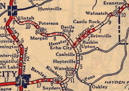
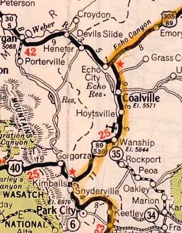
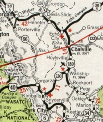
US 530 becomes US 30N 1926 RMcN US 530 #2: Appeared September 1926 (AASHO) as a renumbering of US 30 as a downstream effect of US 30 replacing US 20. Ran from US 40 (now UT 224) Kimball Junction UT to US 30S (now abandoned road) at the original Echo Junction UT, a couple hundred feet south of this railroad underpass. In June 1929 (UDOT), US 530 was relocated eastward and upward between Coalville and Echo Junction to accomodate the new Echo Reservoir. As early as 1933, US 530 was extended northeast over US 30S to meet the modern routing of US 30S (Echo Canyon Rd) at the north end of Echo Dam Rd. In August 1934, AASHO informed Utah that they wanted to replace US 530 with a rerouted US 89 that would replace all of US 30S north of Echo Junction. Utah adamantly opposed this. AASHO returned in December 1934 with a different US 89 plan, from Spanish Fork to Evanston WY, which would still replace US 530. Evidently this went into place as the 1935 Official map shows US 89-530 from Kimball Jct to Echo Jct. In June 1935, US 89 was removed from US 530. About 1936 (bridge date), US 530 was removed from Old Lincoln Hwy east/north of Wanship. The old route became US 530 ALT. By 1938, US 530 was rebuilt in the Spring Creek Jct area. This left behind an abandoned alignment running behind the I-80 View area to the current US 40-189 interchange, then curved east to connect to Silver Gate Dr, following ti to its end, then abandoned routing north to where I-80 crosses Silver Creek. In May 1938 (AASHO), US 530 was renumbered effective January 1, 1939 as UT 530 from Kimball Junction to Wanship (today this is abandoned routing north of Bitner Rd that passed through the Blackhawk neighborhood, Canyon Creek Club, and behind Lincoln Station; I-80's ROW from the EB View Area about 7 miles to where the old railroad stops being in the median; abandoned route along Spring Creek/Blue Sky Rd/Old Lincoln Hwy to Wanship) and renumbered as US 189 from Wanship to Echo Jct (today this is Hoytsville Rd/Main St to Coalville; Echo Dam Rd to Echo Jct)
| ||||
Previous: US 522 | Next: US 541
US 30 | US 130 | US 230 | US 330 | US 430 | US 630 | US 730 | US 830
US 530 at US Ends.com
Page last modified 16 February 2026