<US 789 | Home | mystery corridors >
US 30 | US 130 | US 230 | US 330 | US 430 | US 530 | US 630 | US 730
US 830 at US Ends.com
| US 830 decommissioned | ||||||||||||
| Previous US 830's: Final ROUTE LOG US 101: 0 - 0 I-5 NB, US 99 NB: 62 - 62 I-5 SB, US 99 SB: 40 - 102 US 197 SB: 87 - 189 US 97, US 197 END: 17 - 206 |
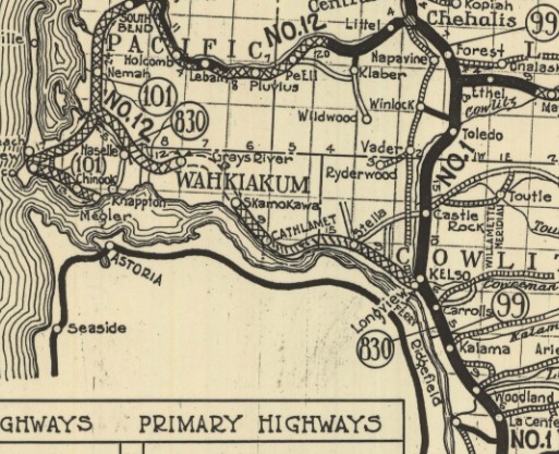
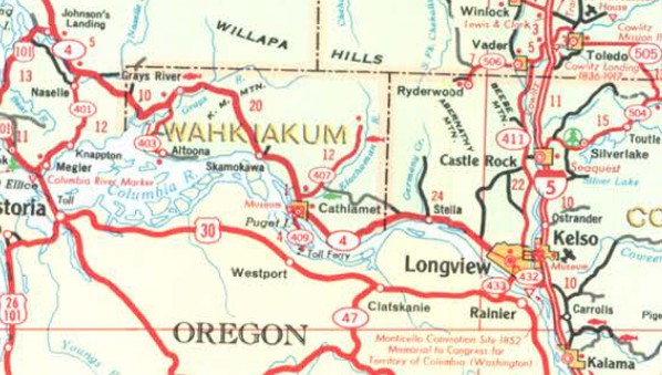
US 830: Created in July 1926 (AASHTO) in the period between the original 1925 preliminary list and the final list in December 1926. US 830 ran from US 101 Johnsons Landing, WA to US 97 Maryhill, WA
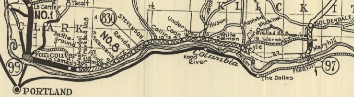
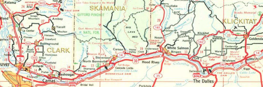
US 830 was an addition to WA 12 from US 101 to Kelso; US 99/WA 1 from Kelso to Vancouver; WA 8 from Vancouver to US 97. The reported beginning mileage to AASHO was 209 miles. This did not include the distance from Lyle to Maryhill on either the proposed routing or the detour to near Goldendale. The mileage was reported as 224 miles in later tables.
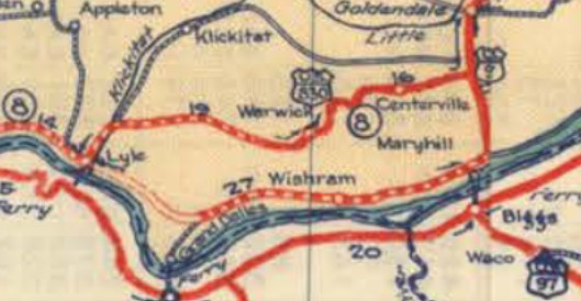
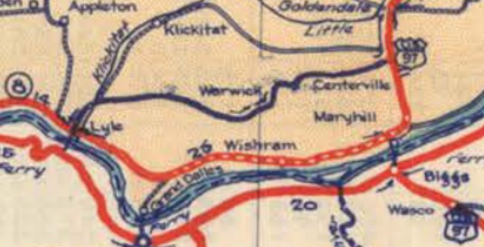
It appears US 830 was removed from Pacific Way west out of Longview/Kelso about 1927. Although official maps as early as 1928 showed a route along the Columbia River from Lyle to Maryhill as US 830, it was not actually usable. US 830 traffic went via Warwick to meet US 97 halfway up to Goldendale. In 1933 (WSDOT), US 830 was rerouted at Lyle to continue following the Columbia River to meet US 97 (now Stonehenge Rd) at Maryhill.
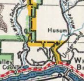
If US 830 ever used NE 3rd Loop east of Camas it stopped doing so by 1934. In 1935 (WSDOT), US 830 was removed from Cook-Underwood Rd (US 830 used Newell Rd; Cooper Ave Spur/Cooper Ave; a bit of Northwest Dam Rd/abandoned routing nearer White Salmon River back to Cook-Underwood Rd about 1/4 mile from WA 14) which went way north to cross the Little White Salmon River. This shortened the route by 8 miles.
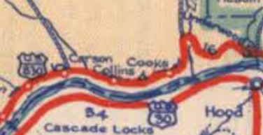
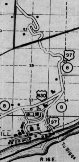
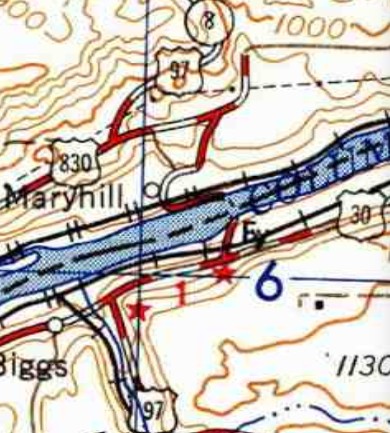
About 1939 (bridge date), US 830 was removed from abandoned bridge/Fairgrounds Rd/E. Valley Rd in Skamokawa. In 1941 (WSDOT), US 99-830 was given a more direct route from north of Woodland south to the Salmon Creek area. The original route used: Old Pacific Hwy/Goerig Rd into Woodland; CC St. across the Lewis River; NW Pacific Hwy to La Center; abandoned across E. Lewis River; NW Pollock Rd; NW Timmen Rd; NE 10th Ave through Pioneer down to NE 164th St; abandoned across I-5; NE Union Rd; NE 20th Ave back to the new alignment which came back in just above NE 129th St. In 1943 (WSDOT), US 830 was removed from E. 5th St, Davis St and E. Evergreen Blvd out to S. Andressen Rd leaving east out of Vancouver and placed on today's WA 14. In 1946 (WSDOT), US 99-830 was removed from Grade St out of Kelso; Old Pacific Hwy/Old US 99; Meeker Dr; 1st St through Kalama; Old Pacific Hwy; Dupont Rd; the southernmost 1/2 mile of Cloverdale Rd About 1949, US 830 east was truncated from Stonehenge Rd in Maryhill to the modern US 97 routing 1.4 miles to the west (US 97 had been using Maryhill Loops Rd to head north to Goldendale). The truncated portion became part of US 97's routing (the eastern half is now part of WA 14, as US 97's routing to the Columbia River moved west off Stonehenge Rd about 1962).
About 1950, US 830 was rebuilt on the east side of KM Mountain, leaving behind a twisty alignment well to the east. Most of this is still accessible dirt road. Also about 1950, US 99-830 was removed from NE 20th Ave below SE 129th St. In September 1952 (WSDOT), US 830 was removed from Allen St across the Cowlitz River in Kelso to instead use Cowlitz Way/4th Ave. In 1954 (WSDOT), US 830 was removed from SE Evergreen Hwy from S. Andressen Rd in Vancouver to SE 164th Ave in Fisher. In 1955 (WSDOT), US 99-830 was put on today's I-5 from WA 14 to Main St in northern Vancouver, leaving behind Washington St/McLoughlin Blvd/Main St. In August 1956 (WSDOT), US 830 was removed from Risk Rd/Foster Rd/Elochoman Valley Rd west of Cathlamet and also bypassed central Cathlamet, leaving behind Una Ave/Butler St/Main St/Columbis St. In 1957 (WSDOT), US 830 was removed from WA 14 EB off-ramp plus the angled piece of SE 164th Ave plus more SE Evergreen Hwy from SE 164th Ave to SE 192nd Ave plus SW 6th Ave to just past SW Alpine Ln near Camas (some parts of 6th were destroyed in this construction). In 1962 (WSDOT), US 99-830 was placed on I-5 from Main St in northern Vancouver to where the I-205 interchange is now in Salmon Creek. In April 1962 (AASHO), WSDOT requested that US 830 from Vancouver to Maryhill be replaced by an extension of US 12. The application did not address US 830 from Vancouver to Johnsons Landing. AASHO denied this request in July 1962. In October 1962 (AASHO), WSDOT retried applying US 12 to replace US 830 exactly as before. AASHO denied this request in December 1962. In March 1963 (AASHO), WSDOT retried applying US 12 to replace US 830 exactly as before. AASHO denied this request in June 1963. In May 1966 (AASHO), WSDOT again requested US 12 be extended through Washington, but this time through the center of the state. However, they offer to decommission US 830 if they approved it. AASHO turned them down in November 1966. In July 1966 (WSDOT), US 830 was placed on a bypass of Camas. This left behind SW 6th Ave; NW 6th Ave; NE Adams St; NE 3rd Ave out of Camas/E St. into Washougal. The eastern end tied into Washougal River Rd then north to E St. In May 1967 (AASHO), WSDOT retried with the US 12 extension in exchange for US 830's decommissioning. This time they requested US 12 extend all the way to US 101. In June 1967 (WSDOT), US 830 was removed from the 6.2-mile Old Hwy 8 and the 1.2-mile Syncline Trail between Bingen and Lyle. In July 1967 (AASHO), US 830 was decommissioned. Johnsons Landing to Kelso became WA 4; I-5/US 99 remained to Vancouver (except Kelso Rd below the I-5/WA 4 interchange); the route to Maryhill became WA 14, which has since been removed from Washougal River Rd/E St/Evergreen Way through Washougal and removed from Evergreen/Cascade through N. Bonneville. Note that US 197 remained on the route the last 17 miles to Maryhill for a time, disappearing from state maps in 1970 and finally officially decommissioned through AASHTO in 2006.
The final length of US 830 was 206 miles. | |||||||||||
Previous: US 789 | Next: mystery corridors
US 30 | US 130 | US 230 | US 330 | US 430 | US 530 | US 630 | US 730
US 830 at US Ends.com
Page last modified 12 December 2025