< VA 21 | Home | VA 23 >
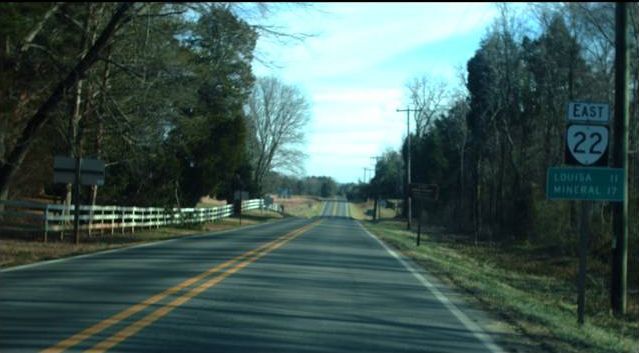
Photo: VA 22 east leaving US 15 Boswells Tavern (photo by Mapmikey 1/23/10)
|
|
|
| ROUTE LOG |
US 250: 0 - 0 VA 231: 5.35 - 5.35 Louisa-Albemarle Line: 3.71 - 9.06 US 15: 3.99 - 13.05 US 33 WB: 6.23 - 19.28 VA 208 WB: 4.92 - 24.20 US 33 EB: 0.40 - 24.60 US 522, VA 208 EB: 5.21 - 29.81
|
Creation: Appeared July 1933 as a renumbering of a segment of original VA 39 from VA 5 (now SR 616 Black Cat Rd) Keswick to US 15/VA 4 Boswell Tavern. his is the 2nd VA 22.
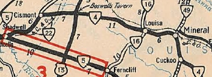
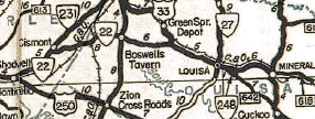
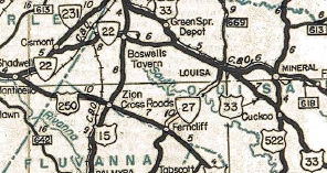
| Adjustments: In March 1934 (CTB), VA 22 west was extended to Shadwell, replacing part of VA 5 which was moved to modern US 250. Even though there was a gap in US 250 from Shadwell to near SR 731, the 1936 Albemarle County map shows VA 22 west of Keswick to Shadwell and teh s/34 CTB clearly removes SR 616 from the primary system. In May 1943 (CTB), VA 22 east was extended over US 33 from Boswells Tavern to US 33's new location at Trevillians. In April 1944 (CTB), VA 22 east was extended with US 33 to Louisa, then replaced more US 33 to its current end in Mineral.
Improvements: Paved since inception; no multilane segments Posted: Fully posted; the last known cutouts were at VA 231 and were removed about 2005. Error US 22 shields have existed at the US 33 split in Louisa CH Multiplexes: US 33 (4.92 mi) US 33, VA 208 (0.40 mi) VA 208 (5.21 mi) Legislative names: The Jefferson Highway (entire route), 3-9-22 designation predates VA 22. Other names: Louisa Rd (west of Louisa CH); Main St (Louisa CH); Davis Hwy (east of Louisa CH) Scenic Byway: US 250 to VA 231 (since 11/19/87) Comment: VA 22 is blown off by I-64, but does have a 4-lane ROW under the bridge. VA 22 runs through some scenic horse country west of VA 231 and through the historic Green Springs district. VA 22 could be truncated to Trevillians, as VA 208 has since overridden VA 22's routing from Louisa CH to Mineral and beyond. | Previous VA 22's:
1932 ROUTE LOG US 311, VA 33: 0 - 0 US 221 SB, VA 205 SB: 5 - 5 US 221 NB, VA 205 NB: 1 - 6 US 11 NB, VA 10 EB: 5 - 11 US 11 SB, VA 10 WB: 2 - 13 VA 207: couple blocks - 13 VA 206: 2 - 15 VA 209 EB: 9 - 24 VA 209 WB: 1 - 25 VA 42: 14 - 39 VA 214: 5 - 44 WV STATE LINE: 13 - 57 GAP IN ROUTE WV STATE LINE: 0 - 57 US 60, VA 14: 8 - 65 |
VA 22 #1: Began in January 1918 as an original state route defined by the general assembly:
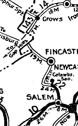
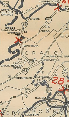
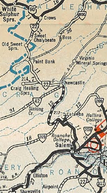
Route 22: Salem, Catawba, New Castle, West Virginia Line
VA 22 thus ran from VA 10 (now US 11) Salem north to the West Virginia line at Peters Mountain
In July 1933, VA 22 was renumbered as VA 119 from US 311 to southern Salem; US 11 through Salem; VA 311 from Salem to Crows. Today, the route VA 22 used is as follows: VA 419, then SR 904 to Starkey. VA 119 then used SR 897 over to US 221. VA 22 duplexed with US 221 north to Old Cave Spring Rd, then northwest on today's McVitty Rd which dances with VA 419 a ways. VA 22 followed McVitty to US 11 (just west of current VA 419) then used East Riverside Dr to curl northwest back around to end at US 11 Colorado Ave. VA 22 followed US 11 to US 460 east to Craig Ave. VA 22 used Craig Ave to leave Salem, then followed VA 311 with these exceptions: SR 1113 Deborah Lane at the I-81 interchange; SR 863 Hanging Rock, SR 864 ascending Catawba Mtn, a visible abandoned segment down the north side of the mountain, and a bit of SR 779; SR 691 south of New Castle; SR 650 south of Crows | ||||||||||||
Previous: VA 21 |
Next: VA 23
Top | Virginia Hwy Index
Home
Page last modified 4 July 2013