< WV 2 | Home | WV 3 ALT | WV 4 >
|
|
|
| ROUTE LOG |
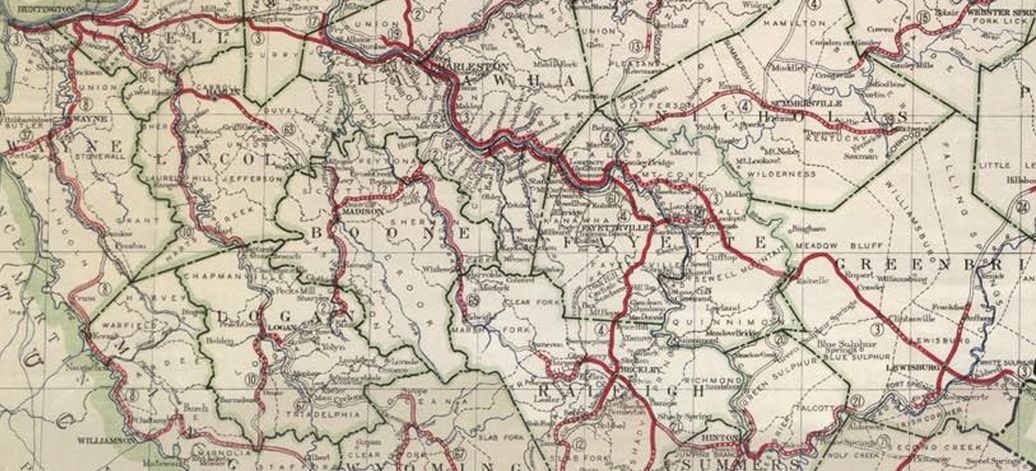
WV 10: 0 - 0 WV 34: 7.5 - 7.5 WV 214: 9.2 - 16.7 Boone-Lincoln Line: 8.7 - 25.4 US 119 NB: 1.7 - 27.1 US 119 SB: 5.1 - 32.2 WV 94: 13.6 - 45.8 WV 3 ALT: 18.9 - 64.7 WV 3 ALT: 0.7 - 65.4 Raleigh-Boone Line: 0.1 - 65.5 WV 99: 25.1 - 90.6 WV 305: 1.4 - 92.0 I-64, I-77 (exit 44): 9.3 - 101.3 WV 16 ALT: 2.0 - 103.3 WV 16: 0.1 - 103.4 WV 3 ALT: 0.1 - 103.5 US 19 NB: 2.3 - 105.8 WV 307: 1.8 - 107.6 WV 307: 2.4 - 110.0 US 19 SB: 1.7 - 111.7 Summers-Raleigh Line: 6.2 - 117.9 WV 20 NB: 8.3 - 126.2 WV 20 SB: 1.0 - 127.2 WV 107: 0.2 - 127.4 WV 12 SB: 5.3 - 132.7 Monroe-Summers Line: 14.5 - 147.2 WV 12 NB: 0.8 - 148.0 US 219 NB: 15.0 - 163.0 US 219 SB: 4.0 - 167.0 WV 311: 19.0 - 186.0
|
Creation: Appeared in 1931 running from WV 10 West Hamlin to WV 81 (now WV 311) Sweet Springs. This was a renumbering of WV 63 from West Hamlin to Danville; addition to WV 2 from Danville to Racine; replaced WV 65 from Racine to Beckley; addition to US 19-21 Beckley to Shady Spring; replaced WV 21 from Shady Spring to Alderson; replaced WV 71 from Alderson to Pickaway; addition to WV 24 (now US 219) Pickaway to Union; replaced WV 85 Union to Sweet Springs. This is the 2nd WV 3.
|
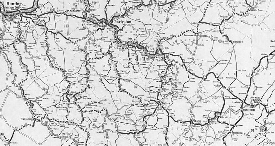
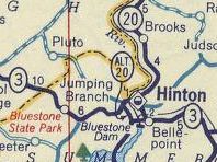
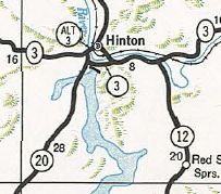
WV 3 West Hamlin to Sweet Springs 1931 Official Adjustments: About 1935 (WVDOT Annual Report), WV 3 was removed from Covington and Piney Creek Rds near Raleigh (south edge of Beckley) In 1938, WVDOH studied requesting replacing all of WV 3 with an unspecified US route number. It is unclear if they formally requested this or not but it obviously did not happen. Between 1938-46, WV 3 was moved from Kanawha St to replace CR 23 Fayette St leaving Beckley to the southeast. Kanawha St became US 19 ALT (now WV 210). About 1957, WV 3 was given its current routing around Hinton replacing WV 20 ALT. The old route through Hinton became WV 3 ALT (now WV 107 and WV 20, except WV 107 has been rerouted off of 1st St over the railroad bridge). It is unclear when the one way pair using Pleasant St and Main St was put into place.
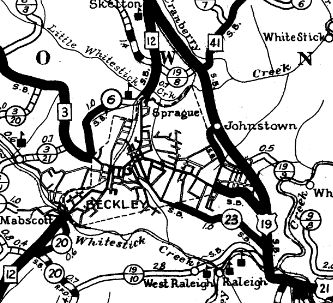
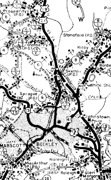
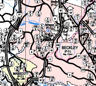
In 1967 (per history of Beckley site), WV 3 was split into one-way splits in Beckley using Neville St EB and Prince St WB. It also appears a one-way split south of Beckley was established using Heber St EB and Fayette St WB. By 1973, WV 3 was placed on its current Beckley routing using 2nd St and a cross-over one way split using 3rd Ave south to WV 16 north to Prince St west for the WV 3 WB routing, while EB uses Nevelle across WV 16 then south on 3rd to 2nd.
About 1990, WV 3 was placed on newly constructed US 119 in Boone County. Surviving segments of old WV 3: CR 119/66 Bradley Rd; CR 119/67 at Van Camp; CR 119/68 Lory Rd and CR 8 Ferrell Hill Rd through Lory Improvements: Upon designation in 1931, WV 3 was paved: West Hamlin to Griffithsville; Racine to Seth; Harper to Union In 1932, WV 3 was paved from Danville to Harper; Woodlands to Moundsville In 1933, WV 3 was paved from Lincoln/Boone line to Danville; Union to Gap Mills. In 1934, WV 3 was paved from Gap Mills to Sweet Springs. Between 1938-41, WV 3 was paved from Griffithsville to Lincoln/Boone Line, completing the paving of WV 3. In 1990, WV 3 was multilaned when moved to the new US 119 construction. Comment: WV 3 is a route that nearly crosses the entire state but only goes through a few places of any size. Remarkably it has been little improved. | Previous WV 3's:
1927 ROUTE LOG Kentucky State Line: 0 - 0 WV 75: 1 - 1 WV 8 SB: 8 - 9 WV 8 NB: couple blocks - 9 WV 10: couple blocks - 9 WV 62: 1 - 10 WV 34: 24 - 34 WV 17: 15 - 49 WV 2 NB: 12 - 61 WV 14: 1 - 62 WV 2 SB: 1 - 63 WV 4 SB: 36 - 99 WV 4 NB: 2 - 101 WV 41: 20 - 121 WV 76: 4 - 125 WV 20: 12 - 137 WV 24: 30 - 167 Virginia State Line: 15 - 182 |
WV 3 #1: An original 1922 state route. Ran from Kenova east through Huntington, Hurricane, St Albans, Charleston, Ansted, Lewisburg, and White Sulphur Springs before heading into Virginia. I have found no evidence so far that any kind of vehicle crossing of the Big Sandy River into Kentucky from Kenova existed before a bridge opened in 1927.
If WV 3 ever used the following from Ona to well south of Milton to Culloden: CR 60/10 Hollow Rd; CR 60/14 Yates Crossing Rd; CR 60/99 Fox Fire Rd; CR 160/53 Maxey Rd; CR 34 Dry Creek Rd; CR 25 Covered Bridge Rd/James River Tpk; CR 25-1 James River Tpk, it stopped doing so by 1923. If WV 3 ever used CR 20 and CR 25 from Rainelle to Clintonville or CR 60/11, I-64 ROW, and CR 40/3 from Alta southeast back to US 60 it stopped doing so by 1925.
WV 3 Huntington to White Sulphur Springs 1923 Official In late 1926, WV 3 was replaced by US 60. Today, WV 3 is approximated by US 60 from the foot of the bridge to Kentucky (the 1927 bridge was slightly north) through Kenova; Adams/18th St W/Washington Ave/4th Ave/Hal Greer Blvd/3rd Ave/28th St E through Huntington; US 60 to Hurricane except: CR 60/1 W. Pea Ridge Rd, CR 60/5 E. Pea Ridge Rd, CR 60/5 Farmdale Rd/Main St through Barboursville, CR 60/27 Trails End Rd (no longer connects with) and CR 60/41 E. Trails End Rd, WV 34 ALT US 60 to Charleston except WV 34 south out of Hurricane, CR 60/20 Henson Rd, CR 60/19 Stewart Rd, CR 60/18 Black Jack Rd, CR 60/16 Stricklin Rd, CR 60/15 Paul Rd, CR 60/14 Mynes Rd, CR 60/13 Hodges Rd, CR 60/12 Mynes Rd, CR 60/11 Courtright Rd, CR 60/35 Cartland Ln, CR 60/34 Austin Dr (4 segments), CR 60/14 Main St to St Albans, Olde Main Plaza/Pennsylvania Ave/Kanawha Terrace through St Albans, CR 60/5 Kanawha Tpk. Patrick St across the Kanawha River; 4th Ave/Central Ave; Virginia St; Capitol St; Kanawha Blvd through Charleston. SR 60/29 Piedmont Rd; CR 60/12 through Dupont City and Belle; CR 60/21 Dupont Rd; US 60 to Ansted except CR 81 and 81/12 Hull Ave in Cedar Grove, CR 60/45 Old Town Rd in London, abandoned CR 60/30, CR 21/15 Michigan Ave through Smithers, CR 60/31 Boomer Loop Rd, CR 60/89 Fallsview West Rd, CR 160/14 Old Turnpike Rd US 60 to Rainelle except: CR 60/33 James River and Kanawha Tpk, CR 160/11 Old US Hwy 60, CR 60/34 Old Victor PO Rd, CR 60/35, CR 60/36 Memory Gardens Rd, CR 60/37, CR 60/38 Fox Rd, CR 60/39, CR 60/40, CR 60/41, CR 60/11, CR 60/10 Miller Ridge Rd, CR 60/50 Lookout Rd, CR 60/13 Spy Rock Loop, CR 160/16 Holcomb Loop US 60 to Virginia except: CR 60/19 McHenny Rd and Church St into Lewisburg; CR 60/17 Caldwell Hill Loop; CR 60/20 Joe Bennett Rd which used I-64's ROW to loop back around to US 60; CR 15/6 Plesaant Valley Rd in White Sulphur Springs; WV 311
|
|||||||||||
Previous: WV 2 |
Next: WV 3 ALT | WV 4
Top | West Virginia Hwy Index
Home
Page last modified 29 July 2022