< US 52 | Home | US 60 ALT | US 60 CONN | US 60E >
|
|
|
|
| ROUTE LOG |
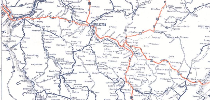
Kentucky State Line: 0 - 0 WV 75: 1.2 - 1.2 Cabell-Wayne Line: 4.4 - 5.6 US 52: 1.0 - 6.6 US 60 ALT: 1.5 - 8.1 WV 527 ALT: 0.5 - 8.6 WV 527: 0.2 - 8.8 WV 10: 0.7 - 9.5 WV 101: 1.8 - 11.3 WV 2, WV 106: 0.3 - 11.6 WV 101: 0.4 - 12.0 I-64 (exit 15): 2.9 - 14.9 WV 10 ALT: 1.6 - 16.5 WV 193: 1.6 - 18.1 Putnam-Cabell Line: 14.3 - 32.4 WV 34 ALT: 0.6 - 33.0 WV 34 NB: 1.3 - 34.3 WV 34 SB: 0.1 - 34.4 Kanawha-Putnam Line: 7.0 - 41.4 WV 817: 2.4 - 43.8 WV 25 SPUR: 1.4 - 45.2 I-64 (exit 54), WV 601: 7.2 - 52.4 WV 61: 2.8 - 55.2 US 60 CONN: 0.8 - 56.0 WV 25: 0.1 - 56.1 US 60 CONN: 0.2 - 56.3 I-64 (exit 58C), US 119: 1.6 - 57.9 WV 114: 2.1 - 60.0 I-64 WB, I-77 NB (exit 97): 2.3 - 62.3 I-64 EB, I-77 SB (exit 96): 1.0 - 63.3 WV 61N: 10.1 - 73.4 WV 6: 12.2 - 85.6 Fayette-Kanawha Line: 0.4 - 86.0 WV 16 NB: 10.6 - 96.6 WV 16 SB: 4.8 - 101.4 US 19: 10.9 - 112.3 WV 41 NB: 7.2 - 119.5 WV 41 SB: 2.5 - 121.7 Greenbrier-Fayette Line: 10.2 - 131.9 WV 20 SB: 0.6 - 132.5 WV 20 NB: 4.4 - 136.9 I-64 (exit 156): 10.1 - 147.0 WV 12: 6.2 - 153.2 US 219: 10.6 - 163.8 WV 63: 3.3 - 167.1 WV 92: 7.2 - 174.3 I-64 WB (exit 181): 1.4 - 175.7 WV 311: 2.2 - 179.9 Virginia State Line: 0.7 - 180.6
|
Creation: Appeared in late 1926 as an original US highway, replacing WV 3 from the Kentucky line at Kenova east through Charleston and Lewisburg before entering Virginia east of White Sulphur Springs. Note this was slated to be US 62 as late as August 1926 (AASHO) after first being US 52 and US 60E was also floated.
|
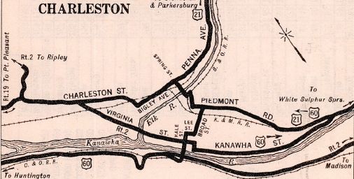
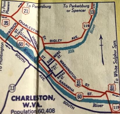
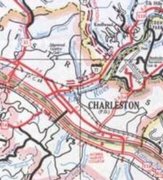
US 60 added to WV 3 Huntington to White Sulphur Springs 1927 Clasons Adjustments: In 1929, US 60 was rerouted in Charleston. Originally, US 60 followed McCorkle to a bit east of the Patrick St bridge, then a road that was covered by existing I-64 and US 119; then headed south on what is now destroyed by the US 119-US 119 SPUR-US 119 CONN setup to cross Ferry Branch, then looped back around north to connect with today's Ferry Rd, then along the Kanawha River to the location of the bridge prior to the South Side Bridge to cross the river. On the Charleston side of the river, US 60 split into directional routes: EB left Hale St at Virginia St (then-WV 2) east to Broad St (now Leon Sullivan Ave) south to Kanawha St east out of the city; WB left Kanawha St at Piedmont Rd (in the vicinity of today's 35th St bridge, as I-77 destroyed some of Piedmont) and followed Piedmont (which was also US 21 in both directions) to Broad St, then south to Lee St west to Hale St south to the Kanawha River Bridge. The new 1929 routing appears to use the current Southside Bridge, the EB went east on Virgini St and south on Broad St to Kanawha St. WB stayed on Kanawha St throughout, then north on Hale St to Virginia St east to the new bridge.
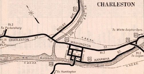
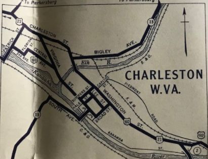
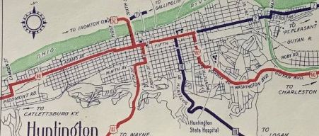
In 1931, US 60 was placed on its current routing through Ona and Milton. The old route used CR 60/15; CR 60/10 Hollow Rd and CR 60/14 Yates Crossing Rd; Foxfire Rd and Maxey Dr; the east-west portion of CR 31/9 Dry Creek Rd and CRs 25 and 25/1 James River Turnpike About 1931, US 60 was removed from the Hale St Bridge (was also WV 13) to enter Charleston and instead used the Patrick St bridge, then headed southeast on 3rd Ave, north on Florida St, east on Central Ave, then east on Virginia St. The 1932 map is vague but I *think* US 60 then used split routing with EB using Virginia/Hale/Lee/Broad/Washington on out of town, while WB used Washington/Summers/Virginia. Also in 1931, US 60 was removed from CR 60/9 McElhenny Rd and Church St heading into Lewisburg. In 1933, US 60 was put on a new routing leaving Huntington and bypassing central Barboursville. The original routing used Main St east of the Wyandotte river in Huntington, then Riverside Dr and the 5th St bridge over the Wyandotte southeast of the city; CR 60/1 Pea Ridge Rd; SR 60/5 E. Pea Ridge Rd/Farmdale Rd/Main St through Barboursville. 3rd Ave/Bridge St east of 20th became an extended WV 5. US 60 now used 20th to Norway Ave About 1937, WV 4 was added to US 60 from Kentucky to Charleston Also about 1937, US 60 was rerouted in Charleston away from central downtown to instead use Patrick to Charleston St to Washington St in both directions. Gen Draft maps from 1933-36 showed US 60 WB already doing this with US 60 EB still using Kanawha.
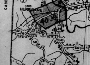
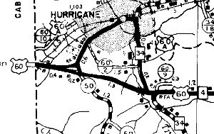
In 1940 (bridge date), US 60/WV 4 was straightened out between Hurricane and St Albans (including bypass of St. Albans), leaving behind: CR 60/20 Henson Rd, CR 60/19 Stewart Rd, CR 60/18 Black Jack Rd, CR 60/16 Stricklin Rd, CR 60/15 Paul Rd, CR 60/14 Mynes Rd, CR 60/13 Hodges Rd, CR 60/12 Mynes Rd, CR 60/11 Courtright Rd, CR 60/35 Cartland Ln, CR 60/34 Austin Dr (4 segments), CR 60/14 Main St to St Albans, Olde Main Plaza/Pennsylvania Ave/Kanawha Terrace through St Albans. By 1942, US 60 was removed from CR 60/29 Piedmont Rd north of Maiden. About 1943, US 60 was moved from 20th/Norway/Washington in Huntington to instead use 29th/8th/31st. About 1943 (bridge date), US 60/WV 4 was given a bypass of Hurricane, leaving behind US 60 ALT (now WV 34 ALT and WV 34).
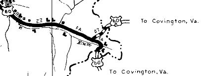
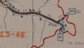
In Oct 1947, US 60 was rerouted at the Virginia line to head east directly to Covington VA, replacing US 60 ALT. The original route south into Virginia became WV 311.
In the late 1940s, US 60 was removed from Piedmont Rd in western Huntington in favor of its current routing along Waverly Rd.
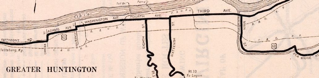
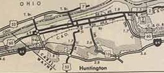
US 60 original Huntington routing 1929 Official
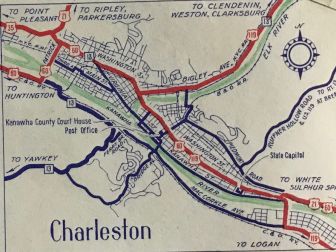
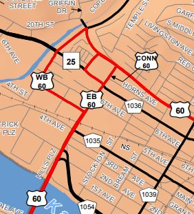
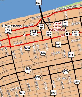
Sometime in the 1950s. US 21-60-119 was placed on one-way splits in Charleston, with WB US 60 remaining on Washington St while EB used Lee St By 1959, US 60/WV 4 was placed on one-way splits in Huntington with EB using 6th St south to 5th Ave east and WB using the original alignment of 4th Ave. About 1959, US 60 was removed from CR 60/12 Dupont Ave between Maiden and Belle. Between 1965-72, US 60 was given its odd splits at its junction with WV 25 (where US 21 and US 35 used to all converge). WB uses Washington/Iowa/5th Ave/Patrick, while EB uses Patrick to 7th Ave west to Rebecca St north to Washington. However, in the field US 60 EB is signed to use Patrick all the way (on paper Patrick between 7th and Washington is US 60 CONN).
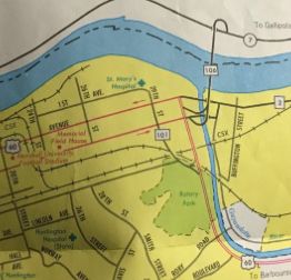
Around 1967, US 60 was given a split routing east of White Sulphur Springs when I-64 came along. EB follows the original route while WB follows I-64 another mile to Exit 181. About 1969 (bridge date), US 60 was removed from CR 60/21 E Dupont Ave from Belle to Diamond By 1970, US 60/WV 4's one-way split in Huntington was continued west to the current US 52 bridge. In 1993 or 1994, US 60 was rerouted at the east end of Huntington, using 31st St. The old route via 26th and 8th Ave became an unsigned WV 101. About 1994, US 60 WB in Huntington was removed from 4th Ave between 1st St and 13th St to instead use Veterans Blvd, 3rd Ave and 1st St. Some of 4th St is now unposted US 60 ALT.
Improvements: Fully paved upon inception By 1942, US 60 was multilaned from St Albans to Maiden Between 1949-56, US 60 was multilaned from Huntington to Barboursville; today's WV 817 to St Albans By 1952, US 60 was multilaned through western Huntington to nearly Twelvepole Creek About 1957, US 60 was multilaned through most of Kenova About 1959, US 60 was multilaned from Maiden to Belle About 1967, US 60 was multilaned when it was converted to being part of I-64 east of White Sulphur Springs About 1969, US 60 was multilaned from Belle to Diamond By 1971, US 60 was multilaned through Milton Between 1997-2003, US 60 was multilaned from Diamond to near Shrewsbury Comment: US 60 is the Midland Trail thrgouh West Virginia. US 60 is not a good alternative for most of I-64 because it is either a slog (Kenova to Charleston) or mountainous (Diamond to Lewisburg). US 60 is blown off by I-64 west of Alta; west of Lewisburg; at Caldwell |
|||||||||||||||||||