< WV 1 | Home | WV 2 ALT | WV 2 SPUR | WV 3 >
|
|
|
| ROUTE LOG |
US 60, WV 106: 0 - 0 WV 193: 5.7 - 5.7 Mason-Cabell Line: 11.4 - 17.1 US 35: 19.7 - 36.8 WV 2 SPUR: 0.7 - 37.5 WV 62 NB: 0.3 - 37.8 WV 62 SB: 2.7 - 40.5 WV 87: 9.9 - 50.4 Jackson-Mason Line: 1.8 - 52.2 WV 62 SB, WV 331: 1.0 - 53.2 WV 62 NB: 3.0 - 56.2 US 33 WB, WV 68: 6.0 - 62.2 I-77 SB (exit 146), US 33 EB: 2.3 - 64.5 EXIT 154 - CR 1: 8.5 - 73.0 Wood-Jackson Line: 2.6 - 75.6 EXIT 161 (NB only) - CR 21: 4.6 - 80.2 EXIT 161 (SB only) - CR 21: 1.4 - 81.6 EXIT 170 - WV 14: 6.9 - 88.5 EXIT 173 - WV 95: 3.2 - 91.7 EXIT 174 - WV 47: 0.7 - 92.4 EXIT 176 - US 50: 2.5 - 94.9 I-77 NB (exit 179), WV 68: 3.6 - 98.5 WV 31 SB: 3.2 - 101.7 WV 31 NB: 0.1 - 101.8 Pleasants-Wood Line: 3.3 - 105.1 WV 807: 9.4 - 114.5 WV 16: 1.0 - 115.5 Tyler-Pleasants Line: 7.0 - 122.5 WV 18 SB: 8.7 - 131.2 WV 18 NB: 0.9 - 132.1 Wetzel-Tyler Line: 4.2 - 136.3 WV 180: 4.2 - 140.5 WV 7 EB: 1.1 - 141.6 WV 7 WB: 1.5 - 143.1 Marshall-Wetzel Line: 5.3 - 148.4 WV 2 ALT: 15.6 - 164.0 WV 2 ALT: 2.3 - 166.3 WV 2 SPUR: 0.9 - 167.2 US 250 SB: 1.3 - 168.5 WV 86: 1.2 - 169.7 Ohio-Marshall Line: 6.3 - 176.0 I-470 (exit 1): 1.3 - 177.3 US 250 NB: 0.7 - 178.0 US 40 WB: 0.8 - 178.8 I-70 (exit 1): 0.1 - 178.9 US 40 EB: 0.2 - 179.1 Brooke-Ohio Line: 8.4 - 187.5 WV 67: 6.8 - 194.3 WV 27, WV 27 SPUR: 0.6 - 194.9 WV 27 ALT: 4.2 - 199.1 WV 2 SPUR: 2.1 - 201.2 US 22 WB: 1.6 - 202.8 US 22 EB: 0.7 - 203.5 Hancock-Brooke Line: 0.2 - 203.7 US 22 ALT: 0.1 - 203.8 US 22 ALT: 0.1 - 203.9 WV 105: 1.8 - 205.7 WV 8: 7.3 - 213.0 US 30: 12.2 - 225.2
|
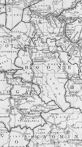
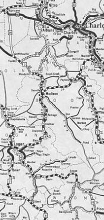
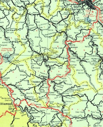
Creation: An original state highway that began in 1922 at WV 10 Logan, then headed northeast through Madison to Charleston, then north through Ripley to Parkersburg, then followed the Ohio River through St. Marys, Moundville, Wheeling, and Weirton before entering Ohio at Chester. This is the only WV 2.
|
Adjustments: In late 1926, US 21 was added to WV 2 from Charleston to Parkersburg.
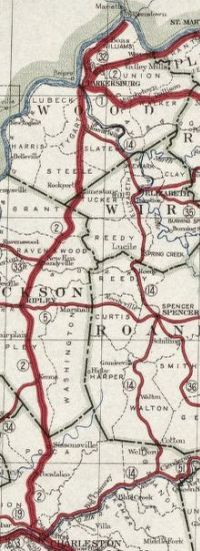
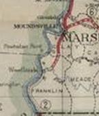
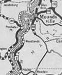
About 1927, WV 2 was placed on its current routing from Woodlands to Moundsville. The original route used today's CR 27 to Grayville, a bit of CR 74, CR 72, CR 2/1, then CR 21 north back to WV 2. At the time of the rerouting, all of the CR 21 portion became WV 88.
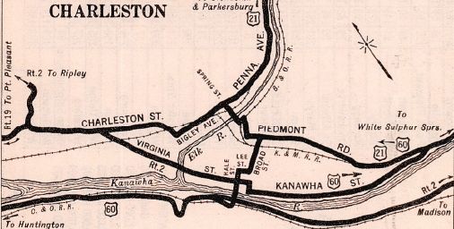
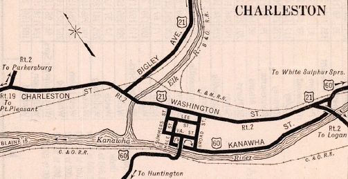
In 1929, WV 2 was rerouted in Charleston. Originally it followed today's WV 61 to the old Hale St bridge then west on Virginia St out of Charleston. Now, it crossed at the 35th St bridge and followed Washington St all the way through.
In 1931, WV 2 was extended south, replacing WV 10 to end at WV 8 (now 0.3 miles north of US 52) near Pie. In 1932, WV 2 was rerouted at its north end to meet US 30 near the Pennsylvania line. The old route became CR 5 into Chester. In 1935, WV 2 south was truncated to US 21 Parkersburg, leaving behind US 21 to Charleston (this is CR 21 to Mineral Wells except: CR 21/24 Falcon Dr between Charleston and Guthrie; CR 21/38 Whittington Rd; CR 21/37 Whittington Rd N; CR 21/18 Margaret Ln; a bit of CR 24 Wallace, CR 24/1 Old Tupper Creek Rd, CR 24/2 Arney Dr (no longer connects to), CR 21/30 Honeywell Dr; CR 21/39 Rena Dr; CR 21/29 Stalite Rd near Pocatalico; CR 21/21 Old Mill Rd in Sissonville; Faber Ln and abandoned routing plus a bit of Spindle Ln, abandoned routing and Faber Ln south of WV 34; CR 21/23 Cemetery Rd and (no longer connects with) CR 25 Cedar Lakes Dr, plus Charleston Dr from Fair Plain to Ripley; disconnected Leaf Ln and Wet Water Ln around the CR 56 junction area; CR 21/52 Delta Rd in Sandyville; a bit of WV 14 and abandoned routing back to CR 21; WV 14 to Parkersburg except: CR 14/44 Pike St and a little Alpine St south of Parkersburg; WV 14 ALT) and US 119 from Charleston to US 52 near Pie (now WV 61 to Marmet; WV 94 to Racine; WV 3 and a bit of US 119 to Danville; WV 85 to Madison; WV 17 and WV 10 to Logan; then WV 44 to US 52 except CR 119/26 Riverview Ave/Water St in Mt Gay and 2nd Ave/WV 10/Main St through Logan).
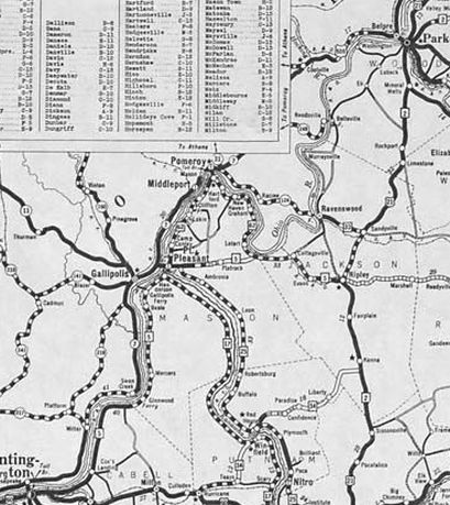
In 1936, WV 2 south was extended southwest with US 21 (now WV 14) out of Parkersburg, then southwest as new primary routing, replacing CR 9/1 and CR 9 in Wood County; CR 2 in Jackson County to Ravenswood. After a brief overlay with WV 33, WV 2 replaced WV 62 through Mt Alto into Mason County, then replaced CR 18 to Chestnut before replacing WV 5 southwest through Point Pleasant and ending at US 60/WV 4 (now WV 101) Huntington.
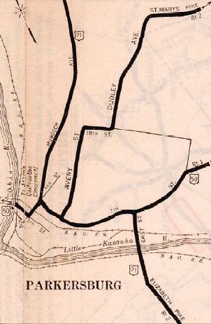
It appears that between 1934-37, WV 2 was rerouted in South Wheeling from Chapline/Water and 39th to instead use Chapline/33rd to reach Jacob. In 1936 or 1937, WV 2 was rerouted from Parkersburg past Waverly, leaving behind Market St/16th St/Dudley Ave/36th St in Parkersburg; CR 16 Old St Mary's Pike through Borman and Valley Mills; SR 16/7 through Bethel Chapel; CR 21/6 and CR 1 through Waverly
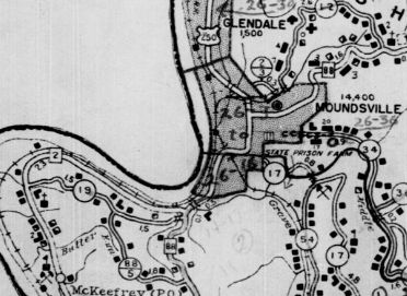
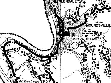
By 1938, WV 2 was put on a one way pair in Wheeling. SB used the original route - Main St. NB uses 16th/Market/7th. A second one way pair used Jacob/33rd NB and Eoff/39th SB. Between 1941-46, WV 2 was rerouted between Belleville and Sherman to use current WV 68. This was mostly new alignment but did usurp some CR 4. The old route became CR 9, CR 25/13, and CR 25. In 1943 (bridge date), WV 2 was given its routing through western Moundsville. The old route used Jefferson Ave (became US 250 ALT into downtown and WV 88 south of downtown) and 7th St back to Lafayette (remained WV 88 for a time).
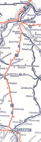
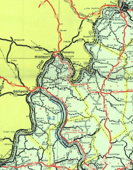
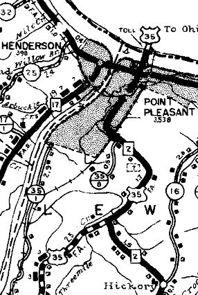
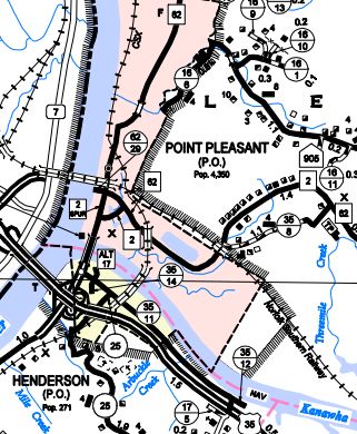
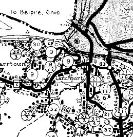
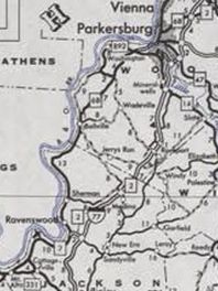
Between 1938-46, WV 2 was moved from Main St to County Rd in Weirton. In 1947 (bridge date), WV 2 was removed from 8th Ave/Lubeck Ave/Camden Ave through Lanchport and instead used newly constructed route (Dupont Rd) due east to US 21 (now WV 14) further south. In 1954 (bridge date), WV 2 was removed from CR 2/2 northeast of Belleville and placed on current WV 68. Also in 1954 (bridge date), WV 2 was placed on today's WV 68 through Ravenswood. Previously it used Sand St, Henry St, Ashton St plus CR 68/2 Old WV 2 south of Sandy Creek. Also in 1954, WV 2 was straightened out in Ripley Landing. Some of Ripley Landing Rd was the old alignment. In 1955 (bridge date), WV 2 was removed from Eli Locust/Belleville/Wadesville Rd/Woodyard Run Rd a little south of today's WV 892. Also in the mid 1950s time frame, WV 2 was placed on new alignment east of the railroad from CR 25 to CR 11 at Belleville/Humphries. Also in the mid 1950s time frame, WV 2 was removed from CR 2/20 west of Ravenswood as an upgrade to CR 62/3. About 1957, WV 2 was placed on today's WV 68 through Lubeck, leaving behind CR 9/7 Between 1957-59, WV 2 was removed from CR 2/10 in Lesage. About 1960, WV 2 was given its current routing through Wellsburg. The old route used Commerce St, 11th St, Charles St, 27th St, and Pleasant Ave. In 1964 (bridge date), WV 2 was removed from CR 2/7 Marshall St in McMechen and Benwood. In the mid 1960s, WV 2 was moved to 3rd St in Point Pleasant as new construction between 6th and Viand. 6th remains part of WV 62 and Viand between 3rd and 6th is WV 2 SPUR.
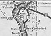
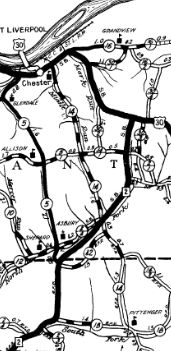
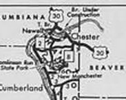
Between 1965-70, WV 2 was rerouted at its north end to continue following the Ohio River to Chester, replacing WV 66 and ending at US 30 which was using 1st St then. The old path to US 30 east of Chester became WV 8.
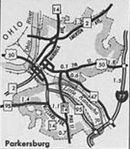
In the mid-1970s, WV 2 was given its route through St Marys. The old route used 2nd St and Clay St. In 1972, WV 2 was rerouted south out of Parkersburg, using today's WV 68 leaving behind WV 14 Division St and WV 95 Dupont Rd.
Between 1971-77, WV 2 was removed from CR 2/12, 2/13, and 2/14 in Green Bottom. In 1974 or 1975, WV 2 was rerouted onto newly constructed alignment in South Wheeling, then used 33rd St west back to Jacob. This was a replacement for WV 2 ALT. Between 1974-77, WV 2 was removed from CR 2/8, 2/9, and 2/10 Frontage Rd in McKefrey. In 1977, WV 2 was extended north replacing US 30 from 1st St out to the newly constructed US 30 expressway and Ohio River bridge. Between 1978-80, WV 2 was rerouted between Ravenswood and Parkersburg by replacing WV 56 east, then joing I-77 north past Parkersburg to where WV 2 crossed it before. The old routing became WV 68.
About 1981, WV 2 was placed on more new freeway in Wheeling and then used Eoff/16th (NB) and 16th/Chapline (SB) to connect to the Main/Market pair. In 1993 or 1994, WV 2 south was truncated to its current US 60 endpoint, as US 60 was rerouted to use what had been the last few blocks of WV 2. Improvements: By 1923, WV 2 was paved from Marmet to Sissonville; Fairplain to Ripley; Mineral Wells to Parkersburg; south of Moundsville to Chester. In 1924, WV 2 was paved Belmont to Sistersville; New Martinsville to Proctor. In 1925, WV 2 was paved from Logan to Boone County Line In 1926 or 1927, WV 2 was paved Logan/Boone Line to Marmet; Sissonville to Fairplain; Ripley to Mineral Wells. In 1931, WV 2 was paved Logan to Switzer when extended south to WV 8; also from Proctor to Woodlands In 1932, WV 2 was paved from Waverly to Belmont; Woodlands to Moundsville In 1933, WV 2 was paved from US 52 to Switzer In 1934, WV 2 was paved from Parkersburg to Waverly, completing the paving of WV 2. The 1936 redirect to Huntington was paved in Cabell County; Gallipolis Ferry to east of Point Pleasant; Ravenswood to Sherman; a few miles west of Parkersburg. By 1941, WV 2 was paved from Gallipolis Ferry south to Gallipolis Dam. By 1946, WV 2 was paved from Cabell/Mason Line to Gallipolis Dam. Pt Pleasant to Ravenswood and Sherman to near Parkersburg weren't paved until after 1946. By 1976, WV 2 was multilaned WV 95 to Parkersburg; south of Moundsville; McMechen to below Wheeling; Wellsburg north a couple miles Between 1978-80, WV 2 was multilaned from Ravenswood to north of Parkersburg mostly by virtue of addition to I-77. In 1981, WV 2 was multilaned through Wheeling BY 1986, WV 2 was multilaned from Moundsville to McMechen. In 1993 or 1994, WV 2 was multilaned on its duplex with the new US 22 freeway in Weirton. Comment: WV 2 has a posted TRUCK route northbound in Huntington using 5th Ave to Main St, back to at least 1973. There is a poorly posted WV 2 EMERGENCY route from Proctor to Moundsville that follows the old WV 89 east, then CR 21 north to meet WV 2 at the eastern end of WV 2 ALT. Given the very limited posting (may only be 1 shield left?) this probably doesn't officially exist. Posts on road forums suggest this is a terrible through route, especially for a truck. WV 2 is a major corridor, expecially north of Parkersburg as it follows the Ohio River all the way to Chester. There are plans to have this multilaned everywhere in that stretch though it may be many years before this is accomplished. | |||||||||||||||||||||||||||||

Previous: WV 1 |
Next: WV 2 ALT |WV 2 SPUR | WV 3
Top | West Virginia Hwy Index
Home
Page last modified 16 July 2022