< WV 3 | Home | WV 4 ALT | WV 5 >
|
|
|
| ROUTE LOG |
US 119: 0 - 0 Clay-Kanawha Line: 6.6 - 6.6 Kanawha-Clay Line: 0.7 - 7.3 Clay-Kanawha Line: 2.6 - 9.9 WV 36: 8.3 - 18.2 WV 16 SB: 2.5 - 20.7 WV 16 NB: 11.2 - 31.9 Braxton-Clay Line: 9.3 - 41.2 I-79 (exit 51): 7.6 - 48.8 I-79 (exit 62), US 19: 15.6 - 64.4 WV 15: 5.1 - 69.5 US 19 SB: 1.1 - 70.6 WV 5: 5.0 - 75.6 Lewis-Braxton Line: 12.9 - 88.5 US 19 NB: 3.2 - 91.7 WV 20: 7.4 - 99.1
|
Creation: Appeared about 1937 running from the Kentucky State Line at Kenova to the Virginia State Line near Capon Springs. This was an addition to US 60 from Kentucky to Charleston; a renumbering of WV 13 from Charleston to Sutton; addition to US 19 from Sutton to Ireland; added to WV 5 #2 from Ireland to Rock Cave; addition to WV 20 Rock Cave to Buckannon; addition to new US 33 (which at the same time replaced WV 5 #1) from Buckannon to Seneca Rocks; addition to WV 28 from Seneca Rocks to Romney; addition to US 50 Romney to Virginia. This is the 2nd WV 4.
|
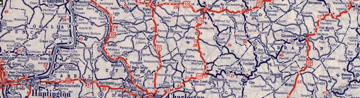
WV 4 from Kentucky through Huntington, Charleston and Sutton 1939 Rand McN
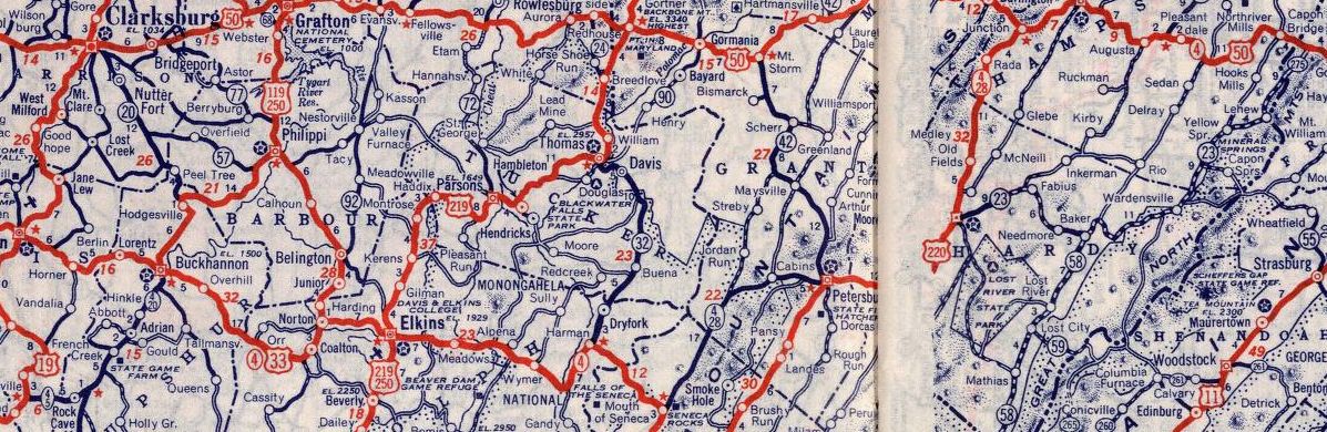
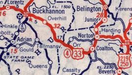
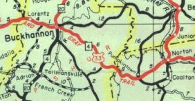
WV 4 continues through Buckannon, Elkins, and Romney to Virginia 1939 Rand McN Adjustments: In 1940 (bridge date), it along with US 60 was straightened out between Hurricane and St Albans (including bypass of St. Albans), leaving behind: CR 60/20 Henson Rd, CR 60/19 Stewart Rd, CR 60/18 Black Jack Rd, CR 60/16 Stricklin Rd, CR 60/15 Paul Rd, CR 60/14 Mynes Rd, CR 60/13 Hodges Rd, CR 60/12 Mynes Rd, CR 60/11 Courtright Rd, CR 60/35 Cartland Ln, CR 60/34 Austin Dr (4 segments), CR 60/14 Main St to St Albans, Olde Main Plaza/Pennsylvania Ave/Kanawha Terrace through St Albans. In 1942, US 33/WV 4 was rerouted from Pumpkintown to Norton to avoid Coalton (now Womelsdorf), leaving behind CR 53.
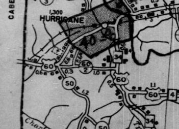
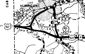
About 1943 (bridge date), US 60/WV 4 was given a bypass of Hurricane, leaving behind US 60 ALT (now WV 34 ALT and WV 34).
Between 1938-46, WV 4-28 swapped routings with CR 28/1 north of Seneca Rocks
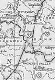
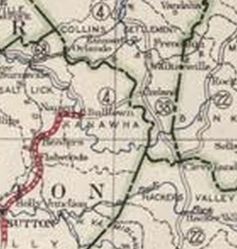
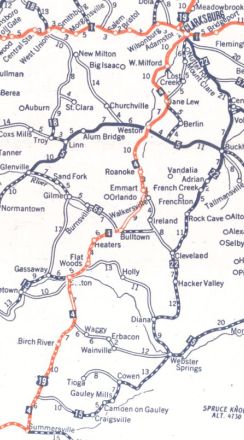
In 1955 (bridge date), US 33/WV 4 was given a newly constructed alignment around Harman, leaving behind CR 32/5 Main St and CR 33/16 Mott St. In 1958 (bridge date), US 220/WV 4-28 was removed from CR 220/8 and CR 2 from Old Fields northward. By 1959, US 60/WV 4 was placed on one-way splits in Huntington with EB using 6th St south to 5th Ave east and WB using the original alignment. In 1960 (bridge date), WV 4-20 was removed from CR 4/15 Hoovertown Rd and CR 20/29 Mulberry Ridge Rd in French Creek. Between 1950-66, WV 4-28 was removed from CR 28/9 Corners Rd at Cabins and CR 28/10 Redman Rd outside Petersburg By 1970, US 60/WV 4's one-way split in Huntington was continued west to the current US 52 bridge. About 1972, WV 4 was truncated on both ends to its current endpoints at US 119 and WV 20. Kentucky to Charleston remains US 60 (except it used today's WV 101); Charleston to Clendenin remains US 119; Rock Cave to Buckannon remains WV 20; Buckannon to Seneca Rocks used CR 151, CR 151/4, WV 92, US 33, CR 33/8, US 33; Seneca Rocks to Romney used WV 28; Romney to Virginia used US 50. In 1978, US 19/WV 4 was rerouted onto newly constructed alignment from Bulltown to Falls Mill to accommodate Burnsville Lake. The old route followed the Little Kanawha River much more closely. Surviving pieces are the access road to the Picnic Area at Bulltown and the old road from the Falls Mill side to the south dip in the river. Improvements: Upon designation, WV 4 was fully paved throughout. In the early 1940s, WV 4 was multilaned with US 60 in South Charleston. By 1956, WV 4 was multilaned with US 60 from Huntington to Barboursville; WV 17 (now WV 817) St Albans to S. Charleston WV 4 has no multilane segments today. Comment: WV 4's initial routing is a mystery. Why did they attach it to so many other routes a decade after removing all US-state route overlays? WV 4 was 353 miles long at one point, making it the longest route West Virginia ever had. With the completion of I-79, current WV 4's usefulness as a through route was seriously reduced. | Previous WV 4's:
1927 ROUTE LOG Virginia State Line: 0 - 0 WV 8 NB: 1 - 1 WV 8 SB: 4 - 5 WV 67: 4 - 9 WV 20, WV 24: 4 - 13 WV 21: 31 - 44 WV 12, WV 65: 8 - 52 WV 41: 25 - 77 WV 61: 15 - 92 WV 3 WB: 1 - 93 WV 3 EB: 2 - 95 WV 13: 5 - 100 WV 39, WV 76: 24 - 124 WV 15: 6 - 130 WV 13: 24 - 154 WV 68: 15 - 169 WV 38: 9 - 178 WV 5: 13 - 191 WV 1 EB: 27 - 218 WV 1 WB: 2 - 220 WV 6 SB: 24 - 264 WV 6 NB: 1 - 265 WV 73: 1 - 266 WV 7 WB: 20 - 286 WV 7 EB, WV 73: 1 - 269 Pennsylvania State Line: 7 - 276 |
WV 4 #1: An original 1922 state route. Ran from the Virginia State Line at Bluefield VA heading through Bluefield WV, Princeton, Beckley, Fayetteville, Summersville, Sutton, Weston, Clarksburg, Fairmont, and Morganton before heading into Pennsylvania headed for Uniontown.
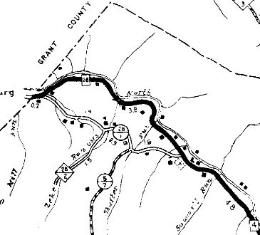
If WV 4 ever used CR 19/2 Broadway Ave and CR 19/1 Nickelville Rd between Mt. Hope and Fayetteville, it appears to have stopped doing so by 1923. It is unclear if WV 4 ever used CR 21/4 Kanawha Tpk and CR 16/10 Rock Camp Rd north of Fayetteville. In 1923 (WVDOT Annual Report), WV 4 was rerouted at Bulltown in Braxton County to head east to Ireland as new primary routing, then replaced WV 38 north to Walkersville where it reconnected with existing WV 4. The old route used today's CR 19/12, CR 19/14, CR 19/9, CR 4/11, CR 4/14, and CR 4/13 in Braxton County; CR 45/4 and a little CR 46 in Lewis County, then several miles of abandoned road to Walkersville.
In late 1926, WV 4 was replaced by US 19 from Virginia to Westover and US 119 from Westover through Morgantown into Pennsylvania.
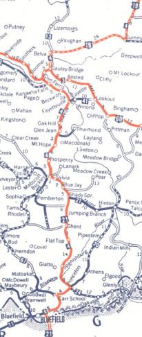
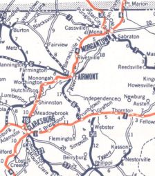
Today, WV 4 is approximated by US 19 through Bluefield; CR 25 Old Princeton Rd out of Bluefield; a bit of US 19-460; CR 25 Mercer Mall Rd to Edison; WV 123; CR 19/33 Maple Acres Rd to Glenwood; Glenwood/Green Valley/Old Bluefield Rds CR 19/29 from Glenwood to Princeton. US 19 to Beckley except CR 19/31 at Camp Creek; from CR 2 to CR 1 in Mercer County the old highway was straightened out due to the construction of the West Virginia Turnpike - some of the abandoned pieces are east of the turnpike; CR 119/6 Sheloh Cir and CR 119/2 Madoc Cir in Cool Ridge; CR 19/19 Cherry Creek Cir and CR 119/8 Lamar Cir in Cherry Creek; CR 19/17 Marshall Cir and CR 19/40 Leenwood Ln at Shady Spring; CR 19/28 Ransom Dr; CR 19/14 Old US 19; CR 119/20 Little Vine Dr; Covington and Piney Creek Rds near Raleigh; WV 210 WV 16 from Beckley to Belva except: CR 21/4 Old US 19 in Skelton; CR 19/5 and CR 4 Prosperity Rd through Prosperity; CR 16/68 Bradley School Rd; CR 19/1 Maple Ln (no longer connects to), CR 1/25, CR 19/43 Sherwood Rd, CR 21/8 Sherwood Heights Rd; Broad St/Michigan Ave/WV 211 Main St through Mt. Hope; CR 19/12 Hilltop Loop at Hilltop; CR 16/13 Market Loop; CR 16/52 Old C F and W Tpk in Oak Hill; WV 16 to Beckwith; CR 13 to Kanawha Falls; US 60 to Gauley Bridge; WV 16 to Belva WV 39 from Belva to Summersville; WV 41 out of Summersville; US 19; CR 43/2, CR 43/1 Old US 19/Willow Tree Ln to Muddlety; the lengthy CR 19/41 through Hookersville and beyon Birch River; about a mile of US 19; lenghty CR 19/40 through Bays, Little Birch, and Tesla to Sutton; current WV 4 to Flatwoods US 19 to Fairmont except: access road to the Picnic Area at Bulltown and the old road from the Falls Mill side to the south dip in the river; abandoned underwater routing from roughly CR 19/14 to the Stonewall Jackson Lake bridge; State Park Rd north along the W. Fork River to Carrion Run then west as abandoned routing to meet US 19 just south of I-79 Exit 91; about 2 miles of I-79 SB ROW; CR 19/37 Wayside Dr.; CR 19/3 Riverside Dr and CR 19/5 Homewood Rd in Homewood; River Rd in Clarksburg; Hood St in Shinnston US 19 to Morgantown except Colasessano Dr (brick pavement!) no longer crosses Buffalo Creek to Old Pennsylvania Ave north of Fairmont US 119 to the Pennsyvania line.
|
|||||||||||||||||
Previous: WV 3 |
Next: WV 4 ALT | WV 4
Top | West Virginia Hwy Index
Home
Page last modified 28 October 2017