|
From:
  Salem, VA
To:

 Salem, VA
Total Length: 3.1 miles
|
|
|
|
|
ROUTE LOG
US 11, US 11 ALT Begin, US 460: 0 - 0
US 11: 1.1 - 1.1
VA 419 SB: 1.4 - 2.5
US 11 ALT NB, US 460, VA 419 NB: 0.6 - 3.1
|
|
Creation: Appeared in December 1946 (AASHO) as a bypass around the downtown Salem VA area. This was a renumbering of VA 117-Y. This is the 1st US 460 ALT
Adjustments: By 1958, US 460 ALT was removed from Lynchburg Turnpike and Schrader St in the Mason Creek area to instead use Texas St.
Between 1997-2002, US 460 ALT EB was routed back onto Lynchburg Turnpike to connect with VA 419 and the ability to turn left from Texas St to VA 419 NB was eliminated.
Comments: US 460 ALT exists to give trucks a routing away from central Salem. It has speed limits no different than mainline US 460.
Uses 4th St/Roanoke Blvd/Texas St; concurrent with US 11 ALT for its entire run.
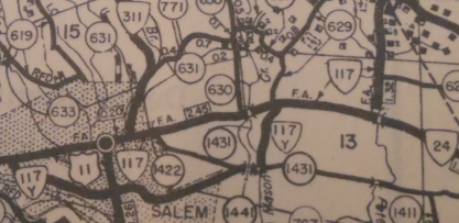
VA 117-Y in Salem
1946 Roanoke County
|
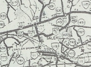
US 460 ALT in Salem
1958 Roanoke County
|
|
|
|
From:

   Bowers Hill, VA
To:
 Norfolk, VA
Total Length: 9.7 miles
|
|
|
|
|
ROUTE LOG
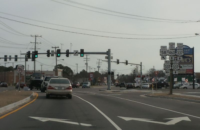
I-664 (Exit 13), US 13, US 58 WB, US 460: 0 - 0
VA 191: 0.5 - 0.5
VA 239: 3.5 - 4.0
US 58 EB, VA 337 WB: 0.3 - 4.3
VA 337 ALT: 0.1 - 4.4
I-264 WB (Exit 4), VA 337 EB: 0.3 - 4.7
US 17: 0.9 - 5.6
VA 164: 0.5 - 6.1
VA 141: 1.1 - 7.2
I-464 (Exit 6), VA 337 WB: 1.2 - 8.4
I-264 EB (Exit 9), VA 337 EB: 0.6 - 9.0
US 460, VA 337: 0.7 - 9.7
|
|
Creation: US 460 ALT appeared November 1952 (CTB Minutes). It
ran from US 13-58-460 Bowers Hill along US 58 to Portsmouth, then east
along Portsmouth Blvd to Norfolk Naval Shipyard, then north along 7th
St/Washington Ave. It turned east at today's I-264 to use the Downtown
Tunnel and the Berkley Bridge. In Norfolk, there was a simple trumpet
interchange at City Hall Ave. US 460 ALT cut west on City Hall, then
used one-way splits of Bank St (EB) and Monticello Ave (WB), ending at
US 460 Brambleton Ave. This is the 2nd US 460 ALT.
Adjustments: Sometime after 1963, US 460 ALT EB in downtown
Norfolk was removed from Bank St and put on St. Paul's Blvd. My guess
is that it was moved as part of building the Norfolk Scope which opened
in 1971.
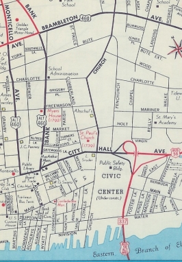
US 460 ALT initial downtown routing
1963 Gen Draft
|
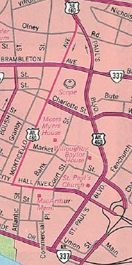
US 460 ALT current downtown routing
1989 Official
|
US 460 ALT was moved onto I-264 from Portsmouth Blvd. through Portsmouth in March 1968 (CTB). Portsmouth Blvd remained part of VA 337 while the remainder is city streets.
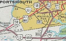
US 460 ALT initial Portsmouth routing
1961 Official
|
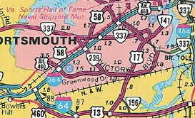
US 460 ALT current Portsmouth routing
1989 Official
|
Comments: In 1993 there was 1 shield on
Monticello Ave at City Hall Ave but appears to be gone now. By February
2013, a new shield was installed on Brambleton Ave at St. Paul's Blvd. Now US 460 ALT is no longer posted eastbound past the title photo on this page.
US 460 ALT is much more direct (4-plus miles shorter) from Bowers Hill to Norfolk than mainline US 460, but has really also been obsolete since I-264 was completed..
|
|
|
From:
   
 Fords Branch, KY
To:
  Grundy, VA
Total Length: 36.1 miles
|
|
|
|
|
ROUTE LOG
US 23, US 119, US 460, KY 80 WB: 0 - 0
KY 122: 0.9 - 0.9
KY 1460: 1.3 - 2.2
KY 3229: 1.6 - 3.8
KY 1441: 0.9 - 4.7
KY 1789: 0.8 - 5.5
KY 195: 3.5 - 9.0
KY 80 EB: 5.0 - 14.0
KY 1373: 5.4 - 19.4
KY 1499: 2.7 - 22.1
VA STATE LINE: 2.8 - 24.9
US 121, US 460: 11.2 - 36.1
|
|
Creation: US 460 ALT appeared October 2025 (AASHO) as a replacement for US 460 from US 23-119 Fords Branch KY to US 121-460 near Grundy VA. This is the 6th US 460 ALT.
Adjustments: None
Comments: This is a part of US 460 moving to its Corridor Q alignment that runs via Elkhorn City KY. All of the Kentucky portion of this is open to traffic, and as of 4/3/26 HB Elkins reports that the entire Corridor Q segment from US 23 to Virginia is posted as US 460 and that US 460 ALT is now fully posted in Kentucky on the former route.
There is still a 2-mile gap under construction on Virgina's segment of the new US 460, which is scheduled to open in 2027.
|
Previous US 460 ALT's:
Final ROUTE LOG (460 ALT #3)
I-95: 0 - 0
US 460: 0.3 - 0.3
Final ROUTE LOG (460 ALT #4)
US 460, VA 83: 0 - 0
US 460, VA 83: 0.6 - 0.6
|
|
US 460 ALT #3: Appeared in 1959. Ran from US 460 to I-95 south
of Petersburg. It is unclear whether US 460 ALT continued along I-95 to
US 301-460 Crater Road, one exit north. This US 460 ALT was new
construction.
It appears this was absorbed in Feb 1961 when US 460 EB was routed to use this.
US 460 ALT #4: Mentioned in CTB minutes from May 1962 to May
1964 as the Grundy Bypass. Since there is not a true bypass of Grundy
now, this must refer to the US 460 EB lanes that used to skirt around the
Downtown portion of Grundy. It is unclear when the road was
reconfigured to be one-way eastbound.
The 1958 County Atlas shows this as SR 1006.
Modern US 460 uses this alighnment in both direction today.
US 460 ALT #5: In November 1970 (AASHO), Virginia requested US 460 between Bedford and Lynchburg be redesignated as US 460 ALT, as US 460 was being moved to the new 4-lane route (former VA 297). AASHO denied this request and a month later Virginia requested and was allowed to change it to part of US 221 instead.
|
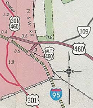
US 460 ALT in Petersburg
1961 Official
|
|
|
Previous: US 450 |
Next: US 466
US 460 | US 460 Bus | US 460 Byp | US 460 Temp | US 460-Y
US 60 | US 160 | US 260 | US 360 | US 560 | US 660
US 460 at US Ends.com
Top | US Routes Index
Home
Page last modified
6 March 2026
| |