< US 11 | Home | US 19 ALT | US 19 Byp | US 19 CONN | US 19 SPUR | US 21 >
|
|
|
|
| ROUTE LOG |
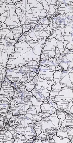
Virginia State Line: 0 - 0 US 52 NB: 1.3 - 1.3 US 52 SB: 0.8 - 2.1 WV 112: 2.8 - 4.9 US 460 WB: 0.3 - 5.2 WV 123: 3.2 - 8.4 US 460 EB: 2.1 - 10.5 WV 104 WB: 1.6 - 12.1 WV 104 EB: 0.1 - 12.2 WV 20: 0.4 - 12.6 WV 10: 4.5 - 17.1 I-77 (exit 20): 11.4 - 28.5 Raleigh-Mercer Line: 7.8 - 36.3 WV 3 EB: 8.8 - 45.1 WV 307: 1.7 - 46.8 WV 307: 2.4 - 49.2 WV 3 WB: 1.8 - 51.0 WV 210: 0.2 - 51.2 US 19 Byp, US 19 CONN: 0.5 - 51.7 WV 41 SB: 1.0 - 52.7 WV 41 NB: 0.8 - 53.5 WV 16 SB: 1.9 - 55.4 US 19 Byp: 0.3 - 55.7 US 19 ALT, WV 16 NB: 3.0 - 58.7 Fayette-Raleigh Line: 2.5 - 61.2 WV 612: 5.7 - 66.9 WV 16 SB, WV 61 SB: 0.5 - 67.4 WV 16 NB, WV 61 NB: 0.6 - 68.0 WV 16: 0.8 - 68.8 WV 16: 6.6 - 75.4 US 60: 7.0 - 82.4 Nicholas-Fayette Line: 5.1 - 87.5 WV 129: 5.0 - 92.5 WV 41 SB: 1.0 - 93.5 WV 41 NB: 4.6 - 98.1 WV 39: 0.7 - 98.8 WV 41: 2.4 - 101.2 WV 55: 4.2 - 105.4 WV 82: 10.8 - 116.2 Braxton-Nicholas Line: 3.2 - 119.4 I-79 SB (exit ): 6.9 - 126.3 WV 4: 4.2 - 130.5 I-79 NB (exit ): 5.7 - 136.2 WV 4 WB: 0.1 - 136.3 WV 5: 4.8 - 141.1 Lewis-Braxton Line: 13.0 - 154.1 WV 4 EB: 3.2 - 157.3 I-79 (exit ): 14.4 - 171.7 US 33 WB, US 119 SB: 6.8 - 178.5 US 33 EB, US 119 NB: 0.1 - 178.6 Harrison-Lewis Line: 8.8 - 187.4 WV 270: 7.6 - 195.0 WV 98 WB: 6.2 - 201.2 WV 98 EB: 0.4 - 201.6 WV 20 SB: 1.4 - 203.0 US 50: 1.4 - 204.4 WV 20 NB: 7.2 - 211.6 WV 131: 1.6 - 213.2 Marion-Harrison Line: 3.6 - 216.8 WV 218: 2.6 - 219.4 US 19 SPUR: 5.4 - 224.8 WV 310: 1.6 - 226.4 US 250: 0.4 - 226.8 Monongalia-Marion Line: 7.5 - 234.3 I-79 (exit 152): 9.1 - 243.4 WV 100: 1.3 - 246.7 US 119, WV 7 EB: 0.8 - 247.5 WV 705: 2.1 - 249.6 WV 7 WB: 3.1 - 252.7 WV 100: 3.7 - 256.4 Pennsylvania State Line: 0.9 - 257.3
|
Creation: An original US route. In the 1925 plan, US 19 would run from US 60 Gauley Bridge northeast via Sutton, Clarksburg, Fairmont and Morgantown to enter Pennsylvania at Port Marion PA headed for Uniontown PA. All of this was a replacement of WV 4.
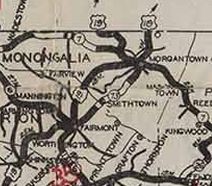
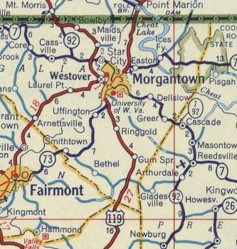
| Adjustments: In July 1926 (AASHO), US 19 was rerouted at Morgantown to head northwest towards Waynesburg PA. The route northeast towards Uniontown along WV 4 became US 119.
Adjustments: In May 1927 (AASHO), US 19 was extended south by heading east on US 21-60 to Chimney Corner, then went with US 21 all the way to Bluefield, then replaced the last bit of unaffiliated WV 4 to the Virginia line at Bluefield VA. This extension was already decided upon in mid-1926. However, the original thought was to send US 19 with US 21 all the way to Wytheville then follow US 11 to Bristol. It took several months to resolve this issue which is why US 19 briefly did end at Gauley Gridge.
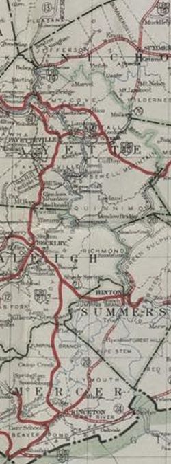
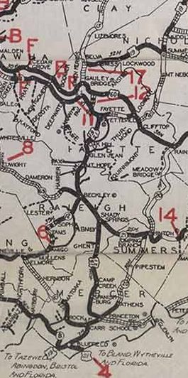
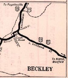
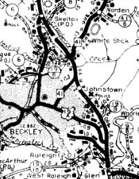
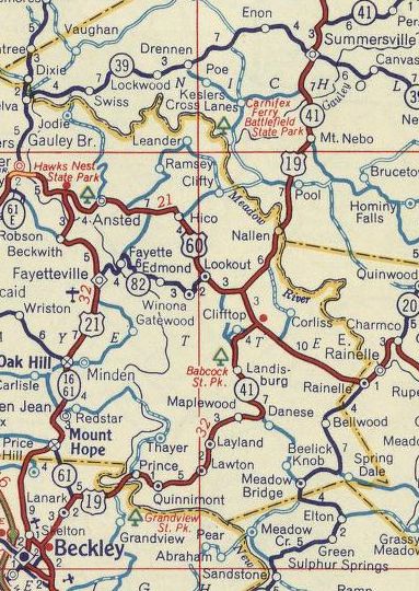
In 1929, US 19 was rerouted at Belva to the current WV 39 crossing of Twentymile Creek. The old route used today's CR 16/6 which no longer crosses the railroad and abandoned routing northwest to the Creek crossing which remained many decades past but is now gone along WV 16 north of the WV 39 jct. About 1931 (WVDOT Annual Report), US 19-21 was removed from CR 19/19 Cherry Creek Cir and CR 119/8 Lamar Cir in Cherry Creek; CR 19/17 Marshall Cir all between Ghent and Shady Spring; also CR 19/28 Ransom Dr, CR 119/20 Little Vine Dr, and CR 19/14 Old US 19 loops above Shady Spring. Also about 1931 (WVDOT Annual Report), US 19-21 was rebuilt from Skelton to Mount Hope and removed from CR 19/5 and CR 4 Prosperity Rd through Prosperity; CR 16/68 Bradley School Rd; CR 19/1 Maple Ln (no longer connects to), CR 1/25, CR 19/43 Sherwood Rd, CR 21/8 Sherwood Heights Rd About 1934, US 19 was given new routing between Bluefield and Princeton. The old route became CR 25 Old Princeton Rd out of Bluefield; CR 25 Mercer Mall Rd to Edison (a bit of this is now WV 123); WV 71 legs (now CR 19/33 Maple Acres Rd to Glenwood; Glenwood/Green Valley/Old Bluefield Rds CR 19/29 from Glenwood to Princeton). Also about 1934 (WVDOT Annual Report), the original Beckley Bypass was completed. It is referred to as "Alternate Route" through at least 1936. Then by 1940, it appears mainline US 19 was moved onto it, leaving behind US 19-21 ALT (now WV 16, CR 21/5, more WV 16, and all of WV 210) through Beckley.
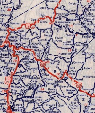
Also about 1934 (WVDOT Annual Report), US 19-21 was put on mostly new construction from Oak Hill to Fayetteville, leaving behind CR 19/2 Broadway Ave and CR 19/1 Nickelville Rd. About 1935 (WVDOT Annual Report), US 19-21 was removed from Covington and Piney Creek Rds near Raleigh (south edge of Beckley) Also about 1935 (WVDOT Annual Report), US 19-21 was put on new construction between Glen Jean and Oak Hill leaving behind CR 20 (now CR 21/20) from Glen Jean to Whipple Jct and CR 15 from Whipple Jct to Oak Hill. Also about 1935 (WVDOT Annual Report), US 19-21 was removed from CR 21/4 Old Court St north of Fayetteville. Also about 1935 (WVDOT Annual Report), US 19 was removed from Colasessano Dr (brick pavement!) which no longer crosses Buffalo Creek to Old Pennsylvania Ave north of Fairmont About 1936 (WVDOT Annual Report), US 19-21 was removed from today's CR 119/6 Sheloh Cir and CR 119/2 Madoc Cir in Cool Ridge In 1936 or 1937, US 19 was removed from CR 19/9 and CR 19/10 Robinson Run Rd in Bowlby. In January 1947 (AASHO), US 19 was rerouted to run directly from Beckley to Summersville as an addition to WV 41. The old route through Fayetteville to Gauley Bridge remained part of US 21 (now WV 16 except US 19 used WV 211 through Mt. Hope) while Gauley River to Summersville became an extended WV 39.
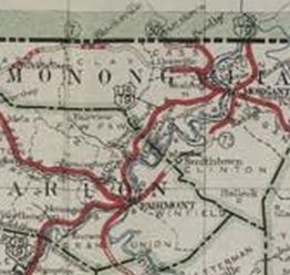
In the early 1950s, US 19-21 was removed from CR 19/31 at Camp Creek and straightened outfrom CR 2 to CR 1 in Mercer County all due to the construction of the West Virginia Turnpike - some of the abandoned pieces are east of the turnpike In 1951 (bridge date), US 19 was removed from CR 19/3 Riverside Dr and CR 19/5 Homewood Rd in Homewood. In November 1957 (AASHO), US 19 was rerouted at Westover to go to downtown Morgantown with US 119/WV 73, then followed WV 92 across the recently built Star City bridge as it does today. The old route from Westover to Bowlby became WV 7 ALT and WV 100 (entire route is WV 100 now).
Between 1950-73, US 19/WV 41 was removed from CR 41/41 Holliday Rd north of US 60. About 1964, US 19/WV 41 was placed on modern US 19 from the Summersville Lake Bridge northward with the old route underneath Summersville Lake and Salmon Run; unnumbered access to the Salmon Run boat ramp; CR 41/16 Broad St About 1972 (bridge date), US 19 was rebuilt at I-79 Exit 91 northward as the old route became about 2 miles of I-79 SB ROW. US 19 was also removed from CR 19/37 Wayside Dr About 1973, US 19 was removed from the lenghty CR 19/40 through Bays, Little Birch, and Tesla to Sutton plus current WV 4 to Flatwoods. Instead US 19 was placed on newly constructed routing directly to the new I-79 over to Flatwoods. In 1974 or 1975, US 19 was removed from CR 43/2, CR 43/1 Old US 19/Willow Tree Ln to Muddlety; the lengthy CR 19/41 through Hookersville and beyond Birch River. In October 1977, the New River Gorge Bridge was opened and this completed the move of US 19 off WV 41 between Beckley and Summersville and placed on all new constructed Corridor L routing (moving US 19 to Corridor L was approved by AASHO in November 1970). Maps are very confusing about this transition, as some parts of Corridor L were open years before the Gorge Bridge and some WVDOT maps labeled pieces on both sides of the bridge as US 19. This seems odd as there is no good detour of the bridge location. Topo maps show some of Corridor L as WV 16 Byp.
Also in 1977, US 19-460 was placed on new alignment in the Green Valley area leaving behind CR 19/33 and a little WV 112. In 1978, US 19/WV 4 was rerouted onto newly constructed alignment from Bulltown to Falls Mill to accommodate Burnsville Lake. The old route followed the Little Kanawha River much more closely. Surviving pieces are the access road to the Picnic Area at Bulltown and the old road from the Falls Mill side to the south dip in the river. About 1983, US 19 was removed from WV 16 Bradley. Also about 1983 (bridge date), US 19 was rerouted around Stonewall Jackson Lake State Park as new construction. The old route used abandoned underwater routing from roughly CR 19/14 to the Stonewall Jackson Lake bridge; State Park Rd north along the W. Fork River to Carrion Run then west as abandoned routing to meet US 19 just south of I-79 Exit 91. About 1995, US 19 was removed from CR 19/66 Old mt Nebo Rd between Mt Nebo and the Summersville Lake bridge. Between 2012-14, US 19 was moved to a new bridge in Shinnston leaving behind Hood Ave and abandoned routing in Shinnston Improvements: Upon designation, US 19 was paved from Weston to Pennsylvania. In 1927, US 19 was paved on its entire extension south to Virginia In 1929, US 19 was paved from Sutton to Flatwoods In 1930-31, US 19 was paved from Ireland to Weston In 1932, US 19 was paved from Gauley Bridge to the Braxton County line; Flatwoods to Ireland In 1933-35, US 19 was paved from the Braxton/Nicholas line to Sutton The first maps to show any multilaning of US 19 was when it joined I-79 from Sutton to Flatwoods. In 1977 when US 19 was moved to Corridor L everywhere, it was multilaned from Bradley to US 60 and also around Summersville. Also in 1977, US 19 was multilaned on its new Corridor Q routing with US 460 between Bluefield and Princeton. In 1983, US 19 was multilaned from Beckley to Bradley. in 1995, US 19 was multilaned from US 60 to Summersville Around 1998, US 19 was multilaned from Summersville to Sutton. Comment: Other than the Corridor L routing, US 19 is more of a local roadway. |
|||||||||||||||