< US 50S | Home | US 52 ALT | US 52 Spur | US 60 >
|
|
|
| ROUTE LOG |
VA STATE LINE: 0 - 0 I-77 NB (exit 1): 0.7 - 0.7 US 460 EB: 2.2 - 2.9 US 460 WB: 1.6 - 4.5 WV 598: 1.4 - 5.9 US 19 NB: 1.6 - 7.5 US 19 SB: 0.8 - 8.3 WV 123: 1.8 - 10.1 WV 20: 2.3 - 12.4 WV 71: 0.2 - 12.6 McDowell-Mercer Line: 6.7 - 19.3 WV 161: 5.1 - 24.4 US 52 ALT: 14.9 - 39.3 US 52 ALT, WV 16 NB, WV 103: 2.0 - 41.3 WV 16 SB: 0.9 - 42.2 WV 80 SB: 14.9 - 57.1 Wyoming-McDowell Line: 4.0 - 61.1 WV 97: 6.4 - 67.5 WV 80 NB: 6.5 - 74.0 Logan-Wyoming Line: 9.2 - 83.2 Mingo-Wyoming Line: 0.4 - 83.6 WV 44: 0.1 - 83.7 WV 65 SB: 10.4 - 94.1 WV 65 NB: 3.6 - 97.7 WV 49: 5.7 - 103.4 US 119 ALT: 2.2 - 105.6 US 119 SB: 0.5 - 106.1 KY STATE LINE: 1.0 - 107.1 GAP IN ROUTE KY STATE LINE: 0 - 107.1 KY STATE LINE: 0.8 - 107.9 GAP IN ROUTE KY STATE LINE: 0 - 107.9 US 119 NB: 4.6 - 112.5 WV 65: 5.1 - 117.6 WV 870: 6.4 - 124.0 Wayne-Mingo Line: 1.4 - 125.4 WV 152: 8.9 - 134.3 WV 37 WB: 17.7 - 152.0 WV 37 EB: 1.1 - 153.1 WV 75 EB: 19.0 - 172.1 I-64 WB (exit 1), WV 75 WB: 1.8 - 173.9 Cabell-Wayne Line: 4.5 - 178.4 I-64 EB (exit 6): 0.6 - 179.0 US 60: 0.7 - 179.7 OH STATE LINE: 0.5 - 180.2
|
Creation: An original US Highway. In the 1925 plan, US 52 entered West Virginia at Huntington and continued east with WV 3 through Charleston, Rainelle and Lewisburg before heading into Virginia on its way to Newport News. During the formation of the US route system in 1925-26, Kentucky complained that they were the only state without an x0 route (guess they hadn't heard of South Carolina). This led AASHO to try to find a different number. After rejecting US 60E and US 150, AASHO renumbered US 52 from Huntongton eastward as US 62 on January 14, 1926. Later that year this became US 60 instead. All of this left US 52's West Virginia route as the bridge from Ohio and 6th St down to US 60 at 4th Ave. It is unclear if 6th St was part of the state route system as WV 8 or some other number prior to US 52 being assigned to it.
|
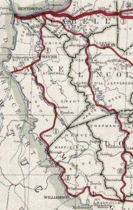
Adjustments: On December 5, 1930 West Virginia requested and AASHO approved on June 22, 1931, US 52 extending over WV 8 through Wayne, Williamson and Welch to end at US 19 Bluefield.
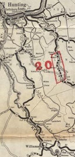
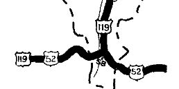
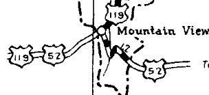
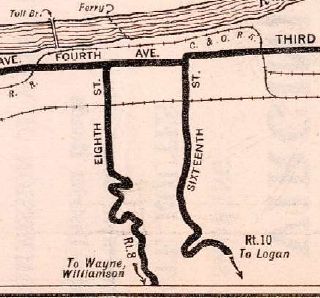
Around the time US 52 was extended to Bluefield, the route was removed from CR 52/12 between Switchback and Maybeury; CR 52/24 High St in Upland; CR 52/92 Broadway St North Fork In 1932 (bridge date), US 52 was removed from Chestnut St in Kimball In 1933 (WVDOH), US 52 was removed from CR 52/39 Camp Rd, CR 52/68 Moore Rd (no longer connects to) CR 52/5 Dickson Dam Rd below Dickson; also CR 52/62 Bloss Hill Rd, CR 152/7 Carolyn Dr (no longer connects to), CR 13 Beech Fork Rd below Lavalette In 1934 (WVDOH), US 52 was removed from CR 52/4 (no longer connects to)-52/6 between Dolph and Bramwell; also Main St in Kimball In September 1934 (AASHO), US 52 was extended to central Bluefield with US 19, then south to Virginia with US 21. In 1934 or 1935, US 52 was removed from CR 11 and CR 37 McCoy Rd north out of Lavalette which becomes 8th St in Huntington. US 52 began using today's WV 152 and WV 527 into Huntington. In 1936 or 1937, US 52 was rerouted at Mountain View to meet then-US 119 at the Mingo County line. Up to then they met at the Island Creek Bridge.
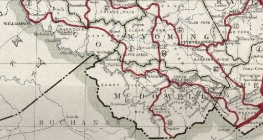
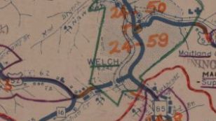
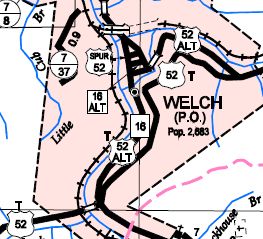
In 1936 or 1937, US 52 was removed from Garretts Creek/Norfolk/Cleveland Sts in Wayne and placed on Kenova Ave; In 1937 (WVDOH), US 52 was removed from CR 52/21 in the Bluewell/Dolph area About 1938, US 52 was removed from CR 11 between Bluefield and Brush Fork and sent directly to downtown Bluefield as it does today. Also by 1938 it appears US 52 was removed from Sycamore and Moore Sts in East Williamson, as well as a partly abandoned loop that used Lt Alex Bucci Rd in Williamson In 1939 (bridge date), US 52 was removed from CR 52/49 Old Twelvepole Rd around Coleman and Echo. In 1940 (bridge date), US 52 was given a more direct routing from Bramwell to Maybeury, leaving behind CR 52/9 (along Simmons Creek to CR 52/1 is no longer a road) in Mercer County and CR 52/14 in McDowell County. In 1945 (bridge date), US 52 was removed from CR 52/17 Pure Energy Rd/Old 52 (no longer continuous to)/Maitland Circle Rd through Superior and Maitland Between 1938-46, US 52 was removed from CR 37/41 (no longer crosses Twelvepole Ck) and WV 37 just below Wayne. Between 1949-52, US 52 was removed from Kenova Ave in Wayne in favor for current WV 152's path through Wayne. It is unclear when US 52 received its one-way splits in Williamson with NB using the original route (4th) and SB using Ben/3rd/Prichard, but I believe it was in the 1950s. I also believe the 1950s is when US 52 received its one-way splits in Welch with NB using the original route Howard St (no longer connects) to McDowell while SB used Elkhorn. About 1960, US 52 was placed on its bypass around the south of Welch, leaving behind US 52 ALT.
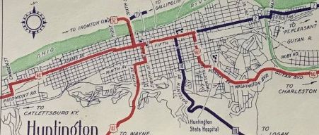
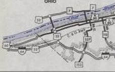
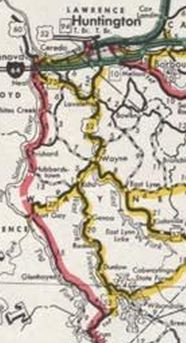
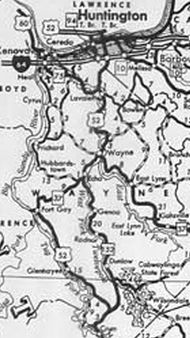
In November 1975 (AASHTO), US 52 was rerouted at Crum to go to Fort Gay (replacing CR 29), then follow WV 37 east back to Wayne. The old route via Dunlow and Genoa became WV 152. In the 1970s(?), US 52 was removed from Backtrack Rd at the Wyoming/McDowell line; CR 52/10 Loop C Rd and CR 52/11 D Loop Rd near Hanover; CR 52/47 Lost Branch Rd (no longer connects to)/CR 52/14 Visitor Center Rd east of Justice Also in the 1970s, US 52 was put on its current routing at today's WV 44 Mountain View eastward, leaving behind a second abandoned routing through this area. In October 1978 (AASHTO), US 52 was rerouted in Huntington to follow I-64 west from today's Exit 8 to Exit 6, then replaced WV 94 across the Ohio River. The old route through downtown and over the 6th St bridge became WV 527.
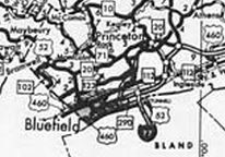
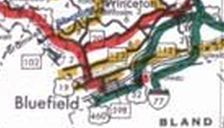
In June 1980 (AASHTO), US 52 was rerouted in Bluefield, replacing WV 290 east to I-77, then south with I-77 through the tunnel into Virginia. The old route from Bluefield to Virginia becmae WV 598.
In November 1980 (AASHTO), US 52 was rerouted at Fort Gay to continue along the Big Sandy River to I-64 at Kenova (replacing the rest of CR 29 and also CR 1 up to WV 75). The old route from Fort Gay to Wayne remained WV 37 and Wayne to I-64 Exit 8 became more WV 152.
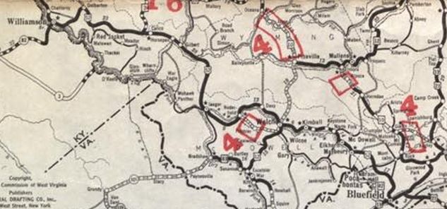
Between 1968-84, US 52 was removed from CR 52/23 Switchback Elementary Rd loop Between 1983-89, US 52 was removed from CR 52/79 Bull Mountain Rd and CR 52/29 River Bend Rd north of Crum; also abandoned route plus CR 52/16 and a bit of CR 52/29 north of the Crum Bypass. In 1991 (bridge date), US 52 was removed from CR 52/38 (no longer connects to)-CR 15-CR 120/1 through Bramwell About 1998, US 52 was placed on its Prichard bypass, leaving behind an abandoned segment; CR 252/14 Heartland Dr and Round Bottom Rd. In November 1998 (AASHTO), US 52-119 was placed on newly constructed alignments north of Williamson that had the route cross into Kentucky a copule times. The old route is CR 15 through West Williamson; CR 14 and 14/14 through Goodman; CR 252/4 north of Nolan Between 1999-2001, US 52 was moved onto newly constructed routing from WV 75 to about halfway to I-64. The old routing is WV 75, Old US 52 (removed from maintenance). In 2011 (FWHA), a new segment of King Coal Highway was built between WV 65 Delbarton and a connector to WV 44. On maps and in the field the King Coal Highway portion is signed as US 52. However the WV 44 connection back to original US 52 is signed as WV 44 only, and US 52 is still signed along the old road, despite county maps showing this as CR 252/57. Improvements: Fully paved upon inception although the 1935-36 reroute between Lavalette and Huntington may have been unpaved at the beginning In 1978, US 52 was multilaned when moved onto I-64 and its new crossing of the Ohio River In 1980, US 52 was multilaned when it was rerouted from Bluefield to I-77 and into Virginia In 1998, US 52 was multilaned from Williamson north to its US 119 split; also on the Prichard Bypass The 1999-2001 reroute of US 52 between WV 75 and I-64 was multilaned Comment: US 52 is slowly being upgraded to expressway standards on mostly new construction: Bluefield to Williamson would be the King Coal Highway, which has a completed segment between WV 44 and WV 65. A segment that would bypass Bluefield is nearing completion and will require using WV 123 to get back to US 52. The segment east of WV 44 was graded for another couple miles but will not be usable for quite some time. If this highway is ever finished it would drop travel time between Williamson and Bluefield from 2 hrs to 45 minutes. Williamson to US 119 split is Appalachian Highway Corridor G and is completed. US 119 to Huntington would be the Tolsia Highway. The Prichard Bypass and the newer segment north of WV 75 are completed. Another 2 mile segment was built about 2001 and is open as CR 152/46 and called the Crum Bypass. These expressway routings are also technically future corridors for I-73/74, despite no plans to upgrade any of it to interstate standards. | ||||||||||||||||||||
Previous: US 50S |
Next: US 52 | US 52 Spur | US 60
Top | West Virginia Hwy Index
Home
Page last modified 29 April 2022